All Activity
- Past hour
-

Potential Tropical Cyclone Nine
NorthHillsWx replied to WxWatcher007's topic in Tropical Headquarters
Humberto being stronger and further west is why the models are showing more interaction/Imelda being pulled east. This is not set in stone hopefully no one lets their guard down but obviously this drastically reduces impacts if the offshore stall occurs. Huge difference in 100 miles at this range -
 Once again revised scoring table to account for (a) Humberto now a major hurricane, and (b) Imelda very likely to form and reach at least tropical storm status. As no forecasters have fewer than 4 hurricanes forecast, for Imelda to reach hurricane status will improve scores by 1 if you predicted 4 hurricanes, by 2 if you predicted five, by 3 if you predicted six, etc. (errors reduced from -1 to 0; -3 to -1; -6 to -3; -10 to -6, etc). I have added a potential score for that possible outcome, in brackets, after the indicated score.
 -
0Z Euro stays away from the US.
-
So I've checked a few other rain gauges by me and the over the past year I'm confident the area around me experienced a 4 standard deviation deficit in rainfall based upon the up to date hydrogeology studies which means I think they need to redo the studies. I'm confident I did not have a 1 in 31500 year bad luck event, even though my luck has been stupidly bad this year with rain. Sent from my SM-G970U1 using Tapatalk
- Today
-

Potential Tropical Cyclone Nine
Coach McGuirk replied to WxWatcher007's topic in Tropical Headquarters
Such a bizarre situation. I don't think we know what will happen. -
Birds everywhere. Can hear em chirping outside as they fly by. https://weather.cod.edu/satrad/?parms=subregional-New_England-comp_radar-24-0-100-1&checked=map&colorbar=undefined
-

Potential Tropical Cyclone Nine
WxWatcher007 replied to WxWatcher007's topic in Tropical Headquarters
Canadian starts out that way, but then gets trapped under the ridge and a much weaker version of future Imelda gets pulled into New England. Verbatim stuff aside, if this becomes a situation where it will be a close scrape of the SE coast, we’ll need to pay close attention to the orientation of this ridge and whether it closes off an escape route as Imelda tries moving eastward. I was always skeptical of Imelda getting well inland and I brought the ridging closing the escape route up as a possibility yesterday. While I’d be skeptical of some sort of threat further north, it really seems like anything is on the table. Anomalous ridging does anomalous things. Sometimes. -
Beer
-
0Z CMC stays OTS unlike 12Z, which looped back to NC So far, all OTS with only Euro left
-
Love the red hill hike. We are 5 min from there.
-
Best rates of the season. Just dumping. https://ibb.co/y3g7BFV
-
Looks like another fish storm
-
Potential Tropical Cyclone Nine
Coach McGuirk replied to WxWatcher007's topic in Tropical Headquarters
Everyone here wants a hurricane to hit. We are all weenies. -
0Z: Icon stays OTS as has been case every run GFS stays OTS 2nd run in a row JMA goes out only 72 but implies it would again get pulled into Humberto and stay OTS UKMET stays OTS as (like the Icon) has been the case every run: NEW TROPICAL CYCLONE FORECAST TO DEVELOP AFTER 30 HOURS FORECAST POSITION AT T+ 30 : 23.5N 77.1W LEAD CENTRAL MAXIMUM WIND VERIFYING TIME TIME POSITION PRESSURE (MB) SPEED (KNOTS) -------------- ---- -------- ------------- ------------- 1200UTC 28.09.2025 36 23.5N 77.3W 1004 38 0000UTC 29.09.2025 48 25.0N 77.5W 1002 38 1200UTC 29.09.2025 60 26.5N 78.0W 1001 38 0000UTC 30.09.2025 72 28.1N 78.3W 998 43 1200UTC 30.09.2025 84 28.3N 78.5W 995 42 0000UTC 01.10.2025 96 27.6N 76.9W 993 38 1200UTC 01.10.2025 108 27.4N 74.6W 991 45 0000UTC 02.10.2025 120 27.8N 71.6W 989 45 1200UTC 02.10.2025 132 28.3N 68.0W 987 48 0000UTC 03.10.2025 144 28.8N 63.5W 989 66 1200UTC 03.10.2025 156 29.8N 59.3W 994 54 0000UTC 04.10.2025 168 30.3N 56.7W 997 41 ——————— CMC next
-
Looking like the stall offshore is real
-
0Z GFS also likely not going to hit the US based on 78 but we’ll see.
-
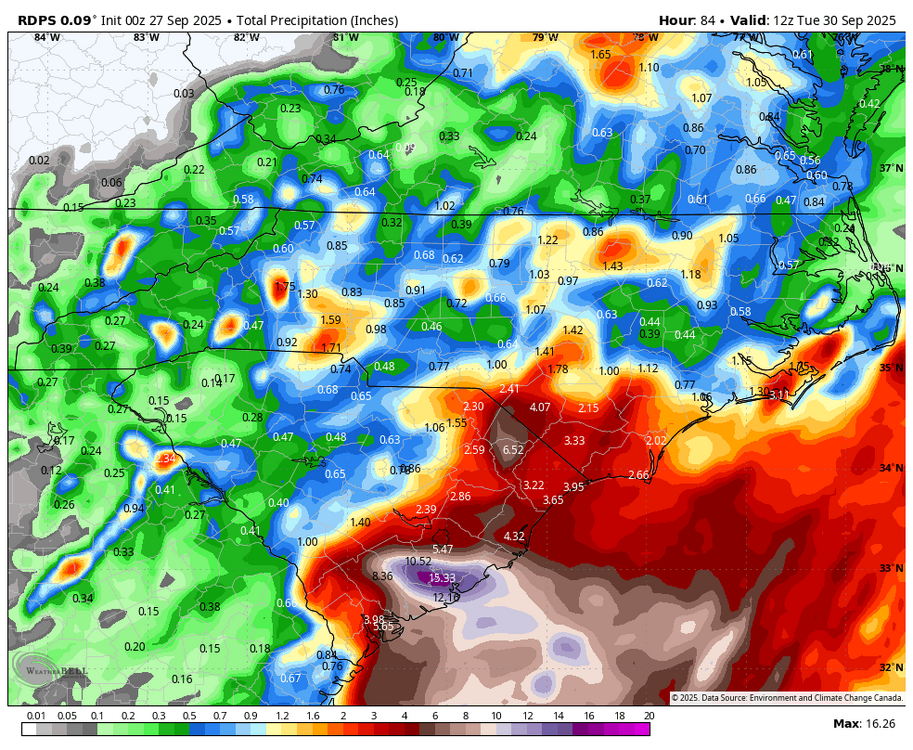
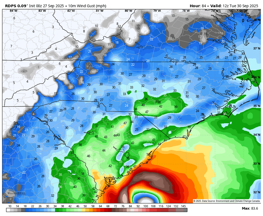
WB 0Z RDPS is closer to the SC coast. Very heavy rains and hurricane force winds close to the coast at the end of the run.
-
0Z Icon is again OTS.
-

September 2025 OBS-Discussion centered NYC subforum
FPizz replied to wdrag's topic in New York City Metro
-
Potential Tropical Cyclone Nine
Coach McGuirk replied to WxWatcher007's topic in Tropical Headquarters
Damn it, don't you watch the X-Files? -
want to believe what?
-
Yeah the writing was on the wall pretty quickly this morning, unabated RI was almost a guarantee.@WxWatcher007was correctly calling for this to be the season of the SW Atlantic… once Erin’s cold pool rebounded, that zone has become rocket fuel once again
-
A stall off the coast is fine with us in Helene ravaged WNC.
-
Potential Tropical Cyclone Nine
WxWatcher007 replied to WxWatcher007's topic in Tropical Headquarters
Humberto is a little west of track and is now forecast to become our second category five hurricane of the season. -
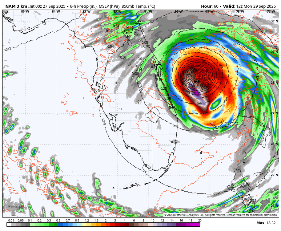
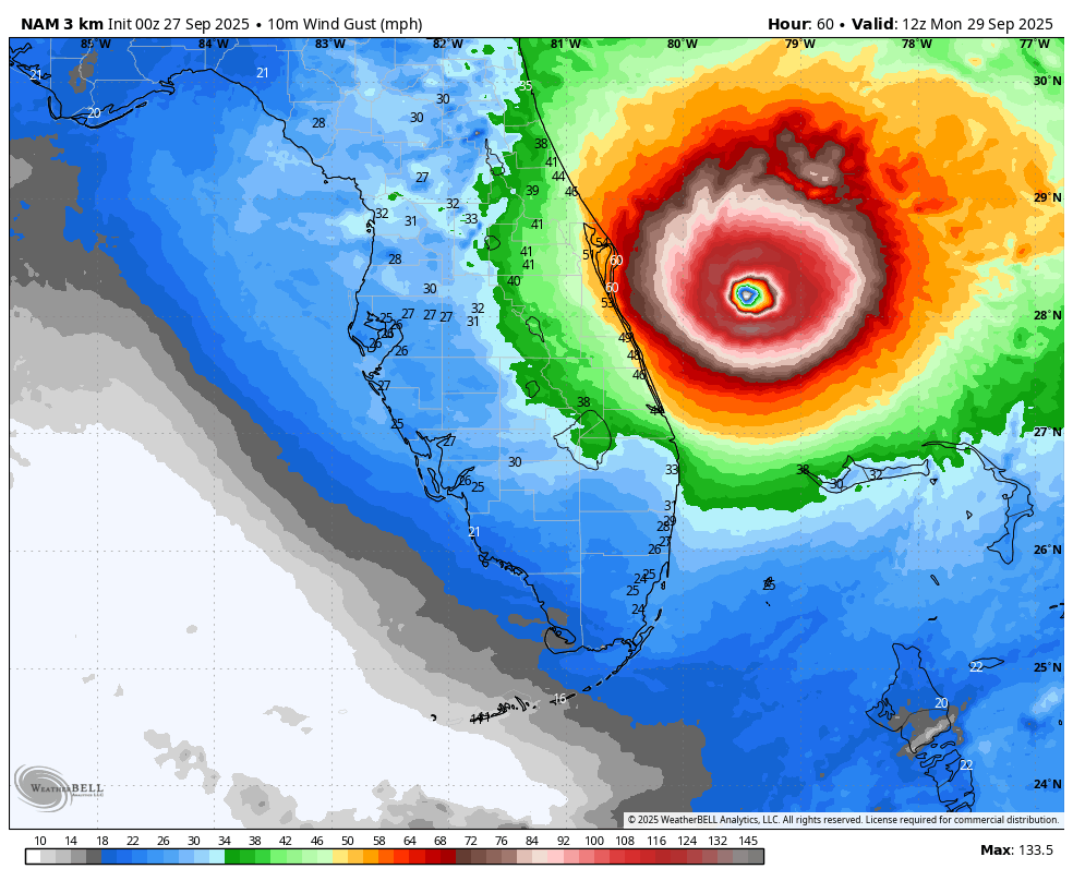
WB 18Z 3K at hr 60 has a hurricane just off the coast of Florida....