All Activity
- Past hour
-
I’ll sign up for thatb
-
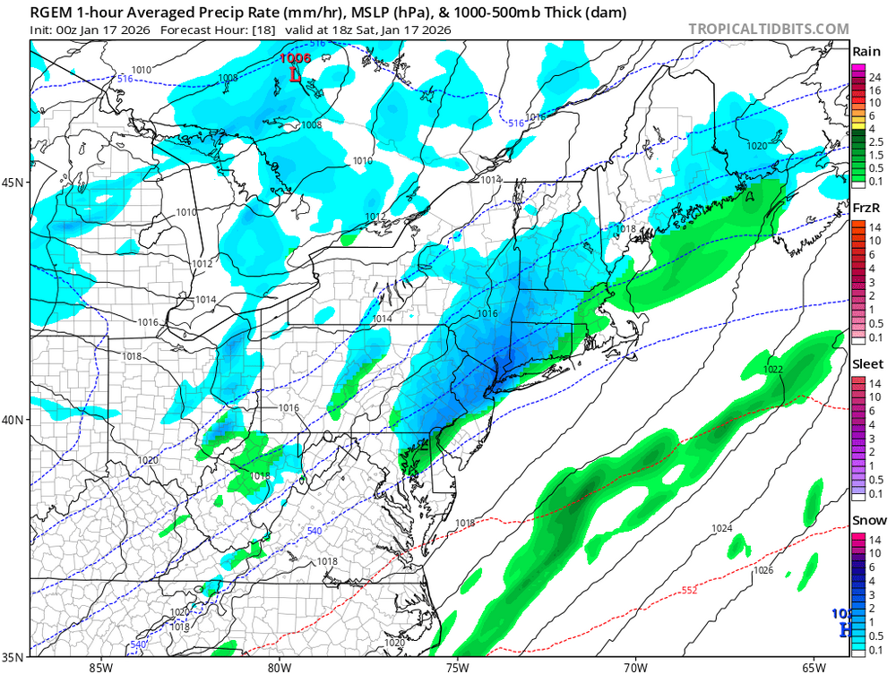
Rgem loves tomorrow more than sunday
-
Pulling me back in lol
-
Just don't look.
-
Most of short range guidance has trended NW ... even the HRW-WRF models
-

First Legit Storm Potential of the Season Upon Us
WxWatcher007 replied to 40/70 Benchmark's topic in New England
Going to be drama all the way to the end. -

First Legit Storm Potential of the Season Upon Us
Baroclinic Zone replied to 40/70 Benchmark's topic in New England
Was the furthest west model, so not surprising. -

First Legit Storm Potential of the Season Upon Us
Sey-Mour Snow replied to 40/70 Benchmark's topic in New England
It has tomorrows snow so much further east too , weird -
Rgem further east for Sunday. Mostly offshore.
-

First Legit Storm Potential of the Season Upon Us
TauntonBlizzard2013 replied to 40/70 Benchmark's topic in New England
East and weak. Went from borderline warning for a lot of SNE to low end advisory -

First Legit Storm Potential of the Season Upon Us
dendrite replied to 40/70 Benchmark's topic in New England
You can see how the 12km really curls the tail of the vortmax in at 48hr versus what the icon and rgem do.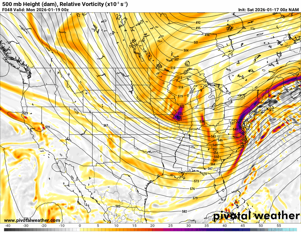
-
Oh NAM why are u doing this to me lol
-
First Legit Storm Potential of the Season Upon Us
TauntonBlizzard2013 replied to 40/70 Benchmark's topic in New England
RGEM with a pretty sizable tick east lol -
NAM and RRFS look pretty good. Icon came in better but still almost nothing verbatim. CMC up next
-
.thumb.png.203fe06300ec450c0dea8e6c29b5d473.png)
-
.thumb.png.8b605ac639ad2376efc07310f5cbeb47.png)
-
Hell of a cutoff but I will take it. The NW trend is undeniable across guidance. Its not done yet.. Cape storm lives!
-

First Legit Storm Potential of the Season Upon Us
Spanks45 replied to 40/70 Benchmark's topic in New England
Looked like it had some banding showing up on our side of CT....its probably wrong, but something fun to look at. I looked at the 18z EURO, even that run the whole system looked a little different than just some strung out system racing off shore. Who knows, guess we can sit back and hope this whole thing pulls a surprise, sort of luke that storm from 2000? Cant remember the date to be honest.... -
What is this evil witchcraft?
-
First Legit Storm Potential of the Season Upon Us
dendrite replied to 40/70 Benchmark's topic in New England
Yeah NNE has been fooled by a zonked 12k run late in the game many a time. Looks like the rgem is a tick east. -

First Legit Storm Potential of the Season Upon Us
Typhoon Tip replied to 40/70 Benchmark's topic in New England
Like I told Ray 10 20 pages ago or whenever the hell it was we’ve been correcting shit west all season. Not saying that’s gonna happen. Just I wouldn’t be surprised. Far be it for anybody in this NOAA administration to come up with an argument of flying special sound emissions in the western Atlantic to see what it would do if we dumped a bunch of latent heat into that region… Gotta be careful with the nam though because it’s got a northwest bias in Western Atlanta at this time range Just some pros and cons -

Storm potential January 17th-18th
the_other_guy replied to WeatherGeek2025's topic in New York City Metro
I dont like the cutoff and I dont like that we keep moving that cutoff a few miles in each direction. This storm has lots of downside and not much upside for Riverhead west. -
RGEM didnt trend unfortunately
-

First Legit Storm Potential of the Season Upon Us
WeatherGeek2025 replied to 40/70 Benchmark's topic in New England
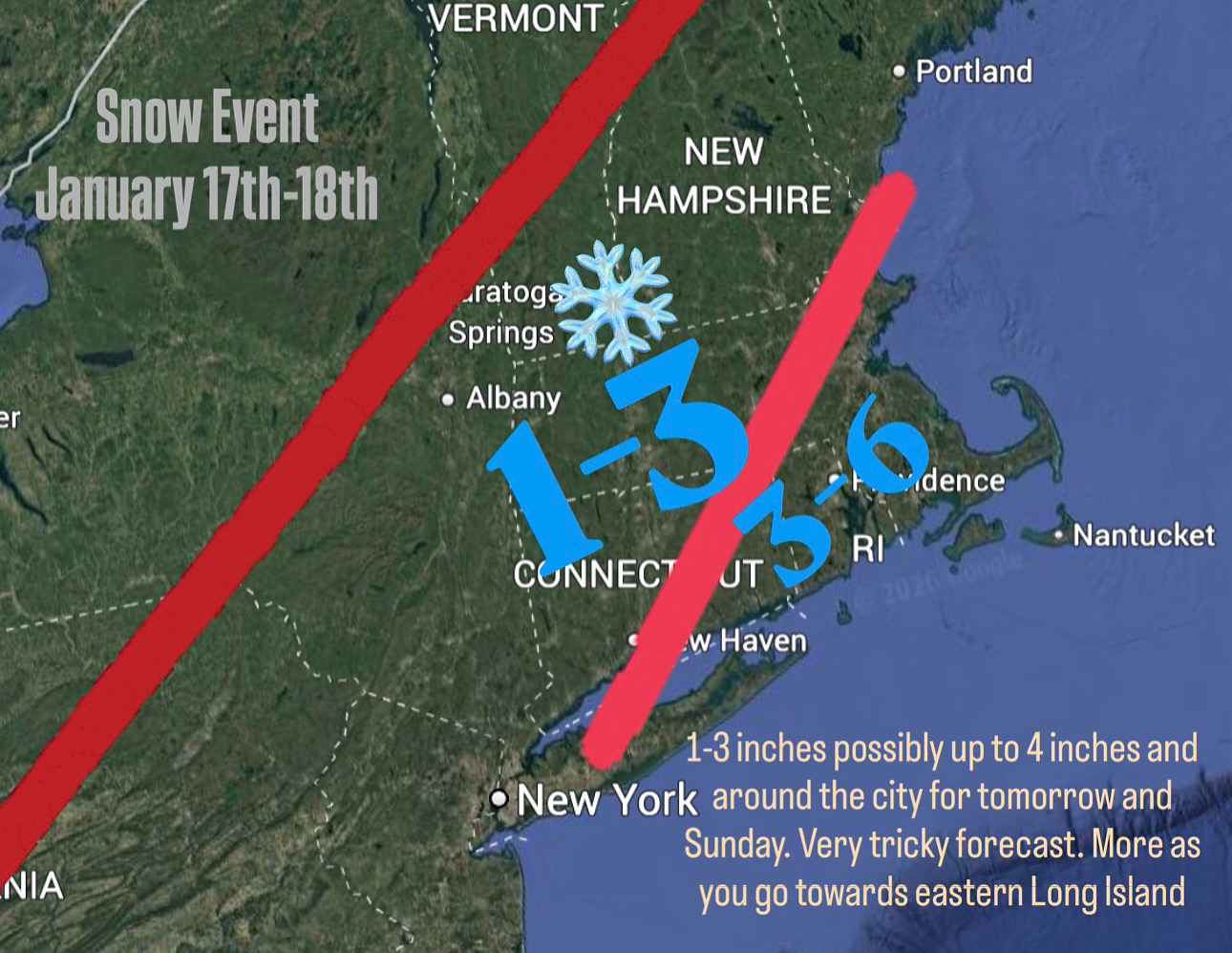
my forecast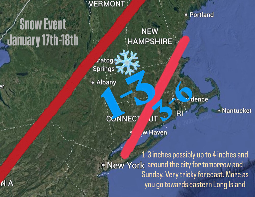
-
First Legit Storm Potential of the Season Upon Us
Sey-Mour Snow replied to 40/70 Benchmark's topic in New England
RRFS gets warning snows to HVN


.png.087e492e9fd7c520aded6254bbd73978.png)
.png.d030733621bd36917ee15b41e5782995.png)