All Activity
- Past hour
-

Central PA Winter 25/26 Discussion and Obs
pasnownut replied to MAG5035's topic in Upstate New York/Pennsylvania
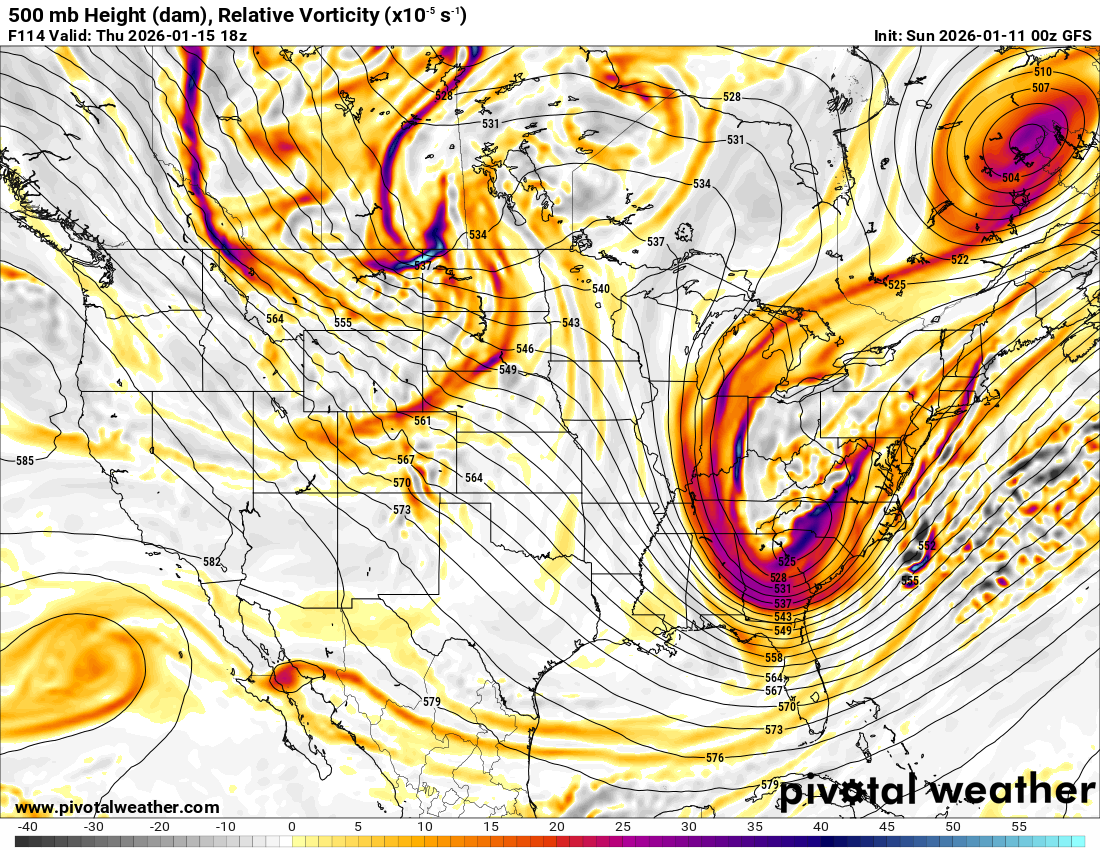
im liking the trough axis and see the 500 lp looking a little sharper/neg tilt. this delays the real deal a bit, but might be worth the wait moving forward (if this look continues to hold). gnight all. -
Storm total rainfall: 0.00”
-
Looked worse to me
-

January 2026 regional war/obs/disco thread
40/70 Benchmark replied to Baroclinic Zone's topic in New England
That storm blows. -
I think it was still a minor improvement H5 level
-
That’s nothing changed from its previous runs
-
The second system looks like it would be primarily an overrunning setup that minors out as it moves east.
-
AI GFS not that interested with light amounts. Inch or less? That's a guess.
-
We don’t get these h5 looks very much. It would shameful to waste another one
-
It’s bad unusually bad this year
-
Storm 2 looks a bit deeper and a touch further SW than 18z. Probably snows somewhere in the southeast/Deep South at the surface with that one too.
-
January 2026 regional war/obs/disco thread
40/70 Benchmark replied to Baroclinic Zone's topic in New England
If it's like 3-6" I really wouldn't care...prefer it TBH. -
Your best post ever
-
This storm isnt going to stall like the gfs did at 12z. I just dont want this to be a Mid Atlantic storm .
-
CMC still not even in the ballpark
-
good juju
-
Really liked the look at 500. Numerous runs have shown a very vigorous piece of energy. In reality it’s probably somewhere between the GFS and Euro, which would mean a pretty good chance at snow for someone on our forum, even if just light.
-
January 2026 regional war/obs/disco thread
40/70 Benchmark replied to Baroclinic Zone's topic in New England
You don't have to tell me that...just saying. -
Looks great at 500 but the precip shield is dried out because there is a double barrel low stealing the precip.
-

Central PA Winter 25/26 Discussion and Obs
paweather replied to MAG5035's topic in Upstate New York/Pennsylvania
0z GFS holds serve -
Call it storm 2/Cape.
-
Ya with the h5 looks like that surface will start showing some big runs.
-
I mean from what is advertised it makes sense but its just crazy to see the main vorticity go from central MN to central MO without moving any further east. An additional question I have is what makes some vorticity to be ropes vs lobes. I understand its a measure of small air parcels spinning counterclockwise which indicates diffusion in the atmosphere which is tied to upper level winds and temp advection but still cant quite grasp why it actually appears like it does.
-
12z was a fantasy
-
Can't be upset with this at 5 days out. Not worth worrying about about the details (temps, banding, etc) now.