All Activity
- Past hour
-
Can you please explain why fronts keep *coming back* instead of just going west to east and passing offshore like they normally do, Tony?
-
Yeah, the early signal that the summer of 2022 would be the warmest in NJ since 2010 was the major upper 90s heat in May. This year the highs were around -10 cooler only reaching the upper 80s. I ageee that the best shot of going over 30 days this summer will be somewhere in NJ like recent summers. But not looking like a repeat of 2022 with 53 days reaching 90°. Someone in the state should reach 30° days this year. The last time the state wasn’t able to reach 30° days was way back in 2014. But we have warmed quite a bit since then. Monthly Data for May 2022 for New Jersey Click column heading to sort ascending, click again to sort descending. NEWARK LIBERTY INTL AP WBAN 98 TETERBORO AIRPORT WBAN 98 Newark Area ThreadEx 98 ESTELL MANOR COOP 96 HARRISON COOP 96 SOUTH JERSEY REGIONAL AIRPORT WBAN 96 ATLANTIC CITY INTL AP WBAN 95 INDIAN MILLS 2 W COOP 95 CALDWELL ESSEX COUNTY AP WBAN 95 AEROFLEX-ANDOVER AIRPORT WBAN 95 SOMERSET AIRPORT WBAN 95 Atlantic City Area ThreadEx 95 EB FORSYTHE NEW JERSEY RAWS 95 Monthly Data for May 2025 for New Jersey Click column heading to sort ascending, click again to sort descending. OCEAN COUNTY AIRPORT WBAN 89 NEWARK LIBERTY INTL AP WBAN 88 HARRISON COOP 88 Newark Area ThreadEx 88 CANOE BROOK COOP 87 TETERBORO AIRPORT WBAN 87 ESTELL MANOR COOP 87 TETERBORO AIRPORT COOP 87 HIGHTSTOWN 2 W COOP 86 NEW BRUNSWICK 3 SE COOP 86 CALDWELL ESSEX COUNTY AP WBAN 86 BELMAR FARMINGDALE ALLAIRE AP WBAN 86 SOMERSET AIRPORT WBAN 86 PHILADELPHIA/MT. HOLLY WFO COOP 86 SALEM COOP 86 New Brunswick Area ThreadEx 86 MILLVILLE MUNICIPAL AIRPORT WBAN 85 ATLANTIC CITY INTL AP WBAN 85 NJ #90 days during the 2020s Data for January 1, 2024 through December 31, 2024 Click column heading to sort ascending, click again to sort descending. HARRISON COOP 41 HIGHTSTOWN 2 W COOP 41 CANOE BROOK COOP 37 SOMERSET AIRPORT WBAN 35 Newark Area ThreadEx 33 NEWARK LIBERTY INTL AP WBAN 33 CALDWELL ESSEX COUNTY AP WBAN 33 TETERBORO AIRPORT WBAN 31 INDIAN MILLS 2 W COOP 31 PHILADELPHIA/MT. HOLLY WFO COOP 30 TETERBORO AIRPORT COOP 30 PENNSAUKEN 1N COOP 30 Data for January 1, 2023 through December 31, 2023 Click column heading to sort ascending, click again to sort descending. ESTELL MANOR COOP 34 HARRISON COOP 33 HIGHTSTOWN 2 W COOP 31 Newark Area ThreadEx 29 NEWARK LIBERTY INTL AP WBAN 29 Data for January 1, 2022 through December 31, 2022 Click column heading to sort ascending, click again to sort descending. SOUTH JERSEY REGIONAL AIRPORT WBAN 53 NEWARK LIBERTY INTL AP WBAN 49 Newark Area ThreadEx 49 HIGHTSTOWN 2 W COOP 49 CANOE BROOK COOP 47 SOMERSET AIRPORT WBAN 46 HARRISON COOP 44 New Brunswick Area ThreadEx 43 NEW BRUNSWICK 3 SE COOP 43 FREEHOLD-MARLBORO COOP 42 ESTELL MANOR COOP 41 INDIAN MILLS 2 W COOP 40 Data for January 1, 2021 through December 31, 2021 Click column heading to sort ascending, click again to sort descending. FREEHOLD-MARLBORO COOP 43 HIGHTSTOWN 2 W COOP 41 NEWARK LIBERTY INTL AP WBAN 41 Newark Area ThreadEx 41 HARRISON COOP 38 CALDWELL ESSEX COUNTY AP WBAN 37 NEW BRUNSWICK 3 SE COOP 36 SOUTH JERSEY REGIONAL AIRPORT WBAN 36 New Brunswick Area ThreadEx 36 SOMERSET AIRPORT WBAN 33 CANOE BROOK COOP 32 ESTELL MANOR COOP 31 PHILADELPHIA/MT. HOLLY WFO COOP 31 PENNSAUKEN 1N COOP 30 Data for January 1, 2020 through December 31, 2020 Click column heading to sort ascending, click again to sort descending. HIGHTSTOWN 2 W COOP 42 FREEHOLD-MARLBORO COOP 40 HARRISON COOP 39 CANOE BROOK COOP 37 CALDWELL ESSEX COUNTY AP WBAN 37 ESTELL MANOR COOP 36 HAMMONTON 1 NE COOP 32 ATLANTIC CITY INTL AP WBAN 31 NEWARK LIBERTY INTL AP WBAN 31 Atlantic City Area ThreadEx 31 Newark Area ThreadEx 31 NEW BRUNSWICK 3 SE COOP 30 FLEMINGTON 5 NNW COOP 30 New Brunswick Area ThreadEx 30
-
Yes it has, way too WET. also high mosquito populations. wet weather is NASTY for bugs!
-
Records: Highs: EWR: 102 (2011) NYC: 97 (1933) LGA: 99 (2008) JFK: 96 (1984) Lows: EWR: 47 (1957) NYC: 47 (1930) LGA: 59 (1980) JFK: 48 (1980) Histrical: 1874:The highest maximum temperature ever recorded in June in Washington, DC was 102 °F. (Ref. Washington Weather Records - KDCA) 1953 - A tornado hit the town of Worcester MA killing ninety persons. The northeastern states usually remain free of destructive tornadoes, however in this case a low pressure system, responsible for producing severe thunderstorms in Michigan and Ohio the previous day, brought severe weather to New Hampshire and central Massachusetts. The tornado, up to a mile in width at times, tracked 46 miles through Worcester County. It mangled steel towers built to withstand winds of 375 mph. Debris from the tornado fell in the Boston area, and adjacent Atlantic Ocea. (David Ludlum) (The Weather Channel) 1966: Hurricane Alma made landfall over the eastern Florida panhandle becoming the earliest hurricane to make landfall on the United States mainland. 1971: The tornado that struck the town of Gruver in the Texas Panhandle on this date is believed to be the widest tornado in U.S. history with an average path width of 2,500 yards. At times, the monster storm was over two miles wide. (Ref. Wilson Wx. History) what a historic day! It was 100+ for two days in a row at EWR in 2011 around this time? Regarding 1874, I didn't know DCA was recording temperatures that early! 1953 might have had the most historic day of all with that massive Worcester tornado and later that summer two historic heatwaves, our longest on record with 4 100+ days between them including one in September!! 1966 had our earliest hurricane landfall and another historic summer with both LGAs and JFKs highest temperatures on record (107 and 104). and 1971 with a tornado well over two miles wide!!
-
Why has this year been so bad? There hasn't been anything exatraordinary about our weather over the last couple months.
-
there's a certain kind of tick that gives you an allergy to meat if it bites you, I call it the vegan tick.
-
wild I wonder what caused that deep blue area, upwelling?
-
Yes 2010-2013 was really good especially for the city and points east, we have tailed off since. Yes the lows were lower in the 40s and 50s, but they are still considered hot and very hot days (which refers specifically to the high temperature). Those days with low humidity are ideal summer weather. Warm and very warm weather can refer to higher averages from elevated lows, as a temperature of 70-75 can be considered warm and 80 can be considered very warm.
-
Latest SST anomalies Atlantic
-
Deer tick nymphs can be the size of a poppy seed. Picked a much bigger one from my ear this morning - either the biggest deer tick I've seen or the first dog tick I've ID'ed here in 10+ years. (But small for the latter species.) Last night's moon was on the orange side of yellow - odd, but kinda pretty. Thanks, Canada.
-
Amazing photos as always Don.
-
Agreed and feel this summer the peak of the heat (above normal) is late July - August and spots east will stay near or mid 20s and C-N NJ 30+ days in the 90s. In 2022 EWR had 4 90 degree days to this point and wound up with 49 90 + days and before then 2016 had 3 90 degree days to this point and wound up with 40. Thursday EWR gets to 2 then will have to wait to the Jun 20 - 30 period to see where June winds up this year.
-
0.93" for Sunday, June 8. Respectable, but just North of me by a few miles was over 2.00"
-
40s/50s had more record lows as well check the daily records posted. 2010 - 2019 #90 days vs 40-40 , 50 -59 i think still trended higher recently (maybe outside the park) . I am trying to find previous posts with the data or online. (We) the part of the area east of the Hudson and Staten Island has been influenced by persistent onshore limiting heat west of there while those in EPA- NJ had many above normal 90 degree days in the past 5 years outside 2023 which was jsut shy of normal amount of 90 degree days.
-
Next 10 days look like a lot of clouds and showers. Couple nice days. Definitely not what you’re expecting this time of year
-
Columbia: 0.21” for Sunday thru 8am Monday.
-
Yeah, we are looking really good here in the East.

-
I got bit this weekend by a small one. I'm going on Doxy today and getting a collar for the dog. He had one seizure last year while one bravecto, collar, and permethrin in the lawn. We are cutting bravecto and the permethrin and hoping the collar on its own doesn't cause seizures.
-
The lawns are green at least. Nothing worse than staring at endless brown dead grass.
-
Yeah, my guess is that the only spots this summer that have a chance of reaching 30 days will be somewhere in NJ. Newark was a little over last summer and a little under back in 2023. Central Park has been so overgrown that they haven’t had 30 days since 2010.
-
This year I've flicked more ticks off of myself than the previous 8 years combined so far when doing yardwork. I've had probably about 8 crawling on me so far. Thankfully zero bites. My dogs are on preventative meds, but I've flicked several off of them as well. It has been nuts.
-

June 2025 discussion-obs: Summerlike
LongBeachSurfFreak replied to wdrag's topic in New York City Metro
I’m ready for the switch to typical south shore warm season drought. It’s been a while since we have had such a cool wet start to the summer. - Today
-
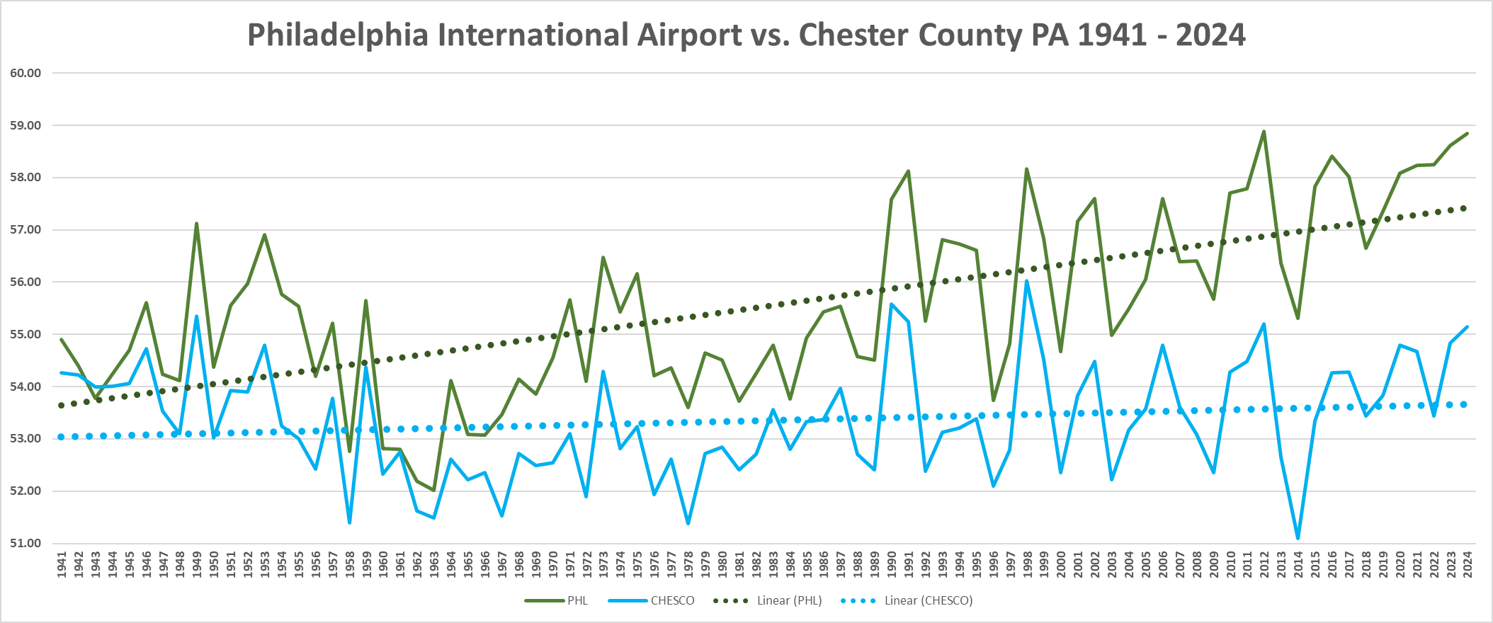
For a actual view of the real data see the below....can you see the UHI problem clearer now Charlie?
-
Did you see that July 2010 heat I posted? I was wowed that we actually once had that kind of climate. 101 degrees and a dew point of 45 and humidity under 15% lol.
-
I doubt we will even get 30 (definitely not here or in NYC)..... my prediction would be for less than 30 90 degree days for EWR too.