All Activity
- Past hour
-

2026-2027 Record-breaking El Nino
GaWx replied to Stormchaserchuck1's topic in Weather Forecasting and Discussion
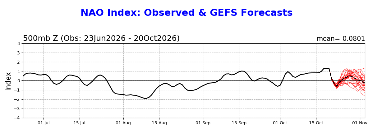
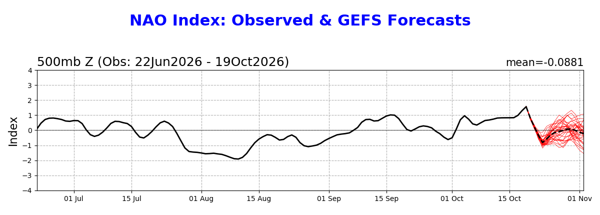
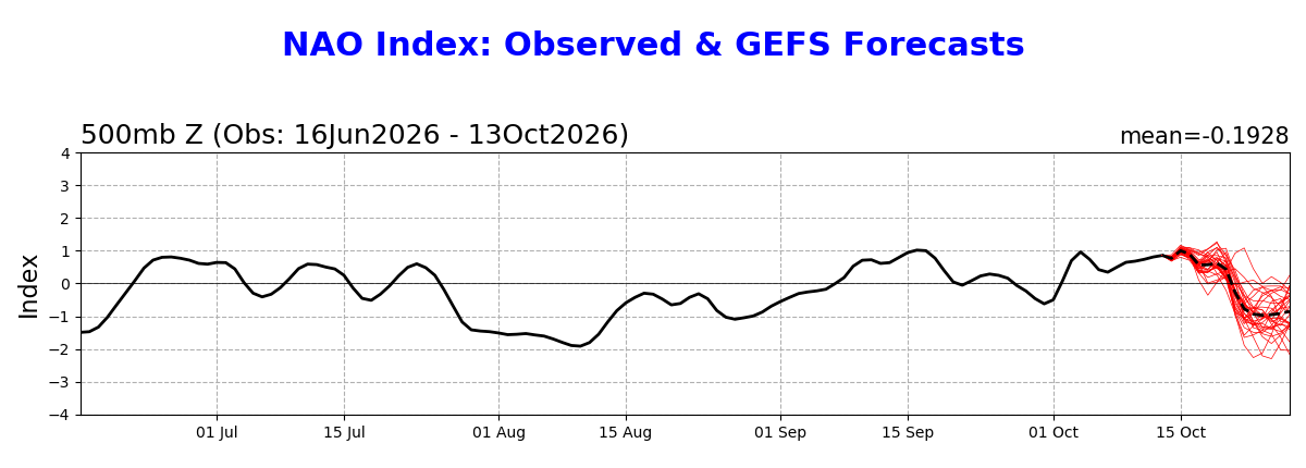
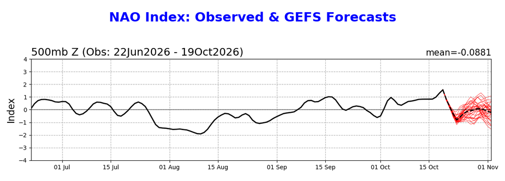
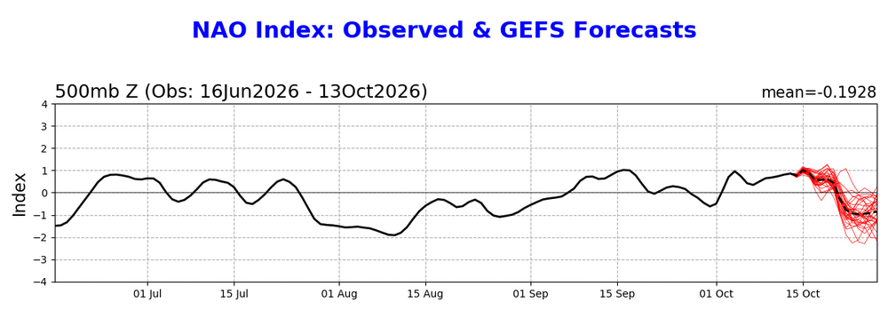
Today’s GEFS NAO forecast is even more positive than yesterdays, which itself was much more + than last week’s GEFS: Today: gets down to only -0.6 and then quickly rises to +0.5 followed by drop back to 0: Yesterday: Last week: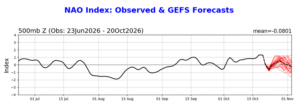
-

2026-2027 Record-breaking El Nino
MJO812 replied to Stormchaserchuck1's topic in Weather Forecasting and Discussion
Majority of forecasts have the Midwest being thr warmest but to say no snow for the Midwest or great lakes is insane. -

Occasional Thoughts on Climate Change
WolfStock1 replied to donsutherland1's topic in Climate Change
Are you honestly proposing that objectivity is mutually exclusive with information and opinions? -

2026-2027 Record-breaking El Nino
michsnowfreak replied to Stormchaserchuck1's topic in Weather Forecasting and Discussion
According to the troll cult, no measurable snow for me this winter. By comparison, Detroit averages 37 days per season with measurable snowfall and in 152 years of record, the least was 15 days (1889-90). I assume this means you shall sprout palm trees by March. Can't wait til verification time! -

2026-2027 Record-breaking El Nino
bluewave replied to Stormchaserchuck1's topic in Weather Forecasting and Discussion
Looks like as we head into late October the expression of ENSO becomes more of split North Pacific low between the Bering Sea and Southern California. It will be interesting to see if these centers can eventually merge into one giant low as we head into November and December. If some semblance of a split remains, then it would be indicative of the background 500mb pattern which has been keeping the PDO negative instead of leading to a +2.00 PDO. -
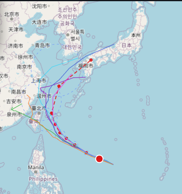
Finally a recurve! Big one too - 180 mph Supertyphoon Champi
-
It’s a good foliage season in Newark this year

-
 https://gabarxdirect.shop/# fibromyalgia gabapentin
-

2026-2027 Record-breaking El Nino
Typhoon Tip replied to Stormchaserchuck1's topic in Weather Forecasting and Discussion
agreed... I mean probably - Here's the thing ( though ) ENSO may not be effective in the hemispheric pattern modulation until the seasonal gradient steepens enough to trigger that forcing. I've explained this in the past ...whether necessary to do so or not ( hey, that's how I roll! ), that it's not enough merely having these teleconnectors on the map. They need to be effective, more importantly ...how to know when/if that is the case. The way they become effecting is through gradient. That is the metric that decides. It goes back to fundamental physics. IF A > B, A --> B That's how all nature works. Period. If that one fundamental universal aspect were not always the case in the cosmological perpetuity and infinity there would be no restoring force anywhere, and everything would stop. A must be greater than B, in order for that action of A on B to take place. So why that is important here. The amount of A had to be significant (enough) bigger than B (gradient) before the "-->" starts happening. Synergy explodes out of "-->" This, to the clever reader, is why RONI is both very necessary and works. Because B is climate change and it is a +D(B) factor. So.. the A growth has to grow even more to trigger the same "-->" Can't be explained any easier... This ENSO is certainly a warm pig, but .. the world is a bigger warm hog right now. So, as eye-popping as this El Nino is, it is not entirely clear that it is operating/forcing on the system yet due to this over all arithmetic. And so if it is not yet doing so, there is no synergy. The synergy would be later on when seasonal/hemispheric gradient gets sufficient and ubiquitous. -
https://dermatretdirect.com/# order roaccutane 20mg
-

2026-2027 Record-breaking El Nino
40/70 Benchmark replied to Stormchaserchuck1's topic in Weather Forecasting and Discussion
Thankfully not pretty similar in NE! -
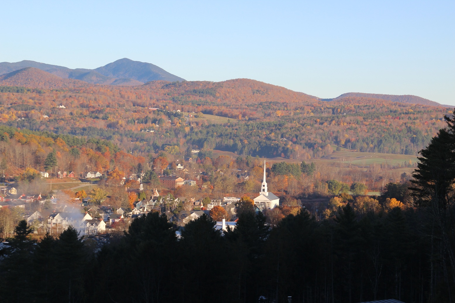
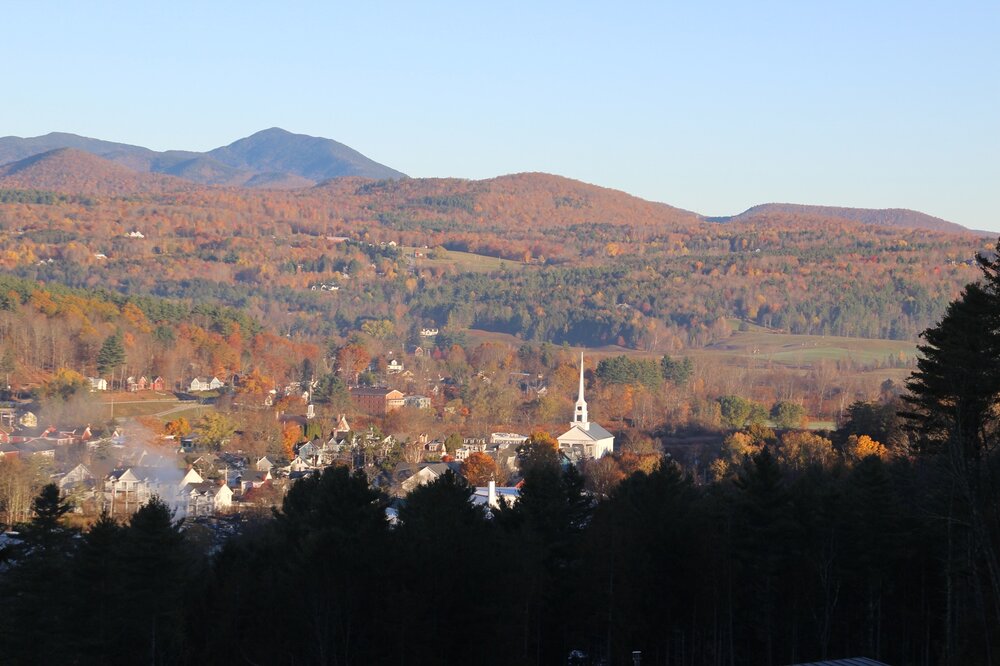
Good Morning Stowe and Powderfreak!
-
October 20 2002: Heavy snow impacts central Minnesota. It fell in a 10-20 mile wide band from southeast North Dakota to around Grantsburg, Wisconsin. Little Falls picked up 9 inches. 1916: Accumulating snow falls in south central Minnesota with 4.5 inches recorded in New Ulm, 4 inches in Farmington and Hutchinson, 3.5 inches in Montevideo, and 3 inches in Faribault. 1835: 6 inches of snow falls at Ft. Snelling. For Tuesday, October 20, 2026 1770 - An exceedingly great storm struck eastern New England causing extensive coastal damage from Massachusetts to Maine, and the highest tide in 47 years. (David Ludlum) 1983 - Remnants of Pacific Hurricane Tico caused extensive flooding in central and south central Oklahoma. Oklahoma City set daily rainfall records with 1.45 inch on the 19th, and 6.28 inches on the 20th. (17th-21st) (The Weather Channel) 1987 - Cold arctic air invaded the Upper Midwest, and squalls in the Lake Superior snowbelt produced heavy snow in eastern Ashland County and northern Iron County of Wisconsin. Totals ranged up to 18 inches at Mellen. In the western U.S., the record high of 69 degrees at Seattle WA was their twenty-fifth of the year, their highest number of record highs for any given year. Bakersfield CA reported a record 146 days in a row with daily highs 80 degrees or above. (The National Weather Summary) (Storm Data) 1988 - Unseasonably warm weather continued in the western U.S. In California, afternoon highs of 96 degrees at Redding and Red Bluff were records for the date. (The National Weather Summary) 1989 - Forty-nine cities reported record low temperatures for the date as readings dipped into the 20s and 30s across much of the south central and southeastern U.S. Lows of 32 degrees at Lake Charles LA and 42 degrees at Lakeland FL were records for October, and Little Rock AR reported their earliest freeze of record. Snow blanketed the higher elevations of Georgia and the Carolinas. Melbourne FL dipped to 47 degrees shortly before midnight to surpass the record low established that morning. Showers and thunderstorms brought heavy rain to parts of the northeastern U.S. Autumn leaves on the ground clogged drains and ditches causing flooding. Up to 4.10 inches of rain soaked southern Vermont in three days. Flood waters washed 600 feet of railroad track, resulting in a train derailment. (The National Weather Summary)(Storm Data) Observances: 20 Tue National Youth Confidence Day 20 Tue World Statistics Day 20 Tue International Day of the Air Traffic Controller 20 Tue International Chefs Day 20 Tue International Sloth Day 20 Tue National Day on Writing 20 Tue National Pharmacy Technician Day 20 Tue World Osteoporosis Day 20 Tue Vijaya Dashami 20 Tue Miss American Rose Day 20 Tue National Brandied Fruit Day 20 Tue Talent Transformation Day 20 Tue World CRISPR Day 20 Tue Information Overload Day
-
generic accutane cost [url=http://dermatretdirect.com/#]purchase isotretinoin pills[/url] accutane discount pharmacy
-
2026-2027 Record-breaking El Nino
bluewave replied to Stormchaserchuck1's topic in Weather Forecasting and Discussion
Which has been the case this year so far leading to much warmer than expected conditions across the CONUS than we typically see from such strong El Niños.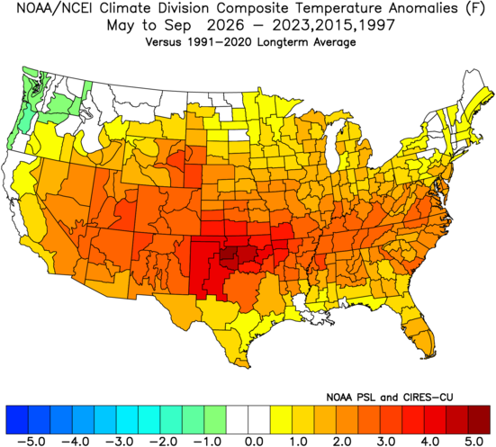
-
Gawx did research on early season warmings and found the only closest matches to this year were 16/17, 79/80 & 09/10, with the last 2 the only Niños. So it may be indicative of future favorable warmings, but that's weenie speculation at this point.
-
2026-2027 Record-breaking El Nino
GaWx replied to Stormchaserchuck1's topic in Weather Forecasting and Discussion
Agreed -
2026-2027 Record-breaking El Nino
Typhoon Tip replied to Stormchaserchuck1's topic in Weather Forecasting and Discussion
yup ... ... There's a synergistic potential there, too - adding a third, the -PDO hangover ... whereby three dominate modes, working together, produce more impact than scalar sum of their input. What makes that trickier than the typical unknown quotient of synergistic result, is that one of these modes is new, and "newing" - in other words, a changing input. It really takes the unknowable synergy, and makes it extra double top secret unknowable. Ha It's tough tho... Folks need to philosophically understand that "more impact" does not mean more scalar amplitude. It can... but impact in the context of ENSO pertains to 'how much does it force the system' - and by that, deviates it from a non-ENSO base. A base that now is D(CC) ... see where this is going? I mean it doesn't mean higher wind gusts and deeper floods, nor satisfying one's snow lusts .. A valid interpretation of these can simply mean more pervasive ...lasting longer ..etc. If NYC go 120" of snow this winter and never snowed more than 8" in a single dose, that would/could likely be a synergistic improvement on just having an El Nino, or CC working alone with a -PDO hangover. 8" is actually manageable. Or... it could mean two consecutive yard-stick bombs totaling a National Guard deployment, sure. Part of the problem for those setting up expectations off El Nino dividends, or subtractions, either way, is that El Nino is not a weather forecast. ...obviously there are those of us that are aware of that but you'd be surprised... heh - Today
-
2026-2027 Record-breaking El Nino
40/70 Benchmark replied to Stormchaserchuck1's topic in Weather Forecasting and Discussion
Right...because it had very similar deviations to the ones I expect with this one. -
2026-2027 Record-breaking El Nino
40/70 Benchmark replied to Stormchaserchuck1's topic in Weather Forecasting and Discussion
This is the strongest El Nino ever partly because we have the warmest oceans ever, which means we have more prominent competing forces than ever. -

2026-2027 Record-breaking El Nino
mitchnick replied to Stormchaserchuck1's topic in Weather Forecasting and Discussion
Idk. 82 was east based and great for the MA. lol -
-
2026-2027 Record-breaking El Nino
40/70 Benchmark replied to Stormchaserchuck1's topic in Weather Forecasting and Discussion
Well, given how east-based this one is, I think you would want some deviation.... -
2026-2027 Record-breaking El Nino
mitchnick replied to Stormchaserchuck1's topic in Weather Forecasting and Discussion
It's not worth arguing about as we'll know in a couple months. It just seems that there's this consensus forecast to disregard the strongest Niño not causing default Niño conditions. And there's an old saying, when everyone thinks alike, people aren't thinking enough. -

2026-2027 Record-breaking El Nino
roardog replied to Stormchaserchuck1's topic in Weather Forecasting and Discussion
Beating that record is not a slam dunk yet then.