All Activity
- Past hour
-
Gfs
-
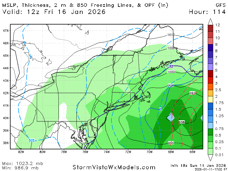
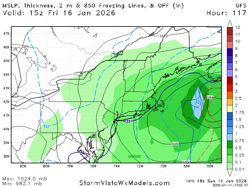
holy cow do we not know how to win. Hopefully its an off run hiccup but they need to get rid of the model. Went from 15 inches to 0 in one full day
-

-
.DISCUSSION... Issued at 1249 PM EST Sun Jan 11 2026 Currently a few snow showers are moving northwest to southeast across mainly northeast Tennessee and southwest Virginia. These showers are producing quick bursts of light to moderate snow for several minutes before quickly moving out, even with temperatures in the mid to upper 30`s. It`s strong enough to cause a dusting of snow accumulations, especially in the higher terrain of the northern Plateau, but once the snow shower moves out anything on the ground quickly begins to melt. Expect these scattered snow showers to continue through the afternoon hours as there is still plenty of returns back into eastern Kentucky that still need to work their way eastward. In addition the winds out of the northwest are gusting pretty good in the higher elevations with numerous places likely seeing 30-40mph gusts. Will continue with the wind advisory for the East Tennessee mountains, especially with winds getting enhanced by the snow showers we`ll likely see periods just above advisory level winds. Quiet weather and a quick warm up to start the work week with highs climbing back into the 50`s for much of the Valley by Tuesday. Front will move through Wednesday along with precipitation. Expect the precipitation to start as rain for most, and temperatures will drop overnight and we switch over to snow. Won`t get too in the weeds with model diagnostics and snow amounts because the one consistent thing with this upcoming Wednesday/Thursday system is that the long range deterministic models do not have a good handle on it at all... Which is to be expected in a northwest flow event that can drastically change based on temp/moisture availability/forcing/etc. It would be a fools errand to pick your favorite deterministic model that shows 6" of snow in the central valley, or (on the opposite end) the model that shows no snow in the valley and just a dusting in the Appalachians... and expect them to verify. In northwest flow snow events it`s a good idea to wait until the higher resolution short term models and hourly models start to ingest the upcoming event. This far out a look at the probabilistic guidance is probably of more use. The 90/95th percentile shows some very extreme amounts, but if you look at the mean/median and the 25-75th percentiles a more traditional northwest flow event is the common sentiment. For example (do not take these values as a forecast) for Knoxville some of the deterministic data shows 5+ inches of snow, but the median/mean and box and whiskers data points to a 0.5-2" event, which aligns more closely to what typically happens in a northwest snow event. Also worth keeping an eye on is the timing of the transition to snow and the best forcing. If you want accumulating snow in the valley you traditionally want your best forcing and heaviest precipitation to occur overnight as during the daytime the sun really limits how productive the clouds are at ice nucleation. So long story short with what might occur on Wednesday into Thursday. LOW confidence in snow amounts (don`t believe just a single model) HIGH confidence snow will occur somewhere with the Cumberland Plateau, southwest VA, and especially the East Tennesse mountains having the best chance to see accumulations. If you have travel plans that involve going over the Appalachians or the Cumberland Plateau plan on possible snow accumulations on the road. Good news is this event looks to be a clean transition from rain to snow, and hopefully keeping the gross icy stuff to a very short window and any ice impacts minimal. Best thing to do right now is pay attention to the forecast updates as the models will likely continue to oscillate wildly in snow potential, and confidence should begin to increase when we`re about 72 hours and higher resolution models and hourly models start to come into play. As we head into the weekend cold temperatures remain in place with yet another possible snow maker looking to move through somewhere over the eastern US. If you thought models were handling Wednesday/Thursday poorly then you don`t even want to glance at the weekend. A lot of what might happen Saturday/Sunday will depend on what happens Wednesday/Thursday, but if you have any upcoming weekend plans keep an eye on the forecast for possible travel impacts in the higher elevations.
-
And we are back to cold and wind. That warm spell while enjoying the warmer temps did not help. Just got diagnosed with Bronchitis as a secondary infection from a Sinus Infection. Happy that my doctors office has weekend walk in hours. And glad it was not the Flu.
-
Snow squall!! 44F
-
Congrats OC to VA Beach with that lol. Still not much.
-
Yup. It is uncanny! .
-
Doesn't work out for us
-

January 2026 Medium/Long Range Discussion
MDScienceTeacher replied to snowfan's topic in Mid Atlantic
We aren’t going to get more snow this year, are we? These models make me so sad. -
We had a solid dusting earlier when the 5-minute squall came through. Mix of heavy graupel and snow. The wind has been ridiculous today. My Xmas tree is on the curb and twice now i've had to chase it more than a block up the street. I finally gave up and put it in the garage.
-
18z gfs may deliver
-
Think that is right - this isn't necessarily digging more, but rather staying too positively tilted for too long.
-
I think the closed low was actually better positioned (further west and neutral/ slight neg tilt) vs 12z
-
shut up ji. At least wait for the euro
-
every time we are at a crossroads...............
-
Gonna need the inverted trough thing with the low offshore NC
-
It's not good
-
The problems in all guidance could not be any more glaringly obvious ... It's all exceptionally highly sensitive to wave spacing issues. Sorry to keep hitting this aspect; I'm not seeing many of you writing about it. The diving "2nd wave" is bullying into the trough, imparting a polar oriented correction vector to the flow - trying to lift it up; that is directly opposing/offsetting the ability for the lead wave space to intrinsically dig/maintain amplitude. done deal. game over. that all has to iron itself out such that: a, one or the other becomes dominant or b, neither will be very significant. or c, some minoring event transpires perhaps out of both -... but in this case, the 2nd is a wild card. And Scott's right big time. The baroclinic axis is getting swept seaward and is not recovering in some of these guidance. That was magnificently spelled out in the 00z GFS, which showed an explosion of squally -linear convection out over the outer g-string, gobbling up al the moisture dynamics and running away with it. There's no other way in nature to demonstrate that without y'all learning Navier-Stokes
-
Maybe 18z too positively tilted?
-
It's either slower than 12z or gunna be not so good.
-
Go figure. Surface looks worse tho 12z Surface was better. This run, H5 is better. I dunno
-
Gonna be a bit north, but lets see
-
While closed at 500mb and a bit west, the trough is also a bit broader and the shortwave out in front robs the best dynamics. It's largely a whiff.
-
Whatever we need to get 3-4 inches. Thanks for the play by play. .


