All Activity
- Past hour
-

Spooky Season (October Disco Thread)
Typhoon Tip replied to Prismshine Productions's topic in New England
I don't think you did... I mean, there's a non-zero chance that thing gets sucked into ...whatever the Euro's selling with that -NAO trough. This becomes a general Met concern Which, by the way folks ... -NAOs, particularly those over the western limb of the domain, which this 10 day period is exerting, is a correlation found with TCs ( in general ..) affecting the EC. I'm not fully convinced that some sort of hybrid or fusion deal can't evolve. It's numerically/telecon Sandy like in some ways... but not exactly modeled as an analog in the synoptic handling at this time. -

Occasional Thoughts on Climate Change
WolfStock1 replied to donsutherland1's topic in Climate Change
I don't see anywhere it saying that deaths have declined because of the climate becoming more stable - if you do please show it. "Benign" however is another matter. Yes part of the reason at least that deaths have decreased is in fact because it has become more benign. This is not due to the climate changing, but rather our ability to deal with climate-caused problems, like flooding, hurricanes, etc. has increased many-fold over the last 150 or so years. So in that sense yes - the climate has become more benign, and yes that has resulted in fewer deaths than otherwise. And yes - that is due in large part to the burning of fossil fuels - e.g. machinery in construction of dams to control flooding, construction of better buildings to withstand hurricanes, etc. It's due to better weather prediction capabilities due to satellites that are put into orbit by fossil-fuel-burning rockets. In short - greater prosperity brings less deaths, and the burning of fossil fuels has brought about greater prosperity. That is the point. You say "without these four variables the claim would be indefensible" - but you can't just remove variables that are key parts of the interconnected system like that! -

2025-2026 ENSO
40/70 Benchmark replied to 40/70 Benchmark's topic in Weather Forecasting and Discussion
Tricky part for me is I not only forecast the sensible weather, but the actual teleconnections, so this may matter to me more than most. Anyway, look forward to what you present. -
Pressure rising and wobbling southwest. Time to take GFS out back and shoot it. With king euro reigning, it'll be very interesting to see how strong this gets in the western caribbean sea.

-
2025-2026 ENSO
40/70 Benchmark replied to 40/70 Benchmark's topic in Weather Forecasting and Discussion
I think the course of least regret is incorporating La Niña analogs, but emphasizing variability with respect to the PNA....including some +PNA cool ENSO analogs, as well...such as 2024 and 2000, which are both stellar polar analogs. -
The million dollar question….does it actually make it into the PAC or does it die out in phases 6/7 and end up back in the IO? The end of month propagation to the Maritime Continent (finally) looks like a certainty now but the MJO has been exhibiting very erratic behavior for the past few months now with barely any eastward movement before it circles right back to the IO
-
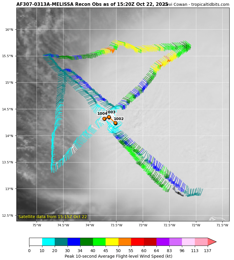
Tropical Storm Melissa Discussion Number 5 NWS National Hurricane Center Miami FL AL132025 1100 AM EDT Wed Oct 22 2025 While Melissa continues to produce bursting convection on satellite imagery, with very cold cloud tops down to -95C, there is little evidence these convective bands are wrapping around the center. West-northwesterly shear of 20 to 25 kt is currently preventing the low-level and mid-level circulation centers from aligning. This downshear tilt with height has also been observed by the latest Air Force Reconnaissance mission, which reported significant winds at the surface in their most recent 850 mb center drop. The initial intensity for this advisory is held at 45 kt, taking a blend of recon observations which had a peak wind of 52 kt at 850 mb, and satellite intensity estimates from TAFB, ADT, and D-MINT. The wind field of Melissa also remains very asymmetric, as evidence of a recent 1040z RCM-1 Synthetic Aperture Radar pass showing the bulk of tropical-storm-force winds east of the center. The tropical storm has slowed down to a crawl this morning, with the estimated motion at 300/2 kt. The track forecast remains challenging today, and strongly related to the storm's structure in the short-term. For the next 12-24 hours, Melissa is forecast to move very slowly to the northwest as it attempts to move into a weakness produced by an broad upper-level trough centered over the Bahamas. Whether or not it turns more rightward into this weakness is related to the vertical depth the various model guidance is depicting. The 06z GFS run, which is the model that has been on the right side of the guidance envelope for days, shows a more vertically coherent system over the next 24-48 hours, and causes Melissa to abruptly turn northeastward over the next 48 hours. While this appears to be an outlier solution, the Google DeepMind ensemble mean (GDMI) also shows this northeastward motion, and a significant fraction of its ensemble members show the Melissa making landfall on the Island of Hispaniola. However, the remainder of the track guidance, including the ECMWF and its ensemble mean, suggest that Melissa will remain misaligned and move more slowly north-northwest over the next couple of days. The NHC track solution slightly favors the latter scenarios, lying just east of the ECMWF mean, out of respect of the reliable GDMI aid. After about 60 h, mid-level ridging begins to build back in to the north, and most of the guidance responds by showing a sharp turn westward, albeit still at a snail's pace. The overall track guidance, GFS and GDMI excluded, has shifted left this cycle beyond 72 h, and the NHC track was shifted in that direction, but not as far south and west as the HAFS-A/B regional models. It goes without saying, this is a very challenging track forecast. The intensity forecast has its own share of challenges. At least in the short-term, vertical wind shear is expected to persist between 20 to 30 kt, and will likely prevent Melissa from becoming fully aligned and taking advantage over the very warm 30-31C sea surface temperatures. After about 48 hours, the GFS and ECMWF-based SHIPS guidance shows the shear decreasing gradually, but the timing on when the system becomes more vertically coherent varies among both the global and hurricane-regional model guidance. Most of the guidance shows significant or even rapid intensification in days 3-5, and the NHC intensity forecast was raised once again during this time frame, but not as high as the HCCA or hurricane-regional models due to continuity constraints to the previous forecast. The day 5 forecast now shows Melissa becoming a major hurricane, and further upward adjustments may be necessary in subsequent cycles. The intensity forecast is also more uncertain than usual, in large part related to the track uncertainty. Key Messages: 1. Melissa is expected to produce heavy rainfall across portions of the Dominican Republic, Haiti, and Jamaica through this weekend, bringing a risk of significant flash flooding and landslides. 2. Hurricane conditions are possible in the southwestern peninsula of Haiti where a Hurricane Watch is in effect. A Tropical Storm Watch is in effect for Jamaica. Preparations to protect life and property should be completed by Thursday. 3. There is significant uncertainty in the track and intensity forecast of Melissa. Interests elsewhere in Hispaniola and Cuba should continue to monitor the latest forecasts. FORECAST POSITIONS AND MAX WINDS INIT 22/1500Z 14.4N 73.6W 45 KT 50 MPH 12H 23/0000Z 14.8N 73.9W 45 KT 50 MPH 24H 23/1200Z 15.2N 74.3W 50 KT 60 MPH 36H 24/0000Z 15.6N 74.4W 55 KT 65 MPH 48H 24/1200Z 16.0N 74.4W 55 KT 65 MPH 60H 25/0000Z 16.3N 74.6W 60 KT 70 MPH 72H 25/1200Z 16.5N 74.9W 70 KT 80 MPH 96H 26/1200Z 16.6N 75.8W 90 KT 105 MPH 120H 27/1200Z 16.4N 77.4W 105 KT 120 MPH $$ Forecaster Papin
-

Spooky Season (October Disco Thread)
WxWatcher007 replied to Prismshine Productions's topic in New England
Sorry, didn’t mean to derail the thread… -
Spooky Season (October Disco Thread)
WxWatcher007 replied to Prismshine Productions's topic in New England
Yeah the shear is unquestionably there currently and will remain, I don’t doubt that, but in a few days as Melissa shifts west and the ULAC becomes the predominant feature, that’s when the window for explosive development is most likely. Still not a guarantee, but looking increasingly likely. Ironically, it’s the 20-30kt of shear now that is keeping Melissa from becoming vertically aligned that will probably lead to a further west track. Melissa can’t muster a sprint into the weakness to its north. From the latest NHC forecast The intensity forecast has its own share of challenges. At least in the short-term, vertical wind shear is expected to persist between 20 to 30 kt, and will likely prevent Melissa from becoming fully aligned and taking advantage over the very warm 30-31C sea surface temperatures. After about 48 hours, the GFS and ECMWF-based SHIPS guidance shows the shear decreasing gradually, but the timing on when the system becomes more vertically coherent varies among both the global and hurricane-regional model guidance. Most of the guidance shows significant or even rapid intensification in days 3-5, and the NHC intensity forecast was raised once again during this time frame, but not as high as the HCCA or hurricane-regional models due to continuity constraints to the previous forecast. The day 5 forecast now shows Melissa becoming a major hurricane, and further upward adjustments may be necessary in subsequent cycles. The intensity forecast is also more uncertain than usual, in large part related to the track uncertainty. -

2025-2026 ENSO
Stormchaserchuck1 replied to 40/70 Benchmark's topic in Weather Forecasting and Discussion
SOI has been positive now 15 straight months.. -AAM the last few months, -PDO, a few things are lined up for cold-ENSO it seems, but without a big ENSO subsurface cold pool it's going to be hard to get N. Pacific -PNA. The subsurface cooling could come back, it waxes and wanes, but the way it looks right now is pretty far from La Nina analogs.. Crazy thing, although SOI has been positive 15 straight months, it has never gone above +10.. so we've been consistently on this weak-cold ENSO thing. I think the past shows us that when that happens the odds for a future El Nino increase. -
2025-2026 ENSO
40/70 Benchmark replied to 40/70 Benchmark's topic in Weather Forecasting and Discussion
@Stormchaserchuck1I would consider 2008 a bit before tossing cool ENSO analogs....that year went on to be a late blooming, bonafide, albeit modest La Niña despite the warm subsurface encroachment from the west....even 1967 got down to -0.7 ONI, though it just missed official designation. Now, I don't think we cool quite as much as 2008 because the trades and SOI are a bit less impressive, but the subsurface is very similar, so I would extrapolate out a bit less development than that year. Keep in mind region 3.4 goes all the way over to 120W, so the warmth has a bit to go and you still have to factor a lag. -
Spooky Season (October Disco Thread)
Typhoon Tip replied to Prismshine Productions's topic in New England
heh too much shear. Doesn't matter where it is. NHC indicated a 'few days' of it. maybe we wait - -

Spooky Season (October Disco Thread)
CoastalWx replied to Prismshine Productions's topic in New England
I think it’s more of a if this drifts more westerly and doesn’t gain latitude type deal. If that happens it could be a biggun. -
0.25" overnight. Unexpected. Welcomed.
-

Central PA Fall Discussions and Obs
WmsptWx replied to ChescoWx's topic in Upstate New York/Pennsylvania
I'm a weird bird in that I love the holidays, I've even come to love Halloween since having a child and have always loved fall/winter (even though I am starting to become a bit of a warminista) but hate the darkness. If we could have 20 hours of sunshine and a dry cold from November 1 - March 15, I'd consider that a jackpot. -
webb and others have said that the current subsurface/sst profile is similar to last year Ninas which transitioned into ninos the next year
-

Spooky Season (October Disco Thread)
moneypitmike replied to Prismshine Productions's topic in New England
A couple short rounds of heavy rain.....radar suggests there might be another. Nothing to write home about. - Today
-
Very cool, wet wx last couple days. Not much precip tho, just scattered shwrs here in town. 0.61" for the month so far (avg 3.03"). Nice band of LER across the Bayfield peninsula this morning. Won't be long, and I'll be updating snow totals in my sig.
-
Spooky Season (October Disco Thread)
Typhoon Tip replied to Prismshine Productions's topic in New England
Meh... we'll see. Shear stress has to diminish, tho. If it doesn't, I 100% disagree. -
Spooky Season (October Disco Thread)
Typhoon Tip replied to Prismshine Productions's topic in New England
Apparently you're not putting much value in NHC's recommendations this morning? ...it's okay. With all the MAGAt parasites succeeding in tunneling out American institutions, there's probably just a skeleton crew of stressed out coffee constipate red-eyed summary efforts coming from NCH latels ... But, suppose for a minute there's substantive value when they tell us that moderate westerly shear will impact the TC for the next few days. That would be inconsistent with your bold comment above. Just sayn' -
Spooky Season (October Disco Thread)
CoastalWx replied to Prismshine Productions's topic in New England
Agree. Some of those Hurr models showing it. -
October 2025 has a global mean temperature of 15.29°C through October 20th (ERA-5). That ranks as the third warmest October 1-20 period on record. October 2025 remains on track to finish as the third warmest October on record (likely with a monthly mean temperature of 15.00°C or above). To miss, the October 21-31 period would need to see sustained cool readings that last occurred in 2013. That is improbable with today's greater greenhouse gas forcing.
-
Spooky Season (October Disco Thread)
WxWatcher007 replied to Prismshine Productions's topic in New England
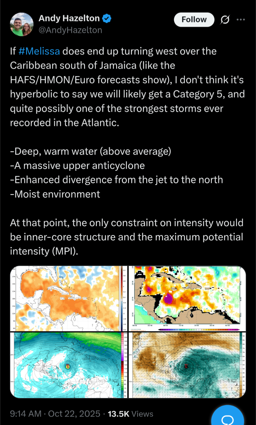
Andy isn’t prone to hyperbole—and it’s not hyperbolic if it’s right. The environment for Melissa increasingly looks as high end as you can get in any part of the Atlantic at any time of year. Without the earlier NE turn across Hispaniola, which the ensembles are starting to abandon, this not only gets to an anomalously warm and deep pool of OHC, it likely sits under a substantial ULAC with an anomalous jet streak to the north that will further aid ventilation. Melissa is meandering into a powder keg with a blowtorch. -
2025-2026 ENSO
40/70 Benchmark replied to 40/70 Benchmark's topic in Weather Forecasting and Discussion
I think one thing we can say for certain is that any cool ENSO is going to maintain an eastern bias with that subsurface.