All Activity
- Past hour
-

December 2025 Short/Medium Range Forecast Thread
Carvers Gap replied to John1122's topic in Tennessee Valley
That is insanely good information, John. -

December 2025 regional war/obs/disco thread
Torch Tiger replied to Torch Tiger's topic in New England
Looks like nothing to track through 12/7, unless something surprises. -
November 2025 general discussions and probable topic derailings ...
Torch Tiger replied to Typhoon Tip's topic in New England
New thread for post 12/7 ;] -

2025-2026 ENSO
40/70 Benchmark replied to 40/70 Benchmark's topic in Weather Forecasting and Discussion
He is speaking from a mid Atlantic perspective. We are fine. -

November 2025 general discussions and probable topic derailings ...
eduggs replied to Typhoon Tip's topic in New England
I agree that IF/WHEN there is a meaningful snow event in SNE, it will likely happen beyond day 10. I think that because there is broad agreement between the GEPS, GEFS, and EPS of no big threat before then. I don't think that because of anything visible in the longer-range. There is still some room to sneak in something wintry before then... e.g., the weak wave over the center of the US on the GFS at day 6 could evolve into something more... or numerous other very minor threats... but none are likely based on the current ensemble spreads. -
Killington and Stowe have opened for skiing. May the snow soon come a few hundred miles south.
-

November 2025 general discussions and probable topic derailings ...
CoastalWx replied to Typhoon Tip's topic in New England
Well as we have said, I think anything meaningful is after the first week. But the interior could sneak something in prior. -
November 2025 general discussions and probable topic derailings ...
eduggs replied to Typhoon Tip's topic in New England
That's an ad hominem. I've been posting about New England weather longer than you have. Where I live (which happens to be very geographically close to your home state), is irrelevant. If you disagree with something I wrote than say so. -

December 2025 Short/Medium Range Forecast Thread
John1122 replied to John1122's topic in Tennessee Valley
I remember a few years ago we passed through phase 8 and it didn't get cold. I believe it was an el Niño, so the mentioned/proposed MVP likely wasn't favorable. I do believe ph 7 is generally normally BN here in winter. The article I linked above noted that phase 7 seemed to be unaffected by the state of the proposed MVP. -
 Southern NJ where you live has literally nothing to do with New England or weather correlation. Even NYC Climo is better then yours man
 -
December 2025 Short/Medium Range Forecast Thread
John1122 replied to John1122's topic in Tennessee Valley
Been reading on the MJO today as I wait for the Tennessee game to start. The MJO phase only affects North American temperatures apparently in relation to the proposed in the paper, MVP (multivariate PNA). For instance, in the article I am reading, phase 5 is only warm if the MVP is also negative. This is from that paper. "The MVP is the first combined EOF of 20–100-day OLR, 850-hPa streamfunction, and 200-hPa streamfunction over the North Pacific and North America. The North American temperature patterns that follow each phase of the MJO change with the sign of the MVP. For example, real-time multivariate MJO (RMM) phase 5 usually leads to warm anomalies over eastern North America. This relationship was only found when the MVP was negative, and it was not associated with El Niño or La Niña. RMM phase 8, on the other hand, usually leads to cold anomalies. Those anomalies only occur if the MVP is positive, which happens somewhat more frequently during La Niña years. Composite analyses based on combinations of the MJO and the MVP show that variability in the Pacific jet and its associated wave breaking play a key role in determining whether and how the MJO affects North American temperatures." The article can be found here. https://journals.ametsoc.org/configurable/content/journals$002fmwre$002f141$002f11$002fmwr-d-13-00118.1.xml?t:ac=journals%24002fmwre%24002f141%24002f11%24002fmwr-d-13-00118.1.xml -
December 2025 Short/Medium Range Forecast Thread
Carvers Gap replied to John1122's topic in Tennessee Valley
Haha. The 18z GFS has freaking hurricane in the Gulf on December 6th. Not sure I have seen that before! -
For regional weather forecasting, beyond 10 days has low predictive utility, even on the ensemble means. And we don't even have anything favorable within that time period yet. Right now we are looking at mostly a storm track to our west with cold snaps on the wake of storms. That's within seasonal norms. If we get a cold and snowy look inside day 10 on multiple ensembles, it's a plausible outcome. Inside day 7 and it's worth getting a little excited about. But IMO, anything outside of that range is fantasy range territory.
-
November 2025 general discussions and probable topic derailings ...
eduggs replied to Typhoon Tip's topic in New England
Don't count your chickens guys/gals. It's risky to lock in a cold Canada based on a 15 day model forecast. Plenty of individual members plus operational runs show only transient cold up there. The ensemble mean blends it to look like wall to wall continuous cold, which it likely won't be. Out to day 10 does not look favorable for wintry weather at the moment on the ensembles. Beyond that gets increasingly unreliable in terms of predictive value. Most of us are passionately hoping for cold and snowy. But we've seen it too often over the past few years where many here bake in unrealistic expectations based on fantasy-range model charts. -
Need the cold to get the snow.
-

Pittsburgh PA Fall 2025 Thread
CoraopolisWx replied to TheClimateChanger's topic in Upstate New York/Pennsylvania
12/9/92 might be my favorite storm, mostly for the nostalgia. -
 SWFEs are such an easy forecast. 5-7” thump followed by slot and drizzle. Could stat padders too.
 -

November 2025 general discussions and probable topic derailings ...
Typhoon Tip replied to Typhoon Tip's topic in New England
Suppression, kind of is negative interference… But yeah, either way we look at it -
(002).thumb.png.6e3d9d46bca5fe41aab7a74871dd8af8.png)
Central PA Fall Discussions and Obs
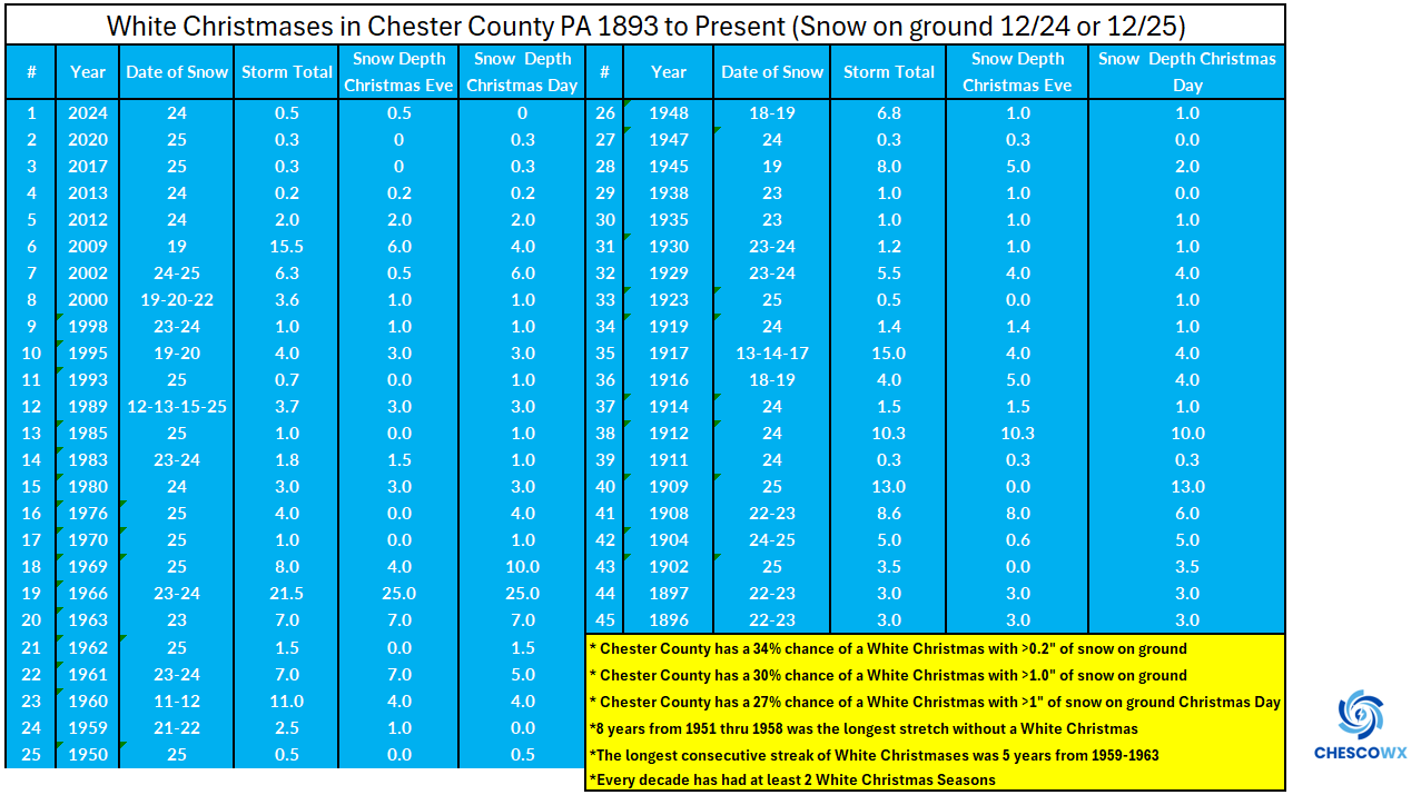
ChescoWx replied to ChescoWx's topic in Upstate New York/Pennsylvania
Some additional details on White Christmas history and probabilities across Chester and SE Berks Counties including the storm dates and snow amounts on the ground both Christmas Eve and Christmas Day.
-
E PA/NJ/DE Autumn 2025 Obs/Discussion
ChescoWx replied to PhiEaglesfan712's topic in Philadelphia Region
Some additional details on White Christmas history and probabilities across Chester and SE Berks Counties including the storm dates and snow amounts on the ground both Christmas Eve and Christmas Day.
-
November 2025 general discussions and probable topic derailings ...
Torch Tiger replied to Typhoon Tip's topic in New England
reasoning there? supression, interference, both? -
November 2025 general discussions and probable topic derailings ...
Torch Tiger replied to Typhoon Tip's topic in New England
07-08 was good but not spectacular in wilmington, ma with around 70" or so iirc. maybe a touch higher like 75"? Best event was probably 12/16 in terms of impacts also iirc -

November 2025 general discussions and probable topic derailings ...
rimetree replied to Typhoon Tip's topic in New England
Gladly take an '07 - '08 winter. Nearest coop was 93". -
November 2025 general discussions and probable topic derailings ...
Torch Tiger replied to Typhoon Tip's topic in New England
maybe for the mid-atlantic, which would kinda be on-par, but I'm far more optimistic around here. - Today
-
November 2025 general discussions and probable topic derailings ...
Typhoon Tip replied to Typhoon Tip's topic in New England
In fact it would harm matters