All Activity
- Past hour
-
Models are all signaling that there will be a winter storm(s) coming up in the next week or 2 - IMO there is a good chance most of the region receives at least 6 inches total for the month.
-
what area did that cover and is there anything still available that i can use?
-
which Jan 94? I see theres Jan 3-4, Jan 7-8 and jan 17-18 1994 on Rays WS Archive. The main archive stops at 94-95 so i wont be doing 93-94 storms unless its a big one, then theyll go in the Historic Snowstorms section. Just havent got to many of them yet. There is 7 so far pre 1994 season. I misread the thing i quoted i thought he said 95.
-

February 2026 Medium/ Long Range Discussion: Buckle Up!
Herb@MAWS replied to Weather Will's topic in Mid Atlantic
Yeah, the cold got real south. Was in San Juan for a week. Even there yesterday the “chilly” high was 76 while, plus/minus 85 rest of my week. Weird Feb day for them. Off and on heavy tropical-like rain. 3” in general, 6” in spots. Interesting reading the NWS Office’s daily AFDs to see the unique factors that make up their forecast. They’ve been talking about the side effects from our cold airmass. Rained so bad I couldn’t fly island to mainland yesterday. -

February 2026 Medium/ Long Range Discussion: Buckle Up!
Weather Will replied to Weather Will's topic in Mid Atlantic
WB 0Z EURO AI held.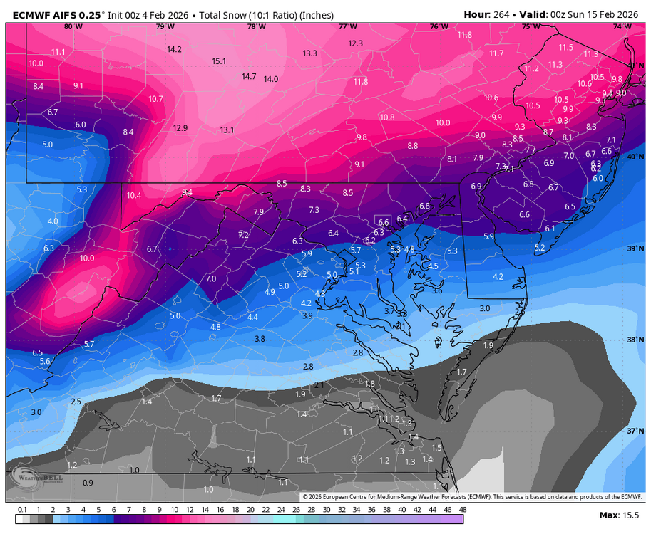
-
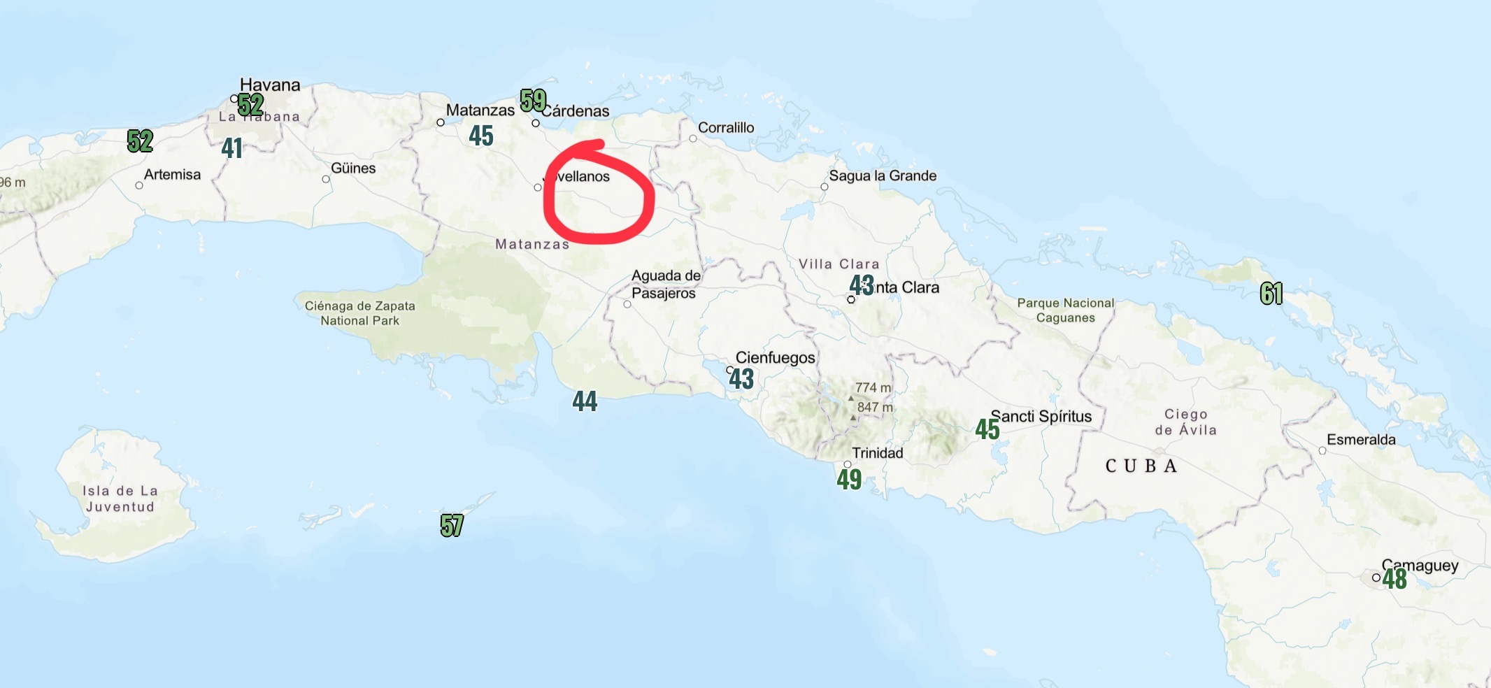
 There’s a lot of junk reported obs here too. Here’s the mins from the morning of the 3rdand about where that location seems to be.
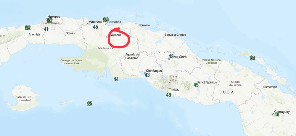
-
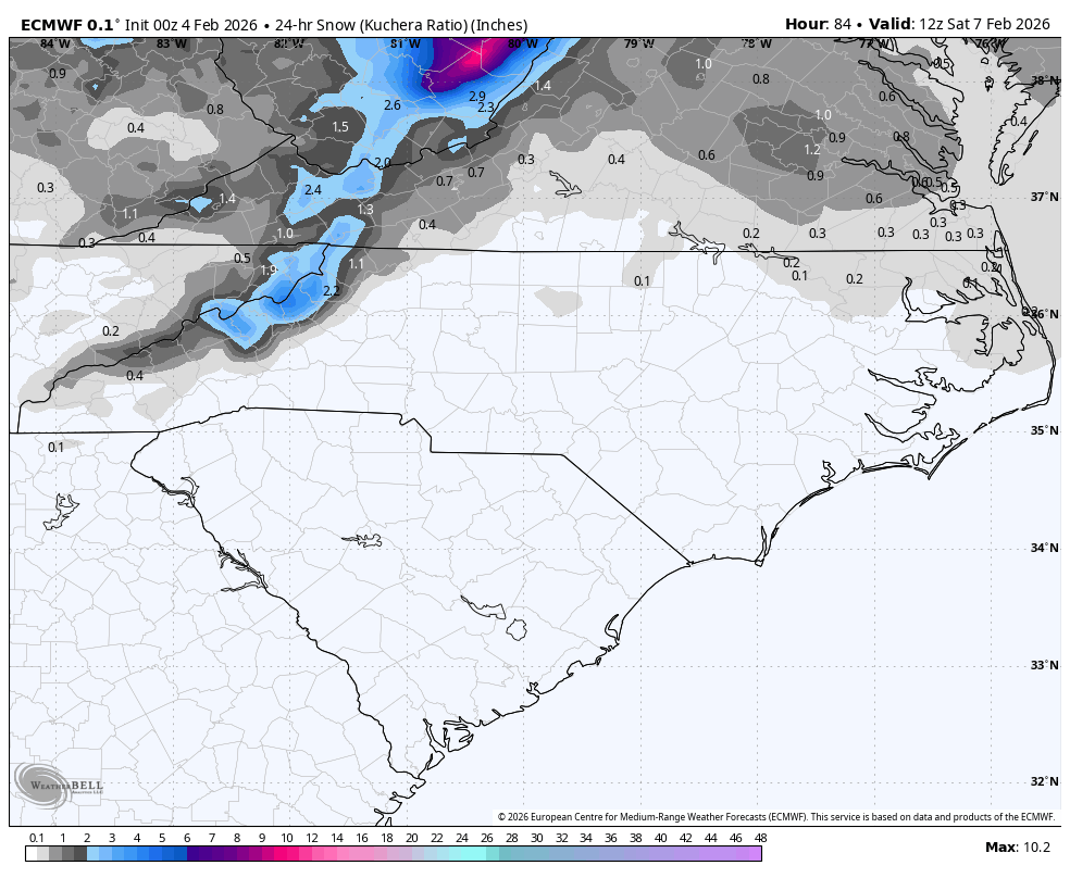
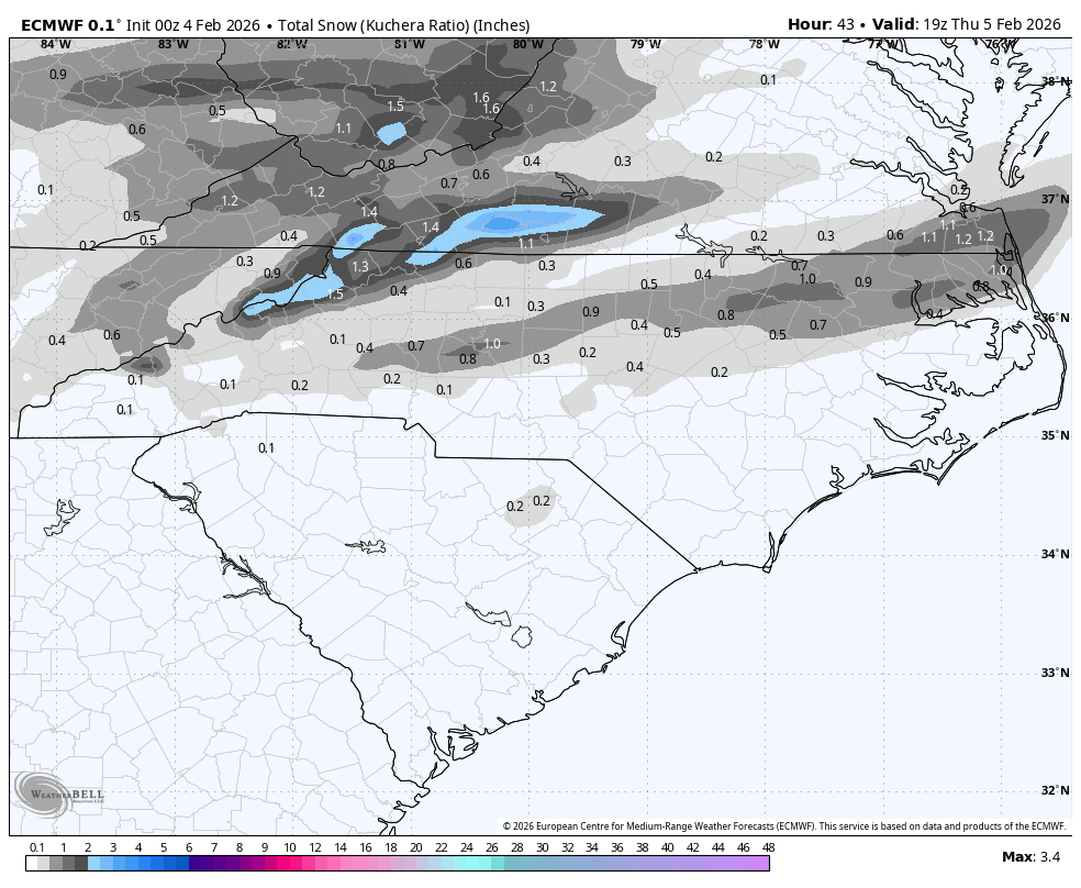
137 AM EST WED FEB 4 2026 ...WINTER WEATHER ADVISORY IN EFFECT FROM 6 PM THIS EVENING TO 10 AM EST THURSDAY... * WHAT...MIXED PRECIPITATION EXPECTED. TOTAL SNOW ACCUMULATIONS UP TO ONE INCH AND ICE ACCUMULATIONS AROUND A LIGHT GLAZE. * WHERE...A PORTION OF CENTRAL NORTH CAROLINA. * WHEN...FROM 6 PM THIS EVENING TO 10 AM EST THURSDAY. * IMPACTS...ROADS, AND ESPECIALLY BRIDGES AND OVERPASSES, WILL LIKELY BECOME SLICK AND HAZARDOUS. * ADDITIONAL DETAILS...RAIN IS EXPECTED TO CHANGE TO LIGHT SNOW OVER THE PIEDMONT TRIAD EAST ALONG AND NORTH OF INTERSTATE 85 LATE THIS AFTERNOON AND EVENING. THE SNOW ACCUMULATIONS WILL BE LIGHT, MAINLY LESS THAN 1 INCH. ELSEWHERE, A CHANGE TO A MIXTURE OF LIGHT FREEZING RAIN AND DRIZZLE WILL OCCUR THIS EVENING. TEMPERATURES WILL RAPIDLY FALL BELOW FREEZING OVERNIGHT CREATING HAZARDOUS TRAVEL IN THE ADVISORY AREA.
-
It's odd because we had reports in our RICONN wx observation network from PVD
-
Is that Salem 3.6SE you on cocorahs? its almost in the exact same spot you described
-
No Jan 94?
-

Predict the cold contest (for Feb 7-9)
NorthShoreWx replied to Roger Smith's topic in New York City Metro
Max 16⁰ ... Min 6⁰ ... Snow : 0.4" -
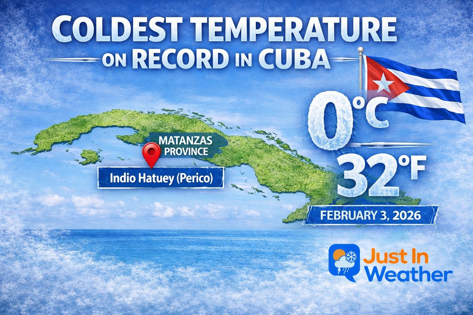
 Of course you will but it's from a certified wx station sanctioned by Cuba wx service so there is that
 -
-
Lol I will toss that.
-
Quite an impressive stretch you have to admit since Jan 27 w/ widespread lows in the single numbers in New England w/ many cold spots below zero. ORE has been as low as -18 F and OWD -16 F. And this going to continue right trough Fri, a break Sat, then Sun-Tue again. CoastalWx *should* like this cold b/c it preserves his "white gold." LOL.
- Today
-
Lol

-
Yeah, that’s better for NC than your area. But you should like this next one better for your area but it’s from a followup system, not the system this thread is addressing:

-
Friday February 6 FROPA / WINDEX small event
Ginx snewx replied to HoarfrostHubb's topic in New England
Let's 40 to 1 J.SPIN style and call it a day.png.104d5e2f87c061acb5efef9da44648da.png)
-
34.3 and that rain that you know that wants to be snow.
-

E PA/NJ/DE Winter 2025-26 Obs/Discussion
KamuSnow replied to LVblizzard's topic in Philadelphia Region
A few flakes of snow here, 29°F. Made it to 35 here today, but didn't really lose any snowpack. We discussed taking a shot at sledding on the sleet pack later this week, lol. -
Max 18 Min 7 Snow 0.8 Sent from my SM-S926U1 using Tapatalk
-
-
Max 21 min 9 snow trace
-
0Z Euro:

-
Wakefield NWS is saying maybe an inch tomorrow and into tomorrow night. We shall see.