All Activity
- Past hour
-
I have a open field to my S and W, decent tree coverage to the N and E so hope that helps me
-

“Cory’s in NYC! Let’s HECS!” Feb. 22-24 Disco
moneypitmike replied to TheSnowman's topic in New England
Too bad I need to miss it. I'll be long dead before another one like this comes along. -
(As posted on PHL thread) The very rapid pressure falls (especially if GFS most accurate) off the NJ coast will result in wind gusts of 60 to 70 mph, as winds always overperform standard gradient metrics when pressure is falling very rapidly. This will probably apply to Long Island as well. Some parts of central NJ could easily see over 30 inches of snow. There could be bands of 20-25 inch accumulations further north over metro NYC and Long Island also. Drifting will be severe due to the wind speeds. In open areas there could be 4-6 ft drifts near the end of the event. (would say 6-8 ft in parts of NJ). This is all of course dependent on GFS verifying as to details of the bomb cyclone formation. Would cut most of this down by one third or more if there is a weaker bomb further from NJ to LI coasts. It has to be said, this is shaping up to be a potentially very dangerous situation, fortunately the worst conditions may be Sunday night and travel may become impossible by Monday morning which at least will prevent a lot of people from getting into dangerous situations, they will be trapped at home and probably digging out most of Tuesday. Temperatures won't be brutally cold but with these wind speeds, wind chills will be a factor. I think temps will stay fairly close to 30F through most of the snowfall period.
-
“Cory’s in NYC! Let’s HECS!” Feb. 22-24 Disco
moneypitmike replied to TheSnowman's topic in New England
Take the "expected" up -

“Cory’s in NYC! Let’s HECS!” Feb. 22-24 Disco
Ginx snewx replied to TheSnowman's topic in New England
Scooter how much snow yesterday today? -
Do able but it will be snowing at that point. And even landing at 1:40pm you’ll have snow falling.
-
Awesome pic wow
-
“Cory’s in NYC! Let’s HECS!” Feb. 22-24 Disco
Ginx snewx replied to TheSnowman's topic in New England
10 to 15 ft drifts with bare spots? What ae your tide times. More Hoth 2015 pics enroute. -
“Cory’s in NYC! Let’s HECS!” Feb. 22-24 Disco
Ginx snewx replied to TheSnowman's topic in New England
4 ? Lucky -

“Cory’s in NYC! Let’s HECS!” Feb. 22-24 Disco
ScituateMA replied to TheSnowman's topic in New England
I have no sheltered places on my property. The wind whips far too much on the coastal plain. Even in the last storm which was very mild from a wind perspective. -

“Cory’s in NYC! Let’s HECS!” Feb. 22-24 Disco
codfishsnowman replied to TheSnowman's topic in New England
Oh yeah its on every model. I can only hope that I am close enough to the CT border to get out of some of it because things look better not far from therea. I'm not excited about this storm, I am actually really worried of what I will see going on all around me. Actually the tracking part will be the most fun part of this. -
“Cory’s in NYC! Let’s HECS!” Feb. 22-24 Disco
Ginx snewx replied to TheSnowman's topic in New England
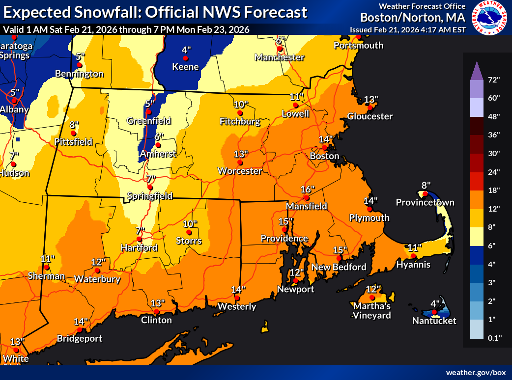
So 15 to 30 across all of SNE.thumb.png.3c4e7e84c2a88637b32c6775cbeb53cd.png)
-

“Cory’s in NYC! Let’s HECS!” Feb. 22-24 Disco
CoastalWx replied to TheSnowman's topic in New England
Ray, FFS relax and just enjoy how this unfolds. -
“Cory’s in NYC! Let’s HECS!” Feb. 22-24 Disco
Ginx snewx replied to TheSnowman's topic in New England
Average depth in a wind sheltered area. The forest in my backyard here helps slow ne and e winds. -

“Cory’s in NYC! Let’s HECS!” Feb. 22-24 Disco
The 4 Seasons replied to TheSnowman's topic in New England
That's the place to be with this storm -
My P&C forecast is 12-20 lmao. LFG!
-
“Cory’s in NYC! Let’s HECS!” Feb. 22-24 Disco
ScituateMA replied to TheSnowman's topic in New England
New BOX maps. The 1 in 10 map is absolutely bananas for south shore MA. Especially western plymouth County..thumb.png.dd24584a92748247bbcf0feb62c38a51.png)

-
Don’t really have the internet bandwidth to view model runs here, but does it still look like 1:40pm landing at JFK is doable plus 4-5pm driving arrival in central NJ?
-
“Cory’s in NYC! Let’s HECS!” Feb. 22-24 Disco
moneypitmike replied to TheSnowman's topic in New England
Haven't been there since 2019 or so. Still have the place in Maine (likely for just 1-2 more years) and have a new Pit in Mattapoisett on the south coast. -
That’s exactly what’s gonna happen unfortunately… .
-
If the GFS verified verbatim there would probably be 60-70 mph wind gusts along the NJ coast, when you get pressure falls that rapidly the wind tends to overperform the usual gradient rules which might suggest 40-50. There could easily be 30 inches of snow in parts of central NJ also (if there is 100% verification). I would expect that to taper off to 15" by Allentown to n/c MD, so PHL around 24". What is the all-time record snow (storm total) for PHL or any other location in the vicinity? I would be grateful if anyone could post a top ten, partly for comparison and then I could look at analogues (I know there's an analogue list available but they tend to cut those off after a lot of historic 100-150 year storms, for which there are still maps available). I can see some similarity in the track evolution of this with the Blizzard of March 1888 but the heaviest snow with this could fall earlier in the cycle (meaning NJ instead of CT).
-

“Cory’s in NYC! Let’s HECS!” Feb. 22-24 Disco
ineedsnow replied to TheSnowman's topic in New England
I hate to.say it but the valley might get shadowed a bit -
“Cory’s in NYC! Let’s HECS!” Feb. 22-24 Disco
moneypitmike replied to TheSnowman's topic in New England
That depiction says it all: any of the variance is in E/W placement. No northern opportunity depicted. -
“Cory’s in NYC! Let’s HECS!” Feb. 22-24 Disco
codfishsnowman replied to TheSnowman's topic in New England
Thank goodness! I never ever thought I would be rooting for that model. -
“Cory’s in NYC! Let’s HECS!” Feb. 22-24 Disco
moneypitmike replied to TheSnowman's topic in New England
I doubt I'll muster a snow day. Even if if I somehow manage several inches here, my office in Waterville will max at 1-2.


.png.8a61dd944c5f411e3d618ccd22fcf66f.png)


.png.562f6b1a59477771db71417357ca059c.png)