All Activity
- Past hour
-

December 2025 regional war/obs/disco thread
Damage In Tolland replied to Torch Tiger's topic in New England
Already roaring this morning. This is gonna be a special one around here today. -
.34” per mesonet near me. I thought it was supposed to be closer to an inch haha
-

December 2025 regional war/obs/disco thread
moneypitmike replied to Torch Tiger's topic in New England
I'll be in Maine for Christmas........don't steal the snow SNE! -

2025-2026 ENSO
donsutherland1 replied to 40/70 Benchmark's topic in Weather Forecasting and Discussion
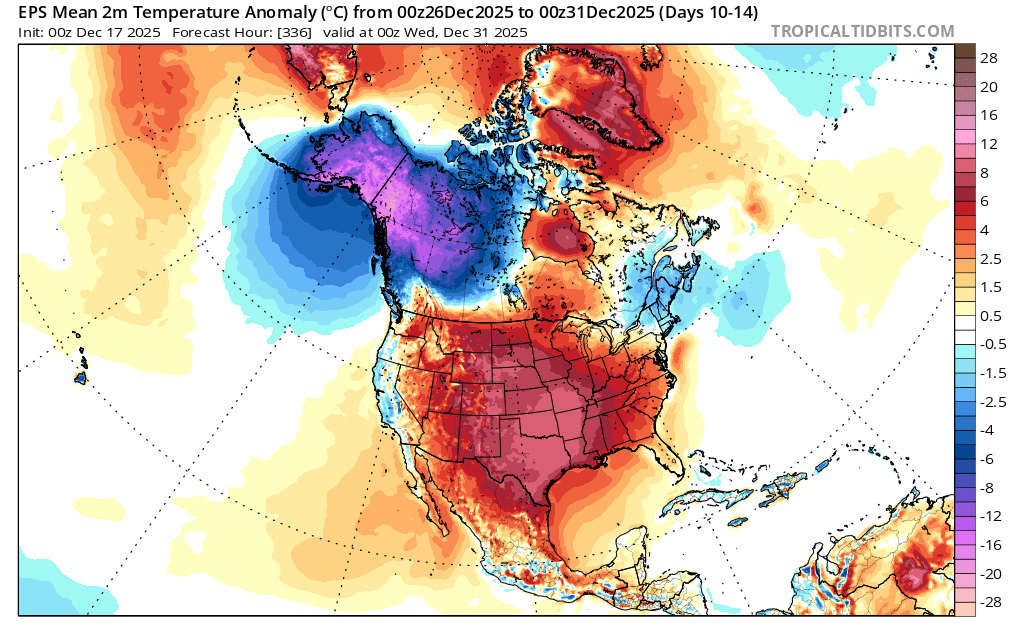
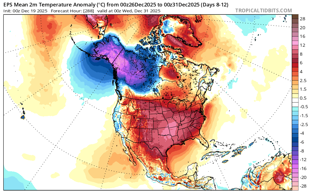
Just a brief note, the probability that the warmth will break through into the northern Mid-Atlantic and southern New England areas to close December has increased in recent days. The widespread warmth elsewhere in much of the CONUS and cold in NW Canada and Alaska remain intact. The forecast EPO+/PNA- seems sufficiently strong to offset the combination of a neutral AO and negative NAO even into parts of the Northeast now. Previously, the EPO was forecast to be mainly negative for the close of December. EPS from Wednesday 0z: EPS from Today 0z:

-
Seems like very little rain so far IMBY. 0.15”?
-
.thumb.jpg.6a4895b2a43f87359e4e7d04a6fa0d14.jpg)
Central PA Winter 25/26 Discussion and Obs
Yardstickgozinya replied to MAG5035's topic in Upstate New York/Pennsylvania
Ohh, snap, that's looking pretty gnarly again -

Central PA Winter 25/26 Discussion and Obs
mahantango#1 replied to MAG5035's topic in Upstate New York/Pennsylvania
The snow on the ground is gone except for the piles that I created. -
Up to 41 in Westfield. About 2 to 3 otg are about to dissappear today, hopefully some will be back Tuesday
-

December 2025 regional war/obs/disco thread
weatherwiz replied to Torch Tiger's topic in New England
DDH with a 59 mph win gust at 5:10 (saw on RadarScope). Wonder if that’s legit -
Central PA Winter 25/26 Discussion and Obs
Yardstickgozinya replied to MAG5035's topic in Upstate New York/Pennsylvania
I definitely worded the beginning of my post incorrectly. The point that I was trying to make, is it'll be interesting to see if trainingtimes hrrr verifies, based on what's happened in western pennsylvania and the ohio valley. -
It's going to be an interesting hike through the Christmas light display at McCrays farm in South Hadley this afternoon! Maybe I'll actually get to see the long fabled back end snow lol
-
LOL you haven't learned yet that labeling almost anything as "toxic" IS toxic? Welcome to the 2020s
-
Heavy rain here this morning. 0.92" and still going.
-
December 2025 regional war/obs/disco thread
Damage In Tolland replied to Torch Tiger's topic in New England
I saw that lol -
Looks like BOx expanded HWW to the rest of SE MA like we talked about yesterday. Could be an interesting day around here.
-
LFG
-
53 outside. Temp rising faster than Kevin at bear week in Provincetown.
-
Nicer day yesterday than I expected, got to 7C/44.5F with some sun even peeking in the later aft hours. Lost a lot of snow. The rain started after dusk, in awe to find it was over 10mm/.4" of rain ugh. I just had it switch over to snow, roads look icy even before the flash freeze. WUN is showing xmas day around 3-5C and rain...
-
Central PA Winter 25/26 Discussion and Obs
Yardstickgozinya replied to MAG5035's topic in Upstate New York/Pennsylvania
0.5 scan out of pittsburgh was definitely showing some bite at the ground from that band.
-
Central PA Winter 25/26 Discussion and Obs
mahantango#1 replied to MAG5035's topic in Upstate New York/Pennsylvania
-
Central PA Winter 25/26 Discussion and Obs
mahantango#1 replied to MAG5035's topic in Upstate New York/Pennsylvania
Patiently waiting to see if this squall line will make it through my area. Was looking forward to a thunderstorm. - Today
-
May have a nice squall as secondary cold front comes through in SNE. Hi res shows it this evening.
-
AI models are cooler fwiw on the 23rd. Hope for that especially SoP.
-
Hope for 1-3 on the 23rd and somehow makes it through Christmas Eve night when it finally goes below 32. Other than that overnight runs meh. What a pattern.
-
Central PA Winter 25/26 Discussion and Obs
Yardstickgozinya replied to MAG5035's topic in Upstate New York/Pennsylvania