
All Activity
- Past hour
-
SPC and Upton and Mount Holly really dropped the ball this go around by not issuing Flood Watches this morning already several in south NJ and now in Central NJ Torrential downpour developed out of nowhere FFW from KPHI
-
He must be having the fire department hosing down his back yard due to missing out on the heavy rain the rest of shared.
-
Scroll back a few pages. We went over that yesterday.
-

Augdewst 2026: Summer's Last Stand
Damage In Tolland replied to Prismshine Productions's topic in New England
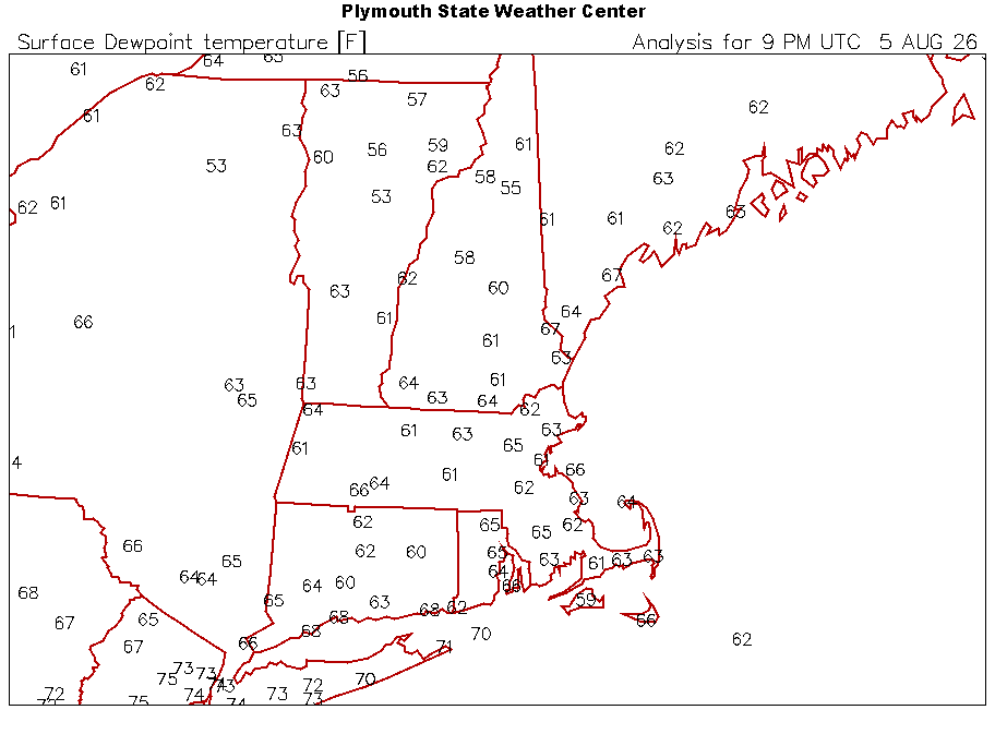
Now look at home stations -
Augdewst 2026: Summer's Last Stand
Damage In Tolland replied to Prismshine Productions's topic in New England
Where is here? -
Those posts were around 8am.
-

Augdewst 2026: Summer's Last Stand
dendrite replied to Prismshine Productions's topic in New England
-
E PA/NJ/DE Summer 2026 Obs/Discussion
Albedoman replied to PhiEaglesfan712's topic in Philadelphia Region
are you continuing your facebook /website too? -
My self-employed, work-from-home exemption card gives me a waiver down to 11:30am for up to 3 days per week.
-

Central PA Summer 2026 Discussion/Obs Thread
canderson replied to Voyager's topic in Upstate New York/Pennsylvania
Seems like a pretty big forecast whiff today -
Augdewst 2026: Summer's Last Stand
Damage In Tolland replied to Prismshine Productions's topic in New England
3:30 or so is acceptable for most -
.thumb.gif.f92b16c631a1d15d405ed77b33f0710d.gif)
Augdewst 2026: Summer's Last Stand
Torch Tiger replied to Prismshine Productions's topic in New England
Very nice. Looking forward to it -
Decent downpour here right now.
-
now pouring 10 - 15 miles east of you - going to be a warm humid night - I still expect Flood Watches in the near future
-

2026-2027 Record-breaking El Nino
bluewave replied to Stormchaserchuck1's topic in Weather Forecasting and Discussion
2020 was a really wild swing for the Arctic. We had the very strong polar vortex during the winter and a late season snow in early May. Then the warmest Arctic summer since 2012 with the Arctic sea ice almost as low. December had a 40” snowstorm in BGM followed by a record rainstorm and warm up on Christmas. -

Augdewst 2026: Summer's Last Stand
HIPPYVALLEY replied to Prismshine Productions's topic in New England
Well, it’s all relative. Being somebody who works at a brewery, anytime is acceptable really. But for most other professions, I’m going to roll with after 4 PM. -
You live in a special kind of hell. DP 62 here with a nice breeze.
-
Up to .20" on the day so far here.
-
 Well we had a 5030dm trough yesterday, and now models warm up the area north of Alaska to +250dm for several days. Really cold periods are reversing. Montana had snow in late June then it was an all time record high in Billings, MT, 111 degrees (beating their old all time record of 108) a few weeks later. DJF 25-26 was cold, then March 26 was record warm by the largest margin ever seen. I don't think the long term mean can really go very cold right now, but we may get periods of below average. Check out the correlation since 2012 though. 2019 was the warmest summer and then 19-20 was the coldest Winter of the period 60-90N.
 -

E PA/NJ/DE Summer 2026 Obs/Discussion
JTA66 replied to PhiEaglesfan712's topic in Philadelphia Region
Hope you’re cashing in when we’re under some SE pig ridge/-pna from hell regime! -
How early in the day is it acceptable to start though?
-
2026-2027 Record-breaking El Nino
bluewave replied to Stormchaserchuck1's topic in Weather Forecasting and Discussion
The pressures in general across the Arctic have been lower during the summers since 2013 with more ridging in the midlatitudes. There has been quite a bit of volatility in regard to the winter higher latitude blocking since the 13-14 winter. It’s been tough to hold a similar winter pattern across the Arctic for more than two winters in a row since 09-10. We actually have had the greatest degree of volatility from month to month and year to year since then. -
Pouring out in bridgewater even though radar isn't all that impressive looking
-
Precip is light here in Central NJ - its drying up as it moves north - but making the atmosphere much more humid Heat Advisories and T -storms next couple of days at least - sounds like fun.
-
Since 2017 the whole arctic (60-90N) is the leading indicator for Winter pattern 60-90N. It usually reverses.











