All Activity
- Past hour
-
Gotta save that yourself. I was expecting 2 inches and got 6 inches. Do you think anyone cares?
-
Harbaugh to the Giants
-

First Legit Storm Potential of the Season Upon Us
WinterWolf replied to 40/70 Benchmark's topic in New England
4Seasons showed it..it moved significantly west bro. Go back a couple posts. -
The UKIE, which has been the furthest east, was probably 150-200 miles west vs 12z.
-

First Legit Storm Potential of the Season Upon Us
dryslot replied to 40/70 Benchmark's topic in New England
Define shift? Because I see a couple tics possibly. -

First Legit Storm Potential of the Season Upon Us
The 4 Seasons replied to 40/70 Benchmark's topic in New England
right. and i think thatll give us an idea along with every other single piece of guidance what the ec/eps/ai will do, id be shocked if it were the same or worse. -
Does anybody have the model runs from the Jan 2021 storm?? For some reason i remember the foothills showing 2-3 inches and we ended up with 7 plus due to a similar scenario. .
-
I want to believe.
-
I just got off the phone with snowman19. He lowkey thinks it's coming.
-

First Legit Storm Potential of the Season Upon Us
Spanks45 replied to 40/70 Benchmark's topic in New England
Nice looking lows southwest of the center....been fooled by the GEFS recently, so will take it for now -
First Legit Storm Potential of the Season Upon Us
WinterWolf replied to 40/70 Benchmark's topic in New England
The takeaway was the shift though. Which was significant on that run. -
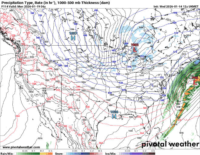
Model Roundup before the king’s turn: GFS: boom run, huge trends west and more precip. Eastern areas at risk of missing out UK: too far east but pretty nice looking storm CMC: finally has the storm, but too warm pretty much anywhere south of VA RGEM: has storm, too warm SE of 85 ICON: has storm but just too far east. Much improved from previous runs
-

First Legit Storm Potential of the Season Upon Us
WeatherGeek2025 replied to 40/70 Benchmark's topic in New England
give us that and everyone will be happy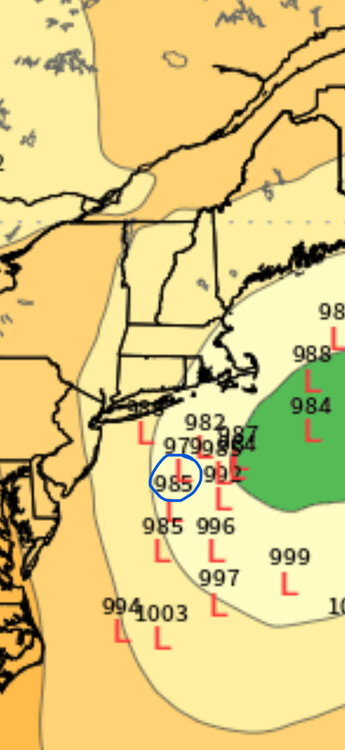
-

2025-2026 Fall/Winter Mountain Thread
Boonelight replied to Buckethead's topic in Southeastern States
Flurries in Deep Gap, nothing to really speak of. No accumulation. 30.7º Not expecting much out of this one. Sunday was a great surprise with almost an inch, but I don't think we will overperform this time, radar looks weak coming in from the west. -
First Legit Storm Potential of the Season Upon Us
dryslot replied to 40/70 Benchmark's topic in New England
Looks like crap but who cares it’s the ukie.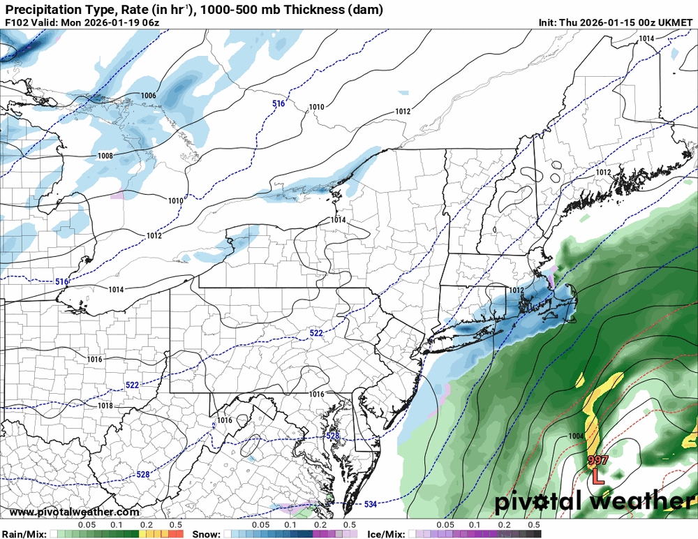
-
First Legit Storm Potential of the Season Upon Us
WinterWolf replied to 40/70 Benchmark's topic in New England
Ok, ya that was a big jump there. Thanks for the visual. -

Central PA Winter 25/26 Discussion and Obs
Blizzard of 93 replied to MAG5035's topic in Upstate New York/Pennsylvania
It will be fascinating to watch this unfold in the next couple of days. Hopefully the Euro takes another positive step tonight. -
First Legit Storm Potential of the Season Upon Us
The 4 Seasons replied to 40/70 Benchmark's topic in New England
-

First Legit Storm Potential of the Season Upon Us
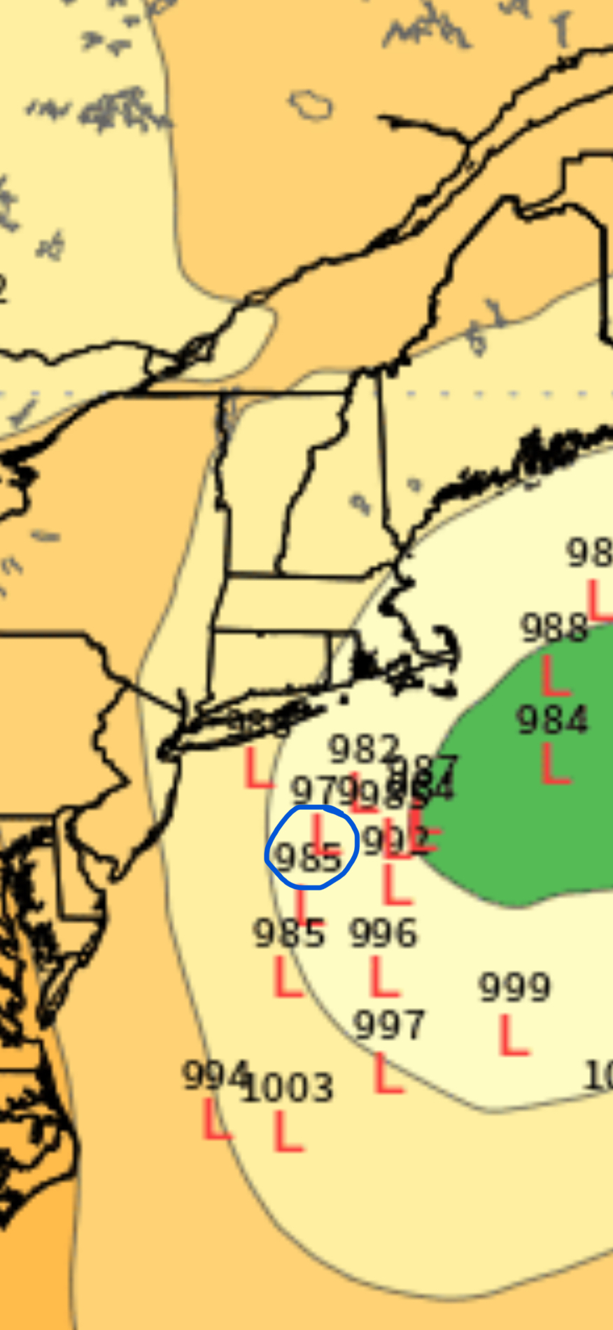
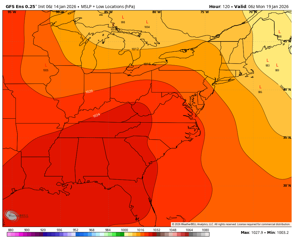
ORH_wxman replied to 40/70 Benchmark's topic in New England
GEFS individual lows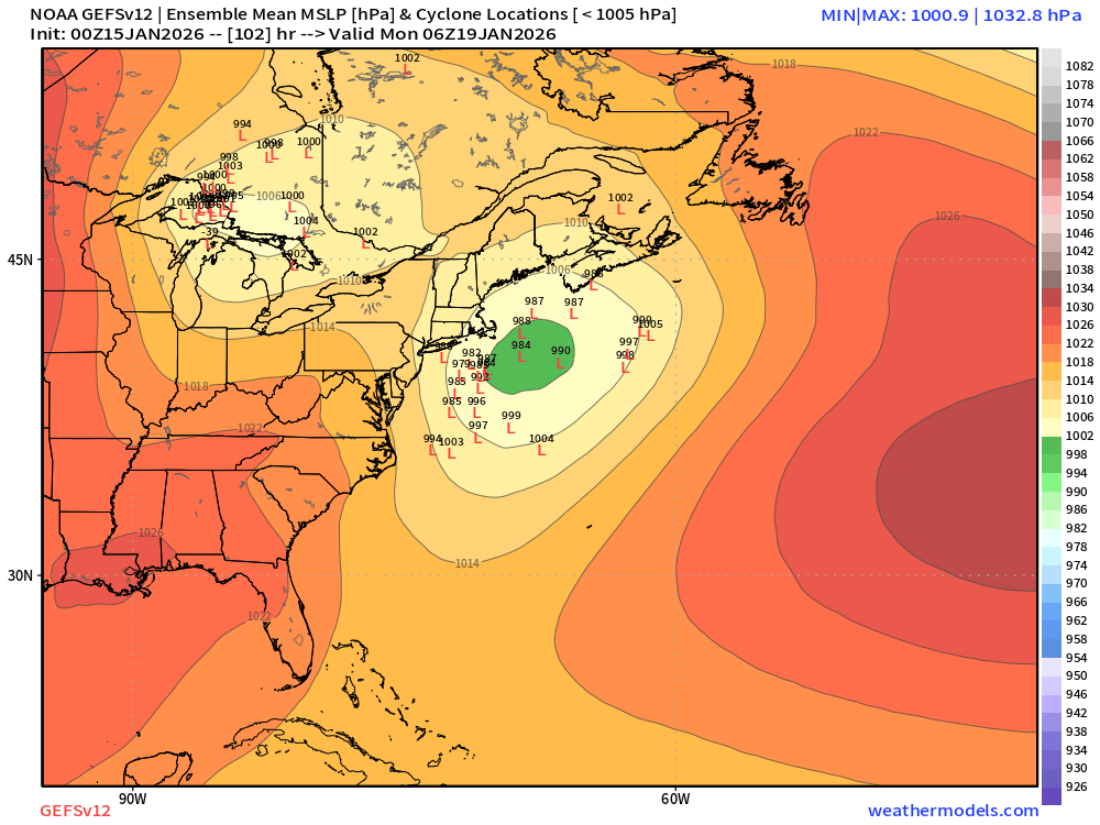
-
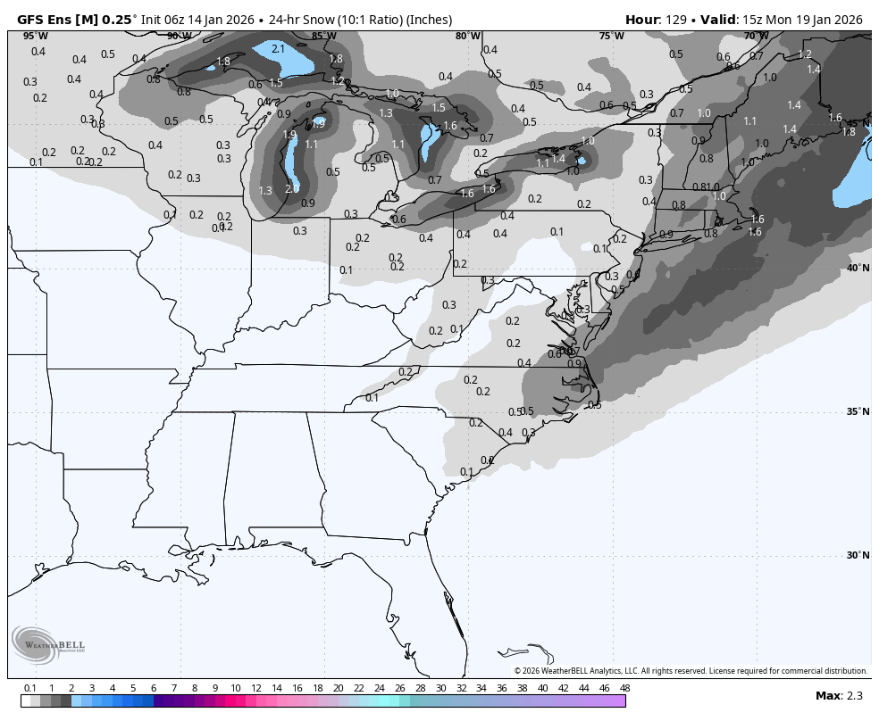
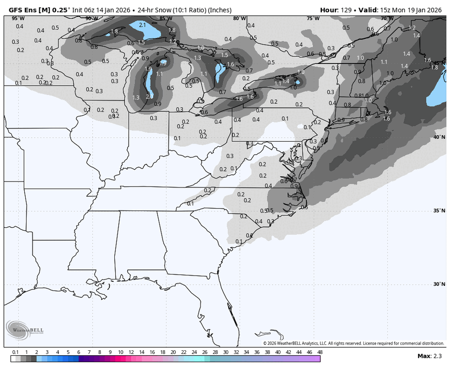
Storm potential January 18th-19th
WeatherGeek2025 replied to WeatherGeek2025's topic in New York City Metro
i want gfs 12z but 50 miles west! this one is for @snowman19 -

First Legit Storm Potential of the Season Upon Us
8611Blizz replied to 40/70 Benchmark's topic in New England
They are both right though. I t did come way west -
First Legit Storm Potential of the Season Upon Us
The 4 Seasons replied to 40/70 Benchmark's topic in New England
well both can be true. ill show you in a sec -
First Legit Storm Potential of the Season Upon Us
ORH_wxman replied to 40/70 Benchmark's topic in New England
Ukie was still mostly a miss. Scraper. But it was better than 12z. -
First Legit Storm Potential of the Season Upon Us
The 4 Seasons replied to 40/70 Benchmark's topic in New England
GEFS looks great, heres the 00Z trend 4-cycles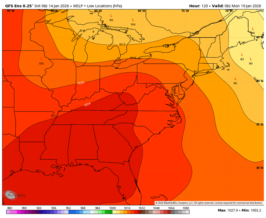
-
First Legit Storm Potential of the Season Upon Us
WeatherGeek2025 replied to 40/70 Benchmark's topic in New England
the europeans have lost the weather forecasting plot since the euro update years ago and gfs taking king since nemo in my opinion! Euro models will whiff and be stubborn while good models like gfs and cmc will hit and probably expand its precip shield by another 50-100 miles by making a bm track and making the storm stronger to around 985-990 millibars. i think anybody north west of Yarmouth and up to Worcester and west of Montauk up to Poughkeepsie is getting a dumping.