All Activity
- Past hour
-

2026-2027 Super El Nino
Stormchaserchuck1 replied to Stormchaserchuck1's topic in Weather Forecasting and Discussion
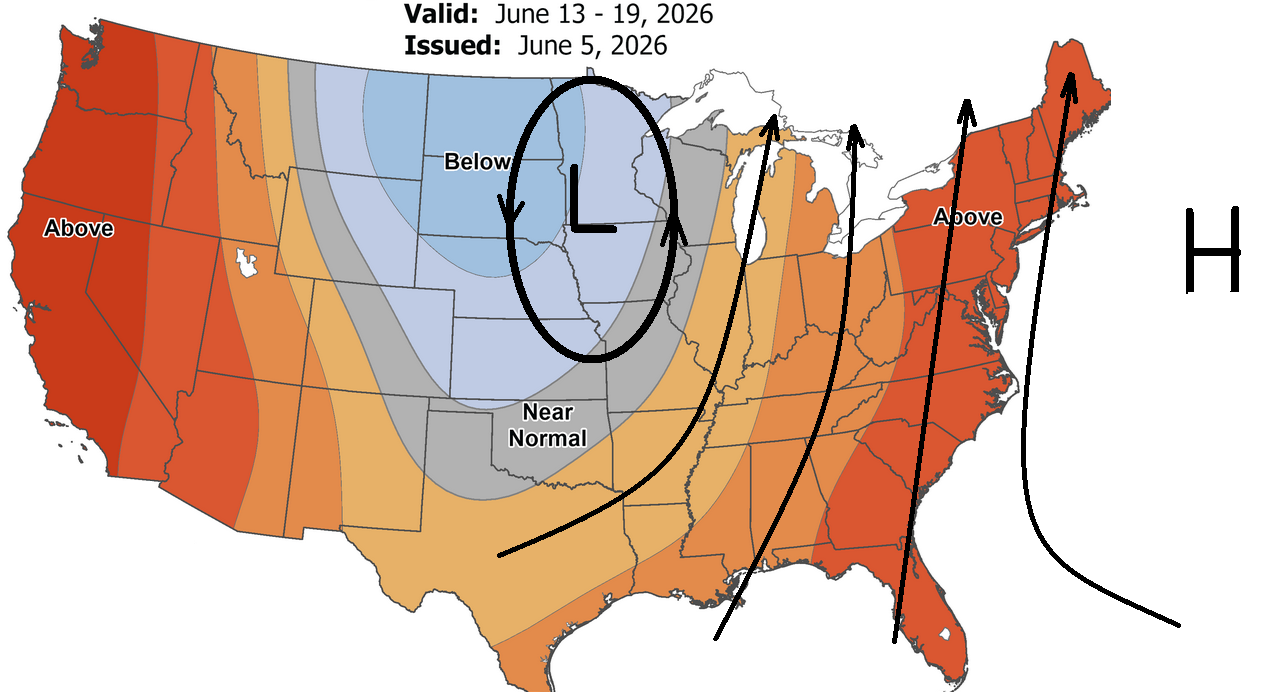
Euro and CANSIPS completely different over the EPO domain for the Winter. -
Just some added info. Dr. Mel Goldstein (who passed away in 2012?) developed a Severe Weather Index in the 1970's that was used to gauge severe weather potential in SNE. The index ranged from 1 to 5; 1 little or no severe wx potential, 5 was strong potential for tornadoes. He worked closely with region electricity suppliers to gauge the threat for power outages. In his morning update on October 3rd his index came in as 5!!! He issued updates during the day indicating the tornado potential was high, and in fact called the Office of Emergency Management several times about his concern. As a side note, I was living on the western edge of the Farmington Valley then, and observed obvious large scale low-level rotation racing northeast about 10 to 15 minutes prior to touchdown in Windsor Locks.
-
88-89F here. Not too bad with low humidity.
-

2026-2027 Super El Nino
40/70 Benchmark replied to Stormchaserchuck1's topic in Weather Forecasting and Discussion
Yea, that's how I feel. I don't see it showing up in the seasonal mean like the CANSIPS implies, but probably periods of it, especially in the 2nd half. -
@weatherwiz go to Brooks BBQ, a few extra pounds on you will make spiders more fearful !!
-
Same, granted mostly wooded areas
-
90 earlier, 88 now
-
Thank you so much for this. I’ve often wondered what the day was like elsewhere
-
Yeah but the humidity made it unbearable.
-
Oneonta is our target area for tomorrow!
-
Ahead of the tornadoes, communities across the region were battered by massive hailstones, with baseball-sized hail reported in multiple towns. Cape Cod experienced vivid, continuous lightning for nearly three hours that evening
-
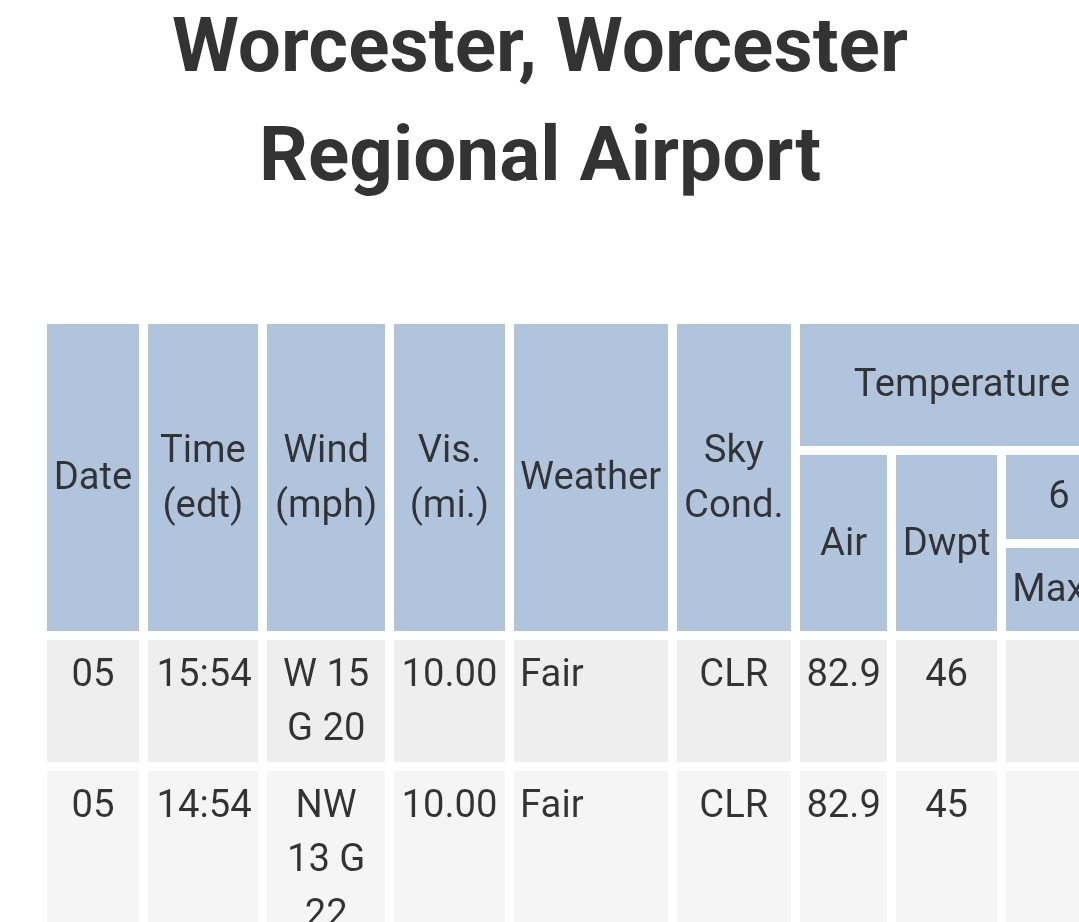
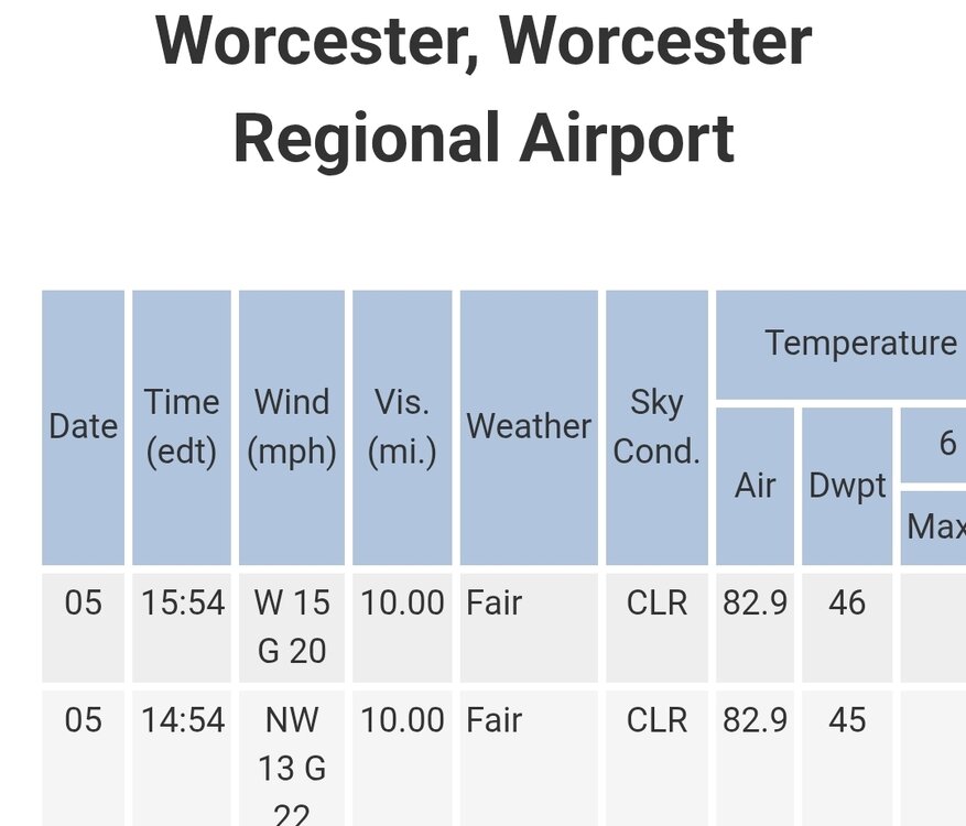
Did Bradley even hit 90 during the past 3 days?
-
Were there a lot of thunderstorms around locally the day of the Worcester tornado? I thought I read somewhere Boston got a strong thunderstorm later that same afternoon.
-
yeah. not here. I'm wonderin if there was a spray thing I don't know about. But I was over in Sterling at Meadow Brook, basically a 1000 acres of orchards, open fields, with woody glades doing disc golf last weekend and there wasn't one. Then I was over at Qual Ridge in Acton doing a regular golf there and again...none. Why is massachusett special
-
Max 84.0° Beautiful day. Didn’t even have to use my AK.
-
50th high school reunion tomorrow late afternoon into evening.. outdoors.. so count on rain on the South Hadley area..
-
They’ve been absolutely brutal here the past few days
-
(002).thumb.png.6e3d9d46bca5fe41aab7a74871dd8af8.png) Below is the Chester County PA area daily climate records for June since 1893. Also below is the June warmest high temperatures by state. Of note 32 states set their June record highs before 1960 this is similar to here in Chester County where 26 of our 30 June daily record highs all occurred prior to 1960.
Below is the Chester County PA area daily climate records for June since 1893. Also below is the June warmest high temperatures by state. Of note 32 states set their June record highs before 1960 this is similar to here in Chester County where 26 of our 30 June daily record highs all occurred prior to 1960.
- Today
-
and then it breaks down right when the MDR cane season's scheduled to begin ...
-

Junorch obs and discussion 2026
Damage In Tolland replied to Damage In Tolland's topic in New England
Should be the common theme for summer pattern with ridge EC and trough upper Midwest -
Junorch obs and discussion 2026
Damage In Tolland replied to Damage In Tolland's topic in New England
Deep deep Not 2 days ago they had 60’s Sun- Tues -
The lawns in Weymouth will be thankful.
-
Ok. I haven't looked in detail satellite loop for 10/3/1979. On 7/10/1989, sunrise in ern MA was clear and cool (60 F). Warm front tstms moved through by mid-morning, and then it stayed high OVC after in the warm sector.
-
Bring on the 75F dews
-
possible broadly defined/quasi Bahama Blue pattern setting up ?


.thumb.gif.f92b16c631a1d15d405ed77b33f0710d.gif)