All Activity
- Past hour
-
100 degrees in NYC in February! Woo hoo!
-
Yes, I think most of the winds on the latest recon were just about 70kt, if a bit more, and then surface winds should be lower than flight level, by 10 kt. I think the continued pressure of about 978mb supports relatively the same as this morning's recon, which may have had a bit of 75-80kt flight level.
-
 https://sierramedsrx.shop/# mexican rx
 -
https://indocureglobal.shop/# pharmacy website
-
Dewpoints in the upper 50s over SE TX which might as well be the Egyptian desert. If it's ramping up it has to now or very soon-because that's gonna hurt.
-
whatever that was or wasn't, okay. but that above is probably a record challenging warm blast clear to moose dung
-
And not over yet....maybe we should wait until after this winter to retire the NAMs...
-
i think this will be a pretty active thread bc of el nino this season
-
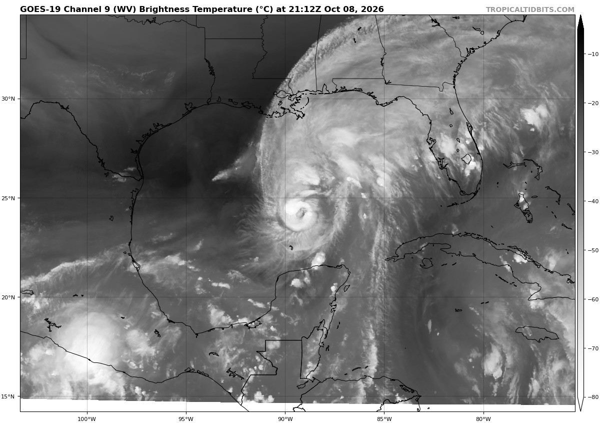
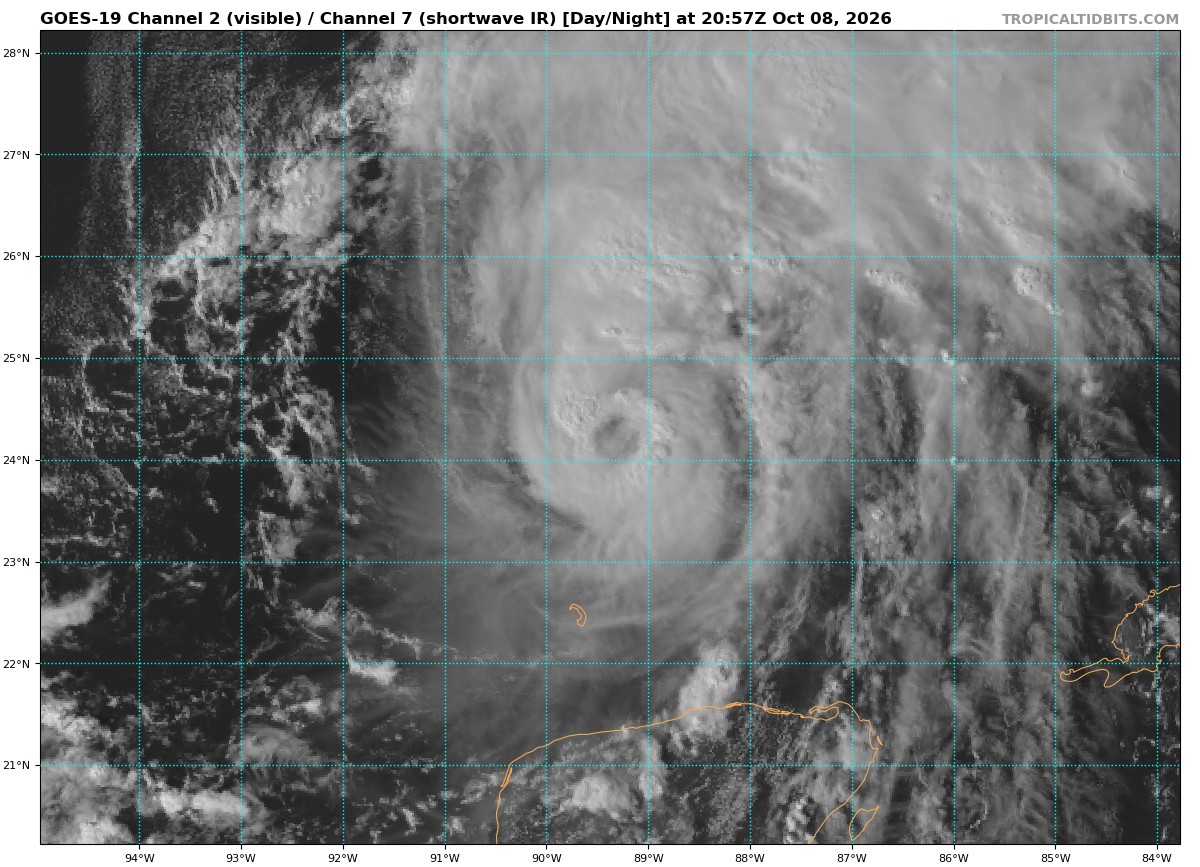
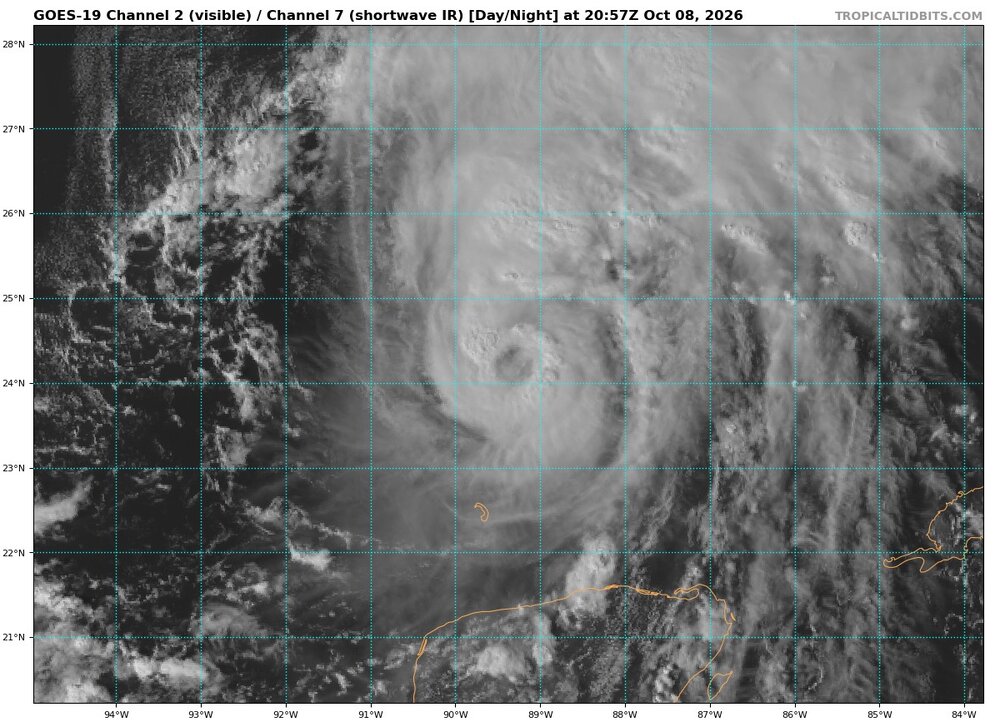
Very impressive ring of convection developing around the…. Eye…. Yes we have a legit eye now! Appears to be making another leap
-
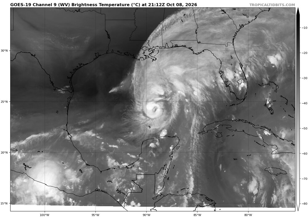
For scale, I attached zoomed out WV image,. The CDO/core of Isaias is very small. That makes it much more susceptible to shear and dry air. Also, easier RI. The 12z HAFS A/B shows sig intensification, but the rate of weakening it shows just in the last 9 hr up to landfall is quite remarkable. Just from a wild extreme swing one end to the other, this may be an exceptional event meteorologically. We get lots of big RIs just before landfall (Michael, Otis), but going the other way? I know no Atlantic situation quite like this, at least for an impending landfall. Sure, many HUs elsewhere has got torn apart in short order, but it is so much different when close to landfall and the system is quite strong within say 12-15 hr of landfall. A lot more eyes are on it!
-

Winter 2026-2027 Digital Snow Thread
Scarlet Pimpernel replied to SnowenOutThere's topic in Mid Atlantic
Dafuq?!?!?! And, given the late October timeframe, this would fall under the "plain ridiculous" category (but still kinda fun to look at)!! -

Brownsville Experiences Hottest September on Record
donsutherland1 replied to donsutherland1's topic in Climate Change
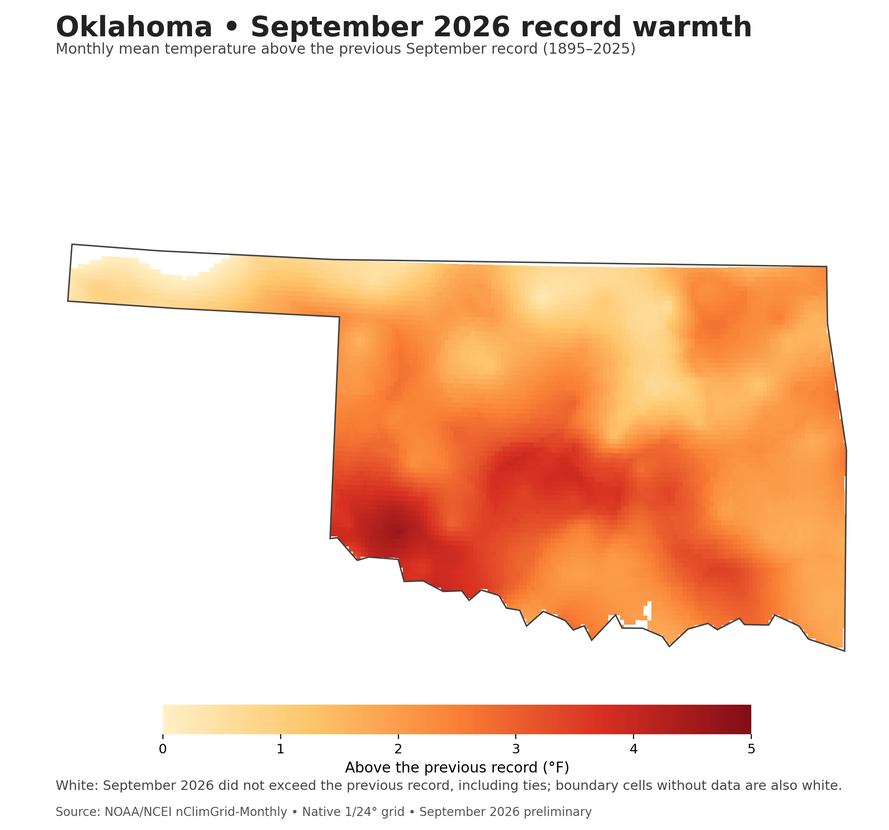
Oklahoma also destroyed its old record. September 2026: 82.8° (old record: 80.1°, 1931). Virtually all of the state exceeded its prior monthly record.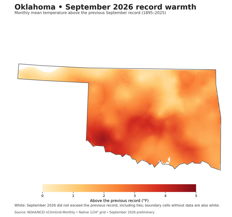
-
They are reaching IMHO. No drop in pressure and FL winds the same? That tail radar measurement I bet was due to pulsing convection transitory spot wind, rather than true gradient. And the Dvorak does not support 85 kt winds. One observation does not take precedence over several observations that show the contrary. I just find if they can hedge higher for system threading land, they will.
-
FL supported 80 kts but they noted tail Doppler found slightly higher winds around them enough to justify the increase. With organization once again looking better there’s nothing to argue why further increases wouldn’t be expected tonight as well
-
lol
-
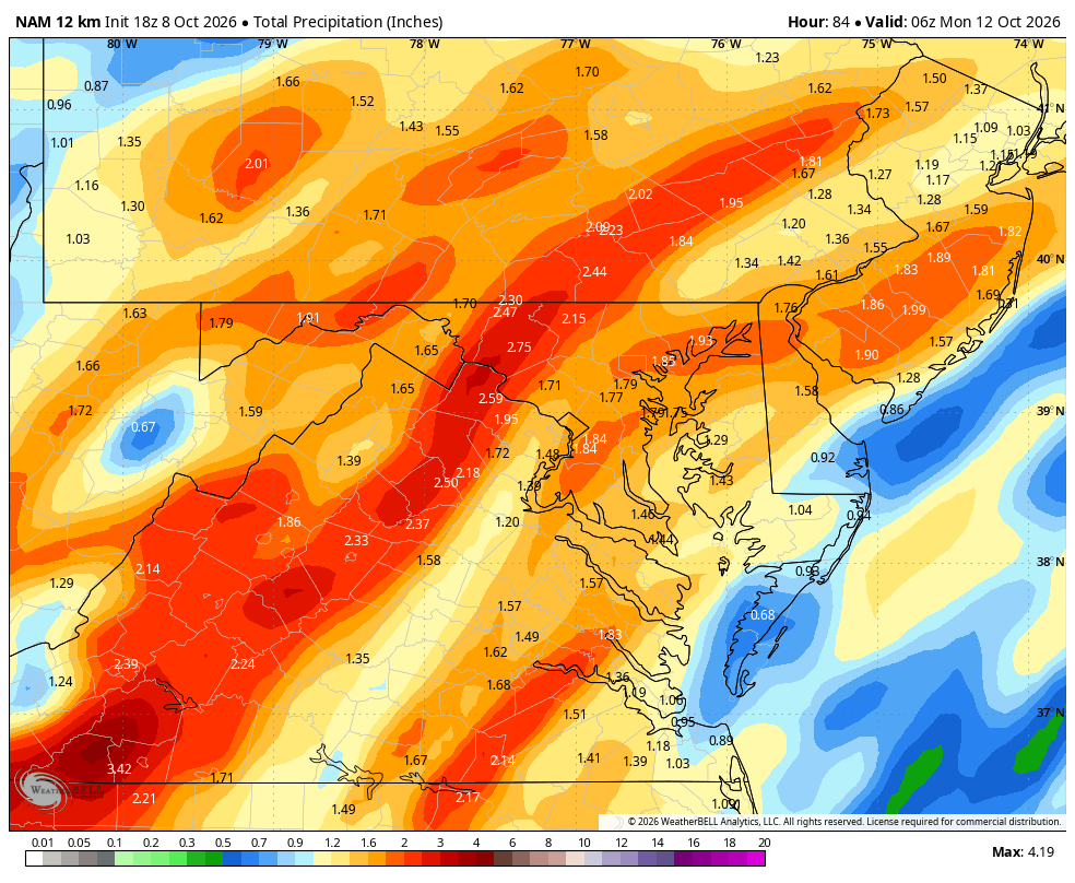
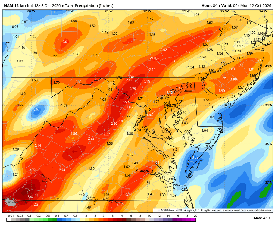
18z NAM suggest 1-3 inches region wide on Sunday
-
I feel like asking NHC if those 100 mph winds are in the room with them right now...
-
This happened w/ HU Lili in Oct 2002. It ramped up very quickly over the loop current, but once exiting, it weakened even faster in short order. 90 > 125 kt in 24 hr and then 125 > 80 kt in 24 hr at landfall. And the environment for LIli was not nearly as baroclinic w/ a lot of dry air/shear present as Isaias now. 20021002, 0000, , HU, 23.0N, 85.7W, 90, 967, -999, -999, -999, -999, -999, -999, -999, -999, -999, -999, -999, -999, -999 20021002, 0600, , HU, 23.6N, 87.2W, 100, 962, -999, -999, -999, -999, -999, -999, -999, -999, -999, -999, -999, -999, -999 20021002, 1200, , HU, 24.4N, 88.3W, 110, 952, -999, -999, -999, -999, -999, -999, -999, -999, -999, -999, -999, -999, -999 20021002, 1800, , HU, 25.4N, 89.5W, 120, 941, -999, -999, -999, -999, -999, -999, -999, -999, -999, -999, -999, -999, -999 20021002, 2013, I, HU, 25.9N, 89.9W, 125, 938, -999, -999, -999, -999, -999, -999, -999, -999, -999, -999, -999, -999, -999 20021003, 0000, , HU, 26.7N, 90.3W, 125, 940, -999, -999, -999, -999, -999, -999, -999, -999, -999, -999, -999, -999, -999 20021003, 0600, , HU, 28.1N, 91.4W, 105, 957, -999, -999, -999, -999, -999, -999, -999, -999, -999, -999, -999, -999, -999 20021003, 1200, , HU, 29.2N, 92.1W, 80, 962, -999, -999, -999, -999, -999, -999, -999, -999, -999, -999, -999, -999, -999 20021003, 1300, L, HU, 29.5N, 92.2W, 80, 963, -999, -999, -999, -999, -999, -999, -999, -999, -999, -999, -999, -999, 10
-
As I said, it'll hit Cat 3 before landfall.
-
I was not expecting 100 mph at this advisory especially with little to no change in pressure. Isaias is looking better on satellite now. Tonight probably best chance to overperform with that warm eddy and diurnal favorable timing for intensification before shear starts to offset everything.
-
Not a bad looking storm at all!
- Today
-
Eye has continued to develop and clear. Looks like a Cat 1-2 hurricane, which is what it is
-
The Nino is going to accelerate the warming to a degree no one has ever seen.
-
Hurricane Isaias Discussion Number 9 NWS National Hurricane Center Miami FL AL092026 400 PM CDT Thu Oct 08 2026 The eye of Isaias has become apparent on visible and infrared satellite imagery. Interestingly, this is the first eye noted on satellite pictures in the Atlantic basin during the 2026 Hurricane Season. The cloud tops have mostly warmed in the system, but the latest subjective Dvorak classification value from TAFB has increased to T4.5 or 77 kt. NOAA Hurricane Hunter aircraft observations do not indicate a drop in central pressure so far and the peak 700-mb flight-level winds have not increased. However, Tail Doppler Radar wind velocities from the aircraft measured just above the surface support increasing the intensity to 85 kt for this advisory. Satellite and aircraft center fixes indicate that the hurricane appears to have made its expected turn toward the northeast and the initial motion is now 050/10 kt. Isaias is expected to turn northward tomorrow and move between a mid-level ridge extending westward from the Bahamas to the Florida peninsula and a trough near the northwest Gulf Coast. On the forecast track, the center will move inland along the northern Gulf coast within the next 36 hours, and then pass over portions of the southeastern U.S. during the next few days. The official forecast is nudged slightly eastward and follows the latest corrected consensus model guidance. The intensity forecast remains somewhat problematic. The hurricane will be passing over Gulf waters of high oceanic heat content during the next day or so. In fact, the projected track of Isais shows it passing near a warm eddy overnight. However, the vertical wind shear, which is already significant, is expected to increase substantially during the next 36 hours. The current thinking is that the shear will not offset the conducive oceanic conditions until 12-24 hours, so further strengthening is anticipated overnight. The official intensity forecast is at the high end of the model guidance, but in consideration of the expected stronger wind shear in 24-36 hours, some decrease in intensity is indicated as Isaias approaches the coast. Regardless, Isaias is expected to remain a dangerous hurricane through landfall, and strong gusty winds are expected well inland after the center crosses the coast. Key Messages: 1. A life-threatening storm surge is expected from the Mouth of the Mississippi River to Suwannee, Florida. Residents in the warning area should follow advice given by local officials and evacuate immediately if told to do so. 2. Damaging hurricane force-winds are expected over portions of the Florida Panhandle, southern Alabama, and southern Mississippi where a Hurricane Warning is in effect. Residents in these areas should prepare for the possibility of long-duration power outages. 3. Damaging wind gusts are possible over much of central and northern Alabama, extreme eastern Mississippi, and portions of western and northern Georgia, especially in areas of higher terrain. Additional Tropical Storm and High Wind Watches and Warnings may be required for portions of that area later tonight. Residents should secure loose outdoor items, avoid driving high-profile vehicles, and prepare for power outages. 4. Isaias will bring areas of heavy rainfall to the central U.S. Gulf coast and much of the Southeast Friday into the weekend. Considerable flash and urban flooding, along with significant river flooding, will be possible. FORECAST POSITIONS AND MAX WINDS INIT 08/2100Z 24.4N 89.3W 85 KT 100 MPH 12H 09/0600Z 25.7N 88.4W 95 KT 110 MPH 24H 09/1800Z 28.2N 87.4W 85 KT 100 MPH 36H 10/0600Z 31.0N 87.2W 65 KT 75 MPH...INLAND 48H 10/1800Z 33.2N 87.8W 30 KT 35 MPH...INLAND 60H 11/0600Z 35.0N 87.8W 25 KT 30 MPH...POST-TROP/INLAND 72H 11/1800Z 37.0N 85.0W 20 KT 25 MPH...POST-TROP/INLAND 96H 12/1800Z...DISSIPATED $$ Forecaster Pasch
-
BULLETIN Hurricane Isaias Advisory Number 9 NWS National Hurricane Center Miami FL AL092026 400 PM CDT Thu Oct 08 2026 ...HURRICANE HUNTERS FIND THAT ISAIAS NOW HAS 100 MPH WINDS... ...PREPARATIONS TO PROTECT LIFE AND PROPERTY FROM STORM SURGE AND DAMAGING WINDS IN THE WARNING AREA SHOULD BE RUSHED TO COMPLETION TODAY... SUMMARY OF 400 PM CDT...2100 UTC...INFORMATION ---------------------------------------------- LOCATION...24.4N 89.3W ABOUT 215 MI...345 KM N OF PROGRESO MEXICO ABOUT 325 MI...525 KM S OF THE MOUTH OF THE MISSISSIPPI RIVER MAXIMUM SUSTAINED WINDS...100 MPH...155 KM/H PRESENT MOVEMENT...NE OR 50 DEGREES AT 12 MPH...19 KM/H MINIMUM CENTRAL PRESSURE...975 MB...28.80 INCHES