All Activity
- Past hour
-
 What are your thoughts in terms of winds interior and coast ?
 -

Strong Nor'Easter/Hybrid Storm Late September 2026
wthrmn654 replied to Rjay's topic in New York City Metro
18zeuro shifted east a little but no where near the gfs icon and euro very similar except with euro it comes on shore over east end then goes west ward and essentially rots away and then clears out at some point. We're getting closer to an idea but still not there yet. -

October Comes Early: Late September Multi-Hazard Hybrid Storm
vortex95 replied to WxWatcher007's topic in New England
Partially correct. Nothing like this in Sep for a Nor'easter! -
October Comes Early: Late September Multi-Hazard Hybrid Storm
vortex95 replied to WxWatcher007's topic in New England
No you don't! -
Breezy, temp remained in the upper 40s most of the day and fog/drizzle from sunup to sundown. Mother Nature took note of yesterday's calendar, jeez. 6.21" of rain this month so things in the ground are at least happy.
-
Tomorrow will be another variably cloudy day. Highs should reach the middle and upper 60s. Some periods of rain and showers are possible late Friday through the weekend. The extent of the precipitation will depend on the track of a developing storm. For now, the system looks to pass far enough from the region to produce lighter to moderate amounts of precipitation in the immediate New York City area. Coastal erosion and some flooding at high tide appears likely. Long Island, especially Suffolk County, could experience gusty winds with some periods of heavy rain. Uncertainty still exists in terms of track and timing. Temperatures will remain unseasonably cool through the weekend with highs mainly in the lower and middle 60s. The ENSO Region 1+2 anomaly was +4.6°C and the Region 3.4 anomaly was +3.0°C for the week centered around September 16. For the past six weeks, the ENSO Region 1+2 anomaly has averaged +4.33°C and the ENSO Region 3.4 anomaly has averaged +2.73°C. Both ENSO regions have tied their all-time warmest anomalies. The ongoing strong El Niño, will continue to strengthen through the mid-fall. The SOI was -12.06 today. The preliminary Arctic Oscillation (AO) was +0.757 today. Based on sensitivity analysis applied to the latest guidance, there is an implied near 67% probability that New York City will have a cooler than normal September (1991-2020 normal). September will likely finish with a mean temperature near 68.5° (0.7° below normal). Supplemental Information: The projected mean would be 0.5° above the 1981-2010 normal monthly value.
-
 canadian pharmacies: Сan Am Cross Care - canada rx pharmacy world
 -
Strong Nor'Easter/Hybrid Storm Late September 2026
wthrmn654 replied to Rjay's topic in New York City Metro
I'm glad I'm in my happy place bubble avoiding that nonsense then. Atleast nyers are crazy but sane. Can't say the same about the jersey people coming up with that nonsense. -
October Comes Early: Late September Multi-Hazard Hybrid Storm
vortex95 replied to WxWatcher007's topic in New England
Concerning the E Coast storm development and possible ST development... I wanted to share my thoughts and throw this out there for food for thought. @weatherwiz, has the below crossed you mind? @ineedsnow will be like "BRING IT ON!" as to subtropical development. @CoastalWxwill just be "MEH" b/c it makes zero difference in Weymouth! Sometimes in forecast meteorology you have to think proactively in the abstract at times for those potential outlier events, otherwise you can get "caught behind the 8-ball," playing catch-up and making excuses. This current E Coast storm situation reminds me a bit of Sandy's situation, except reversed! A non-tropical low possibly becoming ST near the E Coast and how can it be handled. I know of no cases where an ET low warm secluded and became a ST storm near the Mid-Atlantic or New England coast. Yes, the Perfect Storm in 1991 did this, and so did the Oct 2021 biggie (Wanda later), but those TCs formed way E out to sea after the local ET storm impacts had gone. Not the same when you have ongoing ET low impacts on land, and then the low transitions to a ST storm and gets a name! I may be reaching a bit here, but I think this particular storm situation warrants some added attention. ECMWF and UKMET suggest ST transition is possible off the Mid-Atlantic or New England coast. Clear warm core to 500 and SSTs easily are in range. Phase diagrams show a fairly good symmetric warm core. NHC does not even mention it on their 7-day TWO? I find this a bit odd. Many, many times they will put in something even if the slightest chance of ST development for systems like this. Just b/c it is close to the coast and may cause confusing in messaging is irrelevant to the met science! It is what it is. You can't pick and choose. Yes, I know it's not so simple as to how things work overall, but that does not make me wrong in this context. In this age of social media, do you want ppl calling you out as to "this thing is clearly ST, and yet nothing from NHC". Not good PR. It is even more precarious in this case. Why?, I can not recall a nor'easter this strong for the E Coast in Sep, so SSTs are near climo peak, and they are 2-4 C above avg S of New England. Extraordinary/outlier patterns can lead to extraordinary/outlier events, and we have the knowledge/skill to fcst such much better now, and so should use it. I've seen NHC highlight baroclinic systems in the subtropical EPAC that have no chance of development and give it 0/0, and also in the Atlantic many times, so again, don't tell me there is not anything here to outlook. If anything, it is more important due to proximity to the coast. Thoughts? -
https://canamcrosscare.shop/# canada pharmacy store
-
In the warm section here. High was 79 and humid. Only picked up .02" today.
-
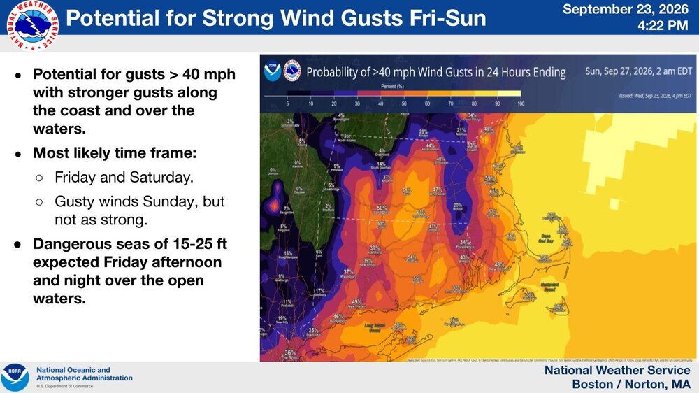
Here it comes . Keep ramping her up . Can see that dead zone in E Ma up into S NH in lowland downslope
-
2026 Atlantic Hurricane Season
vortex95 replied to Stormchaserchuck1's topic in Tropical Headquarters
Concerning the E Coast storm development and possible ST development... I wanted to share my thoughts and throw this out there for food for thought. Sometimes in forecast meteorology you have to think proactively in the abstract at times for those potential outlier events, otherwise you can get "caught behind the 8-ball," playing catch-up and making excuses. This current E Coast storm situation reminds me a bit of Sandy's situation, except reversed! A non-tropical low possibly becoming ST near the E Coast and how can it be handled. I know of no cases where an ET low warm secluded and became a ST storm near the Mid-Atlantic or New England coast. Yes, the Perfect Storm in 1991 did this, and so did the Oct 2021 biggie (Wanda later), but those TCs formed way E out to sea after the local ET storm impacts had gone. Not the same when you have ongoing ET low impacts on land, and then the low transitions to a ST storm and gets a name! I may be reaching a bit here, but I think this particular storm situation warrants some added attention. ECMWF and UKMET suggest ST transition is possible off the Mid-Atlantic or New England coast. Clear warm core to 500 and SSTs easily are in range. Phase diagrams show a fairly good symmetric warm core. NHC does not even mention it on their 7-day TWO? I find this a bit odd. Many, many times they will put in something even if the slightest chance of ST development for systems like this. Just b/c it is close to the coast and may cause confusing in messaging is irrelevant to the met science! It is what it is. You can't pick and choose. Yes, I know it's not so simple as to how things work overall, but that does not make me wrong in this context. In this age of social media, do you want ppl calling you out as to "this thing is clearly ST, and yet nothing from NHC". Not good PR. It is even more precarious in this case. Why?, I can not recall a nor'easter this strong for the E Coast in Sep, so SSTs are near climo peak, and they are 2-4 C above avg S of New England. Extraordinary/outlier patterns can lead to extraordinary/outlier events, and we have the knowledge/skill to fcst such much better now, and so should use it. I've seen NHC highlight baroclinic systems in the subtropical EPAC that have no chance of development and give it 0/0, and also in the Atlantic many times, so again, don't tell me there is not anything here to outlook. If anything, it is more important due to proximity to the coast. Thoughts? -
ok thank you for your careful analysis of the evolution of the current geopolitical situation in the middle east
-
.thumb.gif.f92b16c631a1d15d405ed77b33f0710d.gif)
October Comes Early: Late September Multi-Hazard Hybrid Storm
Torch Tiger replied to WxWatcher007's topic in New England
30mph gusts and a cold, pouring rain should require some drinks -

October Comes Early: Late September Multi-Hazard Hybrid Storm
dendrite replied to WxWatcher007's topic in New England
It's still inverted, but that's the strongest I've seen from any model at that level. -
canadian mail order pharmacy: СanAmCrossCare - cipa canada online pharmacy
-
Oh we know.
-

October Comes Early: Late September Multi-Hazard Hybrid Storm
kdxken replied to WxWatcher007's topic in New England
Funky Murphy's emergency GTG? Brunch? -

Strong Nor'Easter/Hybrid Storm Late September 2026
guinness77 replied to Rjay's topic in New York City Metro
People on Twitter are absolutely losing their minds. Lot of people going there for whatever the reason (clicks?). I saw a guy with a substantial amount of followers call it Sandy 2.0 and when he got called out on it he’s like “I’m just talking about the track,” which was false. This place is fairly rational which is why I read here for a long time before I signed up. -
October Comes Early: Late September Multi-Hazard Hybrid Storm
dendrite replied to WxWatcher007's topic in New England
The euro rips 60-70kt at 925 over ORH county Sunday morning. -
October Comes Early: Late September Multi-Hazard Hybrid Storm
kdxken replied to WxWatcher007's topic in New England
I can almost live with it if Taunton becomes part of Cape cod Bay.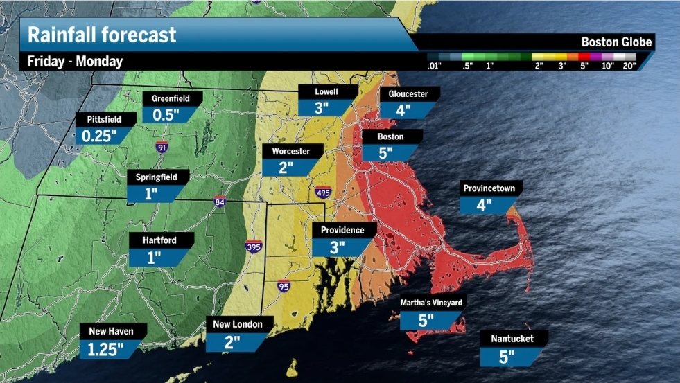
-
0.52 3 days of drizzle - first 3 inch month since May...
-

October Comes Early: Late September Multi-Hazard Hybrid Storm
WinterWolf replied to WxWatcher007's topic in New England
By 0z that jackpot will be over NYC…the takeaway…it’s gonna rain quite a bit this weekend it seems. -
October Comes Early: Late September Multi-Hazard Hybrid Storm
kdxken replied to WxWatcher007's topic in New England
It had better not
.thumb.JPG.418e8a9a2902ae687ec35ff4bc0e038e.JPG)