All Activity
- Past hour
-
But what does the Navy say? Oh wait, it hasn't run since Thanksgiving. Guess it's hibernating for now. Good runs overall tonight, AI models as well. Big moves, good moves. MJO- No Access to MA? What happened, they banned you in the Mid Atlantic forums?
-
Icon well south now
.thumb.png.f96902be125867ee073719e6b64bd3e7.png)
- Today
-
The quality of the snow at Tahoe may be improving slightly. Can't see the ground very well because of very heavy snow, lol. https://www.palisadestahoe.com/mountain-information/webcams I'm not saying it's piling up. It probably isn't. It's probably 37 degrees up there at 8200 feet. Pac puke is strong medicine. It is going to rule the Sierra all winter. But I am hoping so hard just for them. I want those guys to get lots of it because they so badly need to get that resort going big time. It costs tons of money just to keep a ski resort running, let alone hopefully turn a profit, and brown ground for Christmas won't help them.
-

Winter 2025-26 Medium/Long Range Discussion
HillsdaleMIWeather replied to michsnowfreak's topic in Lakes/Ohio Valley
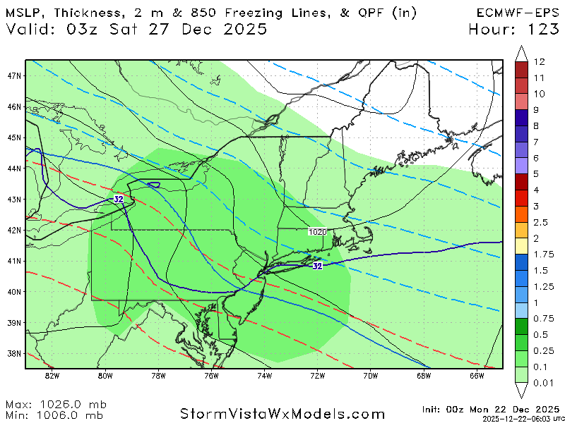
Euro also has pretty widespread freezing rain up to the border, definitely something to watch -
Would've loved to see more of the 0z Euro... but it almost alludes to what BAM said regarding the big storm for the first week of January.
-

E PA/NJ/DE Winter 2025-26 Obs/Discussion
LVblizzard replied to LVblizzard's topic in Philadelphia Region
0z models are looking VERY interesting for Friday-Saturday. If that blocking trends just a little stronger some of us could be in for a pretty significant snow or ice storm. -

Winter 2025-26 Medium/Long Range Discussion
SouthOaklandCtyWX replied to michsnowfreak's topic in Lakes/Ohio Valley
The cutoff between 6+ inches of snow and nothing is pretty sharp too. -
yes and since its multiple models trending that way and its only 5 days away chances are good we will have at least some sort of frozen event - still way too early for details..........
-
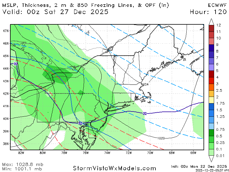
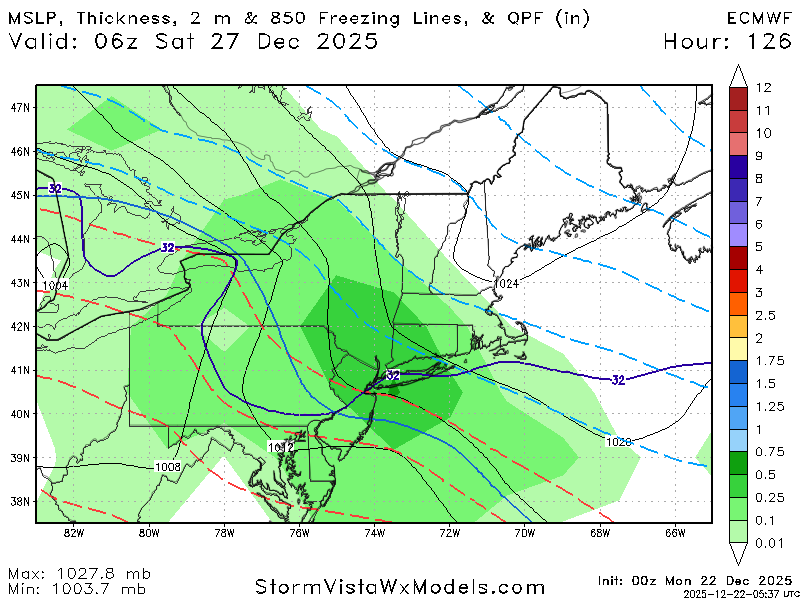
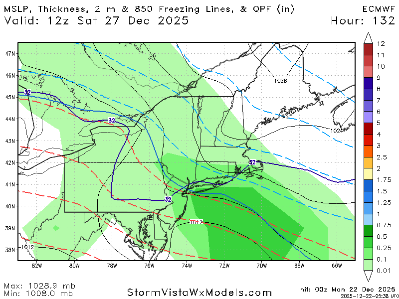
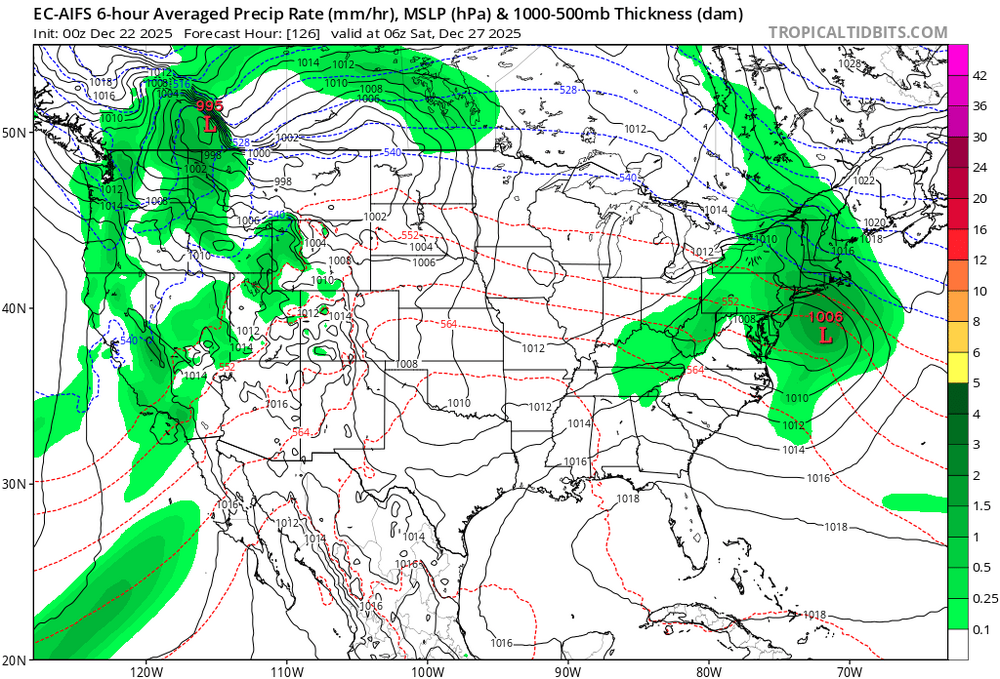
0z Euro and GFS are advertising some ZR for our northern crew on 12/26-27. It has ticked south a lot over the last 24 hours... maybe they can tick again?
-
Yep. Now the eps is also south. Looks like the models latched on to the blocking tonight.
-
agreed and its only 5 days away....
-
Its further south like the other models. Good trends tonight.
-
The problem with the Euro is that HP in Canada is not holding in place compared to the GFS - the LP is allowed to move further north
-
Winter 2025-26 Medium/Long Range Discussion
HillsdaleMIWeather replied to michsnowfreak's topic in Lakes/Ohio Valley
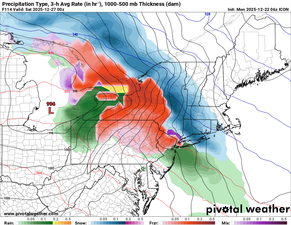
0Z GFS is wanting to utterly nuke Grand Rapids to Detroit with an ice storm the day after Christmas -
Several inches This is getting interesting
-
have a snow map?
-
That’s not just a cold shot though. That’s a 500mb map with a clear trend toward a stronger, more west based ridge (+PNA) and a trough forming in the east. Block is establishing etc. That being said… still very far out so it’ll change 50x. Grain of salt yada yada
-
Euro !
-
Euro south


-
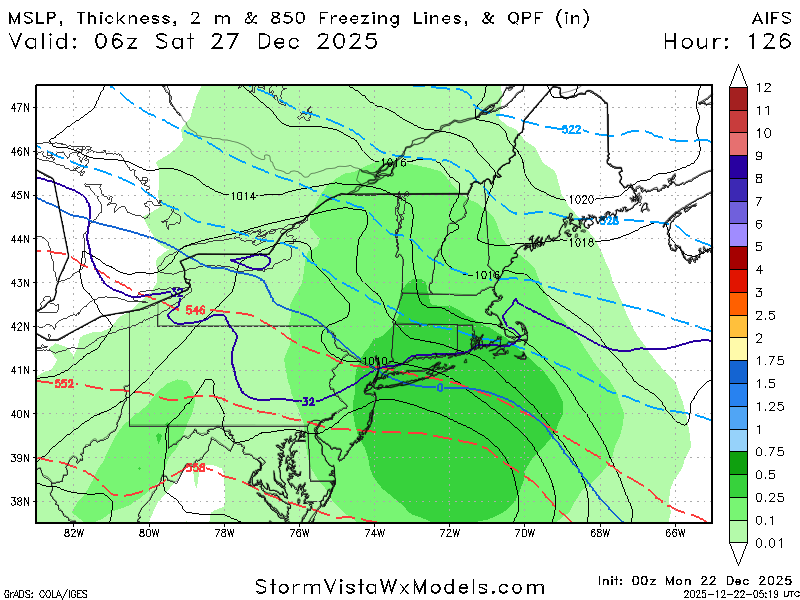
AI euro is south for next week
-
00z ecmwf ai is also south snow to rain.
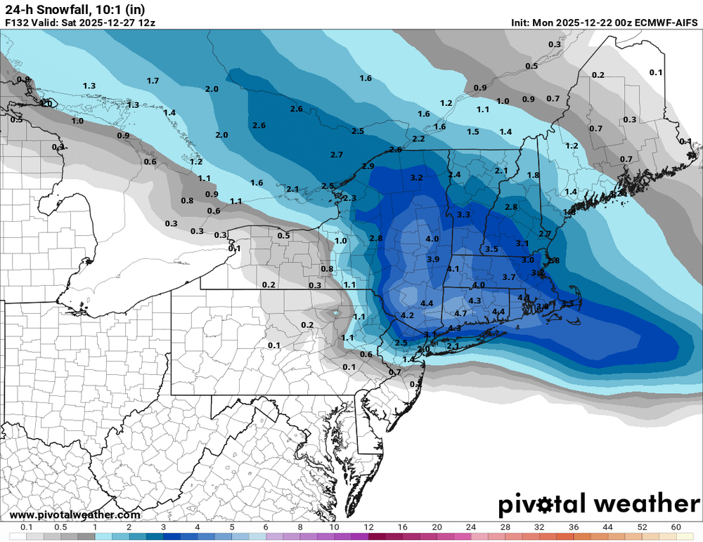
-
IF's And's or But's -all involving where that HP is in southeast Canada and the strength of it throughout the event- pattern is changing back into a colder one along with more blocking developing
-
.thumb.png.4150b06c63a21f61052e47a612bf1818.png)
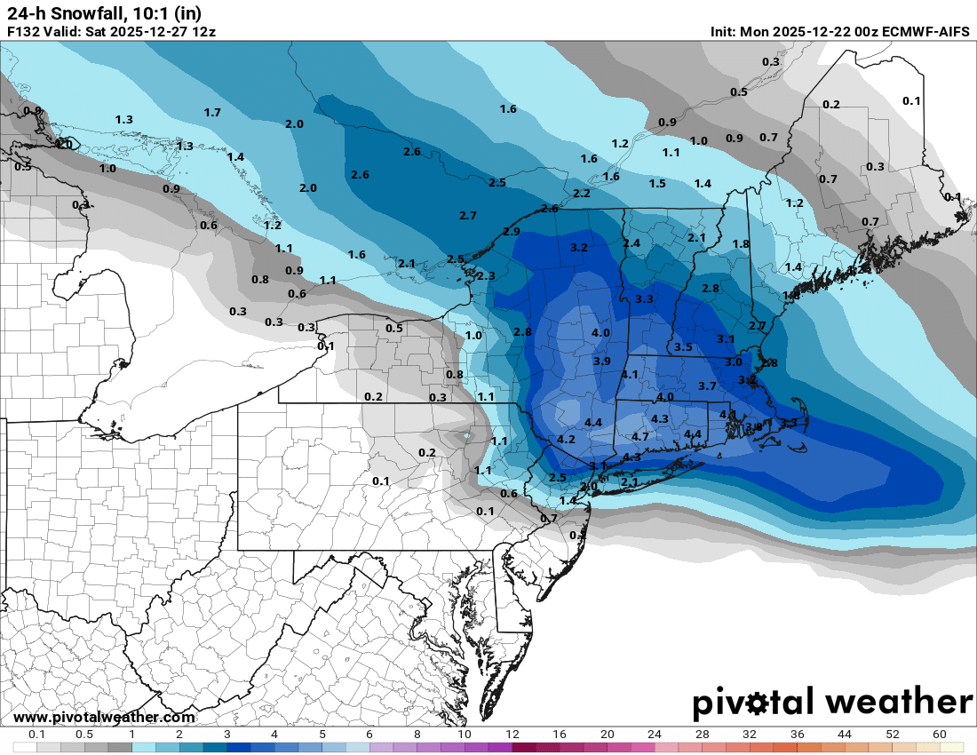
December 2025 regional war/obs/disco thread
HIPPYVALLEY replied to Torch Tiger's topic in New England
Those totals will shift around a bunch this week but good to see something on most models. -
I think it's fair to say that in the last 24 hours this potential storm has become more interesting and that if trends continued it could open up the possibility of a mostly frozen or even a mostly snow event Friday. But there's a lot of *ifs* there. WX/PT
-
May be the beginning of models moving toward analogs