All Activity
- Past hour
-
Still can’t believe some of us went from two feet of snow to a cold rain in 12 hours.
-

January 2026 regional war/obs/disco thread
Modfan2 replied to Baroclinic Zone's topic in New England
Down to -2F in E CT, hard to believe it will be in the 30’s today. -
I know why we failed: we believed in snow maps actually showing snow in the NC foothills. That should have been the first red flag models were out to lunch
-

January 2026 regional war/obs/disco thread
mahk_webstah replied to Baroclinic Zone's topic in New England
When I woke up to pee and saw all the pages I knew. WPC is a little skeptical though Mirage? So how confident are we in this trend, and will it continue or revert back to earlier runs, is the big question. Given the nearly unanimous trend in this direction, and at least a couple model runs in a row showing such a trend, it does seem like this shift has some merit. However, overall run to run consistency has shown pretty large swings with the exact handling of both the southern and northern stream energy. Suspect that the exact details of these features is far from settled upon...especially the northern stream energy which is currently strung out across much of western Canada into the arctic. Thus tend to think that the unanimous model trend could be a slight mirage and suggests more confidence in a solution than there actually is at this point. Either way, it should be stressed that in just about every outcome we get a widespread and major winter storm with many areas getting significant impacts regardless of these exact details. These details are, however, important for exactly where the maximum snow and ice totals occur. The current WPC QPF and temperatures were derived before much of this 00z guidance was available, and thus is a bit south of the new consensus. As described above, no guarantee we dont see a shift back south in later models...but assuming some persistence in the 06z/12z models then the WPC update today would likely shift north to at least some extent. -

January 25-26 Winter Storm Potential
susqushawn replied to Ralph Wiggum's topic in Philadelphia Region
Icon liking the more amped solution at 6z.thumb.gif.17b7afbeec2feefefeae7c579ad2fc89.gif)
-
And show HAS to be falling
-
After what just transpired for this weekend I don’t even know why tracking from more than 3 days out is even worthwhile
-
Wait until February 2nd before starting one.
-
We can start it on January 31st. Thats the minimum now. .
-
Anyone wanna start a thread for the February 2 storm??
-
Honestly, I hope this system continues trending north and just goes completely away. I want 70 and sunny if it’s not gonna snow.
-

January 25/26 Jimbo Back Surgery Storm
NorthHillsWx replied to Jimbo!'s topic in Southeastern States
Sadly, why this is happening is easy to explain. Models have been moving the trough further and further west for two days. What that does is twofold: dumps cold air further west and leads to an earlier and full capture of the Baja low. Result is an earlier phase, and the SER can flex again with the trough axis to the west. This is textbook coastal fail mode for the SE. The surprising thing to me is simply how poorly this was modeled. We’re talking a 500 mile shift since yesterday morning. With very good blocking setting up, I’m still somewhat skeptical of this cutting straight into the high, but we’re walking a fail line between ice and rain at this point if these solutions are realistic with the NS trough axis. I did not think I’d see a Baja low phase in Texas 24 hours ago but that’s what the modeling consensus shows us -
ICON at 6z joins the more amped camp, out thru 102 with heavies over most of the sub and a low down in the south. It’s going to be a huge hit, but will review uppers. Phase occurring a lot fair west earlier/cleaner than prior runs.
-
It can’t get any worse.
-
January 25/26 Jimbo Back Surgery Storm
NorthHillsWx replied to Jimbo!'s topic in Southeastern States
Webb throwing up the white flag https://x.com/webberweather/status/2013860089803804790?s=46&t=NyKvXvI1o-sJQb-68mmo4g -
I’m too afraid to see.
-
Antone know how the overnight models runs went?
-

January 25-26 Winter Storm Potential
dseagull replied to Ralph Wiggum's topic in Philadelphia Region
Thats an awfully strong HP, touting 1040mb or even slightly higher. I think all noteworthy models have a handle on how quickly is departs, and the extent of the arctic air. But is the Euro picking up on this transfer correctly? What data was ingested to show such a massive correction north? The Baja low? -

January 25/26 Jimbo Back Surgery Storm
LakeNormanStormin replied to Jimbo!'s topic in Southeastern States
Said as well as anyone could say. 0.50 inches of ice messes me up. -
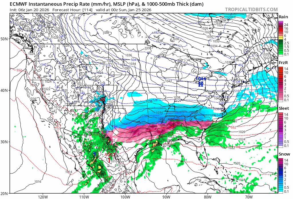
To put this into perspective, the ECMWF trend north the last four runs.
-
January 25/26 Jimbo Back Surgery Storm
NorthHillsWx replied to Jimbo!'s topic in Southeastern States
Some of the trends on the EURO are the most stunning reversals I have ever seen. Parts of north Georgia have gone from the mid 20s to the mid 60s in 4 runs. It’s the king, but that is hard to take in. I am very skeptical the wedge just evaporates. -
Just got the chance to look at the 0z suite... Wow, there's your north trend and then some. Now that it seems increasingly possible you aim the intense WAA snows over the region, the entire evolution and storm is a bit different. I know the global models are showing a solid 18-24 hour storm, but from experience you usually only get 12-15 hours at most from a WAA thump until you dry slot. If I were to be super picky and extra HECS hunter, that would be what I'm not a fan of. But hey, if the Euro is right and you throw 1.25" QPF into an air mass with surface temps in the upper single digits and lower teens, as well with localized 700 fgen, easily crank out a few hours of 2-3+ in/hr rates. Also, this could be an overreaction from the models with the shift north, we'll just have to see. But I do think if you want a true long duration event, you want to play the balance between getting into the WAA snows and the backside ULL/coastal that develops as the storm departs.
-
January 25/26 Jimbo Back Surgery Storm
NorthHillsWx replied to Jimbo!'s topic in Southeastern States
We have now crossed the line where the storm mode has changed. We won because energy was sliding under a 1040 mb high. This is now a super amped coastal. Even the big cities north of us are at risk of mix now if this is the case, like any nor Easter, BAM was right… That being said, be wary of the wedge eroding this fast, that’s a 1040, not a 1026 sitting in prime CAD position. EURO notoriously scours the wedge too quick. While hope for a snowstorm is fading and probably the least likely outcome for anyone on the board, I don’t see a way around a 2002-like ice event somewhere in the Carolina’s. Do not let your guard down, this can be a memorable storm, but for ALL the wrong reasons. What a freaking nightmare of a hobby -

MO/KS/AR/OK 2025-2026 Winter Discussion
JoMo replied to stormdragonwx's topic in Central/Western States
Winter Storm Watches now out for Southern KS and Southern MO. -
January 25/26 Jimbo Back Surgery Storm
LakeNormanStormin replied to Jimbo!'s topic in Southeastern States
NAM isn't great. But not terrible. Someone said look north of DFW. Sleet where we want snow. Not the trend the early crew wants.