All Activity
- Past hour
-
Smoke plume thickest at this time in our area, but moving out in WV., so maybe some improvement later in the day, certainly once the winds shift to SW tomorrow. week. close up here https://www.star.nesdis.noaa.gov/GOES/sector_band.php?sat=G19§or=ne&band=GEOCOLOR&length=24
-
Third morning in a row that IAD gets down into the 40s. 47F for the low this AM.
-
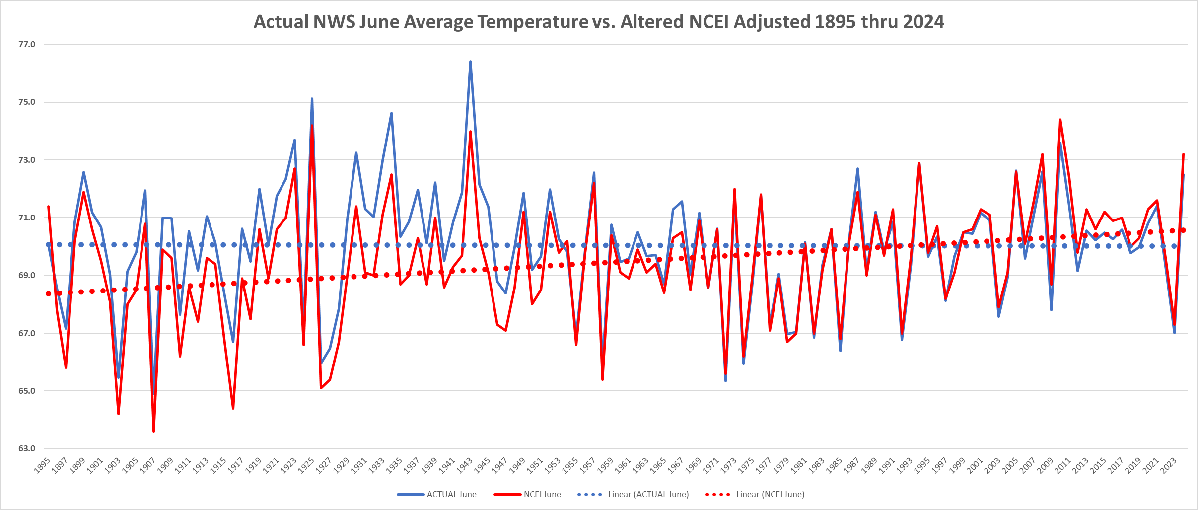
 Below is the June Actual National Weather Service Average June Average Raw Data Temperature vs. NOAA/NCEI Altered Temperature Data. Of note without the altered data June's here in Chester County have a slightly cooler trend line. After applying the adjustments we return to a warming trend. Funny how it always works that way.....
-
37.8 this morning. Glad to see there's a decent shot of another deluge this weekend. It's every boy's dream to get more rainfall than Kuala Lumpur. Let's make June another 10" plus month. What the hell...
-
Below is the June Actual National Weather Service Average June Average Raw Data Temperature vs. NOAA/NCEI Altered Temperature Data. Of note without the altered data June's here in Chester County have a slightly cooler trend line. After applying the adjustments we return to a warming trend.
-
E PA/NJ/DE Summer 2025 Obs/Discussion
ChescoWx replied to Hurricane Agnes's topic in Philadelphia Region
Below is the June Actual National Weather Service Average June Average Raw Data Temperature vs. NOAA/NCEI Altered Temperature Data. Of note without the altered data June's here in Chester County have a slightly cooler trend line. After applying the adjustments we return to a warming trend.
-
Pretty dense band of smoke over the eastern Lakes/upstate NY. We appear circumstantially protected for now but I’m wondering if that may get involved tomorrow …
-

2025-2026 ENSO
40/70 Benchmark replied to 40/70 Benchmark's topic in Weather Forecasting and Discussion
I was speaking of that winter in a NE US context, but it makes sense that it wasn't as bad in the GL region....that set up isn't as hostile there. -
So you're telling me there's not a cloud in the sky...but all of this overcast is wildfire smoke? Wow, lol
-

2025-2026 ENSO
TheClimateChanger replied to 40/70 Benchmark's topic in Weather Forecasting and Discussion
Nah, eastern Great Lakes. Still one of the snowiest Januarys on record in most areas, and like 90% of it fell in the first two weeks or so. I think we were out of school more than we were in school during that stretch. These don't even capture the fact that the big midwest blizzard brought a lot of freezing rain and sleet at the beginning of the month (1/2 to 1/3). So, yeah, that was a very impressive wintry stretch in an otherwise ho-hum winter. Erie - 4th snowiest January Buffalo - 3rd snowiest January Cleveland - 6th snowiest January Canton/Akron - 5th snowiest January Youngstown, Ohio - Snowiest on record -
That’s what I’m wondering … if/when the temp correlates. Maybe even how the particle physics works in that, but keeping it simple. … which circumstantially would also have dependency on accuracy for where the plumes will be located/density in time ….
-
I noticed those are the only ones that have the temperature jump.
-

2025-2026 ENSO
PhiEaglesfan712 replied to 40/70 Benchmark's topic in Weather Forecasting and Discussion
Yes, that's the list, though you could add 1972-73. -
2025-2026 ENSO
40/70 Benchmark replied to 40/70 Benchmark's topic in Weather Forecasting and Discussion
Yes, the winter overall sucked. You are in the mid atl, I assume? -
cloudy or sunny that day-- the lows were similar to 6-4-23 but the highs were lower
-
2015-16 even worse than 1982-83, same one big storm winter
-
2025-2026 ENSO
TheClimateChanger replied to 40/70 Benchmark's topic in Weather Forecasting and Discussion
The first half of January was rocking in my neck of the woods. Maybe overall it was warm, but we had storm after storm to start the year. Probably the best two week stretch other than February 2010. -
All I know is the HRRR models it and I believe is tuned to show how it affects temps.
-
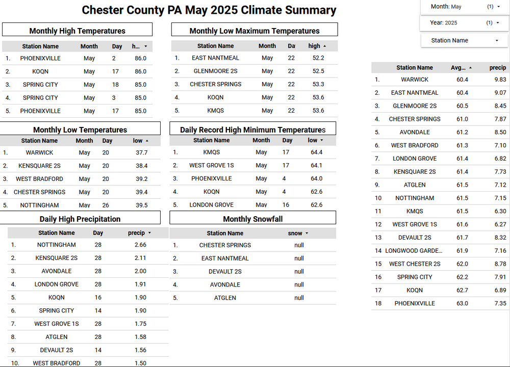
Below is the May Climate Summary for Chester County PA. We finished with a below average temperature of 61.5 our 30 year average May temperature is 61.9 degrees. This was the 61st chilliest May with 132 years of records. It was a very wet month with an average rainfall across the county of 7.70" this is the 4th highest average county rainfall since records began in 1894. The climate summary is detailed below with the warmest temperature at Phoenixville on May 2nd and the coldest at Warwick Township on May 20th.
-
E PA/NJ/DE Summer 2025 Obs/Discussion
ChescoWx replied to Hurricane Agnes's topic in Philadelphia Region
Below is the May Climate Summary for Chester County PA. We finished with a below average temperature of 61.5 our 30 year average May temperature is 61.9 degrees. This was the 61st chilliest May with 132 years of records. It was a very wet month with an average rainfall across the county of 7.70" this is the 4th highest average county rainfall since records began in 1894. The climate summary is detailed below with the warmest temperature at Phoenixville on May 2nd and the coldest at Warwick Township on May 20th.
-
6/3/1997 LGA 61 / 49 JFK: 62 / 50 NYC: 61 / 49 EWR:
-
what about super (+2) el ninos? I think only 1982-83, 1997-98, 2015-16 ?
-
38 and 39°F respectively here the last two days.
-
usually takes til mid June to get out of that season
-
Wet in the central plains, and southeast with the cut off low near Northern FL, GA, and the Carolinas this week, storms from the slow front get our area closer to the >1 inch Fri-Sat.