
All Activity
- Past hour
-
 I don't think the SE, US will be below average temps like a lot of historical analogs suggest
 -

2026-2027 Record-breaking El Nino
40/70 Benchmark replied to Stormchaserchuck1's topic in Weather Forecasting and Discussion
Yea, someone in the New England forum was trying to tell me were going to have a -PNA this winter...I was like, fine a super El Niño that pulled that off. -AO/+PNA means you can essentially eliminate the bottom dwelling seasons. -
 https://quickph.com/# online pharmacy without prescription
 -
Since the El Nino developed in April, it's been a clear mid-latitude ridging pattern under 90N +AO. That's been the dominant pattern - not anything coming from the Tropics I'm going to repeat this post, the pattern has been following itself closely, not anything in the historical analog dataset. Similarities to 2025 over the past 5 months: 2025 Apr-July 4/4 months -PNA 2026 Apr-July 4/4 months -PNA 2025 Aug +PNA 2026 Aug +PNA 2025 Apr-Aug 5/5 months +AO 2026 Apr-Aug 5/5 months +AO
-
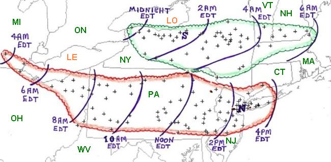
1 of 2 derechos that day. The 2nd one hit our area
-
July 22, 2011 had high end heat. A lot of records that day, including EWR's all-time high of 108.
-
2026-2027 Record-breaking El Nino
40/70 Benchmark replied to Stormchaserchuck1's topic in Weather Forecasting and Discussion
What I can tell you based on what has been happening for the past decade is that the error is likely to be guidance underestimating the scope and magnitude of that Canadian ridge, so it's probably safe to assume that the greater heights will extend further to the south and east than most guidance suggests.....which combined with the poor read on the Pacific makes me very suspicious of that trend to shove the lower heights northward on the CANSIPS. This isn't me saying awful winter....I don't think, or want that to be the case, but that doesn't mean that I'm going to don my Frosty the Snowman boxers every time that I post. -
several tornado warnings in NY/PA today
-

Monday, August 31 - Thursday, September 3, 2026 Convective Episodes
WxWatcher007 replied to weatherwiz's topic in New England
While we’re setting the O/U on audible thunder at 0.5 -
Labor Day 1998 https://www.cnyhistory.org/2014/09/labor-day-storm-1998/
-
I think Wx Twitter is going in circles because this will be the last Atlantic TC we see in a while.
-
2026-2027 Record-breaking El Nino
40/70 Benchmark replied to Stormchaserchuck1's topic in Weather Forecasting and Discussion
I don't know Wall, so I'll take your word for it. I think most on this board would agree that my only agenda is getting the forecast correct, and placing much stock into a model with such a poor initialization of the Pacific basin, both ENSO and extra tropical, gives me significant pause before seriously considering it's output. This isn't about CC, or how well the model did last year....it's about the fact that it has such an obviously poor read on the Pacific. -
Monday, August 31 - Thursday, September 3, 2026 Convective Episodes
WxWatcher007 replied to weatherwiz's topic in New England
Don’t look at western NY -

Monday, August 31 - Thursday, September 3, 2026 Convective Episodes
CoastalWx replied to weatherwiz's topic in New England
It’s funny how bad we are at convection. -
Monday, August 31 - Thursday, September 3, 2026 Convective Episodes
CoastalWx replied to weatherwiz's topic in New England
BGM didn’t even hit 70 today. So that kills Kevin’s argument. -

Monday, August 31 - Thursday, September 3, 2026 Convective Episodes
weatherwiz replied to weatherwiz's topic in New England
What a line and reactivity gradient. Holy smokes -
Monday, August 31 - Thursday, September 3, 2026 Convective Episodes
CoastalWx replied to weatherwiz's topic in New England
That’s not true I just explained why. They had storms in a WAA pattern despite SE winds. Now stein. -

Central PA Summer 2026 Discussion/Obs Thread
mahantango#1 replied to Voyager's topic in Upstate New York/Pennsylvania
Good lightning show to my north. -
Central PA Summer 2026 Discussion/Obs Thread
mahantango#1 replied to Voyager's topic in Upstate New York/Pennsylvania
.76 rain today. -
Central PA Summer 2026 Discussion/Obs Thread
mahantango#1 replied to Voyager's topic in Upstate New York/Pennsylvania
Here too, thought we were headed to dusk. -
I cannot believe all those folks around the league were wrong about Albernaz...and that this isn't growing pains. I mean he was quite sought after the previous off-season, and highly spoken of! I'm skeptical of the notion he'll never get better. He could very well be a great manager elsewhere if he gets fired here. But no matter how you slice it--getting fired after your rookie season with no chance to grow is humiliating to say the least. Gonna be interesting to see what happens.
-

Monday, August 31 - Thursday, September 3, 2026 Convective Episodes
Hoth replied to weatherwiz's topic in New England
Impressive event in upstate NY and PA for sure. -
79/62 today. Very nice day. Increasing rain chances coming up with a Lake breeze. Hopefully will do well in the precip dept.
-
 Binghamton is gonna gust 75+
 -
The N Atlantic kills us 9 times out of 10. Especially east of River









