All Activity
- Past hour
-
Wpc basically has the same view, perhaps a bit more optimistic. The possibility is there, but we’ve had a lot of those kinds of possibilities this year. I wouldn’t surprise me either way, but sometimes the ones that show big early on then come back again later.
-
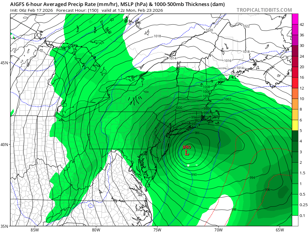
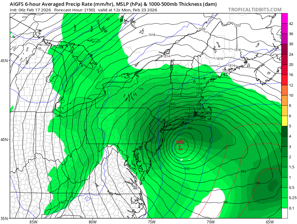
AIGFS with a nice hit, wish AI Euro would follow suit
-
I don’t like how the big hit look is going away. I can already see where this is going.
-
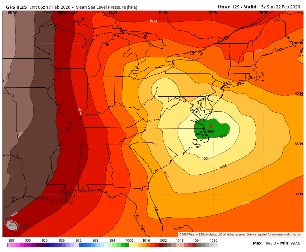
lol just saying what it has. Notice after hr 120 there was no comment from him. It’s close enough on guidance to certainly entertain. But right now consensus is offshore or a graze. Plenty of time for moves though.
-
An so begins the death-knell of winter '25-26.
-

Arctic Sea Ice Extent, Area, and Volume
Stormchaserchuck1 replied to ORH_wxman's topic in Climate Change
It's been 13 years since the last max.. You would think we would start moving toward loss exponentially again. Big difference has been cold 500mb and SLP over the Arctic in the warm season. Last strong High pressure Summer pattern was 2019. -
A classic one two punch. Needs with his optimistic probably inaccurate take pulls my head up then coastal gives me a hard jab and I’m down
-
GFS tickling its way to a EURO like solution?
-

E PA/NJ/DE Winter 2025-26 Obs/Discussion
Duca892 replied to LVblizzard's topic in Philadelphia Region
Believe tomorrow at 12z we are essentially at or slightly under 100hrs. -
Regular gfs is a solid hit for most big hit for Jersey…. AIGFS colder and solid
-
E PA/NJ/DE Winter 2025-26 Obs/Discussion
Duca892 replied to LVblizzard's topic in Philadelphia Region
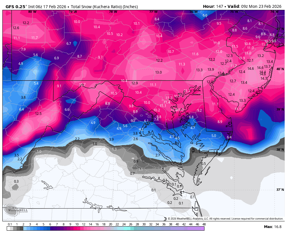
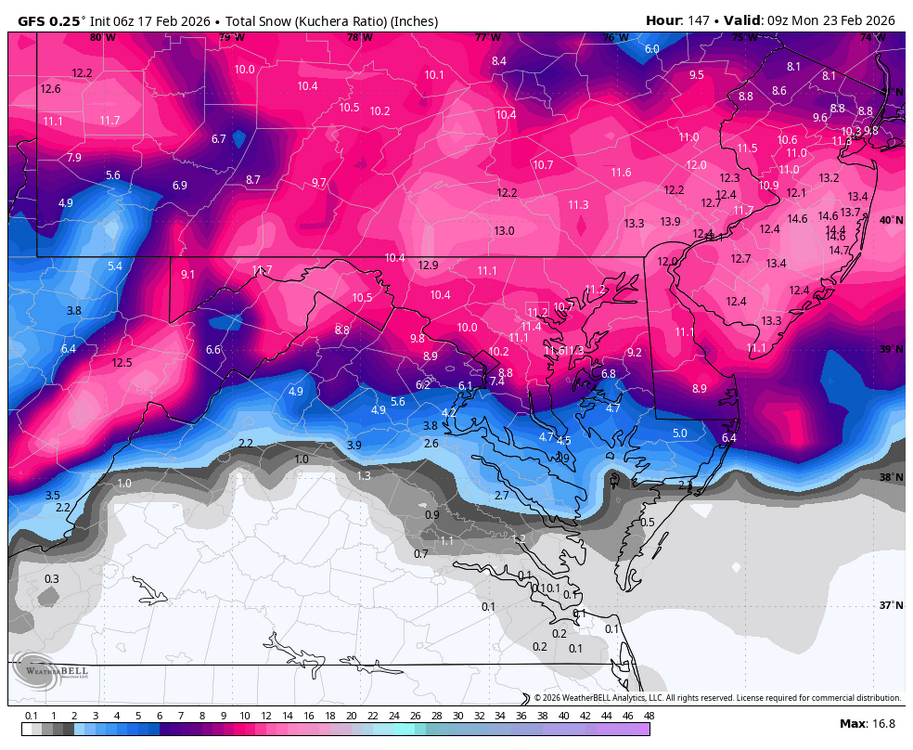
GFS with 8-12in for many. Once again asking the EURO to show anything this afternoon lol -
gfs ai is a historic blizzard it's that simple
-

“Cory’s in NYC! Let’s HECS!” Feb. 22-24 Disco
CoastalWx replied to TheSnowman's topic in New England
Cancelled -
Meh. Offshore
-

2025-2026 Fall/Winter Mountain Thread
ncjoaquin replied to Buckethead's topic in Southeastern States
GFS shows a pretty impressive NW flow event. Let's see if it holds. -

Late February/Early March 2026 Mid-Long Range
Weather Will replied to WxUSAF's topic in Mid Atlantic
WB 6Z GFS: transfer to coast is far enough south and close enough to the coast this run.
-
6z GFS looking good at hr120
-
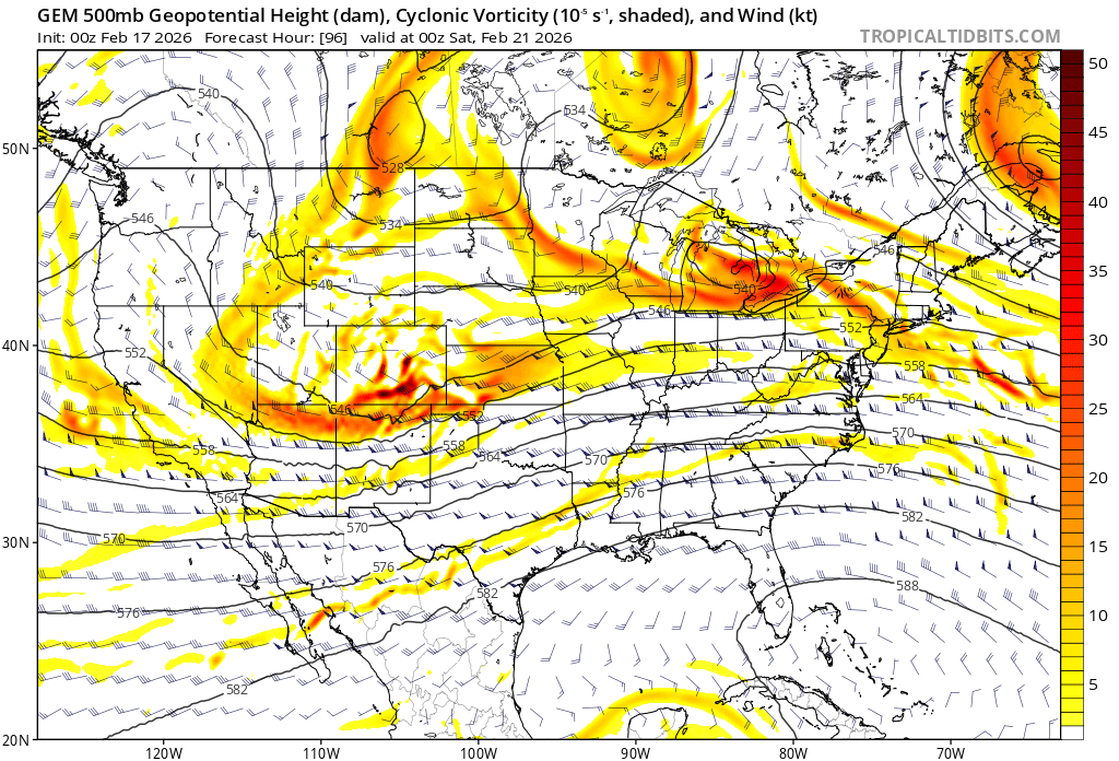
At the risk of pointing out the obvious, we have not one but two systems that need to resolve and play out that will have some impact on the upstream flow. There's at least 3 vortmax cluttered across the playing field immediately ahead of the two that would become the big coastal.

- Today
-
Thank you, as I highlighted your first sentence. Over here our 5 day outlook is rain Friday and Sunday.
-
Thanks for thinking of me. But been screwed last time you all saw the digital snow. Turned out to be rain. I said earlier wait till Friday and I would believe it otherwise it's a nice rain event.
-
6z ICON looked better at hr120.. no idea how it would have ended up though
-
EPS has a decent signal though but I want ai on board
-
Talk to me when euro ai is interested
-

Wednesday Feb 18 Mixed event. NoP refresher?
dendrite replied to HoarfrostHubb's topic in New England
NAM is a tick north and warmer again. But I’m out of the game either way now…onto Friday here. -
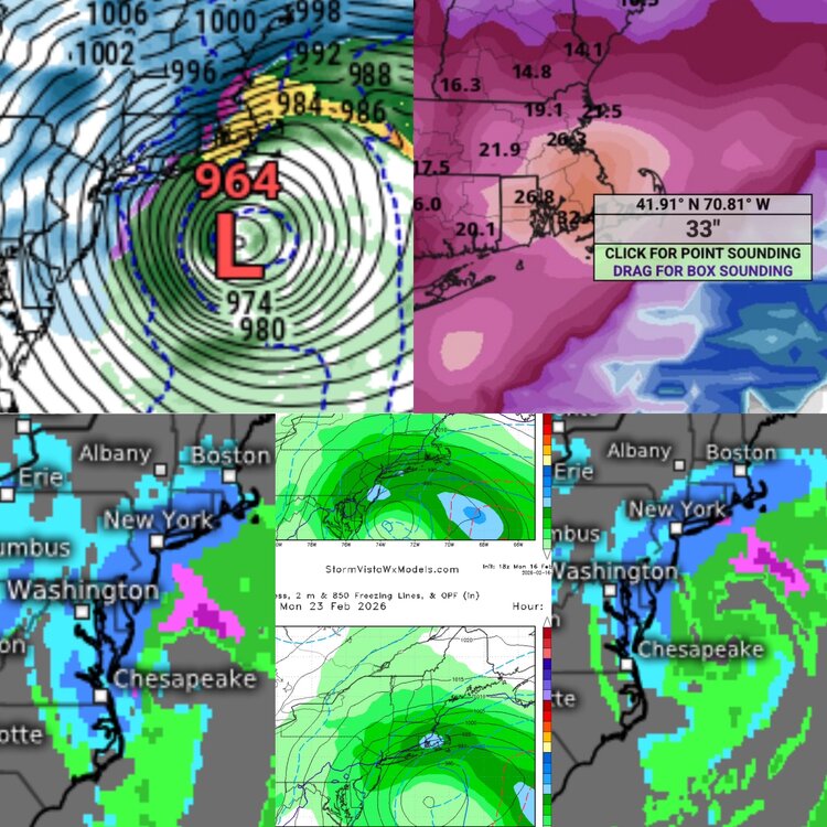
Well, Let’s try This Again since it worked SO WELL LAST TIME! (even though you guys freaked out about me starting a thread) Yes, Once Again I’m off on a trip for gigs, this time in NYC, leaving Saturday, and coming back Tuesday. And you know what happens when TheSnowman goes away while Losing his mind for a storm? The Models Continue to show a Monster Possible Right in the muster of that time frame, with the possibility of a Sub-970mb Low And 24”-36”. The GFS, GEM, and UKIE are All on board as I type this. The EURO has a strangled storm currently OTS; is it Still the dreaded Dr. NO? Let’s track A Potentially TRUE, Historic, Snowstorm and Blizzard. Unlike that overrated SWFE you guys just had.
- 1 reply
-
- 1
-