All Activity
- Past hour
-
Notice how the people now agitating the thread with anti-hurricane center posts are the same ones who were absent till landfall. They’re not worth the time to debunk.
-
But it does... Since the NHC puts out the advisories the media outlets run with them... This what the general public is expecting... and when it doesn't happen... it gives the general public a false sense of security with the next storm.
-
Catskills should do well.
-
Strong forecast. https://forecastmaven.com/forecasts/easternmassweather/hurricane-isaias-landfall-accurately-forecast/ Hurricane Isaias Landfall Accurately Forecast Timing Slightly too Slow The center of the rapidly degrading eye of Hurricane Isaias crossed the coast near Destin, FL with 105MPH maximum sustained winds at about 930PM EDT. This was precisely as forecast in the Final Call issued this afternoon in terms of landfall locale and intensity, but the timing was about 1.5 hours faster than 11PM EDT forecast. Although the landfall intensity needed to be adjusted upwards slightly in the Final Call issued earlier today, the Destin, FL locale was consistent since First Call on Wednesday. Final Grade: A
-
-
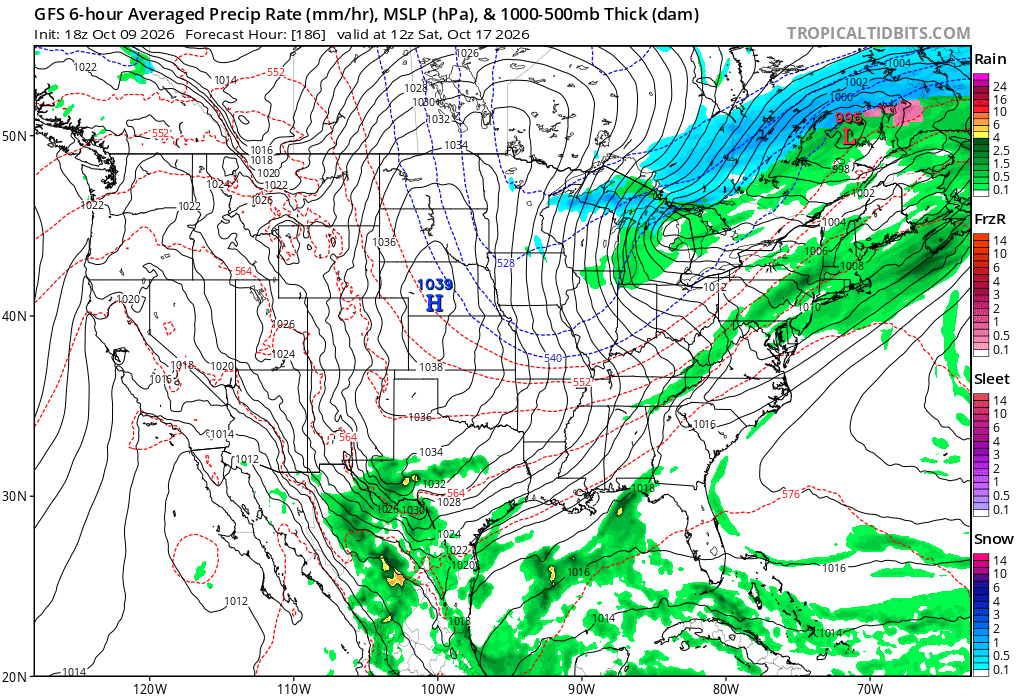
Check out Rogers Pass in Montana at 6700 feet. They might pile up about 33 inches of snow! https://forecast.weather.gov/MapClick.php?x=99&y=149&site=tfx&zmx=&zmy=&map_x=98&map_y=149
-
Hurricane Isaias Discussion Number 14 NWS National Hurricane Center Miami FL AL092026 1000 PM CDT Fri Oct 09 2026 Isaias made landfall as a 90-kt hurricane at 0130 UTC near Destin, Florida. Since that time, the radar structure of the storm has continued to degrade as strong vertical wind shear disrupts the circulation. However, Eglin AFB (KEVX) radar data and surface observations indicate damaging, gusty winds are persisting in the residual northern eyewall and in a band wrapping around the western side of the circulation. Now that the system is farther inland and losing organization, the initial intensity is lowered to 80 kt for this advisory. Isaias is rapidly losing tropical characteristics, and it is forecast to become post-tropical within the next 12 h while it continues moving quickly northward through Alabama. Although the sustained surface winds associated with Isaias will quickly weaken now that the storm is inland, damaging wind gusts associated with the system are expected to extend well inland through Saturday, especially in areas of higher terrain. Because of this, the gust factors in the forecast have been slightly increased during the first 24 h. A turn toward the northeast is forecast later this weekend, bringing the center of the system into the Tennessee Valley before it dissipates. Key Messages: 1. A life-threatening storm surge is expected from Dauphin Island, Alabama, to Suwannee, Florida where a Storm Surge Warning remains in effect. Residents in the warning area should continue to follow advice given by local officials. 2. Extremely dangerous and damaging hurricane-force winds, especially in gusts, are expected over portions of the Florida Panhandle and southern Alabama where a Hurricane Warning remains in effect. Residents in these areas should have a safe room to ride out the storm and prepare for long-duration power outages. 3. Damaging wind gusts are likely over a large portion of the southeastern United States from western and northern Georgia and the southern Appalachians, westward over much of central and northern Alabama, southern middle Tennessee, and Mississippi, especially in areas of higher terrain. Residents should secure loose outdoor items, avoid driving high-profile vehicles, prepare for power outages, and be aware of the potential for falling trees. 4. Isaias will bring areas of heavy rainfall to the central U.S. Gulf coast and much of the Southeast through the weekend. Considerable flash and urban flooding, along with significant river flooding, will be possible. Landslides are also possible across the Southern Appalachians. 5. The tornado potential will continue through tonight. The greatest risk will be east of the center, particularly across the Florida Panhandle into southern Georgia. This risk will continue spreading north-northeast across parts of the Southeast on Saturday. FORECAST POSITIONS AND MAX WINDS INIT 10/0300Z 30.8N 86.5W 80 KT 90 MPH 12H 10/1200Z 32.7N 86.7W 50 KT 60 MPH...POST-TROP/INLAND 24H 11/0000Z 34.7N 86.7W 30 KT 35 MPH...POST-TROP/INLAND 36H 11/1200Z 36.9N 84.4W 30 KT 35 MPH...POST-TROP/INLAND 48H 12/0000Z 39.0N 80.5W 25 KT 30 MPH...POST-TROP/INLAND 60H 12/1200Z...DISSIPATED $$ Forecaster Reinhart
-
It snowed Christmas Eve, around here.
-
 max dose semaglutide [url=https://semaoraldirect.shop/#]SemaOral Direct[/url] rybelsus vs ozempic side effects
 -
This storm is moving pretty quickly - That may well be the saving grace for many areas with respect to rainfall tallies. The rain is already out of the coastal areas; this storm is now all about the inland regions. It's really truckin'! I think at 18 mph!
-
shop medicine online: quetiapine - п»їinternational drug mart
-
What was expected ended up happening just a few hours late, which NHC mentioned as a risk for more intense landfall. My guess is a low end Cat 2 verified in the end. We’ll see in the AM how the damage looks. The surge I’m sure was severe but may have missed Destin just to the east so maybe a slight “win” there.
-

October 2026 General Discussion
MazooWeather replied to SchaumburgStormer's topic in Lakes/Ohio Valley
I wanna believe in these early flakes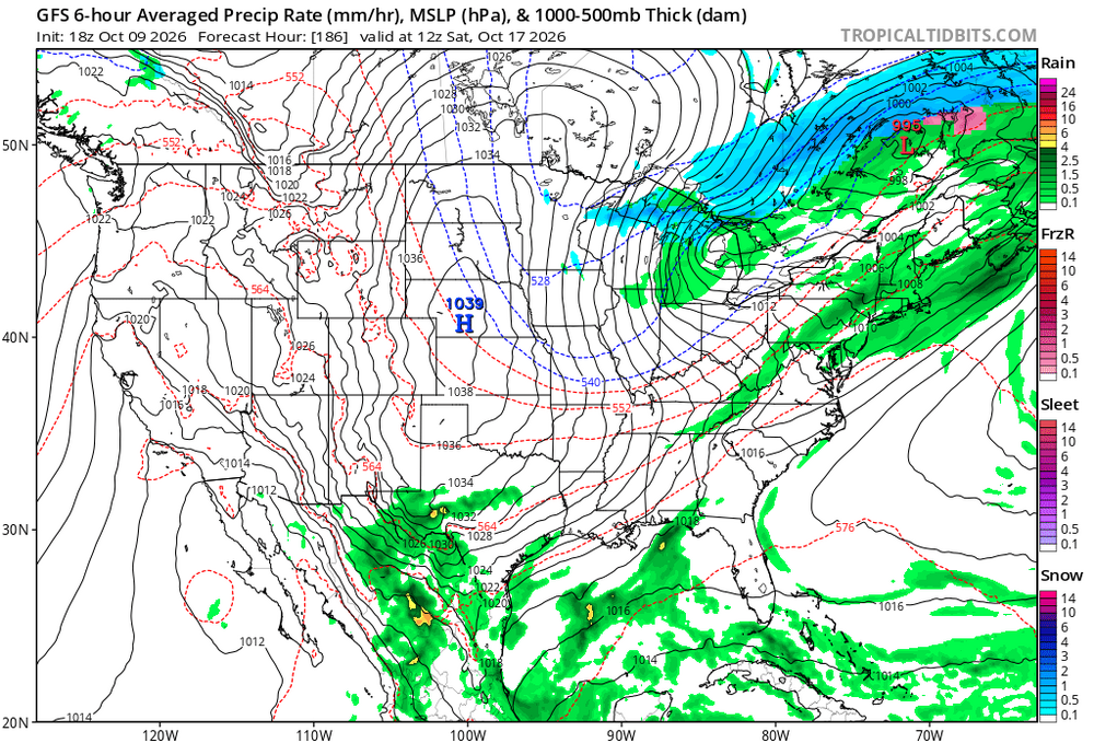
-
https://hydropressdirect.shop/# online pharmacy no prescription needed
-
If you squint, maybe some sting jet type processes going on?
-
Sandy did not become a Nor'easter - it became extra-tropical but it plowed west-ward into NJ.
-
lol trying to compare Sandy with 2020 Isaias. Come on folks.
-
I wonder if I hit my max surge mark of 10'? Killed it on LF locale and intensity. ...should be a quick post-mortem.
- Today
-
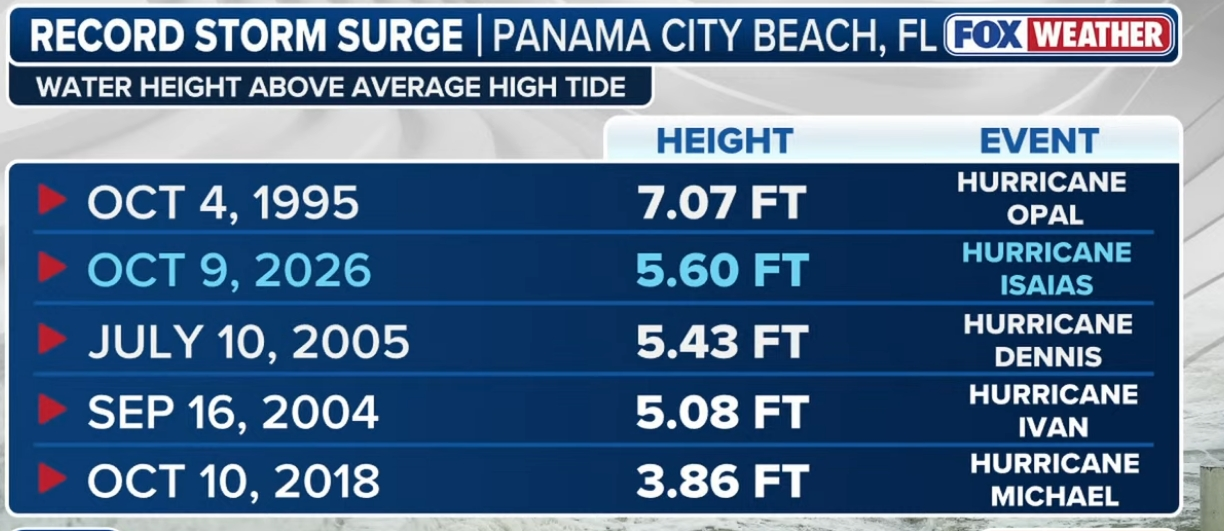
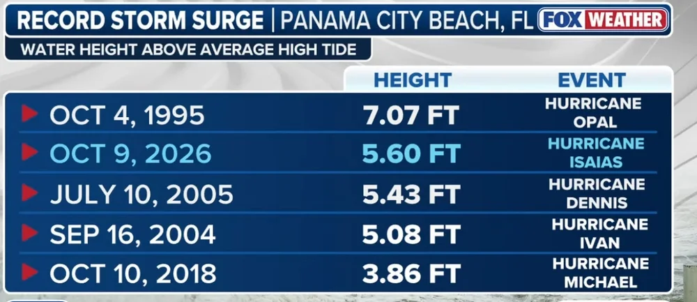
Curious about surge heights between Miramar and PCB. There has been no reports from those locations and I imagine that is where surge peaked.
-
-
By definition the “maximum sustained wind” is going to occur over a very small area and is always going to be over water. This table literally proves nothing.
-
Those winds near PNS are from the second wind max there. Really interesting feature.
-
Ngl it was pretty clear off live feeds alone at the very least that Ian, Ida, and Michael in addition to Laura had higher sustained speeds than what reports said.
-
same city that got like 12 inches of snow two winters ago
-
Milton Florida just recorded 75 MPH sustained gusting to 105 MPH