All Activity
- Past hour
-

Central PA Winter 25/26 Discussion and Obs
Jns2183 replied to MAG5035's topic in Upstate New York/Pennsylvania
I want something that is the equivalent of launching an m80 into a giant African killer bee nest. It would be good for the profession. Sent from my SM-S731U using Tapatalk -

Feb 22nd/23rd "There's no way..." Storm Thread
Terpeast replied to Maestrobjwa's topic in Mid Atlantic
Just reviewed the overnight runs, looks like mostly a hold, or at least similar to 12z yesterday. 18z was the high bar. Hoping to see more of a consensus today... -
Central PA Winter 25/26 Discussion and Obs
Jns2183 replied to MAG5035's topic in Upstate New York/Pennsylvania
God do we need it. March, April, May average 11" and we need a good 21". The top ever for those 3 months was 20.79" in 2011. I'd kill for a good 60"+ year again. Praying we finally get a big tropical system up here for first time in a while. Sent from my SM-S731U using Tapatalk
-
.thumb.jpg.6a4895b2a43f87359e4e7d04a6fa0d14.jpg)
Central PA Winter 25/26 Discussion and Obs
Yardstickgozinya replied to MAG5035's topic in Upstate New York/Pennsylvania
I love seeing the volatility in the atmosphere in Pa. the last two nights. Makes me more hopeful maybe we can bust big . -
Temp dropped to 25F here, a little cooler than expected.
-
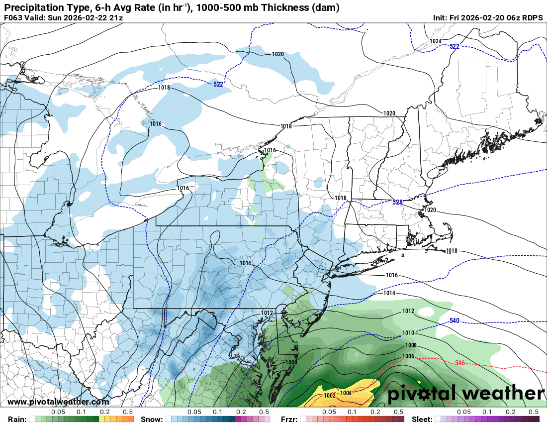
Nam is alone with that much down there. Rgem and icon have precip much further north.
-

“Cory’s in NYC! Let’s HECS!” Feb. 22-24 Disco
The 4 Seasons replied to TheSnowman's topic in New England
I wouldn't take anything the nam is throwing out at 48 hours even remotely seriously let alone 84. It's pretty similar to 00Z however. On the other hand 6z rgem is nice throws a lot of qpf back west. Looks a tick NW from 00Z just glancing at it -
.thumb.png.7358b30d5d2e30c41d1a127587a35490.png)
-
Central PA Winter 25/26 Discussion and Obs
Yardstickgozinya replied to MAG5035's topic in Upstate New York/Pennsylvania
Heavy rain here flash of lightning. -
Central PA Winter 25/26 Discussion and Obs
Yardstickgozinya replied to MAG5035's topic in Upstate New York/Pennsylvania
I could have the wrong person here, but I believe it was @anotherman that brought up the Megalopolitan Blizzard of 1983 last week. I'm certainly not saying that it will, but given what the gfs has shown at times and the slightly cooler column ,I feel that this one has more of a legitimate chance, then last week, to bust towards something like that. I could definitely live with that . -

Central PA Winter 25/26 Discussion and Obs
TheDreamTraveler replied to MAG5035's topic in Upstate New York/Pennsylvania
Absolutely pouring out right now. Haven't seen a big blob of heavy rain like that in a while -

Feb 22nd/23rd "There's no way..." Storm Thread
AmericanWxFreak replied to Maestrobjwa's topic in Mid Atlantic
There are quite a few NAM like solutions in the GEFS members . -

Feb 22nd/23rd "There's no way..." Storm Thread
Weather Will replied to Maestrobjwa's topic in Mid Atlantic
WB 6Z ICON also ticked west.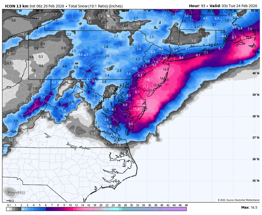
-

Feb 22nd/23rd "There's no way..." Storm Thread
Solution Man replied to Maestrobjwa's topic in Mid Atlantic
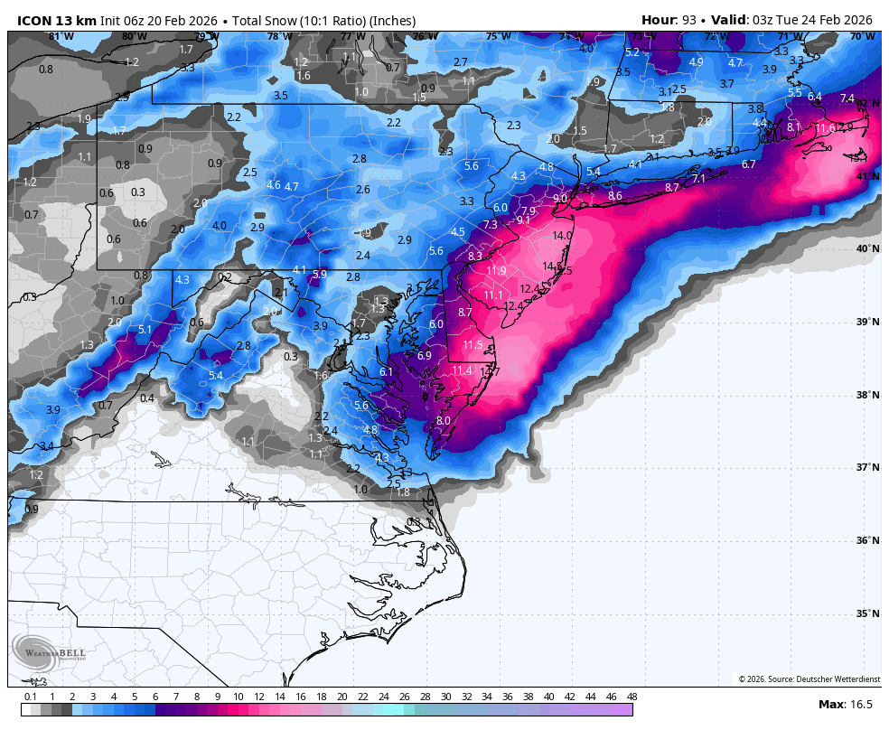
NWS snippet A high energy but low predictability pattern looms for the back half of the weekend. The pattern is forecast to be very amplified, but in flux as a deep upper-level low digs out of the Gulf of Alaska inducing a downstream ridge-building event over the western U.S. This pattern amplification in the vicinity of western North America comes with low predictability due to data sparse regions over the North Pacific. Meanwhile, a pair of downstream upper lows interact/merge over Maritime Canada, with inherent low predictability with two cutoff lows interacting. If the upstream ridge-building event takes place a bit further west near 120 W longitude on Saturday, downstream trough amplification would be favorable for phasing over the mid MS Valley into the OH/TN Valleys Saturday night. A subsequent low track hugging the coast would become more likely in this scenario, aided by downstream blocking and a potential source of cold air given the upper lows over Maritime Canada and surface high pressure attempting to ridge into northern New England. There is also an appearance of an inverted trough signature in a subset of model guidance over the last couple cycles, given interaction between a more amplified northern stream wave and a bit more distant offshore southern stream low. This could factor into precipitation amounts and placement. After reviewing the 00z model guidance suite, some subtle consistency has been noted although subtle uncertainty remains. Most of the models has a low tracking up from GA/AL toward the NC coast and off the Delmarva coast during the late Saturday night into late Sunday timeframe. The question remains in the proximity toward the coast along with cold air availability, and the overall scope of the precip shield pending the placement/intensity of the system. 25 to 50 miles could make a huge difference between seeing little to no wintry precip or impactful precip, especially for those east of the mountains where the confidence remains low due to thermal issues especially below elevations of 1500 feet. The 00z GFS/GEFS solutions have come down a tad, but still produce measurements on the order of 10+" of snow over a large chunk of the area. Meanwhile, the 12z EPS ensembles came up some, but at much more conservative levels which align with deterministic runs of the NAM, RDPS, GDPS, GEM, CMC, EURO/EURO AIFS, and UKMET. The latest NBM also came up a bit and aligns with the majority compared to the GFS/GEFS outliers, especially along and east of I-95. With that said, the 6/12z model suites should put the remaining puzzle pieces together as we will sit 60 hours from the event. Three scenarios remain: 1) The phase of all of these upper level features occurs too late, with low development offshore and too far southeast. 2) Similar to scenario 1, but an inverted trough on the back side of the low brings snow to eastern portions of the region. 3) Low develops closer to shore and strengthens along Delmarva Peninsula, resulting in the most snow for our areas. We still remain in the "wait and see" period with this storm, so just take precautions now, should the worst case scenario play out. Having a preparedness kit stocked up is never a bad idea. -
Feb 22nd/23rd "There's no way..." Storm Thread
Weather Will replied to Maestrobjwa's topic in Mid Atlantic
WB 6Z 12K NAM and not done on the shore.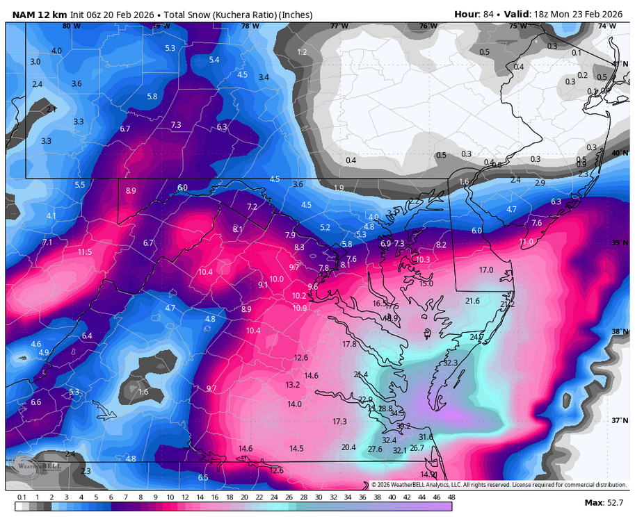
-
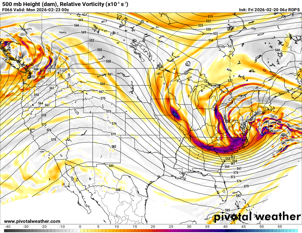
Wow 977 low
.thumb.png.0f43cd396374f58589023f953d3920bb.png)
-
Rgem is nice
.thumb.png.d56b1590c7644b4344d881e590ae9660.png)
-
Central PA Winter 25/26 Discussion and Obs
Jns2183 replied to MAG5035's topic in Upstate New York/Pennsylvania
I'm almost at a point with just how arrogant some local and national meteorologist have become combined with endless whining about models where Im praying for a once in a generation bust either way, just so it pushes out some of these people due to ridicule, installs some humility, and forces people to use model runs like a tool instead of like heroin. Sent from my SM-S731U using Tapatalk -
Rgem looks good
-
Rgem coming in further west and north. Rains in SNJ.

-
Why would Virginia Beach be cold enough for this to be all snow? Hopefully just the long range NAM F'n with us.
-
Icon NW
.thumb.png.27e11f7f2cc86df463e96a97b70b5dc8.png)
-
Feb 22nd/23rd "There's no way..." Storm Thread
Solution Man replied to Maestrobjwa's topic in Mid Atlantic
Nam at range precip field quite a bit wester on this run. Looks like it’s in GFS camp…gives Norfolk 30 inches lol -

Central PA Winter 25/26 Discussion and Obs
Voyager replied to MAG5035's topic in Upstate New York/Pennsylvania
Probably not a bad idea... I've got to say, I've always been a go big or go home snow person. This time even moreso. We're down to barely a 2" snowpack, and the rain we had Wednesday afternoon/evening washed most of the salt residue off the roads. At this point, if we can't get 8-12+, then I'd prefer the NAM's no snow showing. -
Central PA Winter 25/26 Discussion and Obs
Yardstickgozinya replied to MAG5035's topic in Upstate New York/Pennsylvania
There hasn't been any lightning strikes detected for quite a while, but it looks like a lot of the sub is getting some decent rain atm.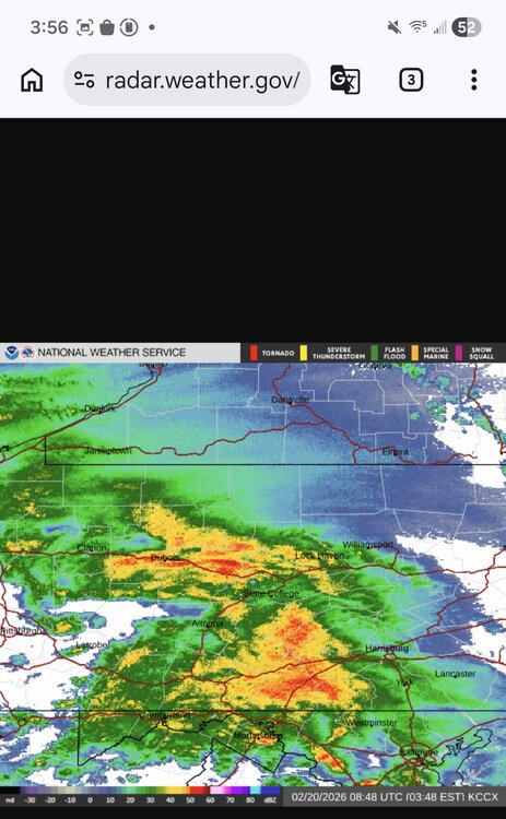


.png.60a2a6da3e2ea22729e66dd7fcc80d1c.png)


.png.7bd1dff65d52e628ab702d508f5312c2.png)
.png.61f2b9396f9c3c0413234bc33fd1e4c5.png)


.png.dbc9020c191148970eb50033af59a3e7.png)
