Search the Community
Showing results for tags 'Tornado'.
Found 13 results
-

March 2nd Moderate Risk ArkLaTex
Ed, snow and hurricane fan posted a topic in Central/Western States
After today's significant Oklahoma outbreak (a derecho and SigTors), March 2nd already 30%. Thursday afternoon and evening look severe-ish. -
I’ve seen discussion in multiple threads, so here’s one for the storm. Should be a good widespread rain across a lot of the area. Tropical storm wind gusts working up the coast. Should be some gusty winds with whatever remains of the core as it moves through the Carolinas and into Virginia. Tomorrow afternoon could feature a tornado threat from the SC low country in NC coastal plain
- 28 replies
-
- 2
-

-
- elsa
- tropical storm
- (and 3 more)
-
From the album: Summer 2016 Thunderstorms
A tornado-producing thunderstorm takes on a purple tint as the sun begins to set near Warwick, North Dakota. August 3rd, 2016. -

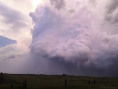
From the album: Summer 2016 Thunderstorms
A thunderstorm just southwest of Warwick, North Dakota produced a tornado on August 3rd, 2016. This photograph captures the early stages of the tornado. -
The United States has a greater frequency of tornadoes than most other counties. For many factors, the vast majority of tornadoes occur east of the Rocky Mountains across the continental U.S. Although the central and southern Plains region is widely considered to be "Tornado Alley," there are other areas that see just as many tornadoes, if not even more. The two graphics below are adaptations of NOAA/NWS SPC graphics found in their Tornado Environmental Browser. A broad area from the east slopes of the Rockies east to the west slopes of the Appalachians typically see the most days with tornadoes per year. Two local maximums can be identified in northeastern Colorado and central Florida. While these areas may see numerous tornadoes in any given year, they are generally low on the EF-scale. The central Appalachians feature a local minimum of tornadoes, but as one travels east, the frequency of tornadoes increases. While terrain by itself will generally not have much of an effect on a tornado, especially a significant (EF/F-2 or stronger) one, there are reasons why terrain affects tornado frequency. In the Plains, lee cyclogenesis combined with a surge of warm, moist air from the Gulf of Mexico and drier air from the Rockies tends to create a favorable setup for severe thunderstorms and tornado development. Across the East Coast, there is less real estate to work with when considering the proximity to the Atlantic Ocean. Also, wind out of the south to southeast in the lower levels will often mitigate the risk of severe thunderstorms, especially in the spring and early summer months from the mid-Atlantic region into the Northeast. The placement of a "Bermuda" high and/or a "southeast ridge" of high pressure will tend to limit the formation of strong non-tropical low pressure systems along the East Coast during the warmer months, as the jet stream is often displaced further northwest. The frequency of days with significant tornadoes is in some ways similar to, but also has differences in comparison with the frequency of days with all tornadoes. While portions of Colorado and Florida may see the most tornadoes overall, there are two distinct areas that feature a much greater frequency of significant tornadoes. The southern Plains into Dixie Alley (lower to mid-Mississippi Valley) will on average experience the most significant tornado outbreaks. Here, there are three factors that are probably most responsible for this. First, their proximity to warm, moist air from the Gulf of Mexico fill favor higher dew-points and greater instability. Second, the tornado season is a bit elongated here. While April into May have featured the most significant tornadoes in Dixie Alley, the late fall into winter months have also included several major tornado outbreaks. Finally, there may be at least some influence from tropical systems. While tropical storms and hurricanes often do produce tornadoes, it should be noted that most of these tornadoes are generally not significant. Eastern Nebraska into the Midwest also averages an elevated number of days per year with significant tornadoes. Here, while the tornado season typically peaks in June, at least some fall tornado events have spawned significant tornadoes this far north. In 2013, October 3rd-4th recorded six significant tornadoes from eastern Nebraska into Iowa, with the major tornado outbreak of November 17th featuring 32 significant tornadoes in the Midwest. Other noteworthy observations: Missouri is an interesting case. The western portion of the state is often considered to be in tornado alley and some maps will place southeastern Missouri in Dixie Alley. The state has seen plenty of significant and even violent tornadoes, with the Joplin tornado of 2011 being one of the more recent examples. However, a small section of central Missouri features a local minimum in terms of both tornadoes and significant tornadoes. One possible explanation can be their location being in a "dryslot" of sorts for tornadoes. For storm systems developing just east of the Rockies, the eastward extent of associated severe weather will often fall short of central Missouri. Likewise, systems developing in the lower Mississippi Valley often form a bit too far east to target central Missouri with the most tornadoes. West Virginia has less tornadoes than most states east of the Rockies. One factor that immediately comes to mind would be the population density and terrain, which may limit some tornado reports. However, their location along the Appalachians certainly plays a role in the lower frequency of tornadoes. The higher elevations will typically have less instability. Likewise, moisture pooling will typically favor higher dew-points west and east of the Appalachians, leaving West Virginia in another tornado dryslot. According to the NWS, West Virginia has no recorded EF/F-4 or 5 tornadoes. With that said, a long-track F-5 tornado in southeastern Ohio narrowly missed passing into West Virginia before lifting. Also, an F-4 tornado that dropped southeast of Pennslvania into Maryland also lifted shortly before it would have passed into West Virginia.
-
Here's a recap of the 2013 tornado season across the Northeast. Connecticut had four reports of tornadoes during 2013, which is roughly twice the average amount of about two. Keep in mind that 2012 had no tornadoes in the state, so one could argue that this was nature's way of balancing itself out. Elsewhere, New Jersey was the only other state in the Northeast with above average tornado reports. (They average two per year, but had three in 2013) Maine is not pictured here, but Maine had at least two tornado reports. Since they average two per year, that's right at average. Massachusetts also saw an average year with one tornado report. Vermont and New Hampshire typically average about one tornado per year, but both states saw no tornadoes this year. New York was well below average with just four tornadoes. The average there is 10 per year. Pennsylvania reported nine tornadoes, also well below their average of 16 per year. Averages based off of 1991-2010 reports, per NCDC. April 19th: An EF-1 tornado touched down near Bainbridge, N.Y. and was on the ground for 3.2 miles. (link) May 9th: A weak EF-0 tornado touched down near Stoughton, Mass., but the length of damage was less than 0.5 miles. This was a cold air funnel case and not a "classic" tornado. (link) May 28th: There were four tornado reports across northwestern Pennsylvania. Three of the tornadoes were rated EF-1s and one was an EF-0. The longest tracking tornado was an EF-1 that touched down near Edinboro and had a damage path of 18 miles long. May 29th: Two tornadoes were reported in eastern New York State. One was a significant, long-track tornado (EF-2). It was on the ground for 17 miles and the damage path was up to 1 mile wide. Another tornado, a weaker EF-1, was reported just to the southwest of that storm. (link) June 2nd: Two brief and weak EF-0 tornadoes were reported in Maine. June 27th: Two EF-1 tornadoes were reported in central Pennsylvania. July 1st: A somewhat unusual morning tornado (EF-1) was reported in extreme northeastern New Jersey. The same storm that was responsible for that tornado resulted in three tornado reports across Connecticut from late morning into early afternoon. The first report was an EF-0 that touched down in Greenwich. The most notable tornado was the second one, which was an EF-1 in the Windsor and Windsor Locks areas. A weak, brief EF-0 tornado was the third report in Enfield. (link) July 10th: A brief EF-1 tornado was reported near Moravia, Penn. during the afternoon. Less than an hour later, an intermittent EF-1 tornado was reported in Connecticut between Andover and Mansfield. The damage path of that tornado was 11.2 miles long. July 27th: An EF-1 tornado was reported in north-central Pennsylvania near Borie. That same storm dropped another EF-1 tornado in adjacent New York State about an hour later. The second of those two tornadoes was on the ground for 14 miles. August 7th: A minor EF-0 tornado was reported in southwestern Pennsylvania near Ralphton. August 13th: A weak EF-0 tornado was reported near Manahawkin, N.J. October 7th: An EF-1 tornado was reported near Paramus, N.J. The tornadoes pictured above across Delaware, Maryland and Ohio were not included in the above time-line. As might be expected, the strongest and longest-tracking tornadoes across the Northeast this year were across New York and northwestern Pennsylvania. Those areas are climatologically favored for significant tornadoes, at least when compared to areas further east. With that said, there have certainly been cases of strong tornadoes in southern New England. The most recent case was the deadly EF-3 tornado that tracked across south-central Massachusetts on June 1st of 2011. The above image is a composite that is not perfectly to scale. United States tornado seasons: Through then winter, the Gulf States are favored for tornado development. There was a minor event this past Sunday, on January 12th, that featured a few EF-0 tornado reports in extreme southeastern Virginia. Into spring, the focus shifts toward the Midwest and late spring into early summer is when the Northeast most commonly sees tornadoes.
-
The National Weather Service (NWS) reported that an EF-0 tornado touched down in eastern Massachusetts Thursday afternoon, shortly after 4:30 p.m. An upper level low lifted northward through New England on Thursday. An unseasonably cold air mass was in place, resulting in cold temperatures aloft. It was the combination of low Lifted Condensation Levels (LCL's) and moderate wind shear aloft that helped create an environment that was marginally supportive of tornado development. It is possible that a land-sea interaction with winds off of the nearby ocean may have played a role in spawning this tornado. The NWS reported that it was a case of a cold air funnel. The tornado touched down in Stoughton, M.A. in Norfolk County and stayed on the ground for 0.25 miles. The tornado was a strong EF-0 with maximum sustained winds of 85 MPH. Damage was minimal, but a local car dealership reported seeing the tornado and had some vehicles blown around by the winds. Looking back at historical tornadoes in the Northeastern United States, the helicity values and amounts of instability in place on Thursday were relatively low compared to prior tornadic events. However, it was the low LCL heights and moderate wind shear that did elevate the tornado potential somewhat. On a scale of 0-5, 0 being unfavorable and 5 being highly favorable for tornadoes (based on local climatology), the environment yielded a value of 1.9. A note that a 2.5 value would be equal to the mean of past tornadoes. PUBLIC INFORMATION STATEMENT NATIONAL WEATHER SERVICE TAUNTON MA 158 PM EDT FRI MAY 10 2013 ..TORNADO CONFIRMED IN STOUGHTON IN NORFOLK COUNTY MA LOCATION... STOUGHTON IN NORFOLK COUNTY MA DATE...MAY 9 2013 ESTIMATED TIME...431 PM EDT MAXIMUM EF-SCALE RATING...EF0 ESTIMATED MAXIMUM WIND SPEED...85 MPH MAXIMUM PATH WIDTH...50 YARDS PATH LENGTH...0.25 MILES BEGINNING LAT/LON...42.10N / 71.10W ENDING LAT/LON...42.10N / 71.10W * FATALITIES...0 * INJURIES...0 * THE INFORMATION IN THIS STATEMENT IS PRELIMINARY AND SUBJECT TO CHANGE PENDING FINAL REVIEW OF THE EVENT(S) AND PUBLICATION IN NWS STORM DATA. ..SUMMARY THE NATIONAL WEATHER SERVICE IN TAUNTON MA HAS CONFIRMED A BRIEF TORNADO TOUCHDOWN IN STOUGHTON MA ON MAY 9 2013. THE TORNADO TOUCHED DOWN AT A CAR DEALERSHIP ON ROUTE 138 WHERE IT WAS CAPTURED BY A SECURITY CAMERA AND RECORDED ON CELL PHONE CAMERAS BY SEVERAL OF THE DEALERSHIP EMPLOYEES. THREE RV TRAILERS...WEIGHING ABOUT 5000 POUNDS EACH...WERE PUSHED BACK ABOUT 6 FEET AGAINST A CHAIN LINK FENCE. ONE TRAILER WAS LIFTED ABOUT 15 FEET INTO A LIGHT POLE BUT LANDED ON ITS WHEELS WITH MINIMAL DAMAGE. AN ALUMINUM DOOR ABOUT 20 FEET HIGH AND 15 FEET WIDE WAS BLOWN OUT OF THE SERVICE GARAGE. EYEWITNESSES REPORTED CEILING TILES BEING LIFTED INSIDE THE DEALERSHIP AS THE TORNADO PASSED OVERHEAD. THE TORNADO ENTERED A WOODED AREA JUST TO THE NORTHEAST OF THE DEALERSHIP. ABOUT 0.25 MILES AWAY...TWO LARGE PINE TREES WERE DOWNED ON ERICA DRIVE AND DEAN ROAD BEFORE IT DISSIPATED. BASED UPON A SURVEY OF THE DAMAGE...THE TORNADO IS CLASSIFIED AS EF0 ON THE ENHANCED FUJITA SCALE WITH MAXIMUM WINDS OF 85 MPH. THE PATH LENGTH WAS 0.25 MILES AND THE MAXIMUM WIDTH WAS ABOUT 50 YARDS. Here's a look at radar imagery about a half hour before the time of the tornado: The Supercell Composite Parameter was relatively low, although some slightly higher values did target the area near the tornado touchdown: The only severe weather report in the Northeast on Thursday was that tornado in Massachusetts!
-
Not much has changed. It is starting to look as if the warm sector will continue East in active form. Could see a multi day severe weather outbreak from the Plains to the Ohio Valley/dixie alley. People in KS, OK, MO, and AR really need to be paying attention to this. Original blog post on this: http://www.americanwx.com/bb/index.php/blog/8/entry-95-early-week-plains-severe-threat/
-
Looks to be a significant severe weather threat early next week. An area of low pressure is expected to develop and move off the Rockies … as usual with upper level energy approaching/crossing the Rockies. Ahead of this system, there will be an extended period of northward return flow off the Gulf of Mexico … setting the stage for a moist and unstable boundary layer as our system moves in around Monday. A dry line will develop across Western parts of Kansas, Oklahoma, and Texas. As the dryline moves East, forcing (dryline and upper trough) looks to become sufficient for the development of thunderstorms within moderate to large instability and long/open hodographs. If things hold, would likely be a moderate or high risk day from SPC … with violent/strong long track tornadoes possible across parts of Oklahoma and Kansas.
-

Possible Plains & MS River Severe Weather Episode Next Weekend
thunderman posted a blog entry in thunderman's Blog
Some type of severe weather threat is appearing more likely around the Saturday time fame from KS down into northern TX as a low develops on the flat side of the Rockies and works to setup/organize a dry line and triple point region. As the system pushes east, there is the potential to have a respectable cold front kicking into a moderately to highly sheared 60F+ Td warm sector along the MS River/Dixie Alley. Obviously too early to start boarding the train, but there is def potential for this system to produce a multi-day severe weather event ... possibly an outbreak ... from the Rockies east towards the MS River. Crappy moisture return is the biggest thing that could easily bust the event IMO. -
Evening/Overnight Tornado Threat in MS River Valley Region
thunderman posted a blog entry in thunderman's Blog
Eventual tornado threat will depend on how unified the current line of storms becomes. If it can manage to maintain some semi-discrete updrafts within the line, then all current data points towards a significant nighttime outbreak across AL/northern LA/western MS. The combination of boundary parallel upper SR winds and low level SR winds on the order of 20-40 knts has me personally a little worried about a too unified squall line ATTM for a significant tornado threat. Some guidance manages to keep the southern end a little less unified enough that it overlaps with favorable hodograph environments ... so around the LA/AR border area may end up being ground zero for this event. -
MS Valley Severe Weather Outbreak Potential 1/28/13
thunderman posted a blog entry in thunderman's Blog
Severe weather outbreak looking more and more possible across portions of the lower Mississippi Valley and deep south tomorrow and tomorrow night. This evening the culprit low is located across western Kansas with a warm front stretching along the Kansas border and into northern Missouri. The dryline is located from west of KICT down through western Oklahoma and Texas … roughly along a line from Altus, OK to Sweetwater, Texas and then southwest from there. The cold front is lagging behind in far western Kansas and eastern New Mexico. A fairly large moist warm sector has developed thanks to an extended period of southerly winds off the Gulf. Dew points in the 50s extend almost up to the Missouri/Iowa line ahead of dryline/cold front and will generate instability on the order of around 750j/kg despite clouds and lack of strong radiational heating of the boundary layer. As forcing increase aloft and steeper lapse rates move in, atmosphere will likely pop along/ahead of the dryline as it punches into eastern Texas. Models hinting at two potential dryline bulges north and south of Austin, Texas. This will have to monitored for possible initiation areas as the morning/afternoon progresses. Low level storm relative winds on the order of 20-40 knts and upper/mid level storm relative winds parallel to dry line/initiation axis will promote uniform gust front lifting and upscale growth into a squall line/QLCS structures with damaging winds being the primary threat. Convection will move East with the evening and overnight hours. As it does, shear will increase across Arkansas, Louisiana, Western Tennessee, and Mississippi and hodographs are expected to become open and elongated. Thus, the tornado threat will likely increase as we approach dark and persist into the overnight … especially if more QLCS type structures can be maintained though the time period. Couple this with low LCLs under 500 meters and there could be a strong tornado somewhere tomorrow night … again if semi-discrete QLCS structures persist. Folks across southern Arkansas, northern Louisiana, and western Mississippi definitely need to monitor this situation closely.


