Search the Community
Showing results for tags 'Hail'.
Found 8 results
-
I'm doing it....the 2026 iteration starts today. With potential warm weather on the horizon, we will likely see the start of the pencil thing gusty shower line season. @yoda - I feel like you're usually on board with early tracking with me. Excited to get back to our smaller spring/summer crew...The winter weenies can take their bickering away soon enough. As much as I hate summer heat - I tolerate it for thunderstorms. And now....I will go back to watching CFS/weeklies/CSU-MLP/CIPS pages for signs of our first threats!
- 1,680 replies
-
- 8
-

-
- severe
- thunderstorms
- (and 7 more)
-
It's early, but might as well do the annual severe thread (people were talking about it in the long range thread!). I don't have the @WxWatcher007 scale handy on this computer - but I usually post it for posterity for the upcoming severe season. Anything from discussing past events to potential upcoming patterns/analogs, and discussion about more specific upcoming threats can be posted in here. A while ago we stopped doing event-specific severe threads for most things. Whether we do that or not - this is the general thread. Have at it!
- 1,696 replies
-
- 3
-
-
- severe
- thunderstorms
- (and 5 more)
-
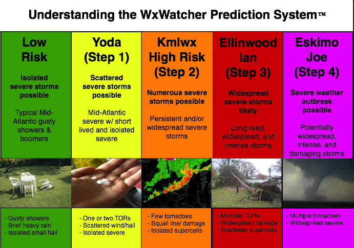
Given that there is a tiny chance at something next week, we'll go ahead and open up the 2023 iteration of the thread. I doubt it will amount to much of anything (perhaps a better chance in the Carolinas and far SEVA) but we'll see. General mid to long range discussion can go in here, as can discussion about past events etc. In past years this has also served as a bit of an "on the fly" obs thread for events that are too small to warrant a separate thread. Pretty casual rules in this annual thread. Looking forward to our usual folks And as always - attached is the @WxWatcher007 tier system for our severe threats here in the Mid-Atlantic subforum.
- 2,785 replies
-
- 9
-
-

-
- severe
- thunderstorms
- (and 3 more)
-
Mid February is usually when the early peeks at severe can sometimes start showing up. Judging by the models and the long range thread, looks like maybe a marginal threat for Thur night? General severe discussion, remembering past events, and all that usual stuff that goes in here each year can go in here again. Hopefully we get some good thunderstorms this spring and summer. Looking forward to plenty of copy and pasting from @yoda, downer posts from @Eskimo Joe, great analysis by @high risk, and plenty of sun obs that turn into nothing. Giddy up! And for humor sake - see below

-
 SPC 854A upgrade -slight expansion D1 attached. ...Northeast... Scattered to locally numerous thunderstorms are expected to develop from late morning through the afternoon along/ahead of the cold front -- first in northern/western portions of the region, then spreading/expanding eastward. Sporadic damaging winds and isolated severe gusts/hail are possible. While magnitude of damaging gusts should be mostly subsevere to marginally severe, given the lack of both greater moisture/buoyancy and low-level flow, the expected dense coverage of convection may result in enough events to justify a 15%/categorical upgrade to wind probabilities at this time. Convection will be supported by a combination of weak MLCINH, diurnal heating, modest but adequate low-level moisture, boundary- layer convergence near the front and low, and large-scale lift aloft ahead of the shortwave trough. Moist advection should increase surface dew points over most of this area to the upper 50s and low 60s F. This will contribute to MLCAPE mainly in the 300-800 J/kg range. Strong mid/upper (anvil-level) winds will aid in organization, though low-level flow will remain too weak to enlarge hodographs appreciably. Well-mixed sub cloud layers will aid in localized strong-severe gust potential, until evening stabilization of the boundary layer removes enough low-level CAPE/lapse rates to weaken convection substantially with proximity to the Mid-Atlantic Coast and western New England.
 -
The evolving pattern this coming week is continuing to model high CAPE (Heat Index NYC metro non-marine influenced near 100F) Tue-Wed and even Thursday afternoons with enough wind aloft and instability to permit one or 2 days of SEVERE storms in our area. Tuesday SVR appears relegated North of I80 (mainly NYS/CT). Wednesday to me looks like a potentially big day, especially I80 region northward with TT in the lower 50s, big CAPE. Thursday into Friday: Uncertainty on evolution but big CAPE and instability probably remain in the vicinity of our subforum. It too could be a severe day, however of interest is the eventual position of the frontal boundary. IF, it drifts down into our subforum with light north-northeast flow north of it, then it seems to me the projected path of decayed ELSA wind fields and moisture plume - convergence (925-850MB southerly flow overrunning a cool frontal boundary, ranging up to the 200MB RRQ of jet located in se Canada) would promote the potential for a Predecessor Rainfall Event (PRE) as documented in research by NYS associated well known mets. Have added a couple of their composites. These 4+" events occur 24-36 hours in advance of the TC, located hundreds of miles north or northeast of the TC even though the TC itself can miss to the south. If it doesn't and tracks over the PRE then that magnifies the potential sub-basin (mesoscale) trouble. As we are aware, we're starting to pile up the water across our subform so this potential result-NOT guaranteed, should be monitored and we'll see if it can occur, fritter, or displace north of our subforum. I'm doubtful if the potential displaces south of us. My guess is we'll know by Tuesday or Wednesday. In the meantime, I think we can expect severe storm wind/hail in parts of our area during midweek, along with possible storm cluster FF in PW air of 1.6", and probably should monitor the evolution of ELSAs ensembled wind fields up this way. Composites are added, as well as 00z/3 EC PWAT for late Thu (showing the TC well south but PWAT axis up near here). This is imperfectly modeled, the speed and location of ELSA and associated wind fields will adjust and affect the results. Let's see how this may breakdown and whether or not we can pick up ISOLATED 4-6" new rainfall between Tue-Fri in parts of our area-ISOLATED. WPC went to press this morning with a general 1"+ for our area, which supports embedded isolated heavier. You probably recall around the 28th-29th they had our entire area 1.5" for the current ongoing event with general 2"+ central and S NJ. Appears they did quite well. 638PM Monday July 5- EDITED Title to include ELSA- Too much modeling is drifting its track within range of coastal NJ and LI for Tropical Storm considerations Thu night-Friday AM. While it's not certain to make a direct second landfall across LI/southeastern New England, think it best to open the door a little more, at the least for 4+" rains this week combined convective outbursts and whatever Elsa.
-
SPC continues Marginal risk se NYS-NJ. 00z-06z/20 HRRR/NAM/EC have decent development Wednesday afternoon. TT near 53 flag attention for hail and gust transfer looks like 40-45KT. Follow NWS local offices/SPC/and our own members assessments. Have added the SPC discussion plus the EC (just below SPC)/GFS (below EC) fcst sounding for 18z/21 n central NJ as an idea of what seems to be coming via convection for NJ. CAPE is marginal and KI OK. Activity while still fairly strong crossing LI/CT will ingest cooler southerly inflow from the ocean to limit potential hailers/wind gusts? Even so, the wind shift with significant cold air advection during the evening may induce isolated gusts 40 kt on the island? Have a look. This thread should also serve well for any significant reports of whatever convection occurs Wednesday afternoon.
-
Hail can be a weather enthusiast delight during the Summer time (perhaps it reminds them of snow?). Unfortunately, forecasting hail size can be a bit of challenge. One method that I use is VIL Of the Day (VOTD). It was developed by the NWS back in the 90s. It purely relies on temperatures aloft and while simple, does a surprisingly good job. Obviously there are some limitations, but I will get to those in a minute. The calculation is straight forward and is as follows: VOTD = 750 / [(h5T+h4T) / 2] where h5T and h4T are the absolute values of the 500mb and 400mb temperatures respectively. The VIL value given from this equation is the approximate value at which you can expect 0.75” diameter hail stones to fall. 0.75” was chosen because this used to be the hail criteria for a severe thunderstorm. For operational purposes, the lower the expected VOTD the higher the large hail potential you can expect. I like to use 40 g/m^2 as a rough baseline in the Summer time. For those that are not familiar with VIL (Vertically Integrated Liquid), it is a radar product that operational meteorologists use to locate areas of heavy precipitation and hail. It is available in real time in all GR-LevelX products and some places on the internet (Weather Underground, etc). See the wiki page for a brief overview. Now back to the limitations of the VOTD approximation. It is best used for regular thunderstorms and not those with established mesocyclones (i.e. supercells) … although honestly it still works fairly well on most supercells we see around here. In storms with well-organized and established mesocyclones, there are additional mesoscale lifting mechanisms at work that can work to produce huge hail more efficiently than what you would tend to find in your average non-supercellular severe thunderstorm. Keep in mind that the VOTD can change as the thermal profile aloft changes. Check forecast soundings (remember, there is more than 1 model) for the afternoon ahead instead of relying solely on the 12z observed soundings. Lastly, VOTD gives you the VIL value for 0.75” hail stones and tells you nothing about maximum hailstone size, etc. I have attached a calculator that I wrote to help me compute VOTD quickly. I wrote it a while back, it’s ugly, it’s written in FORTRAN, but it does the job! votd.zip


