TellicoWx
-
Posts
2,632 -
Joined
-
Last visited
Content Type
Profiles
Blogs
Forums
American Weather
Media Demo
Store
Gallery
Everything posted by TellicoWx
-
Dont know who is over MRX social media page, but this is probably the most honest, direct answer, I think I've ever seen from them. You can kinda tell how stressful working in that office must be due to the microclimates of our region. "Alright good morning everyone from the tired social media leader for this office. Last time I was on shift the models had a large snowstorm draped across the state but my senior forecaster with a few decades of experience had a word of caution "Yeah I've seen these shift north, got to be careful." Now that we're in a completely different situation, I think you're owed a couple of our ice/snow maps. I will preface this to say we're still very much not confident in this. Fairly confident we won't get surprise massive snowstorm, but ice forecasting is not fun and comes down to very exact temperature prediction, how warm/cold the air aloft is, rain rates, and more. The snow is complicated by how much sleet will eat the snow away, and if there's any significant backside snow Sunday night. With all that said, the places that are most likely to see ice, potentially over a 1/4 of an inch are the Cumberland Plateau, the higher elevations of Mowbray and Signal Mountains inching down into Hamilton County, far northern and northeastern TN into VA, and southwest NC, especially Clay County. Finally, if you're in the wind prone foothills, there may be a few gusts over 40 mph Saturday night. Two sides of that coin, not really beneficial to have winds shaking icy trees, but downslope winds tend to warm the air in the lower elevations."
-
I honestly feel for them, counties with I75 from McMinn north are a coin flip on that map (ISW vs WWA).
-
Think they have removed the ice accumulation from your point forecast.
-
Have you read MRX 1am AFD..almost sounds like south of 40 in the valley will be lucky to get a WWA.
-
Same time frame at 12z...the slightly colder south trend allowed a band of 6" snowfall close to the transition line with the heavier precip near Memphis and esstward. Haven't looked at soundings, possible it is an algorithm error. Was just interesting how the slight colder air changed outcome that much.
-
Could just be the crazy uncle doing crazy things...but was just cold enough to put down a 6 inch swath
-
Middle and west TN folks may want to check out the GEM snowfall...just saying
-
Is there a freezing rain map for ICON? Looking at when temps finally get above freezing for valley here, it doubled QPF vs 18z....hard to tell. Definitely a degree or 2 colder that run.
-
^^^ Hrrr is only just starting to get in range for western borders. Outside 18 hrs is about it's limit to me.
-
Probably doesn't mean alot here on east side of the state, but for western folks. 0z hrrr coming in further south in Arkansas with the winter weather.
-
Maybe they forget to switch it from standard to metric? (Just joking)
-
If that's final solution..then they will need the Guard...large power loss, followed by the snow and cold. Governor issued State of Emergency while ago for all Tennessee.
-
Ice storm warning for NW AL out from HUN
-
Its the slowest at arrival of precip. Looking at mby and the microclimate...the GEM has the most realistic temp response for what its worth...with way the temp advances off the Skyway.
-
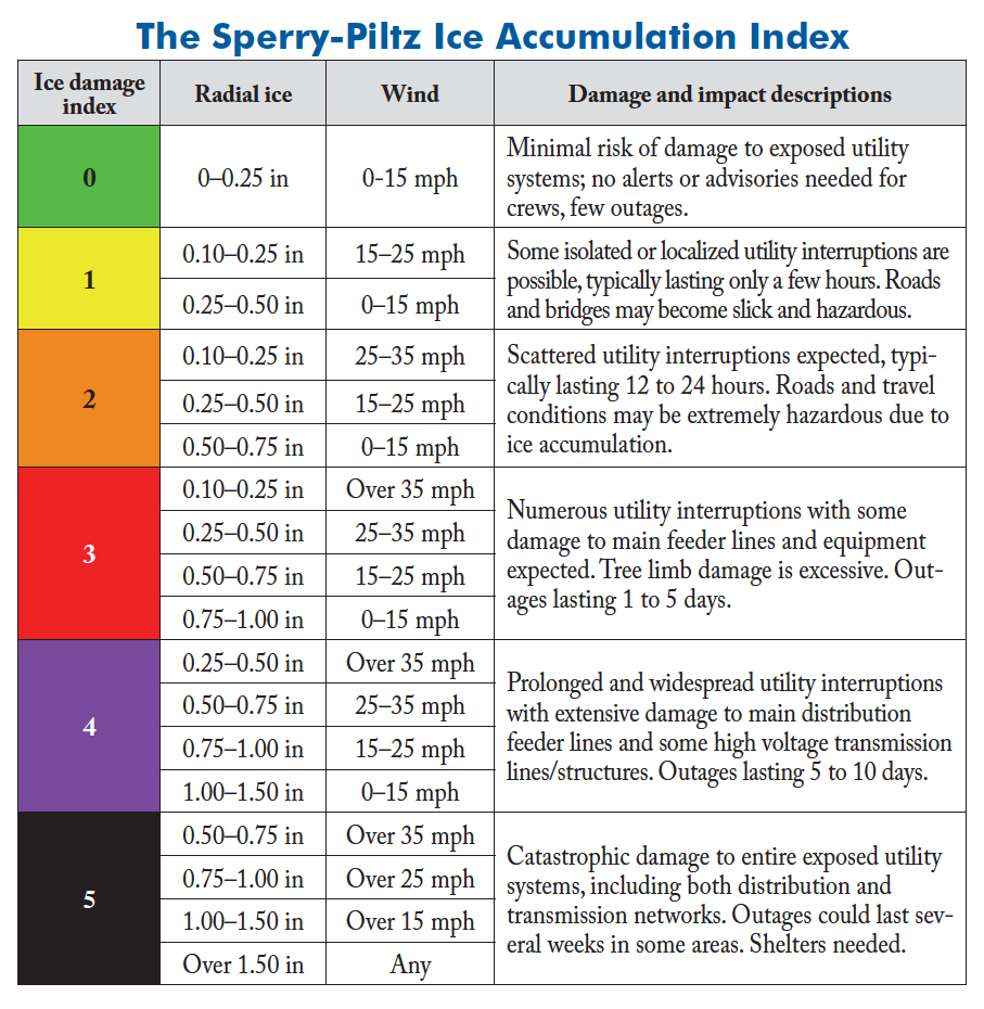
Hopefully no one has to use this chart, but just in case anyone ever needs it. Was designed for risk assessment to power infrastructure

-
The 850 LP is what's wrecking thermals the most..surface LP is only a smaller pct of problem
-
Where's the 850 LP located? Sorry at work
-
Euro and NAM completely lost the ice solution up until 12-24 hrs out. Seems like GFS and RGEM wouldn't budge but got wrote off.
-
This is reminding somewhat of the mid 2010s (cant remember exact year) where foothills of Monroe Co were spared but Madisonville/Sweetwater are were out of power for a week
-
Even on the warmest model..the damage is already done in the lowest valley locations before the switchover.
-
Should have stuck to the old rule of thumb. Find the 850 LP and skip until a system shows where you are on the NW quadrant
-
And that was only a half sarcastic joke about BAM
-
A little more amping and OH isn't going to have to worry about snow on the Euro
-
Mid 60's getting close to Huntsville
-
Euro telling ukie to hold it's beer lmao