NorthArlington101
-
Posts
12,466 -
Joined
-
Last visited
Content Type
Profiles
Blogs
Forums
American Weather
Media Demo
Store
Gallery
Everything posted by NorthArlington101
-

January 2026 Medium/Long Range Discussion
NorthArlington101 replied to snowfan's topic in Mid Atlantic
Snow starts at 120btw. 5 days. -
January 2026 Medium/Long Range Discussion
NorthArlington101 replied to snowfan's topic in Mid Atlantic
Considering it didn’t really have a storm last run, this is an acceptable amount of progress. Would be a pretty annoying final outcome, though (not for our Eastern Shore folks though)
-
January 2026 Medium/Long Range Discussion
NorthArlington101 replied to snowfan's topic in Mid Atlantic
I think it’s gonna go a little late for us. But much better and closer. -
January 2026 Medium/Long Range Discussion
NorthArlington101 replied to snowfan's topic in Mid Atlantic
Unsurprisingly, some big hits in the GEFS. 6/30 pretty good. 1/30 meh. Rest say no thanks for us at least - some OBX winners. But big jump from previous runs.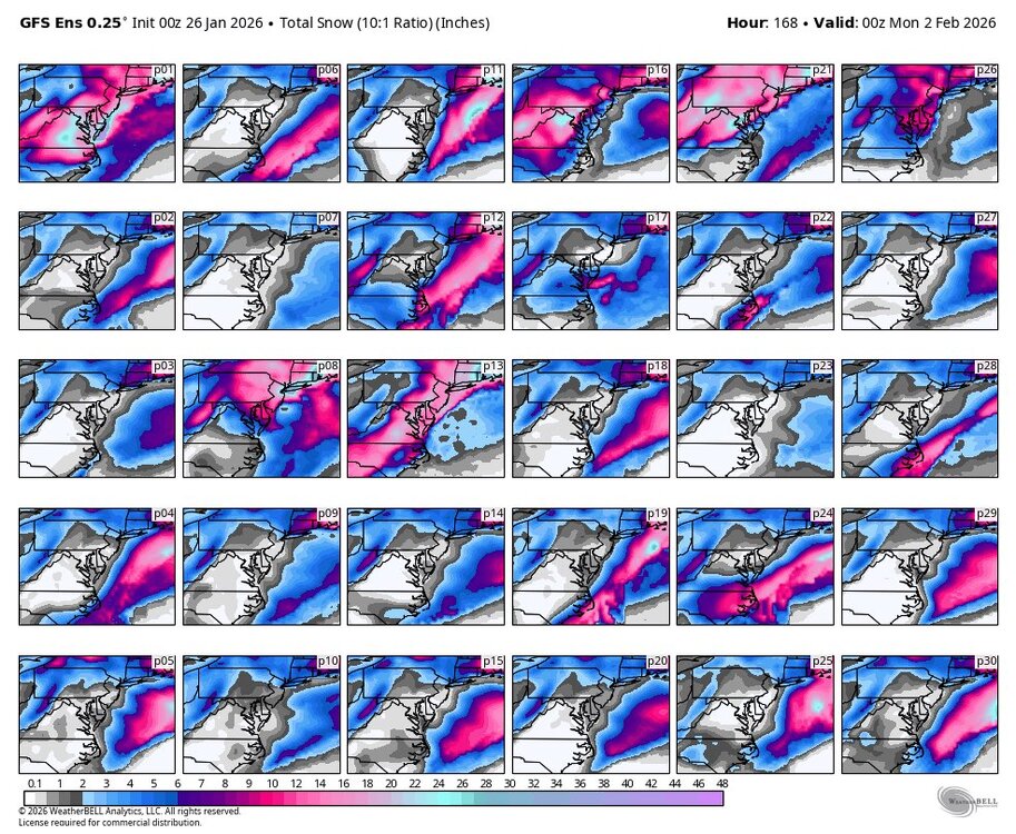
-
January 2026 Medium/Long Range Discussion
NorthArlington101 replied to snowfan's topic in Mid Atlantic
ICON got closer but is wayyy too positively tilted for now. But closer. -
January 24-26: Miracle or Mirage OBS Thread!
NorthArlington101 replied to Jebman's topic in Mid Atlantic
I was gonna go with 7.5” off vibes but I need to see what the spotters around me do. Initial reports made no sense… one 7.0” in Anacosta at 12:30 and a 7.5” in NW… math not mathing. Took a super quick walk and it’s a glacier. My fairly main DC roads are not awesome. Wonder if we really get back to regular commute on Tuesday. -
January 2026 Medium/Long Range Discussion
NorthArlington101 replied to snowfan's topic in Mid Atlantic
Rumor on the block is this nailed today’s storm. Got any more thoughts on it from a more educated perspective? -
January 2026 Medium/Long Range Discussion
NorthArlington101 replied to snowfan's topic in Mid Atlantic
Verbatim yeah but I’d say it’s a tick or two more interesting than the 12z ENS. -
January 2026 Medium/Long Range Discussion
NorthArlington101 replied to snowfan's topic in Mid Atlantic
Did you see the EURO? Right above? Idk. I’ll take my odds on a EURO/AIFS combo with some random AI stuff thrown in at Day 7. We’ve got a fighting chance -
January 2026 Medium/Long Range Discussion
NorthArlington101 replied to snowfan's topic in Mid Atlantic
Seen a couple AI models like the period, including the Google Weathernext 2, which seems to be doing well recently. I’m still interested. -
January 24-26: Miracle or Mirage OBS Thread!
NorthArlington101 replied to Jebman's topic in Mid Atlantic
Up to 27 degrees in DC vs. 21 degrees at my family’s house in Arlington. Some tight temperature gradients going on today. -
January 24-26: Miracle or Mirage OBS Thread!
NorthArlington101 replied to Jebman's topic in Mid Atlantic
Also a glaze starting to appear in DC. Definitely a sleet/freezing rain mix. Not sure what to think about the next few hours. Definitely haven’t felt compelled to go outside since this morning beyond just observing a sleet pack for a second. -
January 24-26: Miracle or Mirage OBS Thread!
NorthArlington101 replied to Jebman's topic in Mid Atlantic
Pure sleet rip page. Hard to not do the “what if it was snow” but this is cool. No idea how much. -
January 24-26: Miracle or Mirage OBS Thread!
NorthArlington101 replied to Jebman's topic in Mid Atlantic
I probably should’ve cleared my “snowboard” but figured it was gonna be tough to keep track of. Just trying to appreciate what’s falling one way or the other… it’s ripping pellets -
January 2026 Medium/Long Range Discussion
NorthArlington101 replied to snowfan's topic in Mid Atlantic
Modeling consensus is definitely that this misses us off shore. Would rather not wait til 384 so just gonna keep tracking it until it’s off the end. Why not. -
January 24-26: Miracle or Mirage OBS Thread!
NorthArlington101 replied to Jebman's topic in Mid Atlantic
I’m still crossing my fingers and hoping never… but let us know if ya’ll do. Probably means we’re a few hours from a flip. Send the dumping sleet up here too! I want to truly get sandblasted -
January 2026 Medium/Long Range Discussion
NorthArlington101 replied to snowfan's topic in Mid Atlantic
Thank you for calling that out… never would’ve seen it. Miller A factory… all time weenie run. -
January 2026 Medium/Long Range Discussion
NorthArlington101 replied to snowfan's topic in Mid Atlantic

-
January 24-26: Miracle or Mirage JV/Banter Thread!
NorthArlington101 replied to SnowenOutThere's topic in Mid Atlantic
Guess mileage is gonna vary here depending on spot. Most of the globals had me in the 7-9” range for snow and I’m at 5”. NAMs were usually too low but minus a really off run usually 3-4”. -
January 24-26: Miracle or Mirage OBS Thread!
NorthArlington101 replied to Jebman's topic in Mid Atlantic
Only good if OPM gives another day off. -
January 24-26: Miracle or Mirage OBS Thread!
NorthArlington101 replied to Jebman's topic in Mid Atlantic
You still pinging @katabatic ? Realize now that Wisp isn't that far from you... would be quite the difference. -
January 24-26: Miracle or Mirage JV/Banter Thread!
NorthArlington101 replied to SnowenOutThere's topic in Mid Atlantic
You gotta know what to look for. I won't pretend the NAM QPF depiction didn't scare me, but I still assumed it was running at least a bit low. The thermals, on the other hand... I set my alarm for 3am for a reason. Had little doubt pingers would be making it into the Beltway when it said they would. Globals/RGEM overdid it on QPF too, fwiw. I'd still call the NAM a winner. Maybe someone smarter will do a retrospective and the RRFS will have really nailed it, idk -
January 24-26: Miracle or Mirage OBS Thread!
NorthArlington101 replied to Jebman's topic in Mid Atlantic
This is the last time the forum underestimates NAM thermals... until the next marginal event. Seems wrong calling this a "marginal event" when the temperature is in the teens. -
January 2026 Medium/Long Range Discussion
NorthArlington101 replied to snowfan's topic in Mid Atlantic
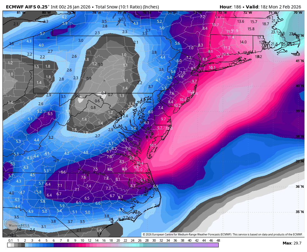
Alright... next. The AIFS and AIGEFS ens are still interesting for next Sunday - moreso the AIFS. Would want to see this come back on an OP run in the next couple of days to make me think we have a real chance. -
January 24-26: Miracle or Mirage JV/Banter Thread!
NorthArlington101 replied to SnowenOutThere's topic in Mid Atlantic
@bnchodid you use your yardstick?