NorthArlington101
-
Posts
12,490 -
Joined
-
Last visited
Content Type
Profiles
Blogs
Forums
American Weather
Media Demo
Store
Gallery
Everything posted by NorthArlington101
-
 It’s total snow out to 264 - 95% of which is from the PD weekend. Median climbed up to 2” as well Problem with the AIFS Ens is they can’t tell mix/cold rain apart from snow sometimes. Don’t know if I trust them.
 -
It’s always a great argument when you bring in your salary! Really tells me you are comfortable in your own expertise.
-
- 553 replies
-
- 10
-

-

-

-
Wouldn’t call it a glacier anymore texture-wise but I would still call it 100% coverage even in Downtown DC
-
The CCB on the backside would be pretty wicked. 1/hr+ rates vs. puddles and mediocre surface temps.
-
-
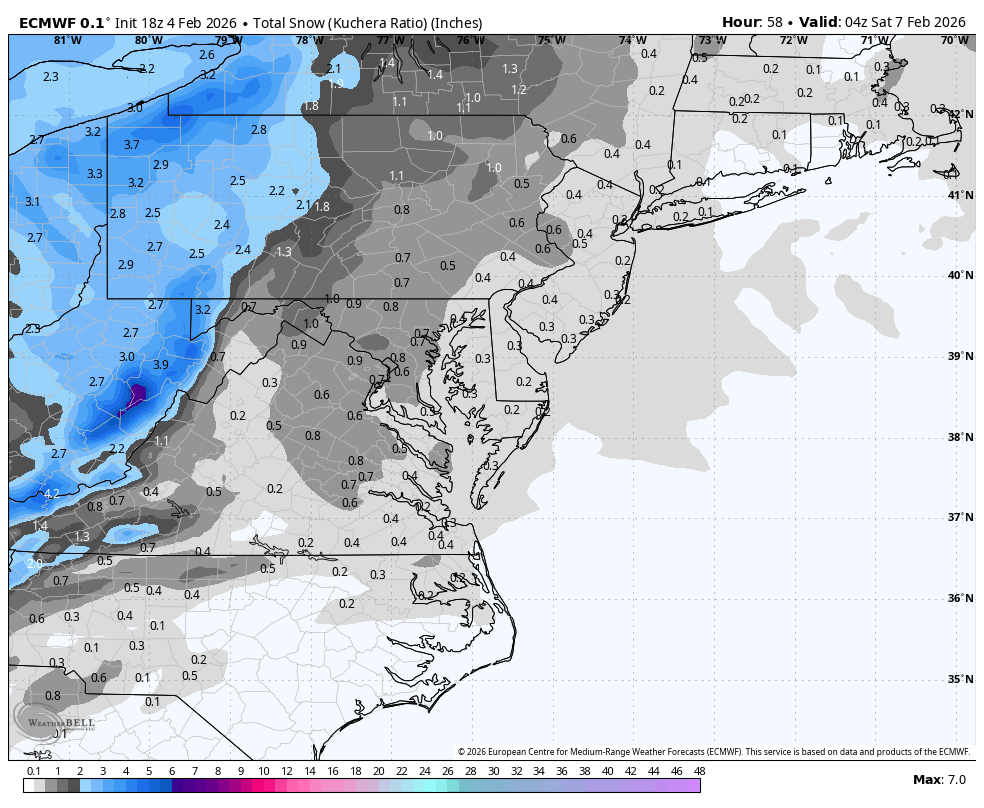
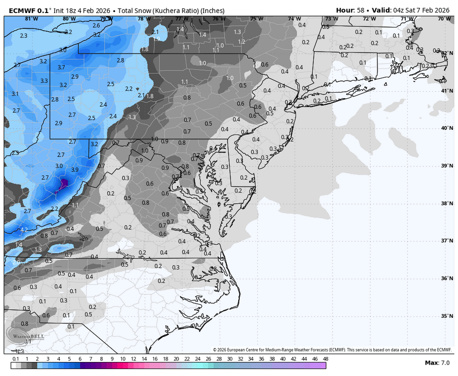
Most of the snow comes from the flip back. Apologies for oversharing maps at 11 days but interesting run
-
Flip back before the storm ends super ninja'd
-
Money panel before everyone flips
-
The Loudoun County wine moms & swim dads appreciate your measured Facebook persona
-
AIFS is suppressed for PD3 but a pretty nice look overall
-
WxUSAF's weak ass frontal passage thing.
NorthArlington101 replied to dailylurker's topic in Mid Atlantic
Maybe 6? It’s really better for severe. Winter definitely isn’t its place, imo. -
WxUSAF's weak ass frontal passage thing.
NorthArlington101 replied to dailylurker's topic in Mid Atlantic
Good win at least! -
WxUSAF's weak ass frontal passage thing.
NorthArlington101 replied to dailylurker's topic in Mid Atlantic
There’s always a northern band! Preparing to get hosed in DC, but that’s fine, I guess. Likely not missing much -
WxUSAF's weak ass frontal passage thing.
NorthArlington101 replied to dailylurker's topic in Mid Atlantic
You really could live your life only looking at the Euro & EPS and be pretty satisfied. Throw in the HRRR and the 3k in the really short and short ranges. -
WxUSAF's weak ass frontal passage thing.
NorthArlington101 replied to dailylurker's topic in Mid Atlantic
Free concessions tonight is lame. Can’t believe they have to bribe you to watch UVA basketball! I guess it’s kinda late…. but you all are in college lol. -
Can’t be for me this time but I’m very jealous! Send pictures and I hope you get a buddy [emoji846]
-
WxUSAF's weak ass frontal passage thing.
NorthArlington101 replied to dailylurker's topic in Mid Atlantic
This one feels like a loser for anything beyond a trace for just about anyone not on a mountain. Hope I’m wrong! -
WxUSAF's weak ass frontal passage thing.
NorthArlington101 replied to dailylurker's topic in Mid Atlantic
Not sure any model nailed the temp bust today. My theory would definitely be overdoing the effect of the snowpack. I'm hoping the Capital Bikeshare bikes can be freed from their glaciers soon so I'll root for some melting. -
WxUSAF's weak ass frontal passage thing.
NorthArlington101 replied to dailylurker's topic in Mid Atlantic
I'm at 40 in D.C., lol. You'd think we could push 50 today -
If we play our cards right we might all manage to get to 0.5" this week!
-
WxUSAF's weak ass frontal passage thing.
NorthArlington101 replied to dailylurker's topic in Mid Atlantic
Seems to be slightly overdoing the cooling caused by snow cover. -
I think you can be a snow weenie without being a cold weenie. I want it to stick around for 3 days. Then I don’t really care. It’s nice looking, but I’m cold!
-
WxUSAF's weak ass frontal passage thing.
NorthArlington101 replied to dailylurker's topic in Mid Atlantic
Think I’ve blocked that one out actually. Might need you to fill me in -
WxUSAF's weak ass frontal passage thing.
NorthArlington101 replied to dailylurker's topic in Mid Atlantic
The GFS had it’s best run in a bit