NorthArlington101
-
Posts
12,459 -
Joined
-
Last visited
Content Type
Profiles
Blogs
Forums
American Weather
Media Demo
Store
Gallery
Everything posted by NorthArlington101
-
 I was looking at the models this morning and feeling bad for our North Carolina/SE VA weenies but they mostly seem to be feeling okay? I took a very quick glance at the AIFS & its ens and thought the world would've exploded.
 -
I meant what I said earlier that echos what @Heisy said. We’d all probably have better forecasts and expectations only looking at the AIFS until Day 3 or so when you start adding short range models for precip/temps. But that’s no fun. I love living and dying by each model run
-
What if I told you the ICON was?
-
AIFS is on board. And I mean most things show it. But yeah, broke the don’t look at the GFS vow after about 3 hours. Oops
-
Sketchy surface temps. But that’s our normal.
-
The surgery provided a convenient excuse
-
You could make a compelling case today that the only guidance worth looking at until the short range for Ptype is the AIFS and you’d probably be right. This hobby is a lot less fun that way but it’s perhaps the way we are rolling.
-
UVA didn't mess around with their removal when I was a student there. Pretty darn good... only day I had trouble was during COVID trying to get to grounds during an ice storm. That was a little stupid.
-
Unfortunate coincidence. Could've been partying in an absurd mansion in Aspen. But I don't like traveling during the winter in case it snows here, so all good anyway. Not upset at all
-
Ah, a more classic fall line storm. Would hurt to risk raining in D.C. the second precip moves into the area again, but it's refreshing to see something "normal"
-
Me too! Especially because I won’t be able to walk in the snow after the leg lengthening surgery
-
I’ve got a very minor surgery and my girlfriend has a flight out on the 12. I’d lock that one in.
-
Guess nobody is paying attention right now - AIFS hits us for @WxUSAF's period
-
My girlfriend is at Georgetown Law and I honestly think if city public and private schools are open, you all should be too. Probably should’ve been open on Wednesday, tbh. But not mad- just jealous. Enjoy your virtual classes!
-
GFS has been okay on picking up storm signals at range - it had this weekend and the weekend prior. It’s not not worth a look, just don’t trust it with the details.
-
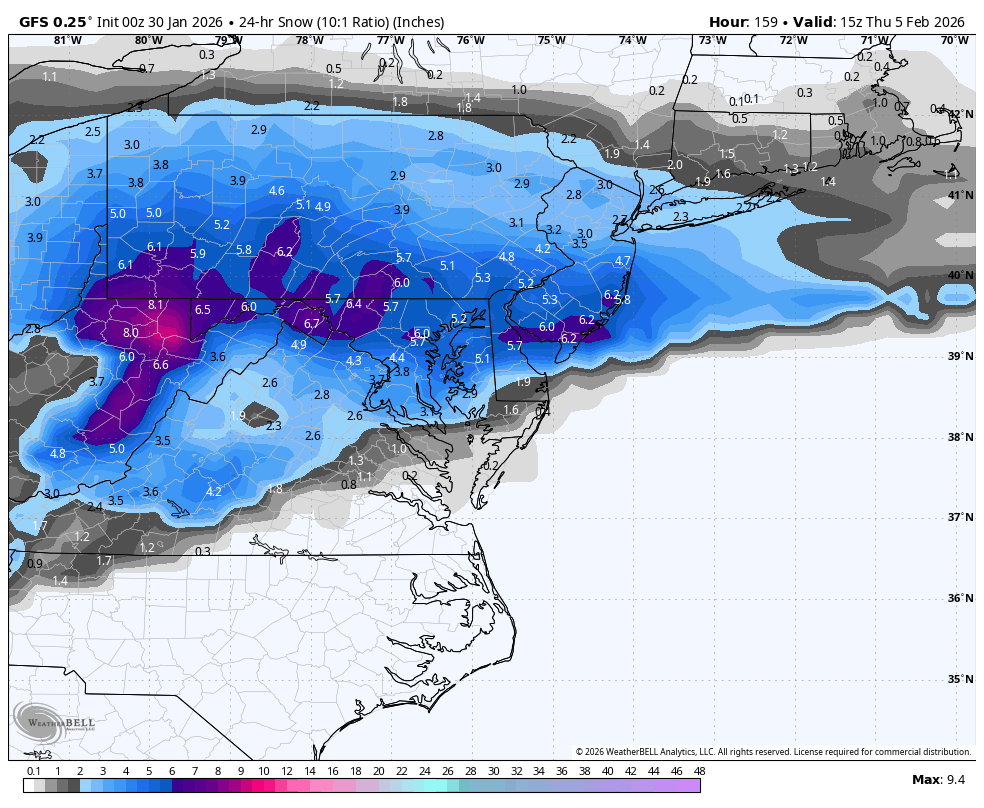
I realize this isn't our storm anymore but still painful differences in modeling for this storm down in North Carolina/southern VA. I'd probably look at the EURO AI and disregard all other guidance but tricky forecast for everyone minus eastern NC, which is the only part that seems consistently to get fairly consistently slammed.
-
Only thing worth kinda rooting for here for most of us is Boston getting screwed. Don’t have anything against the southern or eastern parts of our area or the Carolinas.
-
The “healthiest” way to like snow is probably just to look at the 7-day forecast and be thankful for what you get. Take a ski trip every year so you don’t get skunked. Problem is I don’t think there is any way out once you get in too deep. I’m sure even those who have left our forum still check in their own time. Might as well suffer together, IMO!
-
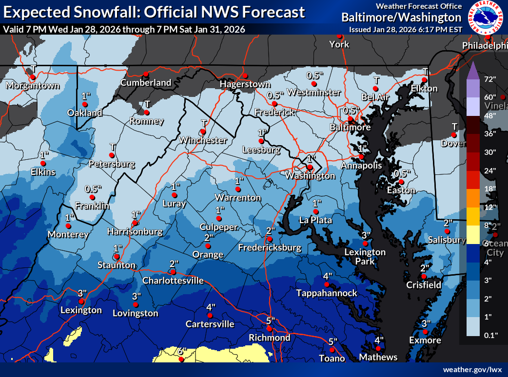
LWX bullish for our central VA/southern folks. Presumably some more to go here?

-
I like my idea! Everyone throws in a dollar, it’s a raffle ticket (so maybe you can enter several times), and we send one of us to Boston all-expenses paid. Easy. I’ll collect the money. Nobody worry about it.
-
You’re the smart one - having friends in snowy places! You don’t want to own a boat, you want to have friends with a boat…
-
Sounds like you could use a direct flight to Boston. This forum should crowdfund one weenie a ticket and a hotel to each blizzard, like $2 each.
-
I’ll try and lose graciously but I’d rather go OTS
-
You should know I'm a median lover! Just wasn't out yet. Lock it up