NorthArlington101
-
Posts
12,475 -
Joined
-
Last visited
Content Type
Profiles
Blogs
Forums
American Weather
Media Demo
Store
Gallery
Everything posted by NorthArlington101
-

January 2026 Medium/Long Range Discussion
NorthArlington101 replied to snowfan's topic in Mid Atlantic
CMC also kind of smokes us with the midweek refresher. Not to distract us from the larger dog -
January 2026 Medium/Long Range Discussion
NorthArlington101 replied to snowfan's topic in Mid Atlantic
-
January 2026 Medium/Long Range Discussion
NorthArlington101 replied to snowfan's topic in Mid Atlantic
who's got the big ones lock in early chart? -
January 24-26: Miracle or Mirage Thread 2
NorthArlington101 replied to mappy's topic in Mid Atlantic
Some really weird handling of the LP transfer. Sleet line evaporates down south as it tries (and fails?) to go off the NC coast before reappearing over all of Virginia as the MSLP eventually runs up the Apps. Idk what to make of it minus it's probably a toss. -
January 24-26: Miracle or Mirage Thread 2
NorthArlington101 replied to mappy's topic in Mid Atlantic
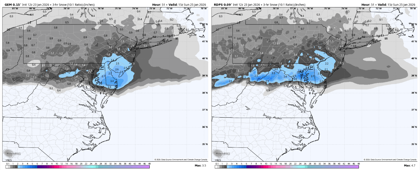
I'd post the CMC pretty maps but CMC/GEM and RGEM/RDPS are essentially the same model so why bother. Only big difference I see is the RGEM really slams us during the transition period, which is in line with how this usually goes.
-
January 24-26: Miracle or Mirage JV/Banter Thread!
NorthArlington101 replied to SnowenOutThere's topic in Mid Atlantic
Schools will close or delay for cold these days - of which there will be plenty regardless of a sheet of ice and snow. I find it pretty unlikely most of our wimpier districts have school next week. But tbd -
January 24-26: Miracle or Mirage Thread 2
NorthArlington101 replied to mappy's topic in Mid Atlantic
The GFS and the RGEM/GEM aren't world's apart. 3hr difference on the flip. Both pretty solid on the thump. If the EURO shows a 5-6" thump I'll chillax. -
January 24-26: Miracle or Mirage Thread 2
NorthArlington101 replied to mappy's topic in Mid Atlantic
Didn't realize how late the flip was for 6z... this is actually a bit earlier of a flip. Still later than most guidance. Hug to your heart's content. -
January 24-26: Miracle or Mirage Thread 2
NorthArlington101 replied to mappy's topic in Mid Atlantic
Doesn't want to flip D.C. til right after 1pm. Hope it's not the worst model in the world. -
January 24-26: Miracle or Mirage Thread 2
NorthArlington101 replied to mappy's topic in Mid Atlantic
Thump is wetter thru 6am -
January 24-26: Miracle or Mirage JV/Banter Thread!
NorthArlington101 replied to SnowenOutThere's topic in Mid Atlantic
Per NWS: Some of the variables that come into play include... Depth of the warm layer from the surface into the snow producing cloud. The warmer it is (closer to freezing), the lower the ratio will be. Amount of ice in the snow producing cloud. If there is more super cooled water droplets in the cloud, snow ratios will be lower. If there is a higher amount of ice crystals, snow ratios will be higher. If its windy, snowflakes can fracture, losing their "lacy" structure and leading to lower accumulations (lower snow ratios). Deep cold, in general, promotes higher snow ratios. -
January 24-26: Miracle or Mirage Thread 2
NorthArlington101 replied to mappy's topic in Mid Atlantic
Did nobody post the warning text for us? Wow, we really are fatigued. Don't blame anyone. Only gonna bother sharing the one for DC/Balt -
January 24-26: Miracle or Mirage Thread 2
NorthArlington101 replied to mappy's topic in Mid Atlantic
Yeah it's good. Significantly thumpy-er... general 5-6" OTG before 7am is what we need. Snows after that too if you buy it. -
January 24-26: Miracle or Mirage Thread 2
NorthArlington101 replied to mappy's topic in Mid Atlantic
4" of snow and sleet is still probably a good bar... I mean the 12k gets you 4" of sleet alone. -
January 24-26: Miracle or Mirage JV/Banter Thread!
NorthArlington101 replied to SnowenOutThere's topic in Mid Atlantic
Partially to preserve my own sanity and grind expectations low, but yeah, kinda because of the NAM. Also matches the EURO as far as snow goes, really, perhaps a tad more conservative. I guess the sleet would probably make my map wrong but I'll never really count that as snow even if you are supposed to -
January 24-26: Miracle or Mirage Thread 2
NorthArlington101 replied to mappy's topic in Mid Atlantic
Last negative nancy post then I'll try and dial it in - we keep pushing this storm back. It was a Friday night storm at one point! Now we're not really getting going til after midnight, and even then we don't seem to get rates til maybe 4am. Really, really, annoying. -
January 24-26: Miracle or Mirage JV/Banter Thread!
NorthArlington101 replied to SnowenOutThere's topic in Mid Atlantic
I'd probably add 1" to this and call it my forecast map atp for the most part. Ignoring far western zones and mountains. -
January 24-26: Miracle or Mirage JV/Banter Thread!
NorthArlington101 replied to SnowenOutThere's topic in Mid Atlantic
Crashouts? Who, me? -
January 24-26: Miracle or Mirage Thread 2
NorthArlington101 replied to mappy's topic in Mid Atlantic
FV3 is sexy and I can tell it's at least trying to filter out pure freezing rain. Dunno how it treats sleet. I'll pretend this was the NAM. -
January 24-26: Miracle or Mirage Thread 2
NorthArlington101 replied to mappy's topic in Mid Atlantic
Clearly the NWS wouldn't but I'm still happy to be concerned about it. Hate the NAM but when it stubbornly puts out a red flag we should usually pay attention. -
January 24-26: Miracle or Mirage Thread 2
NorthArlington101 replied to mappy's topic in Mid Atlantic
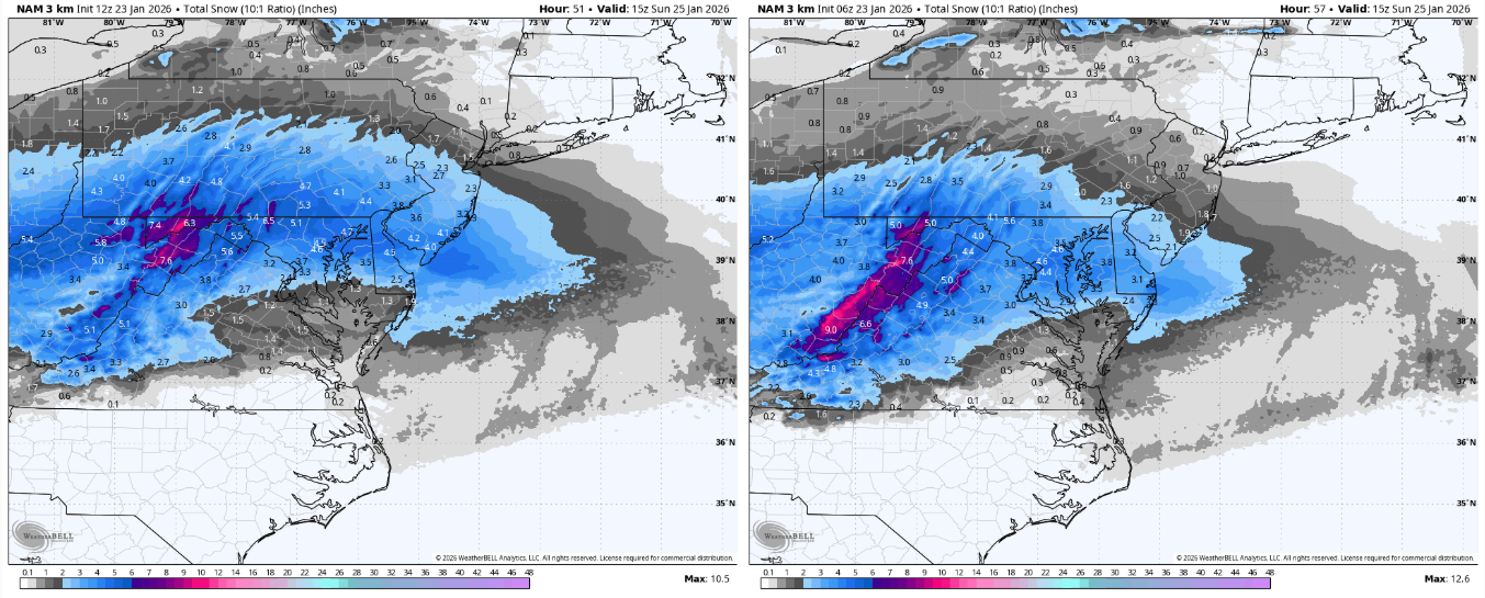
Nobody also tops 10:1 rates of .5"/hr on the 3k. It's not really a thump. -
January 24-26: Miracle or Mirage Thread 2
NorthArlington101 replied to mappy's topic in Mid Atlantic
I mean here is why I'm not happy regardless of whatever anyone says. Seeing the cushion to the SE of DC erode. We've still got like a day for this to fully evaporate. Doesn't work for me
-
January 24-26: Miracle or Mirage Thread 2
NorthArlington101 replied to mappy's topic in Mid Atlantic
I guess but if it's gonna race the sleet line up faster it comes out in the wash -
January 24-26: Miracle or Mirage Thread 2
NorthArlington101 replied to mappy's topic in Mid Atlantic
3k doesn't really look better to me. We hope and pray it's wrong. Starting down the barrel of less than warning criteria snow DC-south at this point. -
January 24-26: Miracle or Mirage Thread 2
NorthArlington101 replied to mappy's topic in Mid Atlantic