NorthArlington101
-
Posts
12,474 -
Joined
-
Last visited
Content Type
Profiles
Blogs
Forums
American Weather
Media Demo
Store
Gallery
Everything posted by NorthArlington101
-

January 24-26: Miracle or Mirage Thread 2
NorthArlington101 replied to mappy's topic in Mid Atlantic
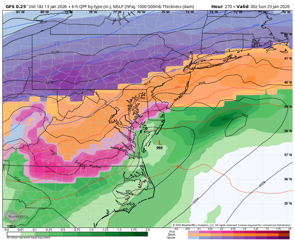
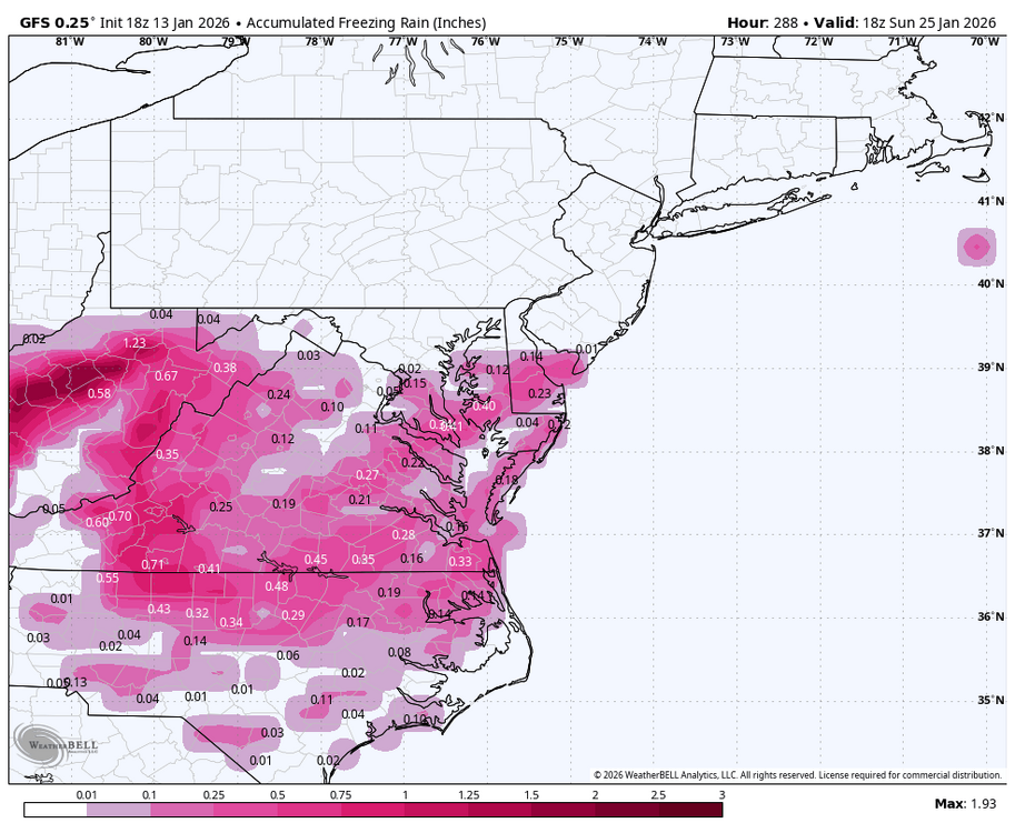
I'm honestly not that impressed - looks like .17" of precip for DCA from 42-45? We need more -
January 24-26: Miracle or Mirage Thread 2
NorthArlington101 replied to mappy's topic in Mid Atlantic
meh - next panel critical -
January 24-26: Miracle or Mirage Thread 2
NorthArlington101 replied to mappy's topic in Mid Atlantic
It is interesting that the HRRR models 850 as the more aggressive warm nose. Guess that would be worse for FRZA because there is less time for it to refreeze? Probably also not worth overanalyzing. -
January 24-26: Miracle or Mirage Thread 2
NorthArlington101 replied to mappy's topic in Mid Atlantic
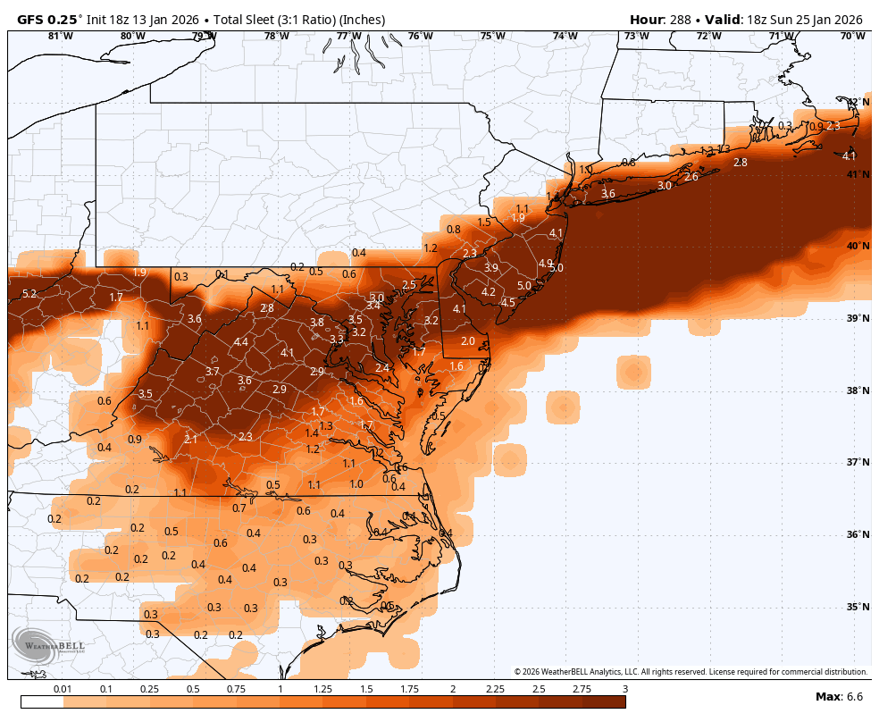
Believe this does include sleet, based on previous discussions in here. -
January 24-26: Miracle or Mirage JV/Banter Thread!
NorthArlington101 replied to SnowenOutThere's topic in Mid Atlantic
Feel like it’s EURO without the ability to discern sleet/snow/FRZA -
This may age pretty well


-
January 24-26: Miracle or Mirage Thread 2
NorthArlington101 replied to mappy's topic in Mid Atlantic
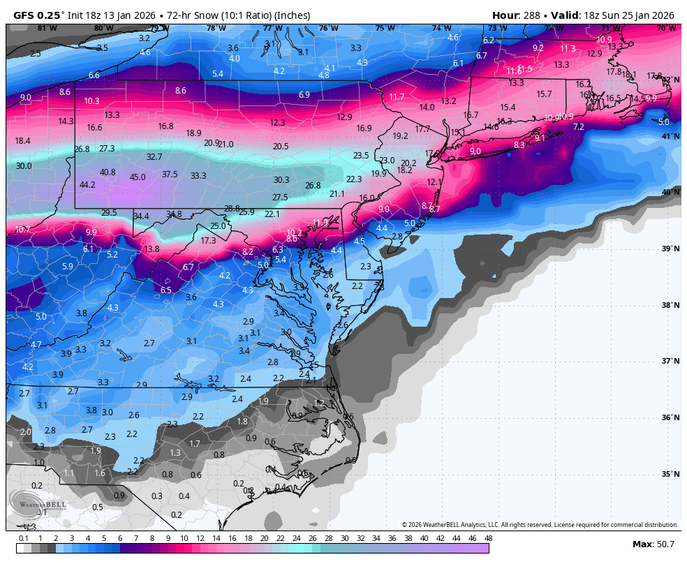
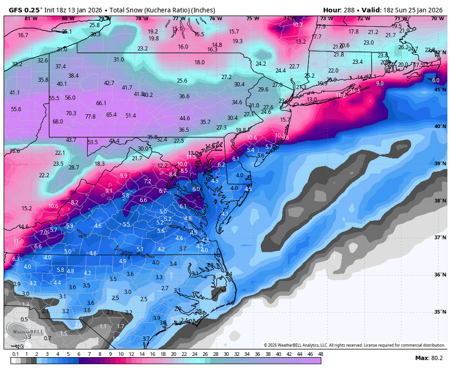
Fair - WxBell 10:1 maps have about half of that so I guess it likes the ratios, which isn’t crazy. Probably over analyzing the FV3 at this point. I’ll say you win -
January 24-26: Miracle or Mirage Thread 2
NorthArlington101 replied to mappy's topic in Mid Atlantic
I may have blinked and missed things today but I thought we were supposed to wake up to more than 2” at 6am. I’m willing to cave to being wrong, though. Guess every flake sticks even if it’s not heavy from midnight-6. -
January 24-26: Miracle or Mirage Thread 2
NorthArlington101 replied to mappy's topic in Mid Atlantic
It would probably be fine but it barely starts in DC until like 6am. Storm is gonna start Monday at this rate. This was supposed to start tomorrow night at one point! -
January 24-26: Miracle or Mirage Thread 2
NorthArlington101 replied to mappy's topic in Mid Atlantic
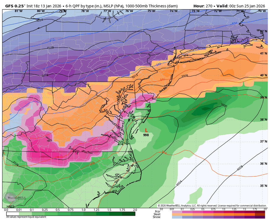
3k precip through 7am is anemic. Jeez. -
January 24-26: Miracle or Mirage Thread 2
NorthArlington101 replied to mappy's topic in Mid Atlantic
Unfortunately the ens seemingly can’t factor sleet/snow. Still a lot of total wintry precip -
January 24-26: Miracle or Mirage JV/Banter Thread!
NorthArlington101 replied to SnowenOutThere's topic in Mid Atlantic
Thanks to @nw baltimore wx and @nj2va for joining me for a happy hour! Always nice to meet more folks. Cheers to all models caving to the GFS -
January 24-26: Miracle or Mirage Thread 2
NorthArlington101 replied to mappy's topic in Mid Atlantic
Post was in reference to a digital snow run that had 4” of sleet and not a lot of snow. 7 days ago that was an epic fantasy run. Now we’re all mad about it (not all, but ya know) -
January 24-26: Miracle or Mirage JV/Banter Thread!
NorthArlington101 replied to SnowenOutThere's topic in Mid Atlantic
Well I only checked because it screamed robot to my human brain. I don’t do that to everyone’s posts (though maybe I should) -
January 24-26: Miracle or Mirage Thread 2
NorthArlington101 replied to mappy's topic in Mid Atlantic
I’m on mobile so I can’t move this to banter but it’s HILARIOUS how this was an awesome, epic fantasy run and now we’re gonna be miserable if this is the outcome. Perspective shifting, honestly -
January 24-26: Miracle or Mirage Thread 2
NorthArlington101 replied to mappy's topic in Mid Atlantic
meh too slow - no map before hr96 is real!! -
January 24-26: Miracle or Mirage Thread 2
NorthArlington101 replied to mappy's topic in Mid Atlantic
Looks like my job got stolen. I'll let @SnowenOutThere post the final totals at hr96. It did cut back a bit near Richmond/SE Virginia, so it's hopefully the start toward a compromise-ish solution? But technically it's better than 12z, so I guess the camps widened in some respects. -
January 24-26: Miracle or Mirage Thread 2
NorthArlington101 replied to mappy's topic in Mid Atlantic
Gonna give ya'll the pretty maps then go meet @nw baltimore wx and @nj2va at a happy hour... still not too late to join us at Succotash in 20m! -
January 24-26: Miracle or Mirage Thread 2
NorthArlington101 replied to mappy's topic in Mid Atlantic
Correct -
January 24-26: Miracle or Mirage Thread 2
NorthArlington101 replied to mappy's topic in Mid Atlantic
sleet line doesn't really move from here the rest of the run -
January 24-26: Miracle or Mirage Thread 2
NorthArlington101 replied to mappy's topic in Mid Atlantic
DC flips by 78 but we'd still be happy. 8" non-Kuchera. -
January 24-26: Miracle or Mirage Thread 2
NorthArlington101 replied to mappy's topic in Mid Atlantic
Precip looks to end up delayed not denied - wetter at 72 -
January 24-26: Miracle or Mirage Thread 2
NorthArlington101 replied to mappy's topic in Mid Atlantic
Looks a bit slower toggling back and forth on WxBell. But like an hour or two. If you think it's drier you are probably also right -
January 24-26: Miracle or Mirage JV/Banter Thread!
NorthArlington101 replied to SnowenOutThere's topic in Mid Atlantic
Glad to know I can still detect a robot
-
January 24-26: Miracle or Mirage JV/Banter Thread!
NorthArlington101 replied to SnowenOutThere's topic in Mid Atlantic
I think this hobby suffers from the same issues that plague the world -- too much information, a rush to be first, a drive toward saying polarizing things to get attention. I can't come up with a solution to any of these problems other then some slight unplugging. I'm not sure there was a way to have watched this storm and not feel at least a little rugpulled/frustrated, though. Sometimes that just happens.