USCG RS
-
Posts
3,010 -
Joined
-
Last visited
Content Type
Profiles
Blogs
Forums
American Weather
Media Demo
Store
Gallery
Everything posted by USCG RS
-

Southern Crippler - Get well soon Jimbo Storm Obs
USCG RS replied to BooneWX's topic in Southeastern States
MDBR...? -
Southern Crippler - Get well soon Jimbo Storm Obs
USCG RS replied to BooneWX's topic in Southeastern States
For the record, your avatar is perfect for you -
Unfortunately that's really all it is at this point. Pray we're wrong and be ready. Check on neighbors. Use judgement and be safe.
-
Based on everything I've seen... Current observations, models which have been handling this storm well, cold air digging in, I believe he is. As I've said... From a risk management perspective, this is a pull out all the stops situation. Even if it ultimately turns out to be wrong
-
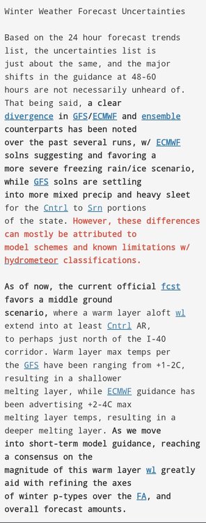
If this is RGEM vs NAM, I would rely on the RGEM. I always have in these set ups, granted I'm originally from up North. That withstanding, the NAM has consistently been warmer than observations and North with placement of moisture concerning what we have been seeing over towards Texas and the Midwest. Could it miss the areas in a warning? Sure. That'd be great. No one wants an ice storm, especially a crippling one. But right now that's the expectation and to say it ain't coming is pure speculation. Because at best it's 50/50 it misses. In reality the chances are much lower than that that we don't take at least a significant hit from this storm.
-
Same here. I don't see it. But I'd love to eat a buffet of Crowe on this one
-
Great analysis
-
I'd look at real world observations upstream vs simulated outcomes for each model. That will give you an idea of which model is handling things better.
-
Upstream AFD (Little Rock AR)
-
I agree with one, as others have Unless it's in the 20s. While I desperately want the NAM to be correct, the NAM is consistently running warm with this storm compared to real world observations So it's likely missing the density of the cold air leading the LP to do whatever it wants. I don't think that's realistic. It's going way too far North with the warm air and acting like there's nothing in its way. This would also translate to its dry slot. Also, as I've been kind of harping on, RGEM is significantly cooler which gives me further pause.
-
RGEM is inside of its deadly range and is normally pretty good with temps and P Types.
-
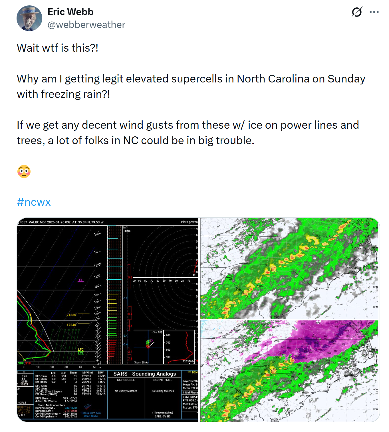
https://x.com/webberweather/status/2014898329558384816?s=20

-
-
I would argue its both. As others have mentioned even with very light qpf, which is undermodeled many times, its still accruing.
-
Put a blink camera in and take a ride...
-
Simpsonville SC here
-
If you look over the Texas region, its been colder than expected. Likewise, this HP is really nosing down with a very dense cold. Perhaps it allows for more sleet than ZR, but, historically with these set ups, its a nortorious set up for ice in this region. I would say sleet may be a saving grace, however, I would not think that RN (plain) willl be.
-
It comes down to liability. People are afraid to make a call and be wrong. Again, from a Risk Management point of view, I am actually sounding an alarm and have been to those I know and advise. The truth is we dont KNOW what will happen. However, there is a high probability of a significant ice storm. There is a medium to high possibility of a crippling ice storm. There is a moderate possibility of a catastrophic ice storm. From a Risk Management perspective, this is where you plan for severe disruption and pray you are wrong. But, if there was any WINTER storm where I would pull out the stops, its this one.
-
Unfortuntely 0.25 inches of ice is about 250 lbs added to each power line (per 300 feet of span), 0.5 inches about 550 lbs and one inch about 750-800 lbs. If we hit 2 inches (just throwing it in because of how crazy a jump in the weight is) - its about 2,250 lbs. Now - Distribution lines (NOT residential lines and/or service drops) are designed to handle a half an inch of ice accumulation and transmission lines are designed to handle 1.25 inches if made and maintained to standard. So we are actaully within potnetial range of BOTH (1.25 inches if we hit the very high end guidance - not necessarily likely). Keep in mind, winds kick up after the storm, which adds signifcant force to an already overburdened line. Likewise, any older infrastructure is likely to fail under standards. This could be.. well we all know what it could be.
-
That is exactly what is concerning me. Its actaully giving me a good bit of anxiety because this could be really rough from that point of view.
-
100%.
-
The truth is that any restaurant, company, etc that would do this to an employee is not a company that deserves to have employees. I know that it is not always easy to say I am not doing something, but as someone who usd to work in a restaurant, I implore you that if you call out and the peanlize you, find another job. I actually had this happen when I worked as an EMS provider and the county I worked for asked me to stay as a tropical storm was bearing down on the area. I called and expained and they stated that the weather was not that bad and that I had a choice to make. I was let go and it was the best thing that could have happened to me. Speaking as a Risk Manager - here is my two cents: The forecast, if it plays out, is significant to major. I hate to ever use this word, but if we hit the 90th percentile of forecasts for this ice then it becomes catastrophic in some areas. So, at the end of the day, you have to prioritize yourself and your family. If you are stuck at work, your family is fending without you. If you try to make it home and were in the middle of a massive ice storm, chances are you simply wont. This has the potential to cripple the area with roads being impassable for days if we are hit as expected. So the matrix of Risk is such that we are facing a very high impact event with a significant strain on resources and a likely inability of the municipality to respond in a meanigful way for an extended period of time. You may have a choice to make, I would ask that you use this reasoning to help you come to a decision. Be safe.
-
Yeah... Upstate SC looks like it's taking this on the chin.
-
Yeah, I think models are still figuring out just how dense this cold air is. If it's just dense enough, you get it just high enough to switch from ZR to IP. Here's hoping.
-
Can you imagine GSP - 1-2" of ice this week. 24-36" of snow next. That's... I mean this is fantasy land but.... Damn