USCG RS
-
Posts
3,010 -
Joined
-
Last visited
Content Type
Profiles
Blogs
Forums
American Weather
Media Demo
Store
Gallery
Everything posted by USCG RS
-
Im sorry to everyone in Raleigh... I know how much this stings. Im still hoping for a miracle for you guys.... maybe the storm blows up a bit more...
-

The “I bring the mojo” Jan 30-Feb 1 potential winter storm
USCG RS replied to lilj4425's topic in Southeastern States
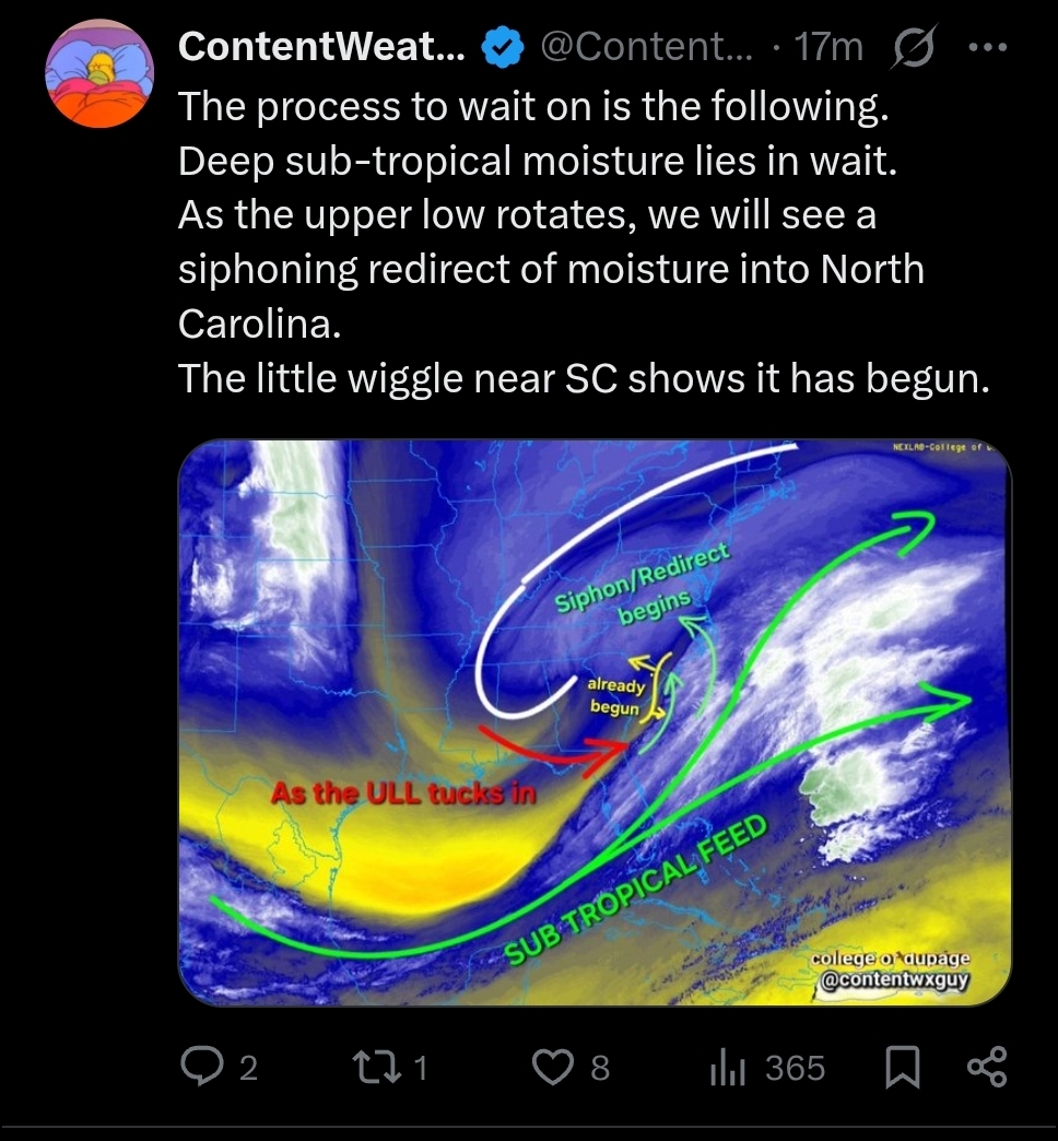
https://x.com/ContentWxGuy/status/2017622514646602106?s=20
-
January 30th- Feb 1st ULL and coastal storm obs
USCG RS replied to JoshM's topic in Southeastern States
https://www.ventusky.com/wind-speed-map/10m-above-ground#p=32.6;-75.6;5&t=20260131/0300&w=0xIAb9A9A -
The “I bring the mojo” Jan 30-Feb 1 potential winter storm
USCG RS replied to lilj4425's topic in Southeastern States
Thats.. Well thats new. -
The “I bring the mojo” Jan 30-Feb 1 potential winter storm
USCG RS replied to lilj4425's topic in Southeastern States
I actually was in your neck of the woods last week to escape the non existant ice catastrophe up here. Never been before. Beautiful town. -
Remember, get hit by the expensive cars only. Better likelihood at a payout
-
The “I bring the mojo” Jan 30-Feb 1 potential winter storm
USCG RS replied to lilj4425's topic in Southeastern States
I have this fight with OEM alot. -
The “I bring the mojo” Jan 30-Feb 1 potential winter storm
USCG RS replied to lilj4425's topic in Southeastern States
So with ULL slowing, I wonder if the CAMs are putting that together with a very dry h5 and shearing this out. We already discussed the h5 being dry but h7 being high with regard to RH. But.. I do wonder if the CAMs see the ULL as too slow.. But that wouldn't make synoptic sense because you can see how it's already affecting and being affected by the storm. -

-
The “I bring the mojo” Jan 30-Feb 1 potential winter storm
USCG RS replied to lilj4425's topic in Southeastern States
At this point, pretty much no one is or has been consistently right. -
The “I bring the mojo” Jan 30-Feb 1 potential winter storm
USCG RS replied to lilj4425's topic in Southeastern States
RGEM is normally a superior model. Unfortunately, I am not well versed enough with this area to say why I would or would not believe the RGEM, but in the NE it was normally pretty deadly from 30hrs and below. -
At this point... Btw... We might as well just let the storm play out and see what happens.
-
I'm a literal risk manager... Two major busts in a row for warning.. Boy who cried wolf... Granted... I'm not cliff diving rn. Also. I've made some big calls and busted in forums before. I just keep my fridge stocked with Crowe and show back up. But some would say I'm a glutten for punishment. And by some I mean all.
-
If we truly do bust like this... That would be wild
-
The “I bring the mojo” Jan 30-Feb 1 potential winter storm
USCG RS replied to lilj4425's topic in Southeastern States
If this were to bust... The public themselves might riot. -
The “I bring the mojo” Jan 30-Feb 1 potential winter storm
USCG RS replied to lilj4425's topic in Southeastern States
Listen Mojo. Don't you quit on me now. -
The “I bring the mojo” Jan 30-Feb 1 potential winter storm
USCG RS replied to lilj4425's topic in Southeastern States

-
Slower *should* help the western areas. More time to pull back West, consolidate and expand.
-
The “I bring the mojo” Jan 30-Feb 1 potential winter storm
USCG RS replied to lilj4425's topic in Southeastern States
Nice to see you down this way -
The “I bring the mojo” Jan 30-Feb 1 potential winter storm
USCG RS replied to lilj4425's topic in Southeastern States
https://x.com/ContentWxGuy/status/2017383442699190326?s=20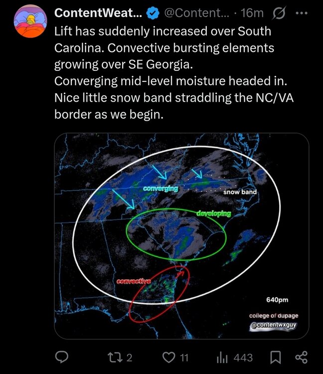
-
The “I bring the mojo” Jan 30-Feb 1 potential winter storm
USCG RS replied to lilj4425's topic in Southeastern States
https://x.com/ContentWxGuy/status/2017384586540417531?s=20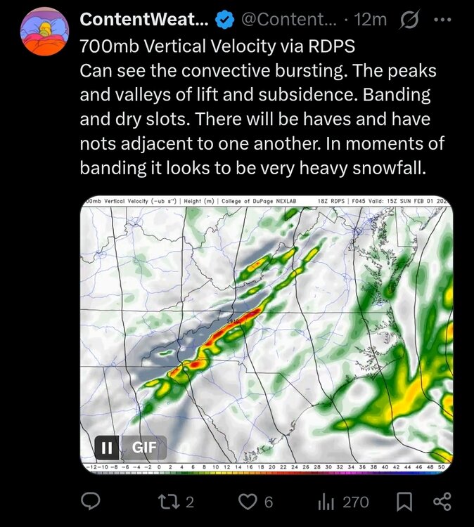
-
The “I bring the mojo” Jan 30-Feb 1 potential winter storm
USCG RS replied to lilj4425's topic in Southeastern States
Greenville County (Simpsonville) -
The “I bring the mojo” Jan 30-Feb 1 potential winter storm
USCG RS replied to lilj4425's topic in Southeastern States
This. We need more of this from meteoroligcal outlets. -
The “I bring the mojo” Jan 30-Feb 1 potential winter storm
USCG RS replied to lilj4425's topic in Southeastern States
(2).jpeg.b013e824a045ebc352c6b2c1669f2bc0.jpeg)
-
The “I bring the mojo” Jan 30-Feb 1 potential winter storm
USCG RS replied to lilj4425's topic in Southeastern States
HRRR at 32 hrs is a stretch. It's not always wrong, but it's a short range model designed for really 12-18 hrs out at most. If that look is real, I would not be surprised to see this be pretty dry forum wide. But based on how the storm is already developing, I would say this is not going to develop and be shunted further East like the HRRR appears to be showing.