USCG RS
-
Posts
3,010 -
Joined
-
Last visited
Content Type
Profiles
Blogs
Forums
American Weather
Media Demo
Store
Gallery
Everything posted by USCG RS
-
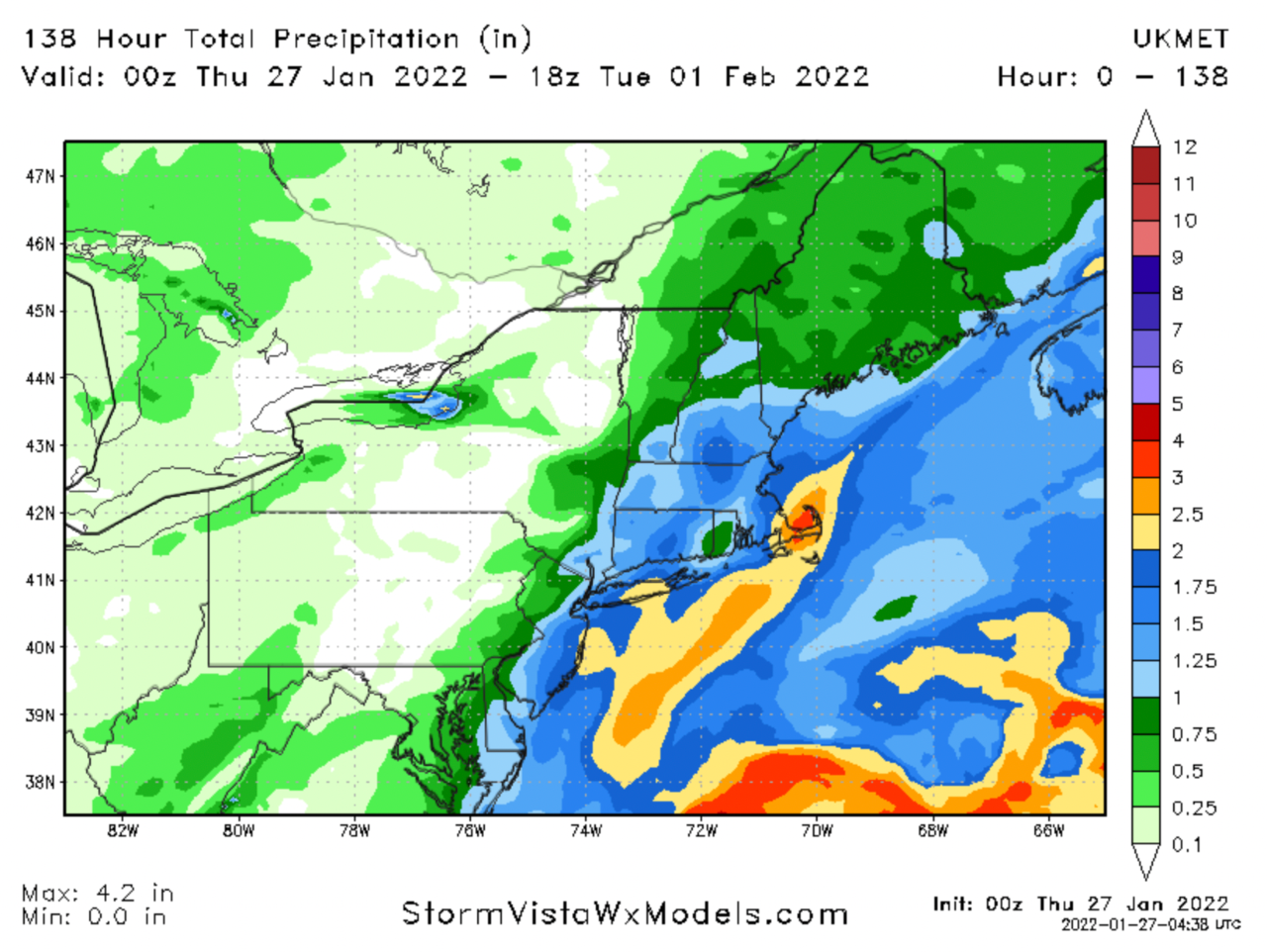
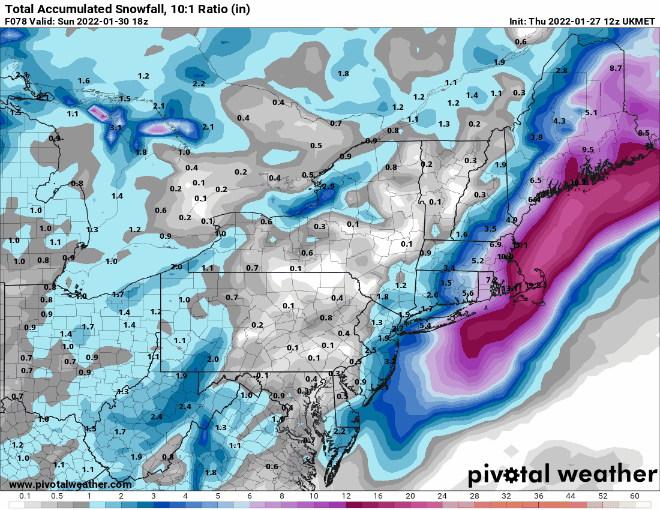
I hate to use this, but, convection chasing. This closes, shunts east towards convection and recloses. Now, of course a sloppy phase can do this, however, the model verbatim looks to be chasing. That H5 should have buried NJ to N. England.
-
Euro is a bomb. That verbatim, would have been tucked, I do not care what the surface shows. H5 shows that would been a KU.
-
We will see afterwards if the GFS was correct. However, I will add that precision and accuracy do not always go hand in hand. In fact they rarely do.
-
-
Yeah... this is a complete nowcast situation, unfortunately. A phase of 3-6 hours earlier, OR a slight different orientation of the trough OR a different phase going into the trough OR... etc. So many moving pieces. So many.
-
You're not too far off tbh. Some of the experts have more of an idea of what they think is going to happen, however -after discussions- you are not too far off. Which makes sense for this particular storm.
-
100%. However -to me- the GFS is going to be stubborn here. So these baby steps on the GFS are pretty big to me. I keep drilling this, but the H5 is incredibly close to something special. It really is.
-
It is very real. The issue it is showing is the lack of a clean phase. You want this to consolidate much more quickly. If the Northern vort phases in/consolidates and/or the trough tightens a bit, then this double barrel low either does not show up or quickly consolidates to the westernmost low.
-
No one sees the improvements at H5 on the GFS? No one at all?

-
Yeah.. That's I've been basically saying when asked.. 3-6 hrs is the whole ballgame.
-
Exactly
-
It's the phase. It's not chasing here. The phase isn't as clean because the trough is not as tight as we would like it. The phase takes longer and is sloppier, so it's broader and then finally completes and the SW low is allowed to consolidate
-
Yes. We are still very very close to something much bigger for the entire subforum.
-
Is so close. But.. Euro like with the broad trough.
-
It needs to tighten** so it can sling shot. Is very close.
-
Because the models are having significant issues with H5. The standard room for error at h5 encompasses some of these potential changes. One slightly different phase and your whole storm is different. Can't always just take models lock stock and barrel In theory... High resolution short range models should have your best shot here
-
We should be getting NAMed again
-
That is the same with OEM.
-
No, you really can't. Not to mention.. Municipalities need to have time to prepare
-
Again.. It's all about the phase. When and where they happen will dictate it all. H5
-
Ukie
-
The GFS is more than likely to not come around until the last minute. Likewise, this is not the GFS wheel house. If it is the GFS alone, you will have several very well respected models vs a global at short range.
-
If the Ukie truly did come West, I think we have our answer.
-
I do alot of work with the Red Cross regarding EM, etc. So.. nice to formally 'meet' you.
-
Ah ok, I knew I knew your name from somewhere in the city.