

USCG RS
-
Posts
3,010 -
Joined
-
Last visited
Content Type
Profiles
Blogs
Forums
American Weather
Media Demo
Store
Gallery
Everything posted by USCG RS
-
You work with NYC OEM correct? Maybe not for them.. but hand in hand, no?
-
Worse.
-
Out of my depth with that one
-
I may have jumped the gun there... but that H5 -if it comes to fruition- will disappoint no one here. I can't remember seeing that type of H5 on the models since I started tracking... about 20 years ago.
-
I believe the crawling monster is very possible, if not likely (not sure about that low a mb but), however, those on Long Island should also prepare for what comes along with that.
-
Beyond. That was... something.
-
If that was depicted correctly.. thats a KU NC to BOS. Thats a bomb.
-
Buckle in. This is about to get wild on the NAM
-
Positively lol. I have never seen it used for negative reasons, well... it means its going crazy, but in a good way.
-
The PNA ridge ebbing up and down has been able to cut off the southern stream energy there. The progressive pattern allows for the ebbing and flowing, while also cutting off some energy in the four corners region.
-
We are about to get NAMed. Again.
-
You can feel the whole forum holding its breath
-
At hr 36 you can see the southern stream is much better and being allowed to interact with the Northern stream. This is much better. Orientation is better as well.
-
Honestly, I'm really about all in on this. The H5 is so close to something spectacular on just about every model.
-
What you said about the Kuchera Yeah, I should have posted the 10:1 maps also and then said to average. A bit distracted earlier though. Welcome to emergency management issues (was actually trying to reply to what you said @Volcanic Winter) I told you - it's coming Exactly. Someone else understands me! Not at all. H5 is a hairs breath away from something truly spectacular.
-
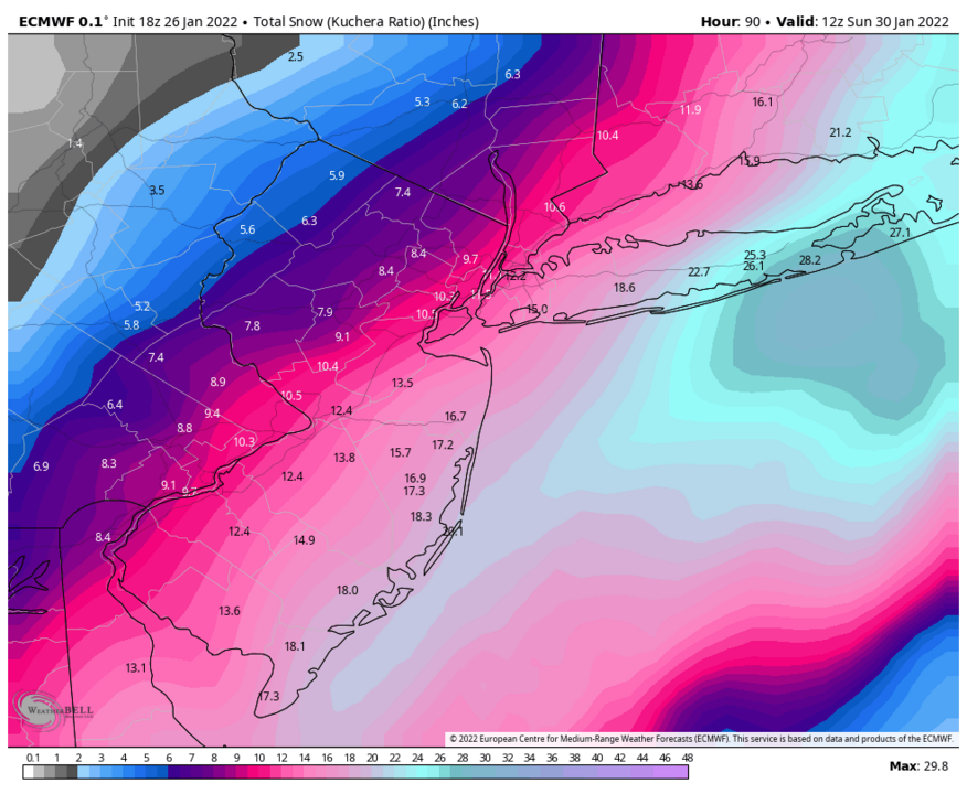
Kuchera
-
Wow. Suffolk County is buried by 18z Euro.
-
H5 was a hairs breath away from something much more significant. Northern stream much less suppressive, heights were allowed to rise. Southern stream was actually allowed to eject. We are close. So close.
-
I did not realize that change aloft.. so my bad lol
-
Wow..
-
Big shifts at the surface are -in reality- very small shifts at H5. All is not lost.
-
I have been saying this all along today....
-
H5 much better this run. Sfc goes the opposite.
-
I'm probably going to be labeled as crazy, but, we're not that far away from a much stronger solution, even with the 18z NAM showing what it is showing. The H5 phasing rules this entire storm and there is so much energy bouncing around, that models are going to have quite the hard time handling it. I would say just sit tight. We're not done yet.
-
A few things 1) Anyone writing this off is wrong. Could it trend the wrong way? Yes. However, everyone needs to take a step back and breathe. We are 72 hours out and the H5 is incredibly close this run, even for the GFS. 2) As has been stated, the sfc LP is dropping from 998 to 984 mb inside of six hours (and likely a conservative drop). As such, the lack of precip expanse to the NW and the it jumping East, gives me great pause. However, I have more pause due to the fact that at that time, the H5 is closing off. Something is wacky there. Of course, the H5 can always open up again and without the Southern stream energy as involved, there is a bit of a higher risk for that. However, it still must be understood that the likelihood of what is being shown verbatim is not high. 3) A jump east still gives many a SECS. 4) Everyone... Relax. (Psh. Like thats gonna happen)


