

MillvilleWx
-
Posts
4,423 -
Joined
-
Last visited
Content Type
Profiles
Blogs
Forums
American Weather
Media Demo
Store
Gallery
Posts posted by MillvilleWx
-
-
30 minutes ago, psuhoffman said:
I’m not saying the snowless streak will go on that long. For the record I think the snowlessness is a combo of bad cycle and warming. We likely get a somewhat better period at some point even with warming.
But let’s say it doesn’t improve. What if we continue at the same snowfall rate we’ve had on avg the last 8 years where DC is averaging about what Charlotte NC or Spartanburg SC should! How long do you think before those denying the climate has changed come around? 2 more years? 5 more years? Are we in 2040 and it’s been 25 years since Baltimore had a 6” snow and they’re still saying it’s just bad luck and we will turn it around any day now?
Never
-
 1
1
-
-
12/19 - T
1/6 - 0.75"
Total - 0.75"
-
1 minute ago, MN Transplant said:
Unfortunately, yes.
I would absolutely think that was possible. Decembers are not good for here in Ninos historically, and the pattern usually isn't snowy in the means until mid-Jan, so definitely would believe someone. Also, this is the Mid-Atlantic. We fail better than anywhere east of the Mississippi. We aren't used to it after a mega decade long heater in the grand scheme.
-
Over 2" at my place with the rain coming to an end. Solid event. I've seen more rain in 5 months than I have in two years combined in west TX
-
 5
5
-
-
8 hours ago, Eskimo Joe said:
Day 2 mod risk of flooding from WPC.
You’re welcome

-
2
-
15
-
 1
1
-
-
This shift tonight was crazy busy. Here's all the thoughts on the rainfall and flooding risks over the next 3 days.
https://www.wpc.ncep.noaa.gov/discussions/hpcdiscussions.php?disc=qpferd
Enjoy any feedback on the write-ups")
Look for 330AM time stamp
-
10
-
 11
11
-
-
1 minute ago, North Balti Zen said:
Having a hard time cherishing it, Millville...it has been really disappointing for quite a long time now up this way. This is yet another kick in the nethers. Can't even get pity snow to fall just to give the illusion of snow anymore. And I live in the Hereford Zone now.
Glad you are feeling better.
Totally understand. A lot is perspective and relative senses. I endured a lot of rainless periods living in West TX and as nice as the days were, seeing everything dead was just awful. I will embrace precip in any form from now on. The pattern will be getting colder mid month moving forward. Hopefully we can track a decent event after it occurs. I still have positive hopes for the season.
-
4
-
-
Just woke up not too long ago. Hovering at 32° 5N Frederick
Got a slushy 0.5-1” while I was asleep it looks like with RN/IP right now. I know it’s not a lot, but seeing some snow on the ground being back east is a glorious sight.
Congrats to those to my north and west. Hopefully the snow keeps on for a bit and we some 5+” totals verify for some of the sub forum.
My URI seems to be improving slowly. I’ll take that as a win as well.
PS: I know many here hate seeing rain, especially when it could be snow, but coming from a place where we went 13 months without eclipsing 1 total inch cumulative for that time…cherish it! It's so much worse not seeing anything for long periods time than it is to see it happen frequently.
-
6
-
-
27° 5N Frederick as I crawl into bed. Looking forward to seeing a little white on the ground when I wake up. Might be ZR by then, but it’ll be nice to get on the board, even with a little.
Good luck to all today
-
4
-
2
-
-
1 minute ago, pazzo83 said:
Temps steady in Tenleytown (~380ft) at around 34F for the past few hours. 34/35 at DCA.
I know what you're referencing in the temp being around 34 to 35 at DCA, but if this was a temp/dp...I would still believe you because if anyone can defy the laws of thermodynamics, it's DCA
-
1
-
13
-
-
Almost freezing here in north FDK. I’m expecting 2-4" for my place tomorrow. Hoping for a surprise. I just want to get over this dang URI. Draining me and being on nights doesn’t help
-
7
-
-
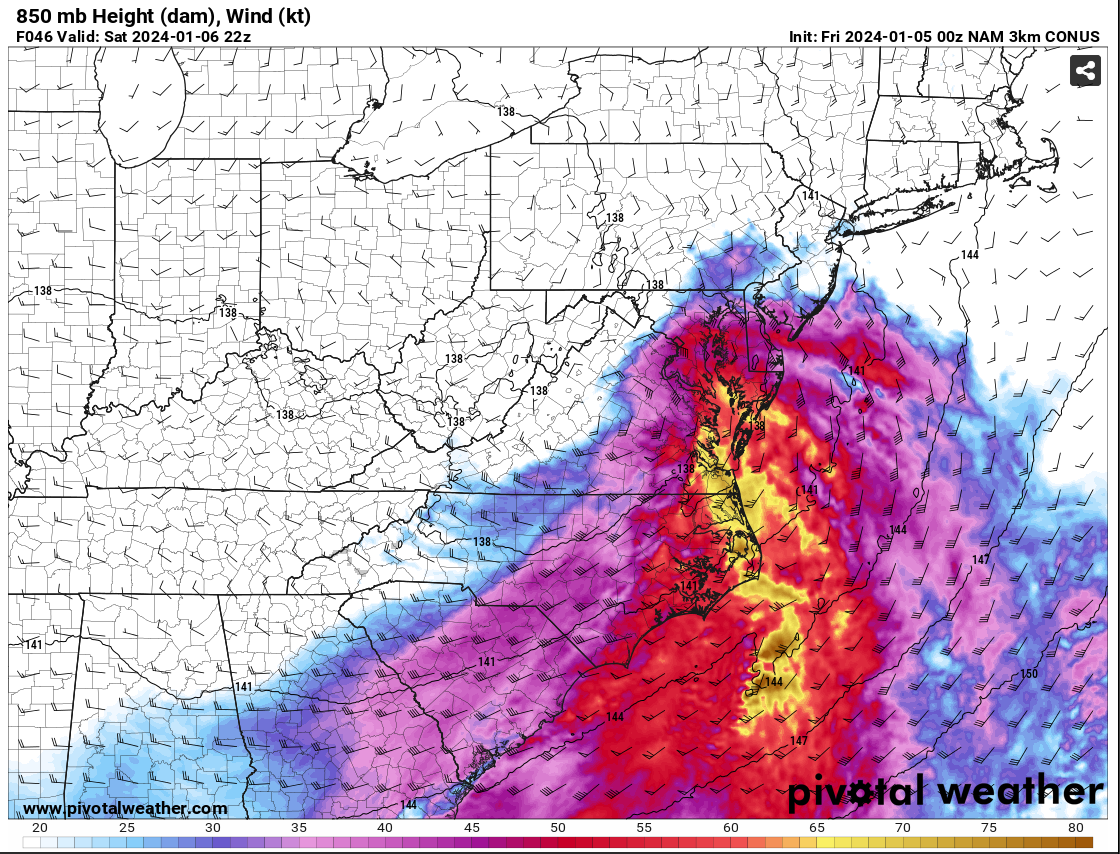
The reasoning for the shift in the colder solution on the NAM is the development of a closed 850mb low tracking south of the Potomac over north-central VA. Pay close attention to the wind barb across the northwest area and how the 850mb southeasterlies hit a brick wall over Parrs Ridge and the wind direction flips. This would allow for cold air to advect into the northern and western side of the circulation creating a more beneficial PBL and keep everything frozen, or even all snow. Check out the wind barbs to the east of RNK...
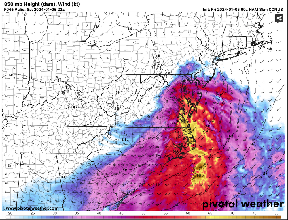
As a result, watch the 850mb temp profile as we work through time. This is actually how you get surprises and periods of heavy snow when you weren't expecting.

MAJOR CAVEAT.... THIS IS JUST ONE RUN OF ONE MODEL!!!
We are going to want to see other guidance pull this off and have it become something to watch. This could be a one run and done deal, but there is potential for this. I will not be committing anything until I see some agreement from other guidance. It was interesting to see and point out as a possibility. It would affect the forecast in a big way. These are why these marginal events are so tricky. One thing can make or break a forecast. Let's hope it's right. Right now, no changes from my current thinking.
-
18
-
11
-
-
Well, been a fun few days for me. Good news, tested negative for Covid. Bad news is it’s still a tough URI to deal with.
I haven’t had too much to add to what’s already been said. I’ll try to have a map out at some point. If not, I’ll list towns with my forecast and you can gauge from that.
I like @Ellinwood map and would likely be very similar to mine, so you can use as a proxy.
-
11
-
-
27 minutes ago, clskinsfan said:
Its a 3-5/4-8 type thumper. We havent had one of those for a while. I am looking forward to it.
This is very much what I’m leaning right now. I’m still curious to see the PBL on soundings when we get to Nam Nest and hi-res range. That’ll help out tremendously in the snowfall forecast.
Edit: This is more for NW of the fall line with the best chance north of I-70 and west of US15. I’m leaning 1-2” in the district with a small incremental increase the further NW you go.
-
4
-
-
700mb Verticial Velocity
-
10
-
-
Just now, brooklynwx99 said:
love to see the confluence make a notable shift stronger on both the GFS and CMC so far. increases surface HP strength and compresses the flow so that even a weaker S/W has more bang for its buck AND is colder

The run was really positive to see with the newer 00z data ingest. I actually loved seeing the 5H progression of the trailing wave getting into the action late Sunday into Monday with light snow continuing over the MA. That will be something to monitor, but the primary shortwave passage was fantastic for a quick thump over a span of 8-12 hrs.
-
8
-
-
The 7H VV panels on the GFS are what @psuhoffman would take somewhere in privacy
-
5
-
13
-
1
-
-
This setup is reminding me of a few moderate events we've had in these parts back in the 2010's. Most famous was the December storm that crushed the area and gave the Ravens snow game vs Minnesota. Snow came in like a wall, which is what the GFS is advertising now in successive runs. Quick storm, but a nice thump from a decent WAA regime.
-
9
-
-
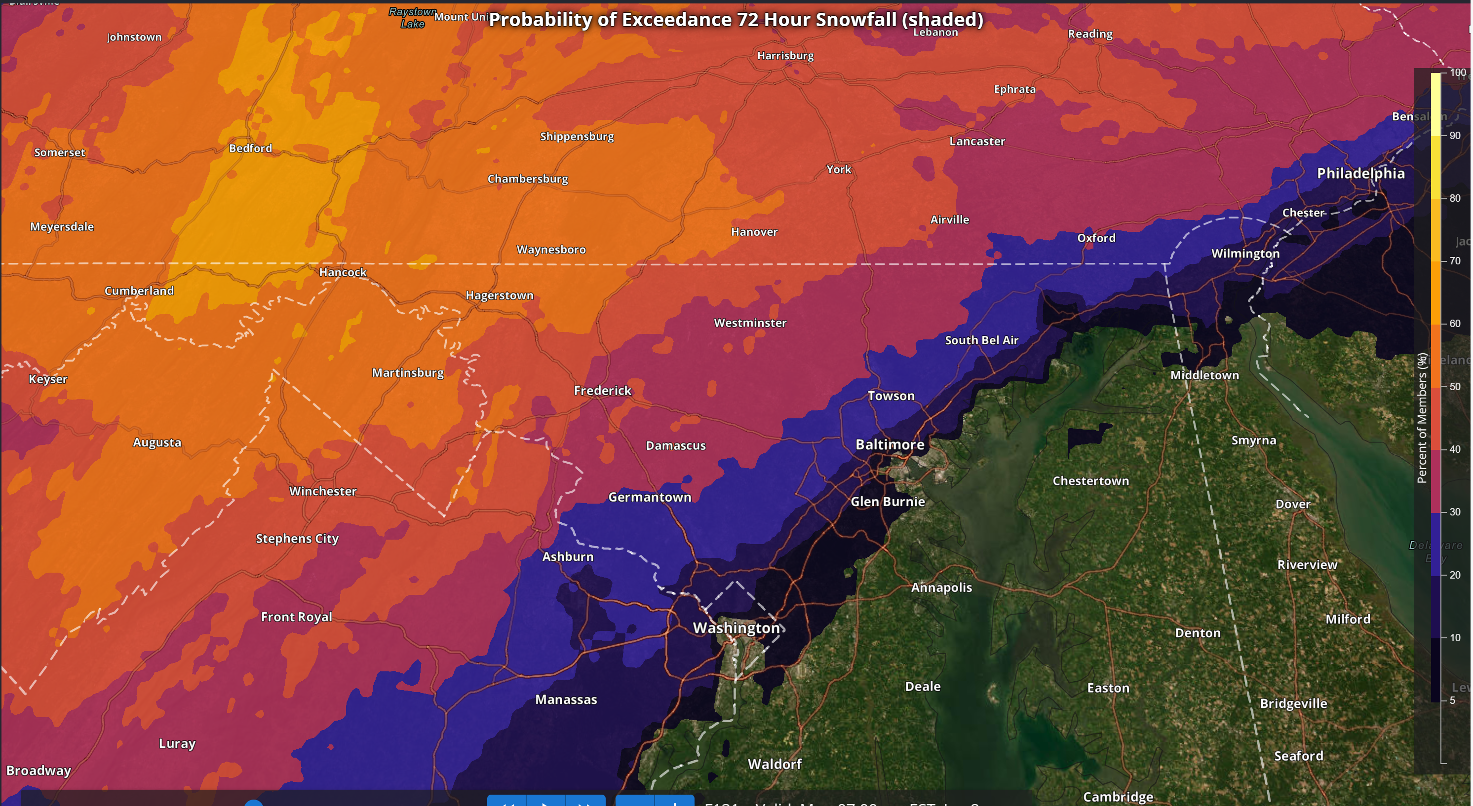
Latest NBM Probabilities
>= 3"
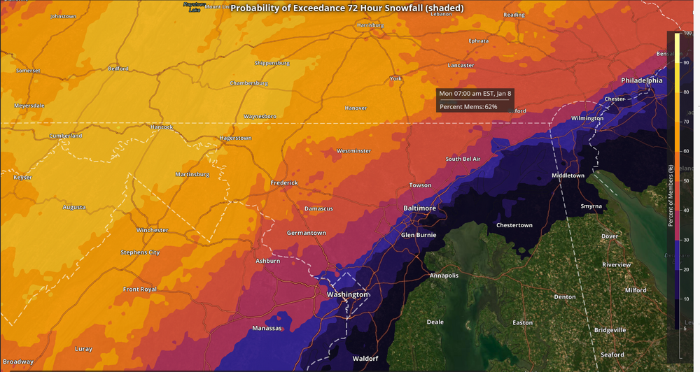
>= 5"
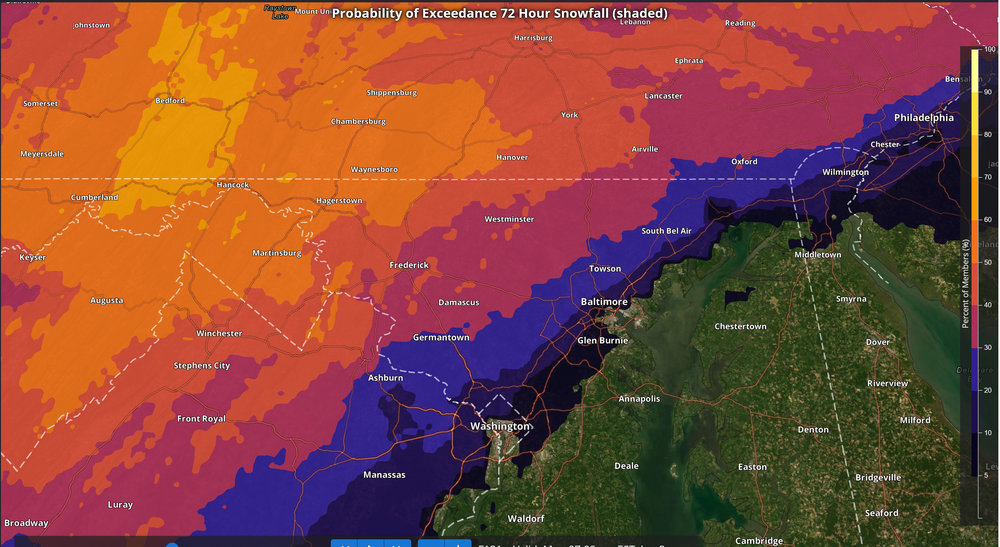
Not bad considering the time before the actual storm
-
4
-
-
3 minutes ago, kristia said:
I am up by Gambrill Park. Moved here from Baltimore County in 2020. Night and day compared to lower elevations.
Your area is gorgeous. I was on a hike in those parts last month. Should be a nice little storm up there!
-
3 minutes ago, psuhoffman said:
1z updated on wxbell. Another slow decline unfortunately. Not sure what caused it. 18z data was slightly better I thought then 12z. But it is what it is. Still would be a decent way to get on the board for many.

Looks like a slight tick down and actually the biggest loss north of the Mason Dixon where 1-2" was lost over the highlands. We'll see this bounce a little bit in the coming days, but this is still a decent event to get the ball rolling. Yes, it stinks not getting a bomb, but having snowfall during the day and evening on Saturday will bring up everyone's spirit. I'm staying positive because this will be my first good event since moving back home. It'll be special to me
-
12
-
-
1 minute ago, Eskimo Joe said:
Spot on as usual. You can also see the Monocacy Valley snow hole illustrated. It seems to rear it's ugly head when there isn't sustained cold air draining into Frederick City. I know that's been the perennial bane of @catoctin wx and @Mrs.J
Life in the valley! I live on a hill off Monocacy, but I still won't get as much as places along the Catoctins to the west of Thurmont. Still a nice event out in these parts.
Just now, mappy said:01z is coming in now. Better further north, about the same near DC. Map soon.
Thanks! I was gonna start looking myself, so I appreciate the aid on posting the maps

-
1
-
-
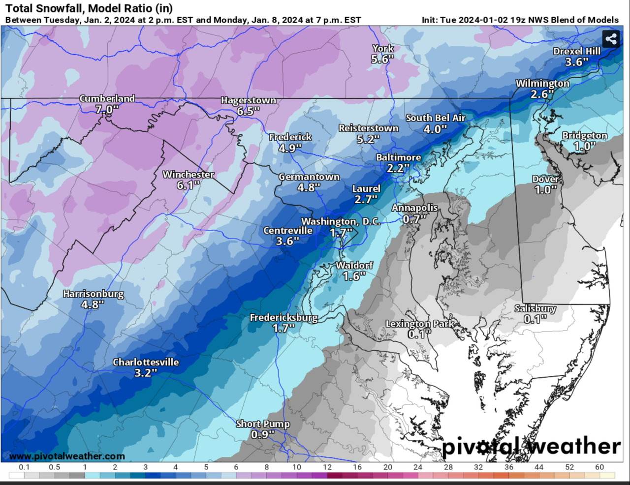
3 minutes ago, mappy said:
FWIW, 19z NWS Blend of Models (aka the NBM that has been mentioned) snow map. It is a step back from 13z that had DC getting 2”, and my backyard in the 8-9” range

This was definitely expected with the latest data at 12z, but definitely not the end of the world. It's a solid first event, verbatim. One of the characteristics I like about the NBM is being able to depict elevation and outlining the areas of focus climo wise. We haven't even gotten into hi-res territory yet where there will be more definition inside 48 hrs and even more inside 24 hrs. A textbook fall line scenario right there. 3-6" with local to 8" is a good call for areas NW of the fall line with 1-3" max to 4" along and southeast. I'd take this in a heartbeat. Thanks for that update @mappy
-
9
-
-
31 minutes ago, WVclimo said:
Are today’s CIPS analogs still showing Jan 1996, Feb 2010, Feb 1983 and Jan 2016 for Saturday ?
")
If they did, I would have to stop using them and then I would be sad

Fortunately no!
-
3
-


Jan Medium/Long Range Disco 2: Total Obliteration is Coming
in Mid Atlantic
Posted
I’m off all next week. Wanna meet up and chase? I’ll bring the food, you bring the beer")