

MillvilleWx
-
Posts
4,422 -
Joined
-
Last visited
Content Type
Profiles
Blogs
Forums
American Weather
Media Demo
Store
Gallery
Posts posted by MillvilleWx
-
-
20° at the top of the hill and 10° 1 mile away in a valley. Incredible
-
 2
2
-
-
You guys are putting way too much time into a NS dominant system. Do yourself a favor and prepare for nothing and hope for more than that. I don’t waste my time with those evolutions in the Mid Atlantic. We aren’t New England.
-
9
-
-
7 minutes ago, DDweatherman said:
Predictions for the euro, a nice swath of 2-4 from N edge of DC (say about Georgetown) to the M/D line. About .2-.25" QPF for most.
I imagine it holds or shifts the slightest bit north. It’s been consistent recently, which is great for my hood being consistently over 3”. Good dynamics should help with this one so long as the jet doesn’t cross north of us.
-
2
-
 4
4
-
-
Pretty neat microclimate in my part of Frederick. Low was only 17° this morning but the neighborhood across the way of Monocacy in a “bowl” got down to 12°. More decoupling occurring naturally at lower elevation.
Fast forward to now and that same station is 3° warmer than my place (26 vs 23) so the elevation is again playing a role. It helps with snow as well being at over 310ft while places around me are 60-80 ft lower. Pretty cool
-
1
-
-
I have nothing to add right now that hasn’t already been said. I hate NS dominated systems, but this one has more potential than our usual nothing-burgers.
General 1-3” with up to 4” in the hills and areas along and west of US15. ECMWF has been fairly firm on its depiction last succession of runs. QPF between 0.15-0.35 will be common with better lift through the aid of a strong mid-upper speed max cutting underneath. Should be in the left exit region of the jet for a period of time on Friday to generate good lift and nice dendrites before everything pushes out.
Those looking for a bigger hit (6+”) should probably look elsewhere. This is missing some components for a bigger storm. The main component decided to rush out ahead of the primary vort which will negate full phasing or even more substantial interactions. Unless that slows down and the NS can catch it with short term trends, bar should be 5” or less everywhere.
-
13
-
3
-
-
4 hours ago, pasnownut said:
I posted a few snippets about nooners and what is showing. Whatchu thinkin for the Friday deal?
Looks like we get some phasing of NS, but not really a big trifecta of sorts. Trough rather progressive so once again, while a good event, upside to me would be coastal slowing down and hangin back a bit, but not really sure how much further amplification there could be. RGEM was nicest to look at, ICON wasnt too shabby, and GFS a little strung out but workable. I'd think a 3-6 kinda deal isnt far fetched??
Busy day! Just getting around to seeing this my man.
Haven’t looked too closely at Friday, so I’ll reserve any comment until I get a better look at guidance. It does look like a close call for a moderate event in the LSV and around the Mason Dixon. Best opportunity is currently north. I’ll try to chime in tonight with more when I get a better handle. Today was a lot of running around and taking care of stuff, plus snow cleanup. Man, it actually was nice to be cleaning snow!!

-
4
-
-
Glad to see everyone cashed in on the storm. Looks like 3-5” was very common. Let’s smack another on Friday!
-
7
-
-
11 minutes ago, WxUSAF said:
Unusually even 4-5.5” snow for most of the NoVA/DC/central MD corridor per spotter reports.
This was such a great storm for everyone. The lower density snow fall to coat everything. The rates were even solid for everyone at points. Everyone scored. Hell, we even got a flash flood event in Georgetown!
-
1
-
 9
9
-
-
1 hour ago, jayyy said:
4.75” final total. The banding from 7-11pm was the money maker up this way.I slept more this morning and missed the additional snow so I’ll keep my total at 4.7” for the call. That period from 7-Midnight was the sweet spot. I agree. It was dumping for 2 hrs between 945-1145 that really piled up the accums. Had another wave between 1230 and when I took another measurement when it felt like a snow globe. Was in my element

-
5
-
-
10 minutes ago, Mrs.J said:
25 out. Did 3 measurements and got a solid 4.25". There is some light precip that looks to not be freezing rain or drizzle. Looks like pixie dust falling. Just cleared off the drive and that went fast as it was a dry snow.
Sounds about in line with my total. We had a few bands affect the north side of town last night that probably boosted us a bit compared to BC. Great storm for our hoods!
-
1
-
-
3 minutes ago, Bob Chill said:
Me thinks it gon b a lottle crunchy tomorrow morning.
In MD, if you do it properly, every morning can be crunchy

-
2
-
-
4.7” with some compaction likely after I went to bed. A beautiful scene out there. Great storm
-
7
-
-
2 minutes ago, Deck Pic said:
I'm getting the goods again. Interesting storm. LWX did well with the upgrade.
This was a solid storm overall. Best part was the thermals being fairly friendly for mostly everyone. Many got the 3-5” forecast with some likely near 6” in NoVA and will be approaching in northern MD. I give it an A for the performance.
-
7
-
-
2 minutes ago, Maestrobjwa said:
Ah!!! Just stepped outside to take out the garbage. Still have a nice band coming down...
my attempted measurement: Almost exactly 4 inches.
Now I only just stepped outside, so with compaction it could be a bit more!
Great to hear! It’s been a great storm for the metros. Very much needed. Let’s get you guys to 5!
-
2
-
-
4 hours ago, mappy said:
Sick in bed and loving all the snow pics.
Feel better Katie!!
-
1
-
-
Man. That band near Odenton is a beast. Any reports from there?
-
1
-
-
10 hours ago, MillvilleWx said:
Hey guys. Looks like a nice high end advisory type event for part of the subforum. There’s a shot for low end warning criteria if the dynamics at play set up just right. 3-5” with as much as 7” max for almost everyone here. Enjoy!
Hey y’all! Just a heads up. Forecast seems on track, although will need to watch the eastern side of the sub with the coastal enhancement. That could yield a decent suprise tomorrow if it breaks correctly. This has been an over performer for many, so it wouldn’t shock me. I like the WSW in place for York/Lancaster as those areas of the best place for a positive bust given the expected 85H frontogen placement and deeper column saturation to correlate with better dendrite formations and efficient snowfall. I’m pulling for everyone to get a nice piece of the pie and enhance the wintry scene expected this week.
Check back later today for those pics and totals
")
-
4
-
1
-
-
1:15 AM EST report:
4.3” in 5N Frederick
Light to occasionally moderate snow continues. High ratio fluff for sure. Vis around 0.5-0.75 SM. We should make it to 5” here and could make a run at 6” if we get into a good band or two. The little storm that could!
-
2
-
-
12 minutes ago, ravensrule said:
Did you know JFK got shot?.
I almost spilled my drink
-
3
-
-
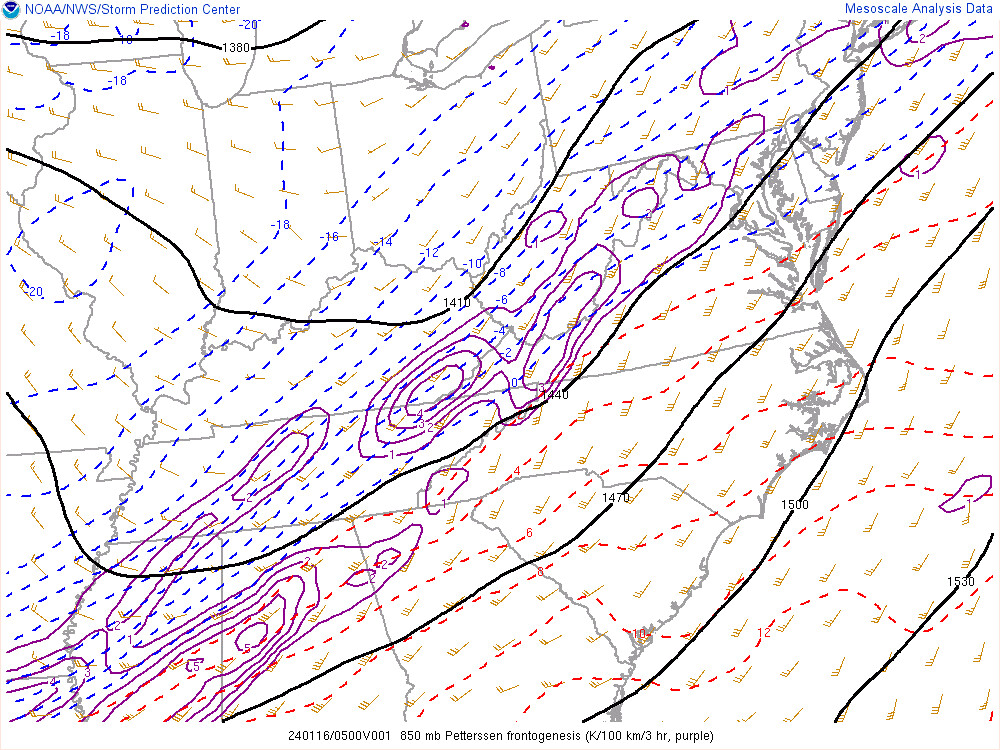
17 minutes ago, Wxtrix said:
more frontogensis maps and fewer clown maps! lol!
YES!!!
-
5
-
-
4 minutes ago, Wxtrix said:
i love frontogenesis.
Same! One of my absolute favorite dynamical meteorology components. Can tell a good part of the story of an event when coupled with a few other factors.
4 minutes ago, HighStakes said:Looks like a solid 4 here.
Awesome! Should push 6-8” I imagine up at your lat and elevation. If the coastal gets going, you could definitely push 8” imo. Let’s hope!
-
5
-
-
7 minutes ago, Wxtrix said:
i guess i'm staying up for a bit.
Yeah. Banding is establishing itself fairly nicely again. We’re pushing over 4” now. Will take an official ob at 1am.
-
7
-
-
Steady light to moderate snow in north Frederick. Small flakes, but a good amount of them slowly adding to totals. Will take another measurement in a hour or two.
-
4
-
-
1 minute ago, stormtracker said:
You better not

Seriously. This is such a great forum. We have our moments, but the general knowledge and comedic value is just too damn good. So glad I found this place way back in 2011-12.
Also, I’m off all this week and next weekend. We need to plan a meet up. I could go for some drinks and grub down in the district.

-
8
-
Jan 19th Snow on Snow: the this always works until it doesn't thread
in Mid Atlantic
Posted
Thought this would be a good time to make a rudimentary snow map for ole times sake. Apologies for the crude map design. Doing this on my phone, but still works good enough. Each area is a zone with a first call forecast. Might have a few edits later, but this could very well be my only call.
Forecast
Zone A: Nothing-1” (Trace begins north of Potomac latitude); Up to 2” possible if everything breaks right
Zone B: 1-2” w/ max to 3” if everything breaks right
Zone C: 2-4” (Highest across Parrs Ridge; elevations >600’)
Zone D: 2.5-5” w/ local max of 6” (Highest along the M/D Line and elevations >850’. Lowest in elevations <275’ in valleys)
Zone E: 5-10”
Catoctins: 4-6” w/ max to 7”