

MillvilleWx
-
Posts
4,422 -
Joined
-
Last visited
Content Type
Profiles
Blogs
Forums
American Weather
Media Demo
Store
Gallery
Posts posted by MillvilleWx
-
-
2 minutes ago, MillvilleWx said:
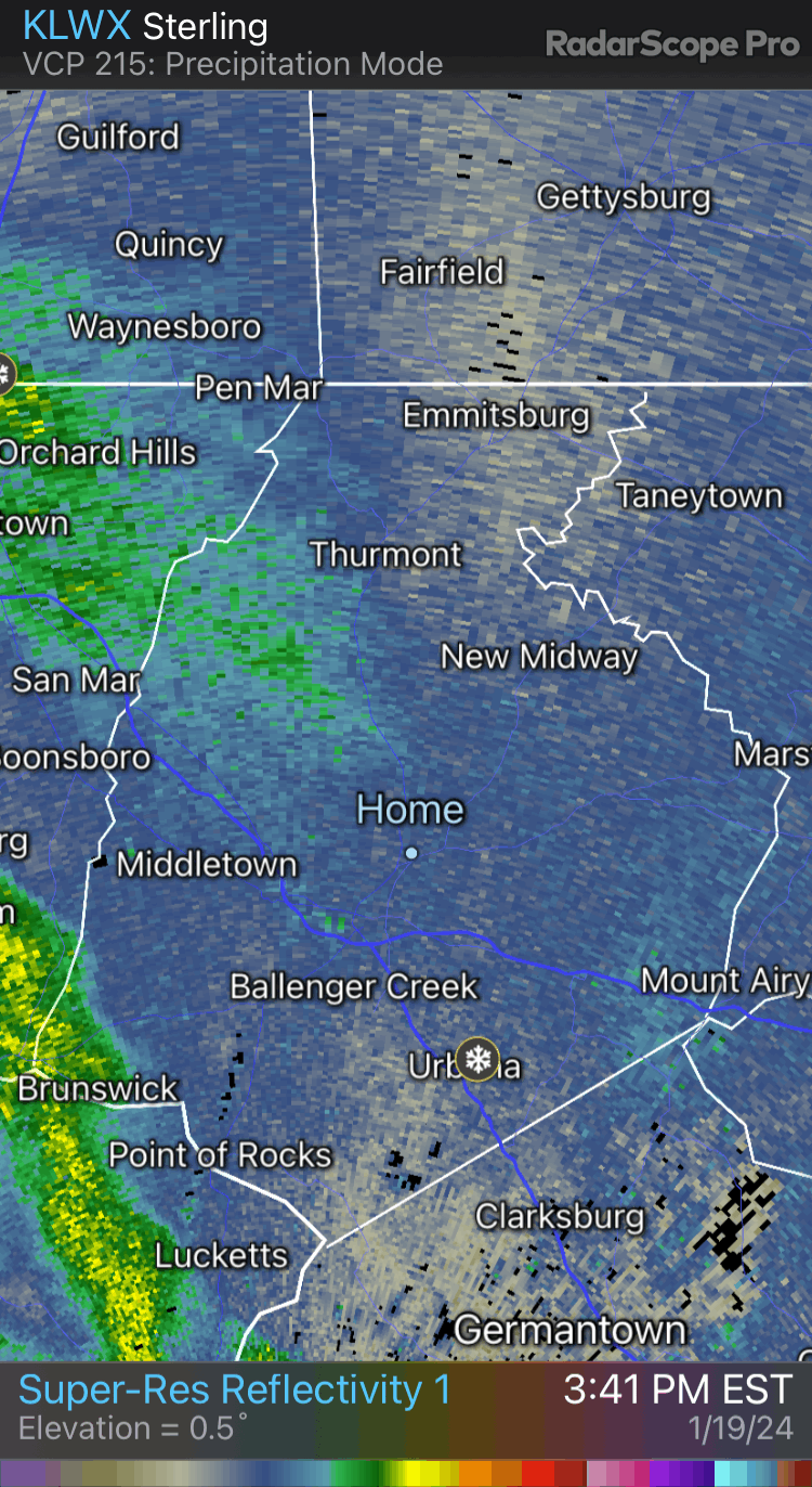
Our place got hit flush with the entire streamer. Place completely caved and all the work to clear the snow for our complex ended in coverage. It was a nice way to end a beautiful winter day.

Flush!
-
 13
13
-
 1
1
-
-
29 minutes ago, 87storms said:
This has been a flush hit. Still going here with large flakes.21 minutes ago, kristia said:It has been! It’s weird not being able to go anywhere. I forgot what that feels like. Not that I have anywhere to be but I just would like the option to be available

Our place got hit flush with the entire streamer. Place completely caved and all the work to clear the snow for our complex ended in coverage. It was a nice way to end a beautiful winter day.
-
9
-
-
3” measured at my place and continuous light snow. Refreshed everything, but definitely not the 5-8” they upgraded us to for some reason. I mentioned last night that I was concerned for the county with the best returns aimed for MoCo to HoCo which I’m happy materialized!
I’m glad everyone in here got some snow and some really cashed on this event. Loving all the pics. Keep them coming
")
-
3
-
 1
1
-
-
Enjoy you guys! Woke up to about 1.5” of new snow. This is definitely going to fall short in Frederick compared to the last event. Snow on snow is awesome though. Looks beautiful out. Bring home the goods today!
-
2
-
-
Hmmmm. Getting a little concerned about the valley here in Frederick. Might see the heaviest snow go south and east of here. We shall see later. Still looks like 2-4” is possible for me, but heavier totals might just miss here. Hopefully it plays out like the NAM, but I never want to put faith in that model when other hi-res are starting to get that look I’m mentioning.
-
2 minutes ago, Terpeast said:
Also, LWX mentioned possible CSI. I've seen that before and that kind of snow can pile up in a real hurry
This. Before (Few days back) it was looking like that was favored for areas well to our north so I was content with the scraps. Now the trend is very much for this to happen overhead and the soundings/spatial outputs for 7H VV’s and correlated QG-convergence panels indicates that’s the expectation. We will see rates in some bands surpass what just occurred from the past event. It’s a vigorous jet streak we are working with. If you know anything about synoptic scale meteorology and translating to the mesoscale, this is prime for some surprises, so long as we aren’t being lead astray by guidance.
-
10
-
1
-
-
7 minutes ago, Eskimo Joe said:
It’s going to be snow globing if these depictions are right. Amazing
-
3
-
1
-
-
14 minutes ago, DarkSharkWX said:
 woah
woah
Holy crap. It got a clue!!! Never thought I’d see that. Good stuff
-
 1
1
-
-
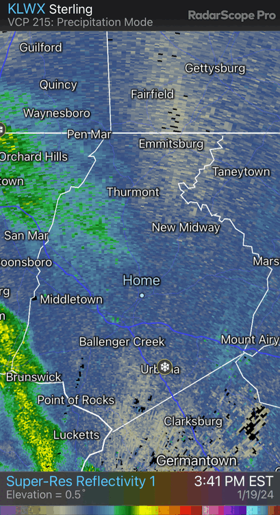
42 minutes ago, clskinsfan said:
RAP still dropping bombs. It is still snowing here:

The RAP is consistent with a band of heavy snow from the northern neck and adjacent WV panhandle up through Frederick into northern Carroll. Like, super consistent and the ECMWF had it for many runs in a row at one point as well. Might have something here! Makes sense when you look at the 7H VV panels. It is textbook for that corridor. Let’s get it!!
-
7
-
1
-
-
2 minutes ago, North Balti Zen said:
Good lord - I just had to clear off my snowboard and the other spots I measure as a control so I could potentially measure new snow. It has been a LONG time since that was a consideration…
Just now, wxdude64 said:Just did the same about 15 minutes ago!
We’re a snow town again!
-
4
-
3
-
-
30/19 5N Frederick
A crisp winter night awaiting a winter wonderland by the morning. Picking up some friends of ours at the airport in 2.5 hrs. I’ll be up very late tonight. Company is staying so they can catch an evening flight tomorrow to Iceland. Need to prep for the time change. Both meteorologists too. We are going to stay up and when it snows, go for a Sheetz run.
What an awesome week I planned for this staycation. I hope my work is handling things okay. It’ll be nice to go back fully recharged and ready to roll. Let’s rock
-
13
-
2
-
-
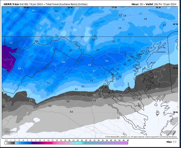
33 minutes ago, clskinsfan said:
HRRR getting juicier with every run.

Good to see. It’ll be fully caught up by 00z Saturday
-
4
-
-
1 hour ago, Eskimo Joe said:
Either you, @MillvilleWx, or @wxmvpete
Ain’t no way I’m putting my luck out there lol. Whoever started the last one should do honors. Play the hot hand
-
Just now, mappy said:
my head exploded a decade plus ago when i saw them for the first time. i give the man credit, to create maps that consistently awful to interpret is rather impressive.
It’s an art. Even I’m impressed at the consistency all these years
-
4
-
-
6 minutes ago, stormtracker said:
I hope the Grindr Forecast System is probably gonna hold. It never gets this excited. Blend the snowiest model with the other snowiest model and go from there.
-
6
-
-
47 minutes ago, AlexD1990 said:
@MillvilleWx didn't want to clutter main thread with a IMBY question, but what are your thoughts on some coastal/norlun enhancement on this side of the bay? I feel like some of the increase shown on modeling over this way may be due to that.
No problem! It’s definitely possible, but narrowing exactly where that band could setup is tough and a nowcast situation. I think it’s plausible somewhere between south-central Jersey coast down to about OCMD extending to the western shore of the Bay. A lot of area and still a question mark. If I HAD to pick a spot, I like northern DE through northern MD along the M/D as the primary spot for something like that just based on trends and positioning of the upper jet. Will be watching intently along with the NWS because that’s the kind of stuff that can trigger a Hazard upgrade (WWA -> WSW).
-
3
-
-
30 minutes ago, yoda said:
URGENT - WINTER WEATHER MESSAGE
National Weather Service Baltimore MD/Washington DC
227 PM EST Thu Jan 18 2024

MDZ004>006-008-011-507-508-190330-
/O.CON.KLWX.WW.Y.0009.240119T0900Z-240120T0600Z/
Frederick MD-Carroll-Northern Baltimore-Cecil-Southern Baltimore-
Northwest Harford-Southeast Harford-
227 PM EST Thu Jan 18 2024

...WINTER WEATHER ADVISORY REMAINS IN EFFECT FROM 4 AM FRIDAY TO
1 AM EST SATURDAY...

* WHAT...Snow expected. Total snow accumulations of 2 to 4 with
  localized amounts around 5 inches.

* WHERE...Portions of north central, northeast and northern
  Maryland.

* WHEN...From 4 AM Friday to 1 AM EST Saturday.

* IMPACTS...Plan on slippery road conditions. The hazardous
  conditions will impact the Friday morning and evening commute.
Man. It’s like I should work for the National Weather Service

-
3
-
15
-
-
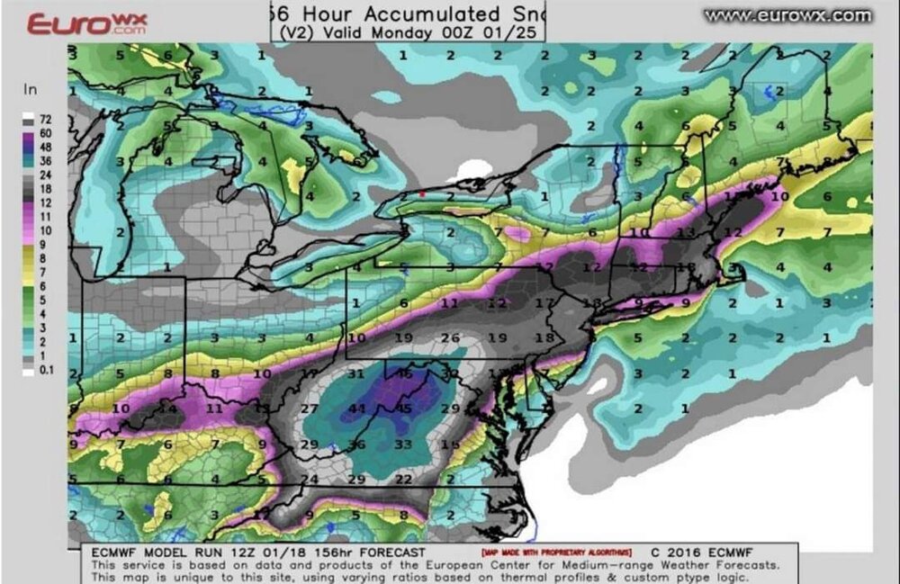
Just now, jgentworth said:
18z HRRR seems to be drier than the 12z NAM by a bit. But we're talking 15-20hrs on the HRRR which I think is probably out of its range a bit.
The HRRR couldn’t even get the storm right while it was happening earlier this week. I would ignore it until it gets a clue. Other hi-res and ECMWF are your best bets at the moment.
-
10
-
4
-
-
One things for sure in this setup; it will start out cold and end cold. 20s for many for much of, if not the whole event. Wet bulb between 23-27 from north to south. 7H VV signals show decent ascent aligned with the LER of a prominent jet streak. There will be a 4-6 hr period of good snow rates that should accumulate efficiently. This is a textbook WWA event for everyone. WSW possible across areas north of I-70, but not impossible. Likely less than 20%, but that’s better than 0%.
Heaviest snow should be within Frederick/Carroll/northern Baltimore Co/northern Harford, but don’t count out VA northern neck and WV Panhandle either. M/D line is favored right now, but as Bob mentioned earlier, someone will sneak a mini-jack outside the northern tier if the banding materializes.
-
20
-
2
-
-
27 minutes ago, WVsnowlover said:
From my Facebook memory from 8 years ago today

And to think it was wildly underdone for many on that map. A truly epic storm
-
3
-
-
1 minute ago, HighStakes said:
I'm staring to really like tomorrow. Models are converging on the highest totals in northern MD. Hopefully there's not a last minute shift. To expand on your post about ratios, I agree. I expect mostly 15:1 up here. We always do well with ratios even in more marginal storms. The Euro which always is warmer than GFS has Westminster at 27 at 18z with 850's at -8. I think 20:1 is not out of the questions especially if we still have some banding the last several hours of the storm. Trying not to be to weenieish!! Lol.
Definitely agree. It’s just the historical trend that has occurred for you guys up that way. A little orographic assistance helps locally with ascent and ratios. Should be a winter wonderland in your area by tomorrow afternoon. Loving the trends this morning. This vort is pretty decent, so as long as it isn’t too far north, there’s some solid 7H VV’s and strong LER dynamics to work with. Probably see some scattered banding structures out of this one.
-
4
-
-
11 minutes ago, MillvilleWx said:
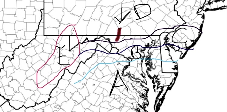
Thought this would be a good time to make a rudimentary snow map for ole times sake. Apologies for the crude map design. Doing this on my phone, but still works good enough. Each area is a zone with a first call forecast. Might have a few edits later, but this could very well be my only call.
Forecast
Zone A: Nothing-1” (Trace begins north of Potomac latitude); Up to 2” possible if everything breaks right
Zone B: 1-2” w/ max to 3” if everything breaks right
Zone C: 2-4” (Highest across Parrs Ridge; elevations >600’)
Zone D: 2.5-5” w/ local max of 6” (Highest along the M/D Line and elevations >850’. Lowest in elevations <275’ in valleys)
Zone E: 5-10”
Catoctins: 4-6” w/ max to 7”
Hey guys. Thought I’d stop by and provide my forecast for the coming event. Looks like PA is solidly in my Zone D with a small piece in the Catoctins. Liking 3-5” for much of the subforum. Min of 2” and max of 7” in the highest elevations if everything broke right. Think 3-5” is a good call for the time being. Let’s freshen up this snow!

-
6
-
3
-
-
1 minute ago, wxmvpete said:
Living on the edge of your Zone C and Zone D. I'd happily take another 3" as would my kids!
I like 3-5” for your hood at your elevation. I think people like you, @HighStakes @psuhoffman up there towards the M/D should do pretty well with this one! Be sure to add a max right over your house if you’re doing the Winter Desk
-
1
-
-
3 minutes ago, high risk said:
I don't think that this is a storm for which the super generous Kuchera ratios will work well. It's not super cold, and lift does not appear to be maximized in the DGZ. With cold ground and temps a few degrees below freezing, this might be one of those cases in which the 10:1 maps actually work pretty well.
I think the average will be right around that 10-12:1, but I wouldn’t be surprised if the Parrs Ridge crew above 800’ and the Catoctins get closer to 14-15:1 overall. They seem to pull that in these types of setups. Not a crazy storm and one where the max is limited in potential, but snow on snow is always welcomed.
-
5
-

Jan 19th Storm OBS Thread
in Mid Atlantic
Posted
Not quite, but over 0.5” in quick time. It was the best rates and dendrites I saw today. A beautiful smack to round out another wintry day. Up over 8” for the season now