

MillvilleWx
-
Posts
4,422 -
Joined
-
Last visited
Content Type
Profiles
Blogs
Forums
American Weather
Media Demo
Store
Gallery
Posts posted by MillvilleWx
-
-
Snow coming to an end here in 5N Frederick
2.3” is the total. Not bad for lower elevation. It dumped for hours this morning. Very scenic
-
 5
5
-
-
23 minutes ago, Imgoinhungry said:
Location? Annoying it doesnt show up on tapatalk
.5N Frederick
-
1
-
-
Officially flipped to snow at 5:07am. Massive flakes
-
6
-
-
This is very impressive. Sleet mixing in now with the rain. Only a matter of time.
-
2
-
-
10 minutes ago, DDweatherman said:
I’m in the mountain cut in right at Liberty with the changeover happening about 30 mins ago. Immediately went to SN+
Yeah. You aren’t too far from me to the north. You should do fairly well with this one. Enjoy the nukage
")
-
3
-
-
HRRR is a touch slow with the R/S line advancement, but it’s not too far off. Maybe 30 min. Snowing near Waynesboro now according to mPing. The bright banding on radar is wild.
-
1
-
-
3 minutes ago, DDweatherman said:
It’s a scene here already with these mashed potatoes falling.
Whenever it flips, there will be steady rippage for 2-4 hrs before it slowly lets up. Precip rates are around 0.15-0.25”/hr at this point according to the local weather station right across the street. That’s plenty for 1-2”/hr snowfall rate. Will lose a little in the beginning to cool the surface, but once it’s established, off to the races.
-
1
-
-
Snowing in the Catoctins just to my north. Temp and dew point are plummeting in my hood as we speak. Probably a hour or so before it flips and rips.
Seeing snow reports on mPing across the PA line. HRRR doing a solid job with the R/S line advancement.
-
4
-
 1
1
-
-
25 minutes ago, notvirga! said:
is this similar to what you are thinking?
https://x.com/matthewcappucci/status/1757165780666290588?s=46It’s close. He’s not highlighting the elevation areas within the 1-3” shading, so it’s a broadbrush. Could be right, but I hate maps that don’t provide the detail along the ridge areas that ride along MD27 and along the M/D. For a quick map, it’s not bad.
-
2
-
-
I really do think there is going to be an elevation marker that will make or break snow totals in this one. My gut is around 500ft +/- 50ft. It’s going to be that tight.
I do like the northern crew on a line from the Catoctins across north-central Carroll and Baltimore Counties, then the northern tier of Harford and Cecil towards the PA line.
Areas that have the best chance to do well are; Thurmont, Sabiasville, Taneytown, Emmitsburg, Manchester, Hampstead, Parkton, Jarrettsville, Norrisville, areas north of Rt 1 in Cecil, the entire southern tier of PA along the M/D. Additional areas that could cash decently include WV Panhandle, Mount Airy, Damascus, and terrain in Western HoCo. Any of these areas will have a shot at 2+” of snow imo with the best opportunity for high end advisory.
Outside that is probably a 1-3” deal at best with the cutoff at 250ft elevation and south of I-66.
This is my initial forecast just gleaning over everything and taking climo and BL temps into consideration.
-
6
-
3
-
-
1 hour ago, Eskimo Joe said:
Advisories for the NW crew.
Definitely the right call. Elevation areas north of I-70 I would be pretty excited.
-
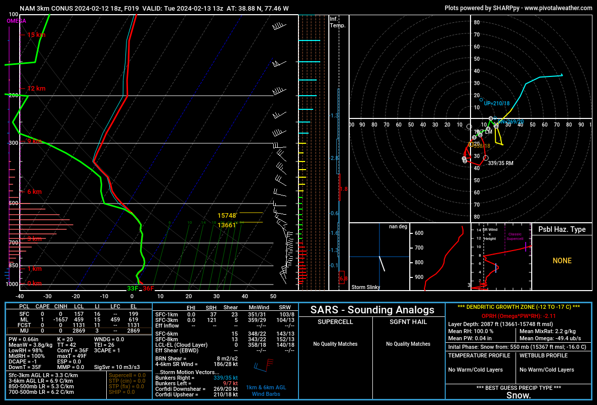
1 hour ago, Terpeast said:
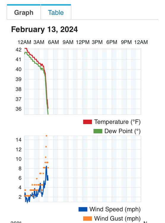
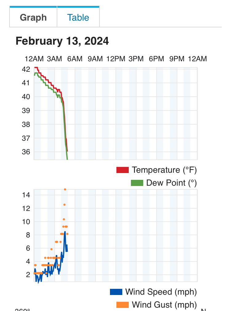
18z 3k NAM IAD sounding right when it flips
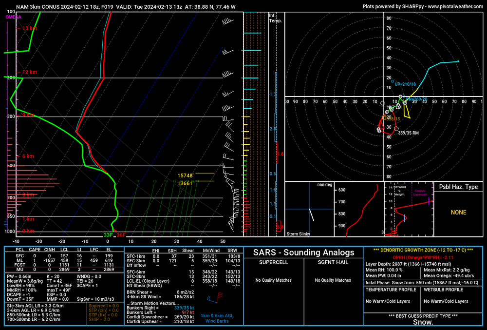
I haven’t seen a sounding like this since Jan 2011. I’m not even kidding. Good lord
-
7
-
-
RAP/HRRR bias at this range is too heavy with precip and will adjust. However, this is a fairly dynamic event, so it might not be THAT far off. This is a tightrope forecast. There will be winners and losers within close proxy of each other. The higher your elevation, the better. Especially if you have latitude.
-
4
-
 1
1
-
-
15 minutes ago, snowmagnet said:
Is it possible to continue to trend south?? Fairfax county hopeful here…I want Yoda to pay $200
I think flakes will fly, but not really amount to much. I think the max is 1-2” if literally everything broke right. This is more for MD and points and north
-
1
-
-
5 minutes ago, WeatherQ said:
Ok MillvilleWx .. I need your no BS assessment … we have 2 globals and multiple regionals now with the NEMD crushed signal .. The RAP shows a perfect SLP pass off ORF … what’s the red tagger thought?
My thought is to prepare for potential snowstorm across Cecil county and points northeast. It’ll be a heavy wet snow and accumulate on elevated surfaces first. It could be tricky travel tomorrow morning and afternoon. The trend is undeniable at this point. Utilize mesos now and ensemble based products
-
4
-
1
-
-
2 minutes ago, clskinsfan said:
Latest HRRR would be a shellacking out this way.

That would be some serious mashed potatoes if that verified. Huge flakes
-
2
-
1
-
-
Someone is going to get hit pretty solidly tomorrow morning. My guess is elevation areas above 500’ will be the primary with NE MD in a good spot given the expected track of the 7H/85H lows on mesos.
I feel FDK will get snow and it could be heavy for a short time, but too warm initially to be part of the major accumulations. Parrs Ridge down through MoCo could snag some accums as well, but I still like I-70 north with elevation to be the winners.
This is a tricky storm for guidance due to the convective initiation and spatial resolve across the south. I’ve been peeking at this potential all week and figured we’d have a surprise in store somewhere. Didn’t think we’d be in the game, if I’m being completely honest. I thought NYC could luck into it. Maybe some of us can as well. Will be interesting to track. If only we were 2-3° colder leading in…
-
7
-
2
-
 1
1
-
-
54 minutes ago, CAPE said:
Still 2 weeks out but this might be the one. Impressive signal at this range.

I really like the period from the last full week of Feb through mid-March. We’ve scored in that time frame before. I think expectations for the lowlands should be tempered (I know you know lol), but the climo favored areas with elevation and/or latitude should be keen on watching what’s coming down the pike.
-
7
-
-
I’m still not sold on this event for anyone south of I-70 and realistically any appreciable snow south of the M/D. Sure we can luck into something, but I like the PA Turnpike and points north for this one right now. I think WSW will be relegated to north of the subforum. This is not a setup that favors us in a climo sense. If we had anything resembling cold air in here prior, we’d be game on, but man…if only
-
3
-
-
I’ll be following for the VDay event, but we need the stars to align. Not out of the realm of possibility for sure, but thermals will be a problem. Just no significant cold air to work with.
The pattern afterwards though

-
11
-
-
3 hours ago, CAPE said:
lol Harbaugh

-
2
-
-
I feel the Northeast/Mid Atlantic from central VA up to Boston gets one solid snowstorm, but the question is who gets the best. ENSO signals the Mid Atlantic, and the pattern may be favorable into March. Some of the best storms are in mid-late Feb and March all-time, so I wouldn't be discounting a late season shelling. I just want to see it snow. Staying power is the least of my worries at this point. Feb 2006 was a shelling with drippage by 10am and I still love the hell out of that system. I like watching it snow and rack up, but staying power later in the season is the least of my wants.
-
11
-
-
Burnes trade was a great addition. Looking at the peripherals, in his "off" year, Corbin still put up a solid 3.32 ERA and his H/9 was equal to his Cy Young year a few years ago at 6.6 H/9. His biggest outlier was the BB/9 which jumped from 1.8 -> 2.3 -> 3.1 from 2021 (CY) to 2023. That's a stark rise and I think some of it has to do with usage early in career and resorting back to his mechanics of old prior to 2021. I think the coaches can right the ship and get him back to where he needs to be. He decreases the walks, he'll be a major player for us in competing for the next few years, minimum.
-
3
-
-
1 hour ago, Scarlet Pimpernel said:
LOL! Well, I actually used to have the handle of "Always in Zugzwang". For what it's worth!
You know. I was wondering if that was you, Mike! Haha
-
 1
1
-
Mid-Atlantic Snow Totals Thread - Winter 2023-2024
in Mid Atlantic
Posted
2/13 - 2.3”
Total* - 11.5”
*Missed a snow event in January. No reading so likely closer to 12-12.5”