

MillvilleWx
-
Posts
4,423 -
Joined
-
Last visited
Content Type
Profiles
Blogs
Forums
American Weather
Media Demo
Store
Gallery
Posts posted by MillvilleWx
-
-
0.1-0.2” from round 1
This was definitely a win for models not named the HRRR that was bone dry across the other side of the Potomac. Very light snow falling now in 5N Frederick. Expecting 2-4” with max of 5-5.5” here.
-
 7
7
-
-
3 hours ago, Paleocene said:
Is that map based on population density? Or road density?
There’s a lot of variables involved, but population is taken into consideration. Only one piece of the puzzle
-
 1
1
-
-
19 minutes ago, Terpeast said:
Nice runs so far. I think the 12k is overdone, 3k more realistic. But growing more confident for an area wide 2-4"er with someone getting 5"+
Agreed with this. I have a max of 6” somewhere in this one, but the concept is the same. A nice storm for much, if not everyone here.
-
10
-
-
52 minutes ago, psuhoffman said:
@Terpeast @WxUSAF @MillvilleWxI’ve noticed the last 24 hours the runs that are more suppressive with the TPV get the NS track we need but the wave ends up more suppressed with almost no STJ interaction. The less suppressive runs have a bigger storm but the NS wave comes across further north and so it’s mostly a Philly northeast storm.
So what’s the path for us? What do we root for? My gut says more suppressive flow combined with stronger SW. But those runs seem to have less STJ and so it’s not much better.
I have not paid much attention to this setup because I’ve been focused with the short term threat, so I will differ to the others. @CAPE has a great breakdown and I agree on his analysis. This setup is the precursor to the next one, so we have a bit of a ways to go. By Tuesday, we’ll have a better handle.
-
5
-
-
51 minutes ago, DarkSharkWX said:
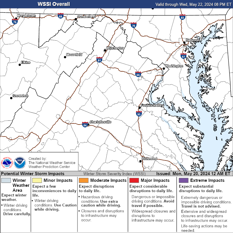
I know it’s just a tiny little artifact in it all, but the WSSI has a tiny dot just north of FDK and that is basically where I live. I’ve never seen anything like that before. Hilarious
-
3
-
-
Just now, NorthArlington101 said:
I tried to use it for our last event and it crapped out before we got 24 hours in, but it showed a lot of sleet and I got a lot of rain, so it's not a magic bullet. I do think it is "supposed" to be the latest and greatest short/hi-res model, though.
It’s not. It has a lot of work to do imo.
-
2
-
1
-
-
4 minutes ago, Its a Breeze said:
...or not. Thought I remembered this:
https://www.weather.gov/hazardsimplification/revampprogress
Looks like next year they're changing again. Removing "advisory" completely.
Ahhh. Thanks! I must’ve missed that part, so I appreciate the info. Being at the National Center, I’m semi out of the loop on the HazSimp process since we don’t issue anything at WPC. Feel bad I didn’t know that.
-
2 minutes ago, Terpeast said:
I don’t know what they‘re seeing to go that bullish. I keep seeing 1-3/2-4
I’m looking at 2-4” with jack of 5-6” in the best banding and over the ridge areas. I’ll be curious to read their disco
-
3
-
1
-
-
Wow. Sterling going guns blazing. That is wild. Things you love to see…it
-
5
-
-
Just now, Terpeast said:

-
3
-
 1
1
-
-
5 minutes ago, jayyy said:
Was just going to say the same thing. My doctor thinks herbal remedies are better for my health, and I concur.
.Sent you a PM
-
1
-
-
Just now, stormtracker said:
Y’all are fucking alcoholics. My kinda crew.
Now that I’m back east, I need to come have brunch with you guys at some point and stumble out of it.
-
6
-
-
4 minutes ago, Eskimo Joe said:
They need to keep the Winter Weather Advisory.
We definitely will. I don’t see these four ever changing. It was a good compromise of the simplification process.
-
3
-
-
46 minutes ago, Its a Breeze said:
Perfect event for a 'Snow Advisory'
Why on Earth did they get rid of those?
NWS went to hazard simplification due to social sciences showing that public interpretation was confused with the various different products. WWA/WSW/Blizzard Warning will be the primary hazards now with an Ice Storm Warning for primary high impact freezing rain only events. This has received a positive reception so far, so don’t expect anything from the past to return.
-
4
-
7
-
 1
1
-
-
42 minutes ago, Mrs.J said:
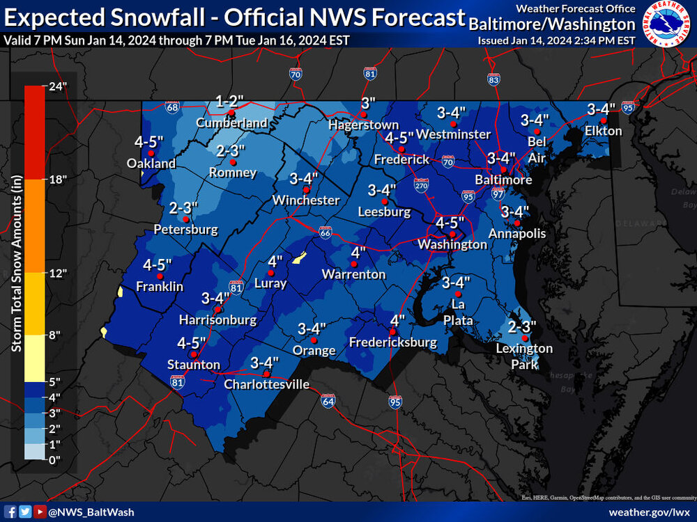
Snow up here in Frederick now. Big fat flakes.
Beautiful! We’re at the shore visiting my parents. We’ll be home tomorrow for the storm. Finally a nice storm for Frederick proper!
-
1
-
-
Well, the trends at 5H are undeniable. Might actually have to break out a discussion for the forum tonight

A general 2-4” is increasing in probability. Can see a 5-6” jackpot in this as well. Great trends so far. Let’s reel this one in
-
35
-
-
Nice little event brewing. The transformation of the event evolution is something fun to watch. We are now in the crosshairs of higher ratio fluff potential. I haven’t looked deeper into soundings, but I can tell spatially that upstairs will be pretty darn cold. Enough lift and we can get a legit WWA type scenario for part of the subforum. I might have more tomorrow as we draw closer. Trends are very positive currently. Let’s see where we are heading into tomorrow evening. 1-4” with locally up to 5” is well within a reasonable outcome right now and not at all far fetched.
-
14
-
3
-
1
-
-
11 minutes ago, Deck Pic said:
just one run, but this is our warmest panel and it's still only 33 at DCA. We should do alright on cars, trash cans, decks, snow boards I would think. Streets, maybe not.

Should be pretty for it falling. I’m off, so my plan is to go where it is falling and enjoying myself.
-
4
-
-
Well, looks like a light event or nothing which has been my fear overall. Was never into the amped idea. No storm or scraper. Ensembles trending SE was a hairbringer. NBM I imagine will follow suit, but 1-2” is very possible. Better coverage for NW of the fall line where temps should stay below 32° on Tuesday.
-
4
-
2
-
-
1 hour ago, MAG5035 said:
What do you think about the 500mb differences out west? To me that’s part of the equation of why the Euro is doing what it’s doing having a potent shortwave swinging down into the Pac NW dampening the western ridge where the GFS just has a nicely amplified ridge all the way up thru BC and no shortwave whatsoever. On the other hand I guess other guidance like the Canadian has that shortwave feature similar to the Euro and manages to be even further inside with the track than the GFS. But putting the Euro and GFS side by side that’s a big difference in the major features out west.

There’s certainly some integral parts to assess in that area and the way they are handled on guidance. I would imagine this is one important part to the puzzle in the downstream pattern. Kind of wild to see such massive differences at these leads into an event. A model battle in that area might be what sends our setup in either direction.
-
1
-
-
Just now, CAPE said:
NBM keeps getting better

This is incredibly important. NBM is a great tool to see trends in the means. The amount of data that is incorporated into the blend aids in a lot of probabilistic data and limits biases. If you guys recall, when the NBM kept trimming snow from the means on the lead up to the last event here, that was a sign that that the trend was moving the wrong direction and despite some of the guidance indicating a better result, it never wavered. This is probably one of the better ensemble tools to utilize when in the medium range and closer in. This is a great trend to see and will be paying close attention to this over the weekend.
-
27
-
10
-
-
Hey guys! Popping in to provide some thoughts. Yesterday I liked the trends, outside the Euro which is currently on its own with regards to the 5H pattern. I mentioned in the MA thread yesterday about suppression or no storm concerns given the chaotic upper level vorticity pattern across the NH. This storm currently developing across the mid-section will help set the stage in a multitude of ways for what could occur next week. One of the things I like is the multiple ways to score in this event, whether that be a marginal event or a SECS/MECS if all breaks the right way and we induce phasing at the right time.
Until we get a full resolve for what occurs with this current system, it will be a feedback mechanism for the medium range. I do love seeing increased ensemble support and the blend either maintaining a solid depiction of areal snow coverage of 2-3+”, and/or improving in the means and median of potential outcomes. Still got time to see some significant shifts within the surface evolution, but I say by Sunday we’ll have a general idea and all systems would be go if everything is in-sync. LSV and points northeast are the primary for this pattern, but the central and west-central folks could certainly get in on the action with high-ratio fluff in the right evolution. Fun times!
")
-
3
-
7
-
-
6 minutes ago, CAPE said:
Still a mess of vorticity lol. GFS pops a low associated with the initial energy that runs out in front then pops a second one over NC as that NS energy digs in and phases.


There’s multiple paths to victory with this setup, but you can see how it could easily fail too. I’m staying cautiously optimistic. I feel once this current storm occludes, we will have a better picture to draw from. That needs to be situated first. I will say the Arctic airmass is legit, so if we get something to pop to our south, there should be a good chance for cold smoke either through 50% of any event or even closer to 80% if all breaks right, especially the northern and western folks.
-
13
-
-
In all seriousness, it was a pretty solid run for a SECS, bordering MECS with the current environment. Would love to see the ECMWF get on board. By this weekend, we’ll have a good idea of the potential. This is one of the best ways to score around these parts. You’ll get some solid baroclinicity in this type of evolution. Great banding on the NW side as play within the prime isotherms of -4C, and the holy grail of -12C to -18C within the 850-600mb region. GFS is a beaut. Still more worried about a no-storm or something suppressed given the flow up top. We take and proceed with caution.
-
13
-

Jan 15-16 Storm Thread 3: Obs and Disco
in Mid Atlantic
Posted
Just came in here to say this. It is a legit light snow that’s accumulating on everything. Radar looks great for this early. It’s beautiful out