

MillvilleWx
-
Posts
4,423 -
Joined
-
Last visited
Content Type
Profiles
Blogs
Forums
American Weather
Media Demo
Store
Gallery
Posts posted by MillvilleWx
-
-
1 minute ago, NorthArlington101 said:
@ravensrule can hook you up
I’m sure my wife would be very happy to know that
-
1 minute ago, NorthArlington101 said:
The anticipation for each model run, along with the results of it and the subsequent analysis, is pretty darn close to my favorite parts of this hobby. When it's actually snowing is cool too, don't get me wrong, but I'm in it for the battle. So I'll parse any darn thing I can get my hands on. Speaking of which, the Australian looks OK
I’m always looking for the Brazilian model to base my entire forecast on
-
 1
1
-
-
1 minute ago, ers-wxman1 said:
San Sebastián is amazing. Stay near the beach.
I need to go to Spain so bad. I know someone who lives in Barcelona and they said they would house us if we came over. Might have to take advantage of that!!
-
2 minutes ago, NorthArlington101 said:
I've got one site stood up by Colorado State's program that has a couple AI tools, but it's a little clunky. (https://aiweather.cira.colostate.edu/)
Is there anything else better that's publicly available, as far as you know? I did think someone shared a link to the Euro-related AI outputs but I've totally lost track of it
That ECMWF site is probably the best right now for public use. I’m sure there are others, but some are behind secure networks that you need authorization for. We are in testing mode for a lot of these and one of the cool parts of graduate studies is there is more emphasis on AI for use in operational settings. I can see them being incredible helpful in 5-10 years.
-
 1
1
-
-
3 minutes ago, mappy said:
i dont understand the whiplash in the storm thread.
It’s wild. And parsing ICON data is wild to me. That model is terrible.
-
2
-
-
2 minutes ago, WxUSAF said:
This trend seems good to me
Where that line ends up for the R/S designation, anyone NW of that has a great chance to see high end advisory to low/middle end warning criteria snow. This system will be bringing the juice. Will come down to thermals
-
4
-
-
3 minutes ago, NorthArlington101 said:
OT: has the National Center started looking at any of the newer AI tools?
Yes we have! They are helpful with forecasting in the medium range and are gaining steam on being an integral piece in decision making at leads. ECMWF has a great set of AI tools we utilize.
-
1
-
-
4 minutes ago, clskinsfan said:
CAD was showing up on the "worse" runs this morning. Its just that it gets scoured out because of the flow. I am tempering my expectations, even out here. Because the air mass isnt all that cold in reality.
We know the drill in these setups. Temper expectations, but globals are not going to get the CAD right at any point, especially at leads. I’m looking forward to dissecting the Nest, HREF, and HREF probabilities for everything. Climo wise, you’re in a great spot.
-
4
-
-
Guys, I’m not saying to discount the ICON, but there’s a reason we don’t include it in our verification stats for deterministic at the National Center. It’s like the NAM of the globals.
-
3
-
 1
1
-
13
-
-
3 minutes ago, 87storms said:
Yea, there's been a number of times where cad wasn't really showing up until closer to gametime. Seems like that's turning into the x-factor.
If there is one thing our area we live in does well and it’s that. CAD is a beast to erode in the valley. It’s why the US15 on west corridor is mentioned so often for staying most or all frozen in these events.
-
4
-
-
4 minutes ago, H2O said:
JI Melts is basically a free square. Almost cheating
-
3
-
-
Man. I just read everything and I would’ve thought everything went to rain. Looked at guidance and the blends and… we really are mentally in a horrid spot in this subforum after the last several years.
13z NBM this morning looks great for those NW of the fall line. Idk how many times I have to say this for this setup; historical precedence for setups with in-situ CAD with non-Arctic air masses tends to favor those NW of the metros with a changeover much more likely for areas southeast of that geographical marker.
NBM is a large assortment of guidance with tons of LAMP, GFS/EC/CMC deterministic and ensemble members, and other guidance that has weighted means to aid in the forecast. Is it perfect?, No! Is it statistically significant and helpful in forecasting at leads greater than 3 days?, you bet. Not saying we’re all going to be singing kumbaya. I’m saying to temper expectations at leads. We are still in ensemble land. We haven’t even seen some of the better short range guidance that handle thermals better as we close in. Deterministic gets these wrong all the time. Large scale features need to be monitored. I’m not basing any forecast on the global deterministic handling of any PBL thermals.
Now on to 12z…
-
14
-
16
-
-
3 minutes ago, paweather said:
Let’s see one
Too early now, but later this week I’ll drum one up so long as things look solid!
-
5
-
-
2 minutes ago, Porsche said:
Great to see you, any early thoughts for the LSV and CSV area? Storm, no Storm, Mix, Rain, or too early
") Thank you.
Thank you.
Thanks! It feels great to be back on the east coast and I get to actually track something for my back yard again

I think the trends right now are positive for the LSV and south-central PA area. I would imagine the favorable spots along the Mason Dixon up to the turnpike are in a good area for the time being. Too early to talk totals, but the key will be the storm not going too far south and the confluence to the north doesn’t thwart latitude gain. Analogs right now are pretty solid for the region, so I like where you guys sit at this point. I’ll come by and add some insight as we approach. Perhaps a snow map is in order!! Been awhile since I did one for the subforum.
-
6
-
4
-
-
Howdy everyone
-
5
-
1
-
-
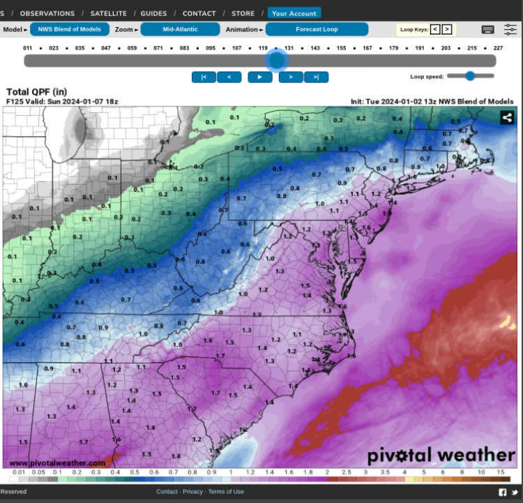
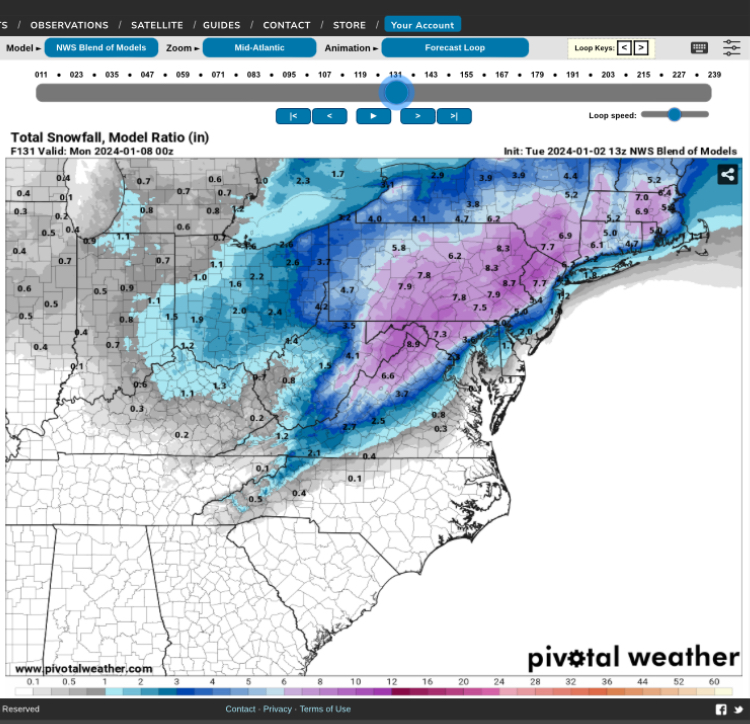
NBM continues to be impressive at leads with the mean QPF and snowfall forecast. Odds are increasing of 1-1.5” QPF during the time frame of the storm, so you can deduce some average ratios of 7-8:1 to as high as 12-14:1 during the storm height within any banding. A pretty good indication of 6-10+” is on the table if all things break correctly.
In-situ cold will be great leading in with drier dew points. That should aid in wet bulbing on the initial surge of low-mid level moisture that’s accustomed to these events. Good trends overall.
-
28
-
4
-
-
32 minutes ago, andyhb said:
I don’t check in here all that often, but I’ll summarize the last few days of model runs for January across most of the CONUS in a couple of words.
Switch. Flipped.
Good seeing you in the sub Andy! Hope all is well down in Norman. If you ever want to take the NWS route, feel free to reach out. Hopefully the southern stream can give you guys some fun later this month through winter.
-
Synoptically, that was a solid run overall. ECMWF is too warm with the thermals in the boundary layer. In fact, it has heavy snow within a deformation band over FDK into central PA with temps at 34F. That's not happening in this setup. Takes the thermals with a grain of salt. UL progression was still good and is well within the envelope of potential outcomes. Fall line and west are still favored and those east and south need to temper expectations. This is a classic storm with those caveats. The CAD is there, but this isn't an arctic driller.
-
22
-
2
-
-
Just now, Eskimo Joe said:
Spelling mistake on my part. I corrected the post.
Ahhh. Gotcha! Happens to the best of us. Could be worse. Imagine seeing it while submitting your discussion at work

-
1 minute ago, NorthArlington101 said:

I can't see the image

-
2 minutes ago, Terpeast said:
Note the trend of the cold HP strength up top on the gefs
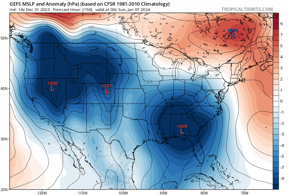
This was what I wanted to see. A better in-situ signature on the lead will work wonders for the initial precip, as well as maintaining a decent PBL profile during any storm height. There's some serious members too on that high. Saw some 1035mb or so readings when looking at the member plots. Great to see.
-
4
-
3
-
-
3 minutes ago, Eskimo Joe said:
DCA and EZF don't stay below freezing at 850 on the 12z GEFS.
You sure about that? The mean at 85H during storm height is -2 with 10th percentile at -4C and 90th at 1C. It was actually a nice showing imo.
-
11
-
-
Just now, WxUSAF said:
I like seeing wider goalposts honestly. The more paths to some sort of event the better. Meanwhile GGEM goes the opposite direction and phases it in much earlier and hence a more inland track and just rain for the 95 corridor.
Canadian is just another solution within the margin of error. It was the snowiest for a succession of runs and now it flips. I'm still in ensemble mode and will be curious to see where the means come in. A storm is 100% in the works, just a matter of how the upper pattern evolves with translation at the surface. Finer details will not be hashed for several more days yet. Everyone should just take the deterministic as a viable solution within the margin.
-
10
-
1
-
-
Just now, WxUSAF said:
Interesting...it doesn't quite phase all the way unlike previous runs. Close, but not quite.
I was noticing that too. The energy is sort of left behind over the OH Valley and it allows the storm to not gain as much latitude. Could very well be noise in this type of setup. What I liked was the persistence of the high over the top and the energy cutting underneath. A little more phasing would've basically produced the ICON simulation. Not a terrible run and actually kind of where you would want to see it in the medium range. GEFS should be pretty
-
10
-

January 6-7 Storm Discussion: we’re due?
in Mid Atlantic
Posted
Funny you mention that because that’s pretty much what the GFS did and is a great way for many to score in this setup. Simplicity is best. A wall of moisture running into cold air with decent mid-level ascent focused over the central Mid Atlantic. These are some of our favorite type of events. They come in hot and slam for 8-12 hrs then scoot out. Typical caveats aside with the fall line and southeast being prone to changing over, but it would offer the opportunity for a period of heavy snowfall before any potential flip. Just one of the possible outcomes in this setup.