Boston Bulldog
-
Posts
823 -
Joined
-
Last visited
Content Type
Profiles
Blogs
Forums
American Weather
Media Demo
Store
Gallery
Everything posted by Boston Bulldog
-
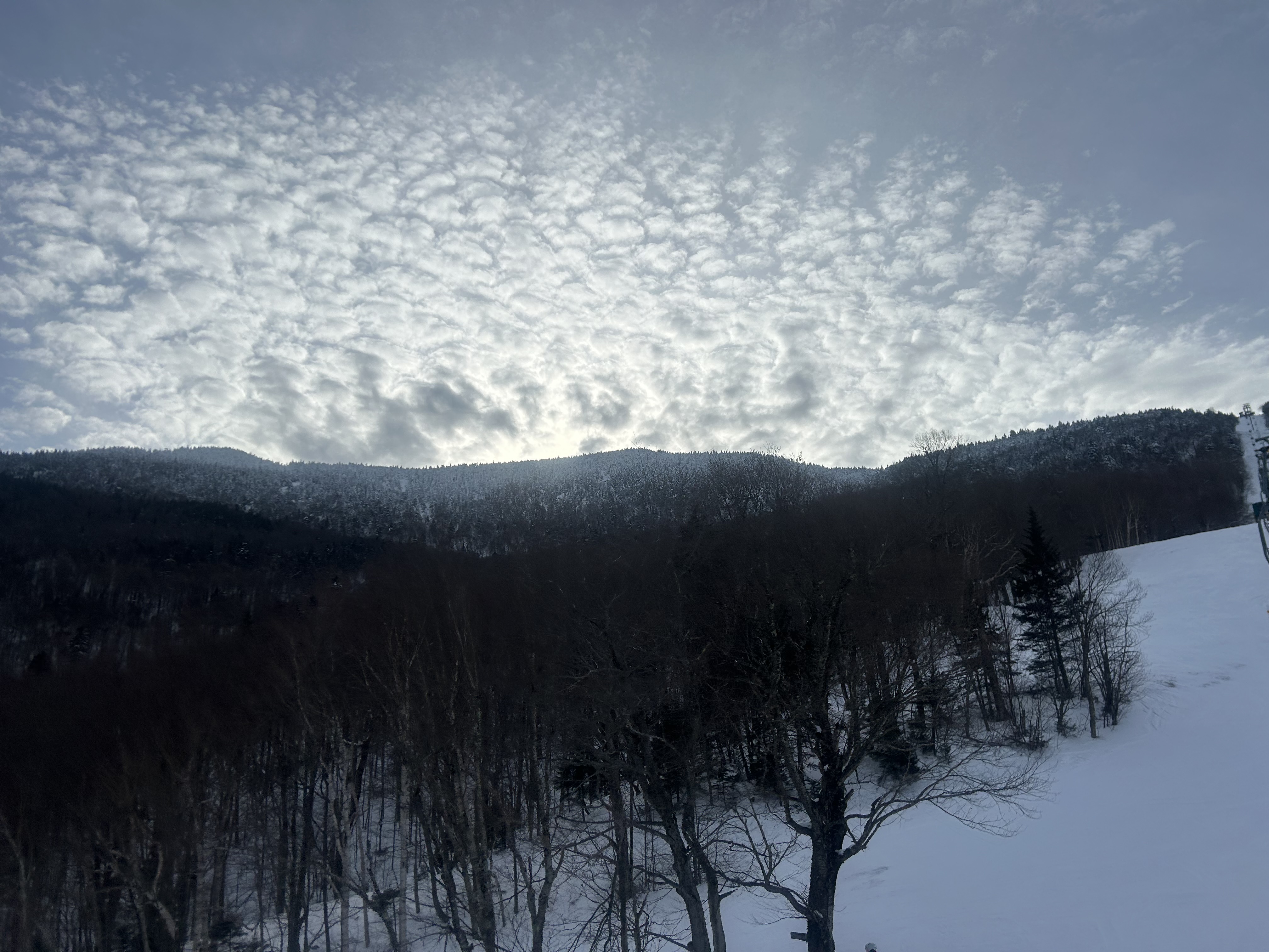
I will always contend that the MRG ridgeline off the Single is some of the most exciting inbounds skiing in the East. Last weekend was no different - Fall Line, Paradise, and the plethora of cliffs and chutes as you push farther out were all in incredible condition. Also, the zone looked beautiful late Saturday afternoon as the sun backlit through altocumulus ahead of the incoming storm.

-
GFS is thumpier for CNE Friday night, both the primary drives farther north and there's a bit more of a handoff to a weak low sliding ENE off Cape Cod
-
I remember for a while this storm looked dead - there was a moderate coastal storm right before it that everyone was complaining was gonna kick this robust setup OTS. Then the 12z runs about 96 hours out or so had a HUGE NW shift… by 0z everyone EOR was in elation. Tons of noise leading up to game time, including the WOR head fake, but I’ll always remember the celebrations when it became clear that this wasn’t going OTS.
-
More southern stream involvement with the clipper Wednesday night on the 0z GFS… but the models have been absolutely all over the place for mid-week. Vorticity features are hundreds of miles apart from run to run. I don’t think this fast flow in the northern stream will be properly resolved for a while. Also the fast flow will make timing difficult for a larger event.
-
Western slopes are a lot thinner than the spine and eastern slopes, but the Teardrop was still a ton of fun. A true tricep burner of an ascent though. Man, they knew how to cut trails back in the 30s.
-
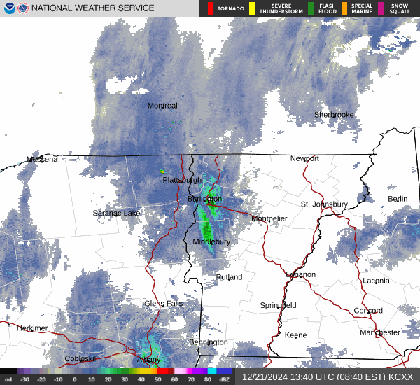
 Any guesses where the mix line is? It’s ripping east at a good clip right now
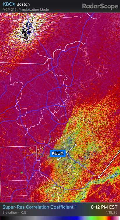
-
Welp so 10” new at MRG… I was wrong lol
-
Radar looks pretty good for the spine right now, but I think BTV is seeing the same moisture issues PF is. Decent downgrade in totals, especially south of 89
-
Been the season of the double that’s for sure. The upper single chair has been getting absolutely crushed by wind pretty consistently.
-
Meh, this all seems like noise to me right now. I'm not taking away too much from 0z so far, some model convergence as expected. Another day or so of maddening model swings (though probably not as dramatic as today) overshadowing ensemble ticks, then we get some improved sampling and we begin to lock in if this thing goes or not. Goalposts narrowing a bit, but still wide.
-
Considering that myself and many other NE Mets will be departing the region for the American Meteorological Society’s annual meeting in NOLA right before this storm, of course it’s going to happen. The atmosphere does have a sense of humor.
-
Gilpin was indeed where I was for most of the day - man it felt deep, especially on the steeper pitch down by the road. 18” or 32”, it was great. I do hope to ski enough powder to eventually be able to discern amounts while in it! When it’s bottomless and flying in my face, tell me any large number and I’ll believe it.
-
Skinned out of Jay Pass today and checked out various lines on both sides of the road… that 32” is legit. Faceshots all day in some zones
-
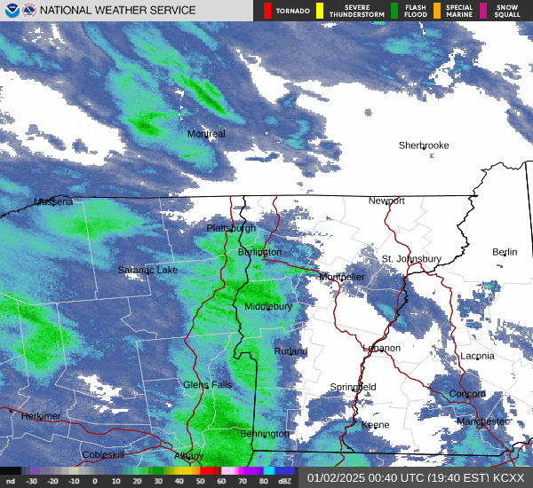
It was dumping on 89 in Montpelier around 7pm. Route 2 was completely snow covered with a few inches as well. This portion of the event was definitely poorly forecast, BTV only had 20-30% PoPs south of 89 for this evening. HRRR had a little hint of some disorganized banding showing up, but guidance totally whiffed on the subtle boundary and upper level energy injection that created the zonally oriented band that extended beyond the mountains.
-
Spine has lit up again, good moisture feed in place across the northern ADK as well
-
Western slope cashing in on blocked flow right now, ski resort cams show that at least some of this is leaking over to the summits
-
Hoping it works out, though BTV did cut down totals a bit after mentioning a potential shorter duration event trend in their AFD.
-
BTV blew the upslope horn on the latest AFD Overall, snow totals look to range from less than an inch in the immediate valleys to 1-2 feet for the highest peaks. Most of the snow will fall during the back end of the storm.
-
While the upslope has seemingly been baked in for a few days now, synoptics have been ticking a bit better for NNE folks in recent runs. The mid level coastal transfer remains a bit of a mess but has trended towards a more coherent and dynamic CMC like solution. I do expect Canadian guidance to back off a bit though.
-
Pasty synoptic snow followed by persistent upslope would be a fantastic way to rebound from this thaw
-
Good sign that random bombs are showing up on guidance. A signal should coalesce as we get closer
-
Despite the coastal system passing well south, I noticed that as the models began to depict an offshore stronger system, there was a bit of an “upslopey” look that developed. It’s likely the deeper intensity of the coastal storm meant that the NW flow got moistened by Atlantic moisture wrapping in from Atlantic Canada. If there’s cold air in place and a strong low over Atlantic Canada, it’s gonna snow along the northern spine of the greens
-
BTV did end up issuing WWAs for the Champlain valley south of Burlington, likely a fluffy 5-6 in the areas most favored by the banding.
-
The Champlain lake effect machine has been turned on!
-
12/20-21 Clipper/Coastal Nowcast and Obs
Boston Bulldog replied to Boston Bulldog's topic in New England
Would assume Blue Hill Observatory was the jackpot