Boston Bulldog
-
Posts
833 -
Joined
-
Last visited
Content Type
Profiles
Blogs
Forums
American Weather
Media Demo
Store
Gallery
Everything posted by Boston Bulldog
-

Blowvember - and not named for wind potential
Boston Bulldog replied to Go Kart Mozart's topic in New England
The hemispheric rossby wave evolution to maintain this pattern is quite remarkable. Happy to get this out of the way in November, myself and many others would be quite angsty if this weirdly persistent pattern showed up in January. The consistent deposit of vorticity back into the western trough really drives the persistence of our downstream ridge. Very impressive how the wave structure strikes the perfect balance between trough attenuation on the low-end of vort advection, and wave breaking for high-end advection. Instead we get stasis. An impressive traffic jam of blocking downstream also slows propagation just in time for vorticity to go reinforce the pattern along the wave axes. Long story short, this ridge doesn’t want to go easy. Again, hoping for a trigger from the W-Pac to reshuffle the deck. -
Blowvember - and not named for wind potential
Boston Bulldog replied to Go Kart Mozart's topic in New England
Exactly, we are pretty locked into eastern ridging for the foreseeable future. Sure, we can get a few cool shots in from various sources here or there, but we need wholesale teleconnection changes for real progress away from the hostile rossby wave configuration we have. Subseasonal indicators are pretty iron-clad right now across the upper latitudes, and tropical forcings are not helping. A nicely timed recurving typhoon could be the trigger for changes sooner than modeled. Until that happens, or other forcings flip key indices, semi-consistent bursts of winter will be confined to the ADK High Peaks region, the Green Mountain spine, the Whites through Pittsburg, and the Mahoosucs/Aroostock county -
Blowvember - and not named for wind potential
Boston Bulldog replied to Go Kart Mozart's topic in New England
I would caution against getting excited about the long range deterministic models showing some “winter-like” storm activity. Ensembles are still very hostile with the ridging through mid month, maybe we can squeeze out a cool shot in about 10 days on the backside of the troughing anomaly over the Maritimes. I would watch for some cutters after mid month with hints of a -PNA showing up. Honestly that’s progress toward a cool season pattern, considering where we are starting this month. -
2024 Atlantic Hurricane Season
Boston Bulldog replied to Stormchaserchuck1's topic in Tropical Headquarters
Organization is there, convection remains quite shallow. I think they could have upgraded at 5pm, but NHC might be looking for more robust convection before doing so. -
Blowvember - and not named for wind potential
Boston Bulldog replied to Go Kart Mozart's topic in New England
Really a pretty awful look for the next few weeks for colder temps. Yuck -
Hard to tell with lack of quality radar, but looks like a direct strike on Grand Turk
-
Current motion seems likely to have the tiny core miss Providenciales, which is fortunate. Grand Turk may not be so lucky
-
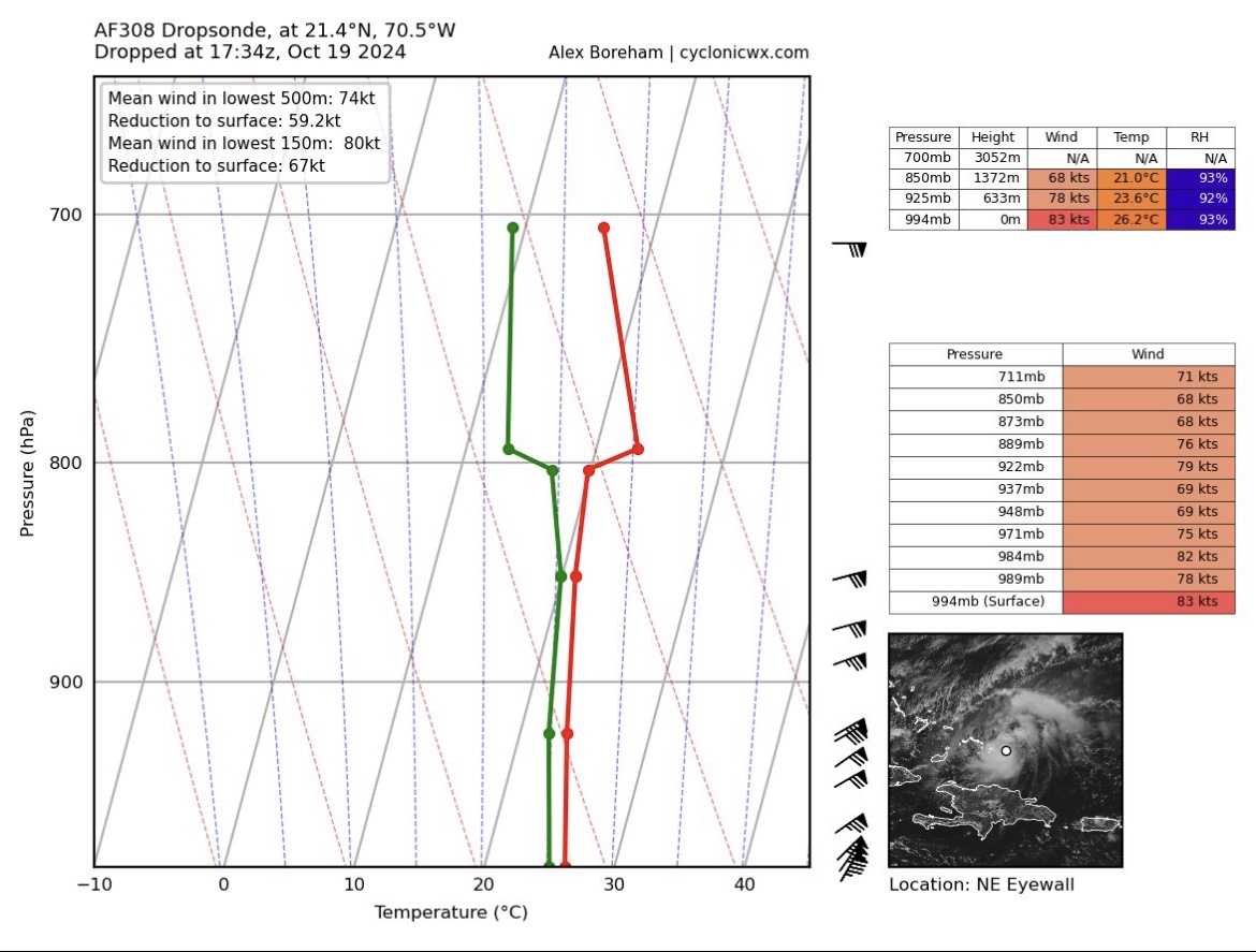
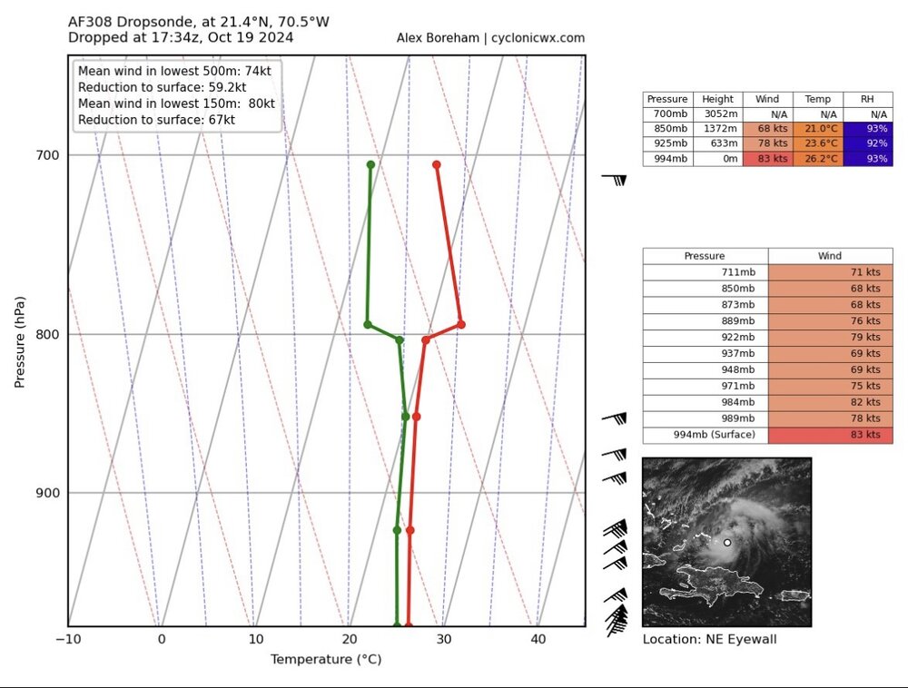
Latest dropsonde shows Oscar on the cusp of category 2. No word on if this is rain affected yet, but Hazelton is giving credence to this result NHC needs to upgrade to hurricane and issue hurricane warnings immediately. It would be negligence if they don’t
-
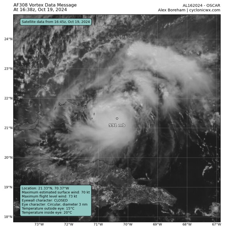
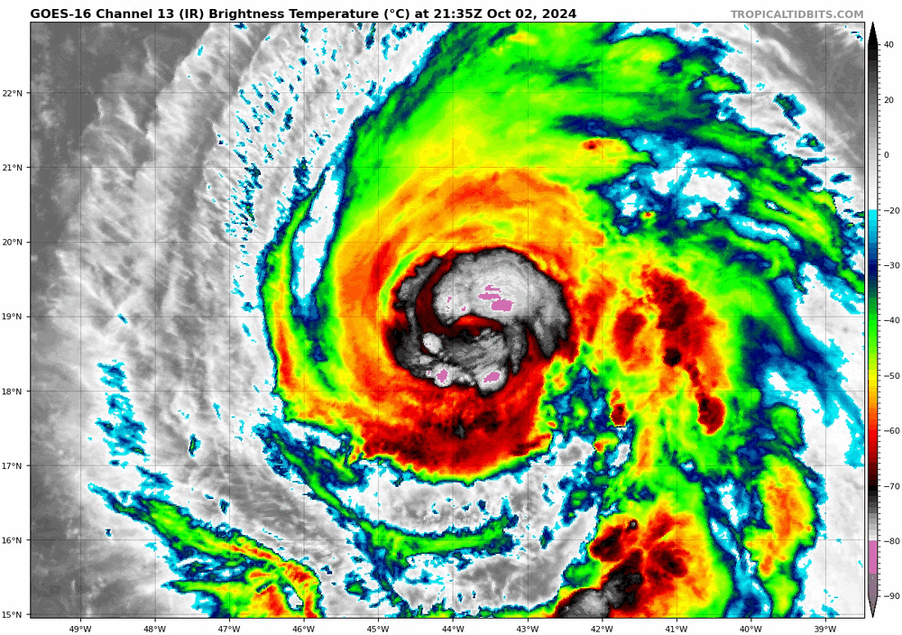
3nm diameter for the eye… take that Milton! NHC special update: 70mph, 991mb
-
Several VHTs rotating around the tiny core on IR sat… wild turn of events this morning
-
Really makes you wonder what recon would have gotten if they flew into Eta at it's peak. Somehow T numbers were higher than Milton's for a brief period there
-
2024 Atlantic Hurricane Season
Boston Bulldog replied to Stormchaserchuck1's topic in Tropical Headquarters
Code Red, might be time to fire up a thread on this. Nasty looking PRE setup. Regardless of how strong this system gets, this is a really concerning situation for an already flooded FL Gulf Coast. Good to see the NHC starting to push out some messaging for coastal residents to prepare.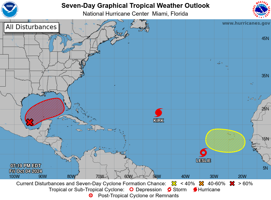
-
NHC agrees, but take the under on daybreak! Kirk has already arrived as a MH!
-
Kirk going beast mode now
-
2024 Atlantic Hurricane Season
Boston Bulldog replied to Stormchaserchuck1's topic in Tropical Headquarters
Isaac just popped an eye. Hurricane at 5am most likely. These mid-latitude systems always have great structure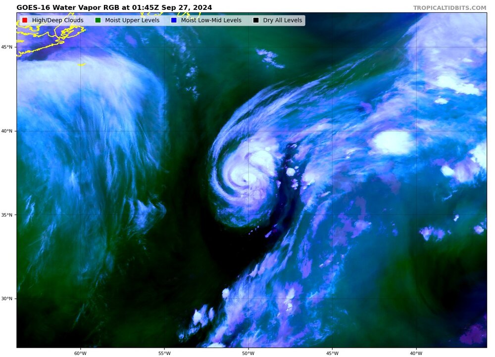
-
Eyewall is starting to look “bumpy” on radar. Plenty of mesovorts starting to emerge, Helene is really tightening up the core now
-
Notable improvement on IR. As a whole the core looks a lot more robust and less hollowed out than just a few hours ago…
-
Central & Eastern Pacific Thread
Boston Bulldog replied to Windspeed's topic in Tropical Headquarters
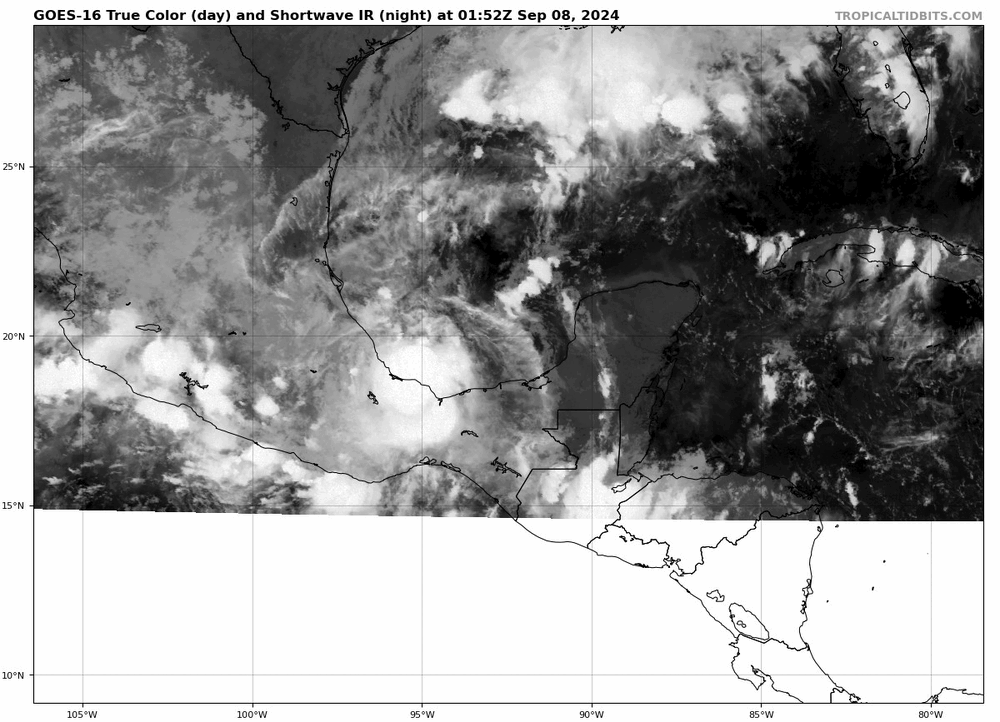
While John has dissipated, the rain has not. Very bad situation unfolding in Oaxaca and Guerrero states, regardless if Zombie John re-emerges like the NHC says it has a 50% chance of doing -
Data will often be noisy in a chaotic environment. This is why many different measurements are needed for official statistics. I would recommend saving yourself from eye strain from obsessing over each datapoint, and look at overall trends in pressure
-
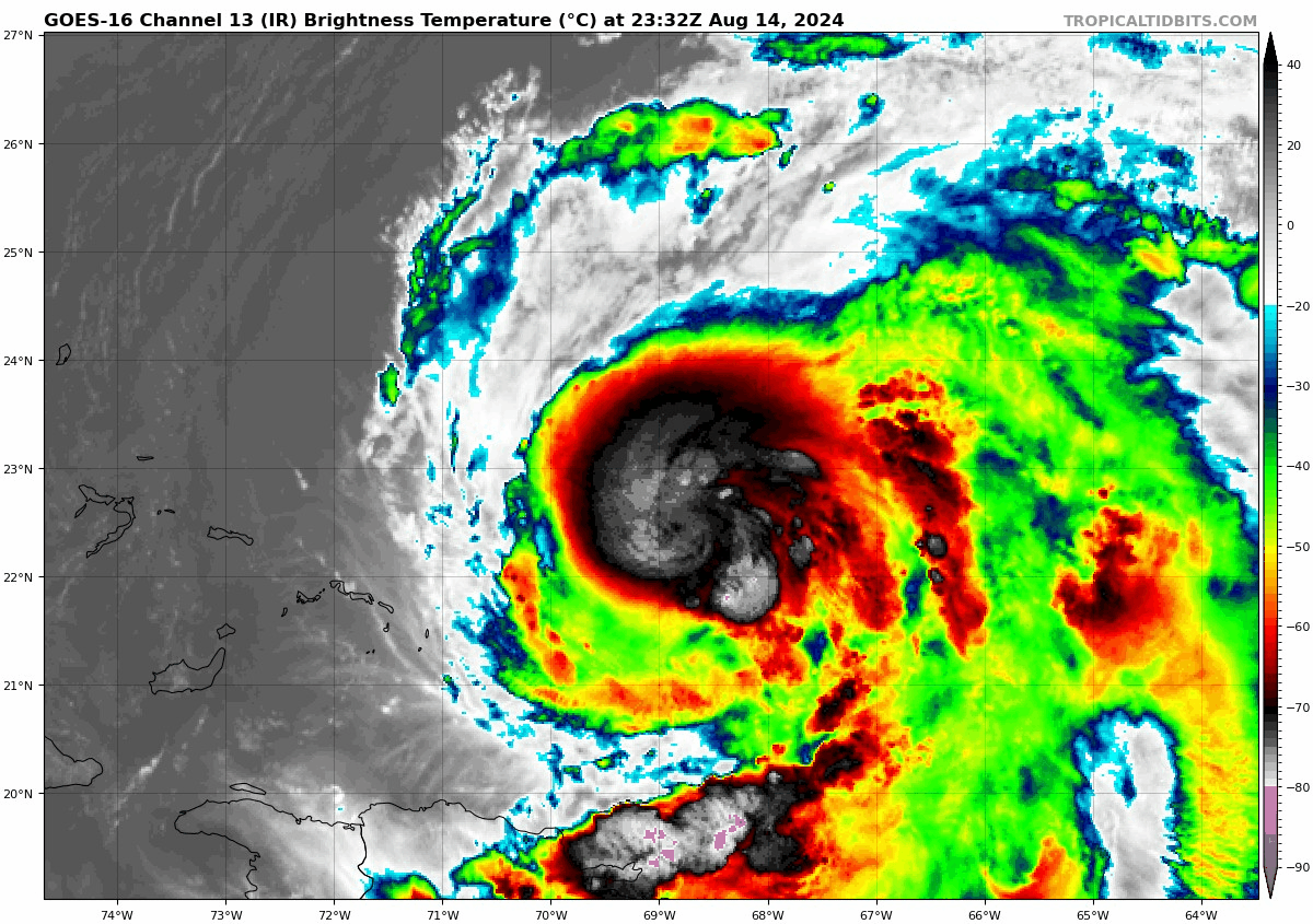
Man this thing is a behemoth, look at that gigantic outer band draped over Jamaica. These CAG storms can bring quite the vorticity payload as they head north. Major rossby wave perturbations likely downstream as Helene rots in the mid-latitudes. I haven’t looked, but this would likely be a “reshuffle the deck” situation for the extratropical circulation across the N-ATL and Europe
-
Giving any serious consideration to Hurricane models before a center of circulation has formed is totally foolish. HAFS at 12z had this thing already vertically stacked by this time
-
That’s the eye
-
Fascinating and dynamic satellite view of the Western Gulf tonight. Look at that circulation around 27N start to accelerate south and get pulled closer to the wave axis
-
Powerful ET transitions are rare on radar and wow what a slug of moisture heading for the Avalon Peninsula. Interesting to see all the frontal features becoming more dominant in real time. Big time fronto-band fueled by deep tropical moisture heading for St John's. That's gonna pack a punch.
-
Quite the burst of convection that managed to rotate upshear and around the center. I would expect another burst on the eastern side of the center soon. You can see dry air getting ingested to the south via the northwesterly shear - it is trying to rotate into the center around 69W 22N. The inner structure of the core is a bit of a mystery right now due to the lack of new microwave passes, let's see if Ernesto can wall off the dry air