Boston Bulldog
-
Posts
824 -
Joined
-
Last visited
Content Type
Profiles
Blogs
Forums
American Weather
Media Demo
Store
Gallery
Everything posted by Boston Bulldog
-
11" nearby at the base of Magic! A rare Tuesday opening tomorrow
-
 This deform area over Albany has been great. Consistent moderate to heavy snow all morning Totals are a bit lower in the valley due to some mixing that occurred overnight, but this morning's performance has certainly made up for that
 -
Control run would be c00. I don't think it shows up here
-
Power is back at Magic, game on!
-
Have a ticket for Magic tomorrow, nervously awaiting the news regrading power. Seems like they’ll have nearly the entire mountain open if they can get power. If not, Whiteface it is
-
Preliminarily ... a medium impact partial Miller B, Friday
Boston Bulldog replied to Typhoon Tip's topic in New England
Gonna be difficult to verify the WSW here, but steady moderate snow now and accumulating at a decent clip. Once the sun went down the switch flipped -
Preliminarily ... a medium impact partial Miller B, Friday
Boston Bulldog replied to Typhoon Tip's topic in New England
Looks like we have finally changed over to 100% snow in ALB -
Preliminarily ... a medium impact partial Miller B, Friday
Boston Bulldog replied to Typhoon Tip's topic in New England
Hour 13 of white rain here. Uptown near Colonie does seem to have a bit of a coating down on grassy surfaces as of an hour ago, so accumulations are getting closer. Hoping that we start to gain some traction as the wind shifts later today. This has been a true introduction to the Hudson Valley, no doubt about that. At least the mountains are getting pounded. Magic may open on Sunday now -
Preliminarily ... a medium impact partial Miller B, Friday
Boston Bulldog replied to Typhoon Tip's topic in New England
Yeah nothing more than white rain at the moment -
Preliminarily ... a medium impact partial Miller B, Friday
Boston Bulldog replied to Typhoon Tip's topic in New England
Rain mixing with aggregates in downtown Albany now -
Fairfield County Crusher 12/11-12/12
Boston Bulldog replied to Go Kart Mozart's topic in New England
Yeah we had a great 30+ DBZ band sit over us for a while. Nice overperformer in the Capital Region -
Fairfield County Crusher 12/11-12/12
Boston Bulldog replied to Go Kart Mozart's topic in New England
Moderate to heavy snow in downtown Albany. Roads are covered -
Tough news out of Magic Mountain regarding progress on the Black chair: https://magicmtn.com/alpine-update/ What stood out to me is that the timeline for the lift has been pushed back to "carrying passengers at some point this season if all goes well". With the lack of resources available to Magic ownership, and the difficult nature of the new projects they need to complete before the lift can spin, I think its a safe bet the Quad won't spin this year. Pretty unfortunate as the general unreliability of the Red Chair can leave them without summit access for extended periods. I hope they can catch a break and finally complete the project as it's pretty essential to securing the future of Magic. Such a great mountain with amazing terrain. I still am hoping to get 3-4 days in there when (if?) the base is good in SVT.
-
6 inches at Breckenridge last night which already eclipsed forecasted snow totals for the week. 4 at Copper, 1-3 elsewhere. Another backdoor pulse of energy is coming down the trough tonight, perhaps a few more inches in favored areas. While this fluff won't do too much for the SWE of the snowpack, it is nice to see CO cash in a bit after just missing out on last weeks bonanza.
-
Perhaps a bit of a sleeper NW flow event for Summit County and other favored areas this week. Positioning on the upstream side of the trough is conducive enough to bring decent amounts of jet energy into the region, so I would expect orographically favored spots should be able to squeeze out some good localized showers over the next few days. Breckenridge already showing decent accumulation, I think some ski areas might be pleasantly surprised over the next few days.
-
Amazing totals out west, though Colorado seems to be getting mere scraps. Hoping they cash in and build a good base before the January AMS conference in Denver
-
Fully tropical now according to NHC
-
Any of the Cottonwood resorts (Alta, Snowbird, Brighton, Solitude) in Utah are probably your best bet due to their unique microclimate. Snowbird and Alta are the largest out of those, and receive the highest annual snowfall of any US resort outside of the Cascades/Sierras. Those two average around 500" a season, while nearby Park City typically sees totals in the 300"-400" inch range, so the Cottonwoods have an advantage over other areas even locally thanks to their microclimate. Utah can get unlucky and get stuck in extended dry periods from time to time, so the most "coverage proof" early season resort in North America is probably Whistler above mid mountain. The base area gets warm and can flip to rain during some storms, but with a 5000ft vertical drop its not hard to find good coverage up top. Wolf Creek and Targhee are good bets as well, but on the smaller side. Larger spots in CO, as well as Jackson Hole and Big Sky, need a lot of snow to fill in their terrain so openings aren't as reliable by Christmas.
-
Some impressive gravity wave signatures showing up on radar training over the Hudson River Valley right now. Absolutely pouring, but not much wind to speak of thus far
-
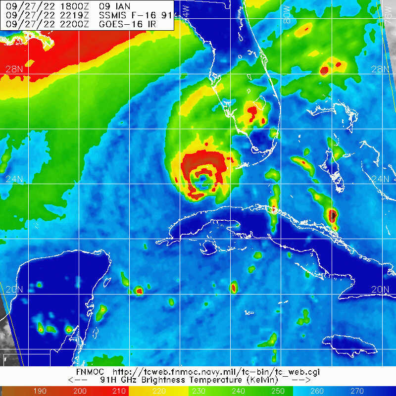
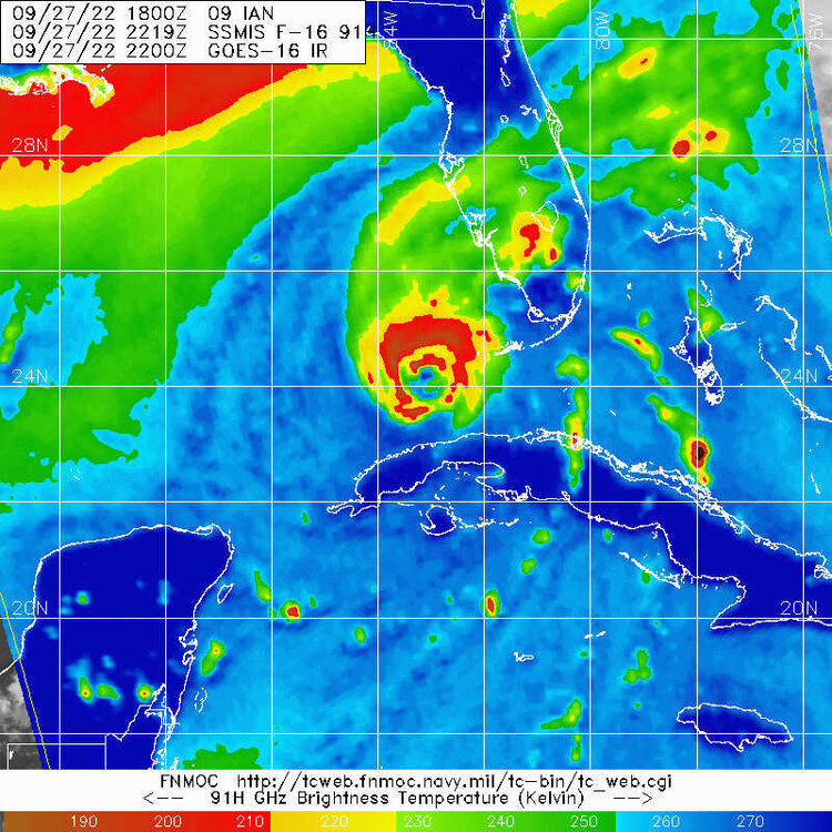
You aren't kidding, suspicious looking curved band on the north side of the center per the last SSMIS pass
-
https://www.metoc.navy.mil/fnmoc/tropical.html Click on the Satellite Imagery of Tropical Cyclones link. It often gives a "not secure" warning, just as a heads up. Probably one of the more comprehensive pages for TC information
-
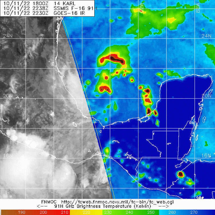
SSMIS pass shows the outer eyewall making progress, but still open to the south
-
As the effects of Typhoon Merbok on the general NH longwave pattern, CONUS wavebreaking event, and subsequent downstream trough come into focus, we should start to see more of a consensus develop on the future of Fiona. The ultimate destination of this system (if it survives the Greater Antilles intact) will be beholden to the structure of the rossby wave pattern. The run to run differences in the positioning of the 500mb trough on the Euro and GFS runs remains quite significant, and likely won't be resolved until ET Merbok completes building the ridge over the Aleutians and the Bering Sea.
-
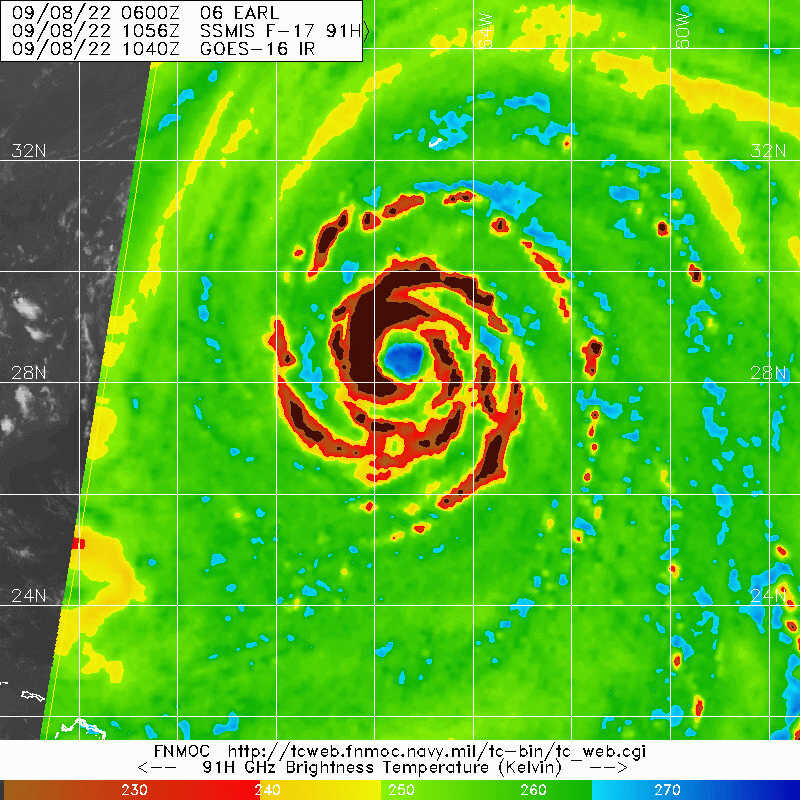
Quite the beefy eyewall taking shape on the latest SSMIS microwave imagery

-
Thinking Earl may peak at a similar intensity to Larry last year given the similarities in the structure of the eye (though far more banding features are present with Earl)