Boston Bulldog
-
Posts
823 -
Joined
-
Last visited
Content Type
Profiles
Blogs
Forums
American Weather
Media Demo
Store
Gallery
Everything posted by Boston Bulldog
-
Bright banding approaching Canton MA as the column saturates and precip picks up, would love to see some flakes mix in. 39/31 right now so I'm skeptical there is enough oomph behind the wet bulb to do the trick. Correlation coefficent is hinting that some mixing may be to the NW, slicing through Dedham and Westwood, so good rates are gonna be needed for that to crash south. Hardly has gotten into the 30s at all this year down in the tropics (Manhattan), never really understood how powerful the heat island is there until I moved there. Appreciating the wintery feel up here today
-
Wow, NWS had zilch and the HRRR had about 0.5" for Albany. Nice little overperformer over there
-
Great looking band heading into Southern VT and the Berkshires!
-

Central & Eastern Pacific Thread
Boston Bulldog replied to Windspeed's topic in Tropical Headquarters
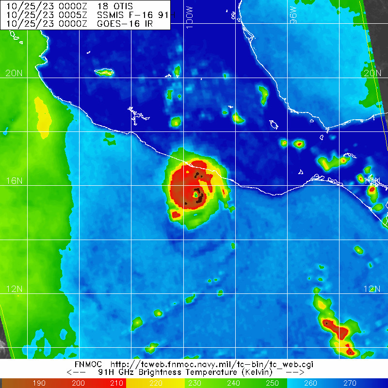
A sensational and horrifying microwave pass on Otis
-
Octorcher or Roctober 2023 Discussion Thread
Boston Bulldog replied to Damage In Tolland's topic in New England
Been a bit tuned out on recent developments for our weekend storm, so I only just now have caught up on how this thing has trended... what a shame if this was January. Hopefully we are getting our blown phases out of the way in the preseason (at least according to the GFS) Looking at the Z500 evolution is especially painful with the southerly vort getting slung out east. Make no mistake about it, this would be a solid hit, but more in the "close but no cigar" caliber rather than a true classic. One final note, take a look at a rare October Manitoba Mauler diving into the midwest upstream of our weekend storm. Seems like the clipper train has really dried up in recent years, maybe getting it going early is a good omen? -
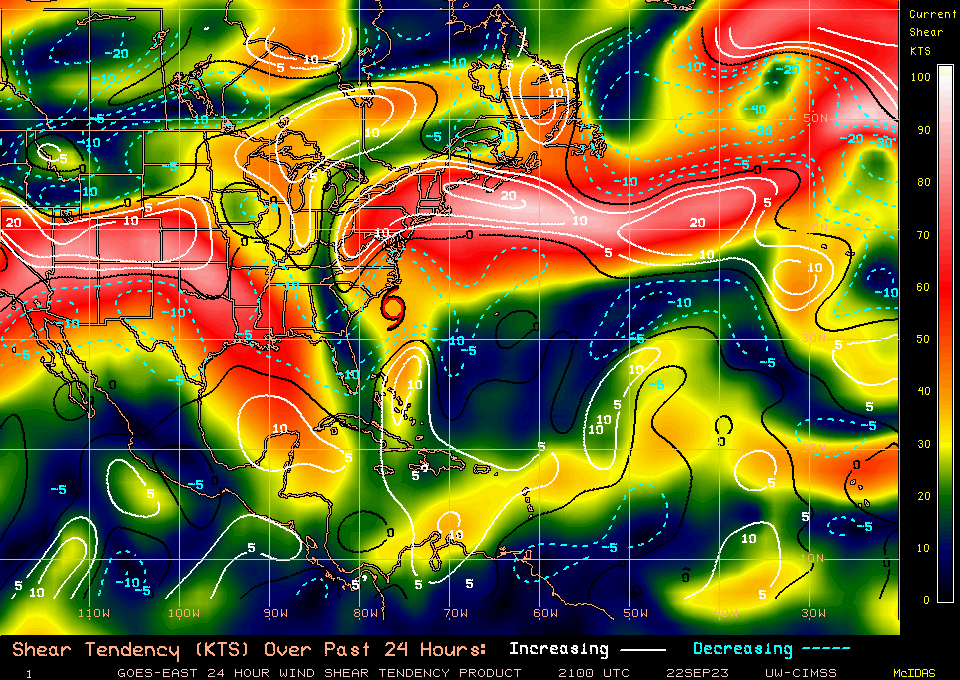
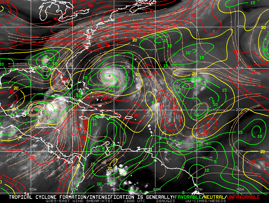
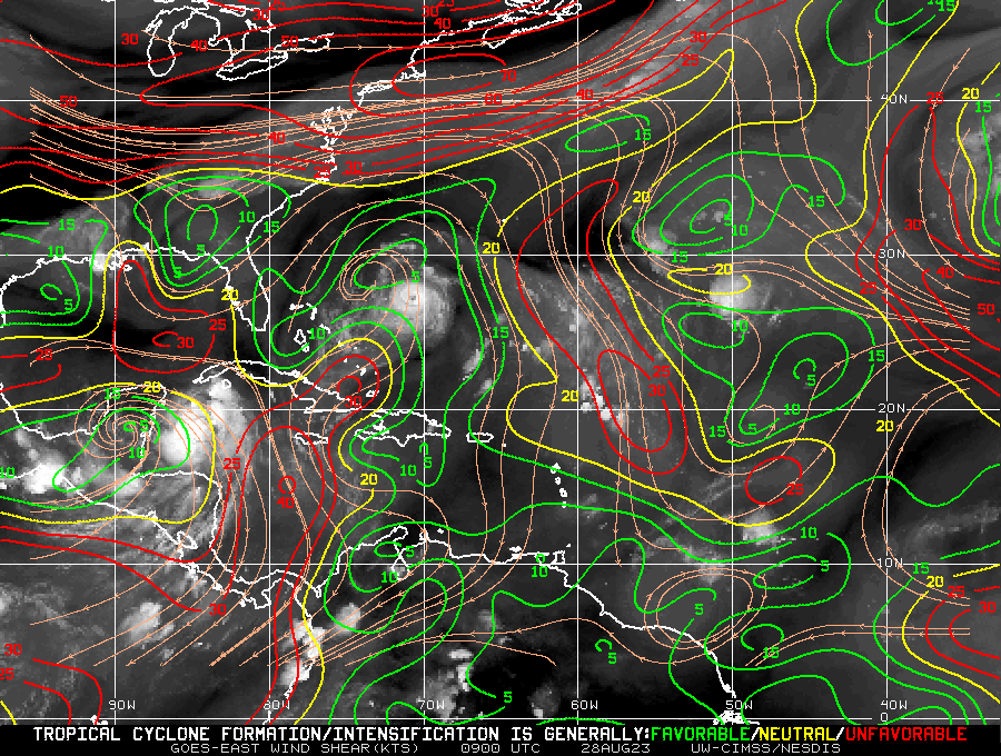
Can anyone guess the direction of the shear over the western MDR this morning?
-
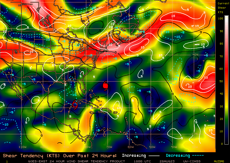
Still lots of shear over Ophelia, but a pretty strong weakening trend in shear values. It's pretty easy to tell why this has managed to wrap up it's core a bit
-
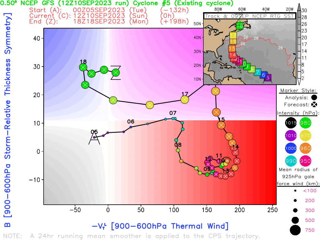
Some initial guidance on Lee's eventual extratropical transition as it parallels the East Coast

-
-
Pretty spot on. Spatial gridding resolution for global model outputs are significantly more coarse than mesoscale models. This is especially true when compared to hurricane models like HWRF or HAFS that can "telescope" in on hurricanes and move with them in space and time with storm following nests. Here is a great BAMS article on hurricane model "nesting" for those who want to learn more: https://journals.ametsoc.org/view/journals/bams/103/3/BAMS-D-20-0134.1.xml Tight pressure gradients, such as the inner core of an intense hurricane, are on the subgrid scale and thus the model will interpolate values for given variables to fill the gap between grid points. Interpolation algorithms will not be able to correctly render the pressure gradient surrounding the MSLP of an exceptionally deep TC, hence why we see so many models initialize runs at significantly higher pressures.
-
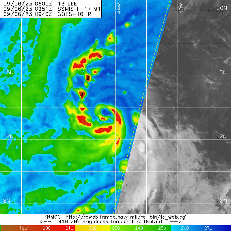
Lee already has an impressive inner core structure despite the E-NE shear its been dealing with

-
2023 Atlantic Hurricane season
Boston Bulldog replied to Stormchaserchuck1's topic in Tropical Headquarters
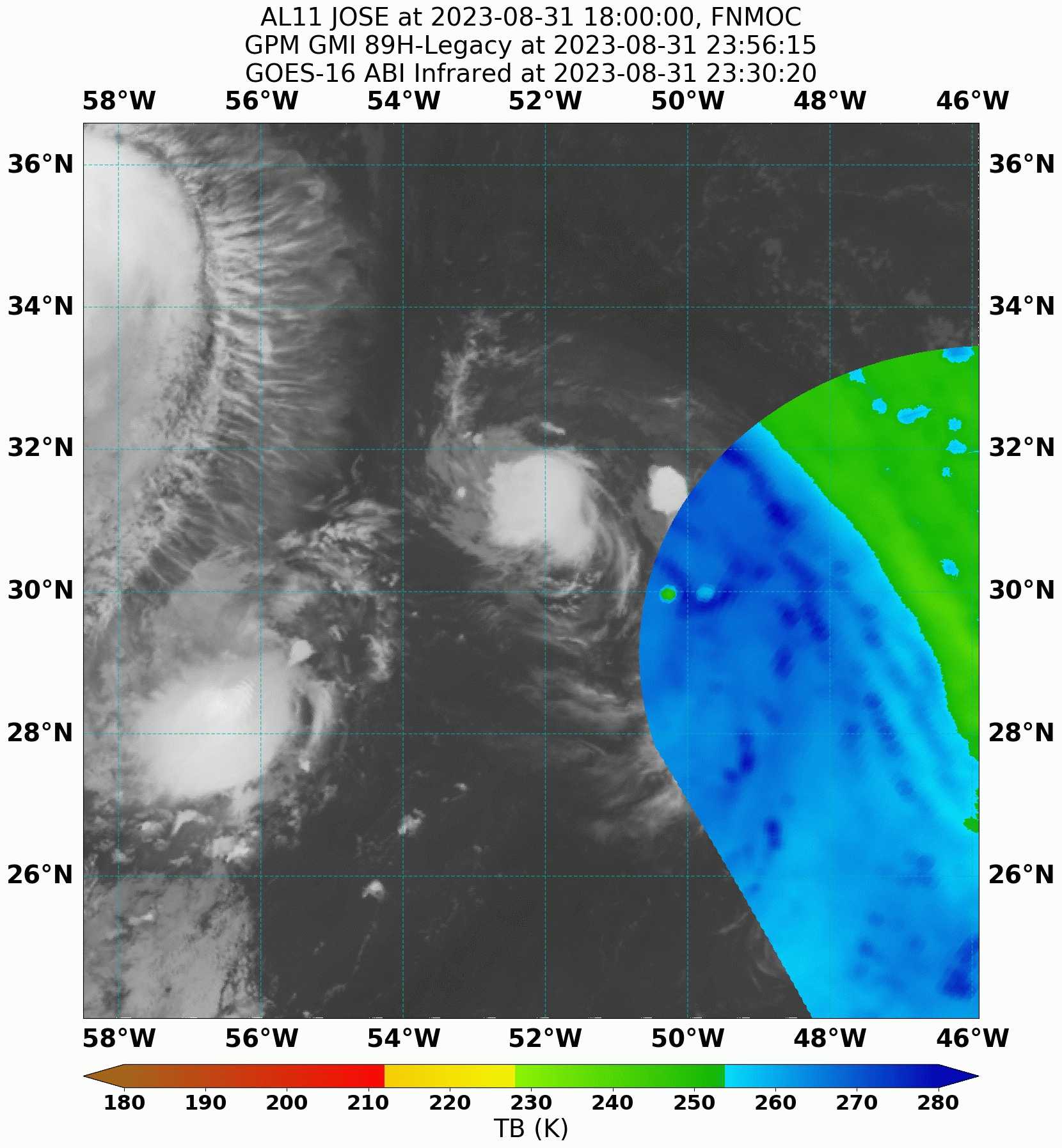
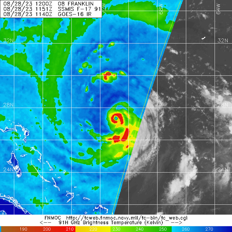
Brutal miss on the latest pass of GMI for Jose Regardless, interesting discussion included in tonight's 11pm EDT package. Yet another innocuous spin-up in the subtropics defying expectations. A clean shave of Jose's convection is likely incoming tomorrow once Franklin draws closer. Tropical Storm Jose Discussion Number 11 NWS National Hurricane Center Miami FL AL112023 1100 PM AST Thu Aug 31 2023 Jose is a tiny tropical cyclone with the convective cloud tops only extending 50 to 60 n mi across. However, geostationary satellite and microwave images indicate that the storm has a tight circulation with evidence of a mid-level eye feature. A recent ASCAT pass showed peak winds in the 40-45 kt range, but since the system is so small that instrument likely can not resolve the peak winds. The initial intensity is increased to 50 kt, which is above the Dvorak estimates. Jose is likely near its peak intensity. There is no way Jose will escape the outflow associated with Hurricane Franklin, that is expected to begin affecting the small storm by midday Friday. Therefore, the forecast shows a steady weakening trend until it becomes absorbed by Franklin in about 36 hours. The storm is moving northward at 11 kt and is moving in the flow between Franklin and a mid-level ridge over the central Atlantic. A faster motion to the north is expected until the system dissipates on Saturday. The NHC track forecast is slightly to the west of the previous one. FORECAST POSITIONS AND MAX WINDS INIT 01/0300Z 32.7N 52.4W 50 KT 60 MPH 12H 01/1200Z 35.5N 52.0W 40 KT 45 MPH 24H 02/0000Z 39.9N 51.1W 35 KT 40 MPH 36H 02/1200Z...DISSIPATED $$ Forecaster Cangialosi/Bucci/Fritz
-
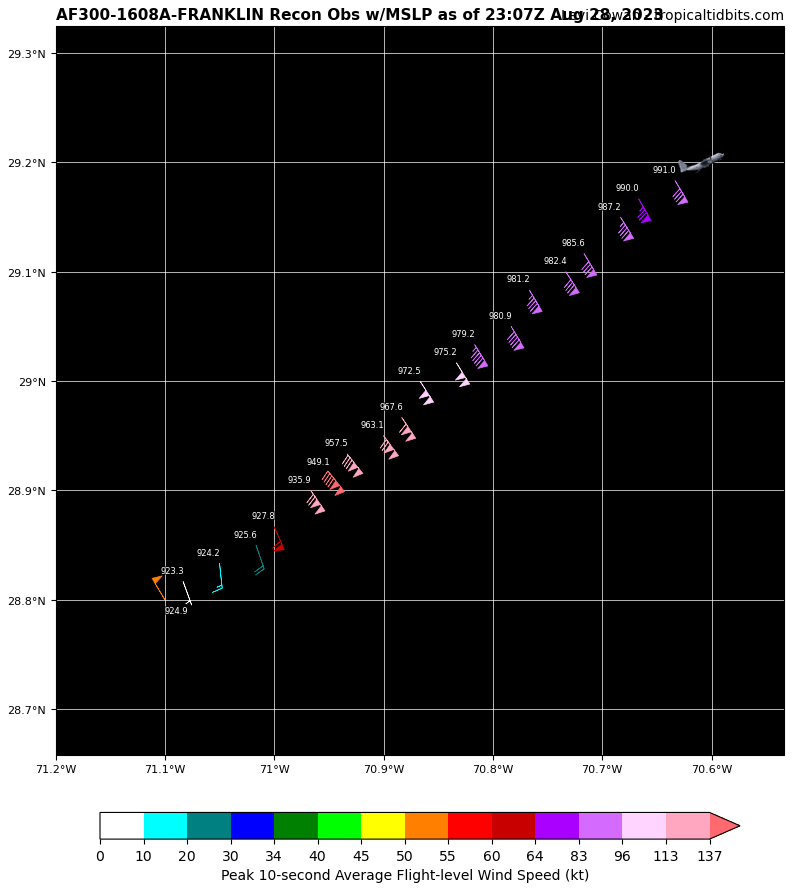
I will admit I am unsure if that is flight level winds or not. SFMR adjusted is 128kts
-
923.3mb per recon EDIT: 140kts it appears. That's a category 5 230030 2855N 07057W 6982 02635 9491 +100 +059 141136 140 128 028 0

-
Stage is now being set for Idalia to organize significantly once it clears Cuba and enters the gulf
-
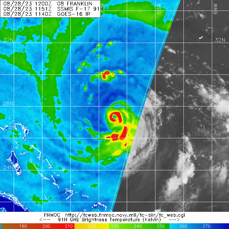
Now we are seeing signs of one, though the inner eyewall is very thick

-
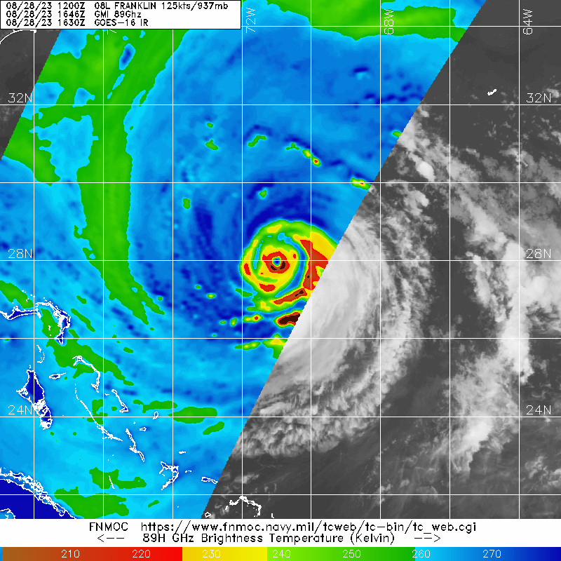
No sign of EWRC yet. A run at Cat 5 is not out of the question today.
-
If an absurd RI episode happens over the fish, but there's a gulf storm brewing, did it even happen? 145mph...what a shocking update lol
-
Now sonde #9 is labeled as in the eye. VDM will be telling
-
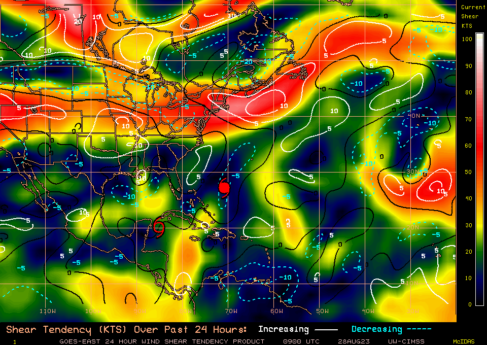
Not quite sure where the shear is decreasing narrative has come from. Currently the storm is dealing with moderate shear which is tilting the core despite the strong convection. We've observed several wrap up attempts that have failed so far, which is likely due to this ~15-20kts of shear, and some dry air still showing up around 800 hPa on dropsonde data. There has been no observed decrease in vertical wind shear over the past 24 hours ahead of the system or over the system. Idalia will remain under similar conditions as it lifts into the gulf. We may see a period of little to no shear as the flow switches direction while the tough approaches (likely when we will see the strongest chance for RI). From there the trough will begin to increase vertical shear again, this time southerly. However, favorable synoptic interaction with the equatorward entrance region of the jet streak that will be traversing the eastern US at this time will likely offset the negative effects of this southerly shear as Idalia approaches landfall thanks to diffluence. Just speculating here, but I wonder if this southerly shear and dry air behind the system at landfall would eat away at the back eyewall upon approach, as we have seen with so many other gulf "halficane" landfalls in recent years EDIT: Fixed poleward to equatorward
-
Wow, it looks like all systems are go tonight. Very interested in what recon shows regarding the character of this developing core. 60mph and 992mb. Tropical Storm Idalia Discussion Number 6 NWS National Hurricane Center Miami FL AL102023 1000 PM CDT Sun Aug 27 2023 Idalia's center has become embedded beneath a large burst of deep convection, with overshooting cloud-top temperatures as cold as -82 degrees Celsius. NOAA buoy 42056, located just to the east of the center, has reported maximum 1-minute sustained winds as high as 45 kt within the past hour or two. The anemometer height of the buoy is 4 meters, so converting the wind to a standard 10-meter height indicates that Idalia's intensity is now up to at least 50 kt, which is the initial intensity for this advisory. An Air Force Reserve reconnaissance aircraft is scheduled to investigate Idalia in a few hours. The center has been moving erratically since earlier today, and may have even sagged southward, pulled toward the recently developed deep convection. A northward motion is expected to begin on Monday and continue through Tuesday as Idalia moves between a mid-level trough over the central Gulf of Mexico and strengthening ridging over the Greater Antilles. After 48 hours, a gradual turn toward the northeast and then east is anticipated due to a deeper trough that is expected to swing across the Great Lakes. No significant changes were required for the updated NHC track forecast compared to the previous prediction. The spread among the track models remains relatively low, and the official track continues to lie closest to the ECMWF and HCCA consensus aid. Idalia is sitting over very warm waters of about 30 degrees Celsius, and when it moves northward, it will be over the even deeper warm waters of the Loop Current in 24-36 hours. Although the trough over the Gulf could impart some shear over the system, this is likely to be offset by upper-level diffluence. Idalia has already strengthened more than anticipated, and the environment looks ripe for additional intensification, possibly rapid. The NHC intensity forecast has been increased and lies at the upper bound of the guidance. The new prediction now shows a 95-kt hurricane over the eastern Gulf of Mexico at 48 hours, but it should be stressed that additional strengthening to major hurricane strength is becoming increasingly likely before Idalia reaches the Gulf coast of Florida. Interests within the storm surge and hurricane watch areas are urged to prepare for possible significant impacts and monitor future updates to the forecast. KEY MESSAGES: 1. Idalia is forecast to become a hurricane by the time it reaches the southeastern Gulf of Mexico, and it could be near or at major hurricane strength when it reaches the Gulf coast of Florida. The risk continues to increase for a life-threatening storm surge and hurricane-force winds along portions of the west coast of Florida and the Florida Panhandle beginning as early as Tuesday. Storm surge and hurricane watches are in effect for portions of the west coast of Florida and the coast of the Florida Panhandle, and residents in these areas should monitor updates to the forecast and follow any advice given by local officials. 2. Scattered flash and urban flooding is expected across portions of the west coast of Florida, the Florida Panhandle, and southern Georgia late Tuesday night through Wednesday. Heavy rainfall may lead to flash flooding across portions of the Carolinas Wednesday into Thursday. 3. Hurricane-force winds are expected across portions of far western Cuba late Monday. Heavy rainfall is expected across portions of the eastern Yucatan and western Cuba and may produce areas of flash and urban flooding as well as landslides across western Cuba. FORECAST POSITIONS AND MAX WINDS INIT 28/0300Z 19.8N 85.3W 50 KT 60 MPH 12H 28/1200Z 20.7N 85.1W 60 KT 70 MPH 24H 29/0000Z 22.2N 85.0W 70 KT 80 MPH 36H 29/1200Z 24.2N 84.9W 80 KT 90 MPH 48H 30/0000Z 26.8N 84.3W 95 KT 110 MPH 60H 30/1200Z 29.6N 82.8W 85 KT 100 MPH...INLAND 72H 31/0000Z 32.0N 80.1W 55 KT 65 MPH...OVER WATER 96H 01/0000Z 34.3N 73.4W 50 KT 60 MPH 120H 02/0000Z 34.4N 67.8W 50 KT 60 MPH
-
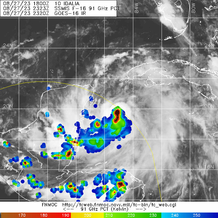
Well timed microwave pass gives us a good look under the hood
-
Dry air to the north still remains upshear of the storm. While this recent pulse is the most impressive we've seen, Idalia hasn't done much to moisten the environment ahead of it, as such this dry air will continue be pushed into and entrained within the circulation. Unlikely that this current convection over the center will maintain itself long enough to facilitate substantial organization before dry air eats away at it a bit.
-
No recent microwave data to confirm this, but IR satellite seems to indicate that Franklin may be about to clear out its eye. CBs have been making full rotations around the eyewall in recent hours. Perhaps the eastern eyewall disruption has been alleviated
-
2023 Atlantic Hurricane season
Boston Bulldog replied to Stormchaserchuck1's topic in Tropical Headquarters
TD-6 has been upgraded to Gert...unfortunately. Needless to say I don't think this one's going to put up a lot of ACE Tropical Storm Gert Special Discussion Number 7 NWS National Hurricane Center Miami FL AL062023 1200 AM AST Mon Aug 21 2023 Recent satellite wind-derived data indicated that winds in the northeast quadrant were a little over 35 kt. Conventional enhanced infrared imagery showed cooling cloud tops of -85 Celsius in the same region of the cyclone. Accordingly, the depression is upgraded to a tropical storm on this Special Advisory. No changes to the forecast track and intensity philosophy are required. Since the environment is still expected to be hostile with very strong westerly shear during the next day or so, Gert should degenerate into a remnant low later today, and dissipate by Tuesday. FORECAST POSITIONS AND MAX WINDS INIT 21/0400Z 16.7N 55.9W 35 KT 40 MPH 12H 21/1200Z 16.8N 57.1W 25 KT 30 MPH...POST-TROP/REMNT LOW 24H 22/0000Z...DISSIPATED $$ Forecaster Roberts