


hudsonvalley21
-
Posts
4,289 -
Joined
-
Last visited
Content Type
Profiles
Blogs
Forums
American Weather
Media Demo
Store
Gallery
Everything posted by hudsonvalley21
-
Maybe my Davis is on steroids but 1.88 before midnight and another 0.79 for an event total of 2.67. Interested to see how the totals around stack up.
-
Maybe my Davis is on steroids but 1.88 before midnight and another 0.79 for an event total of 2.67. Interested to see how the totals around stack up.
-
As of 9:30, 1.82 in the bucket with light rain falling. Dew point now down to 63.
-
Wind direction has flipped to s/w here from s/se dew pt is 70. High dew pt for the day was 73.
-
Did they use the snowguns from stony ford aka your back yard
-
0.85 here so far. Mostly from the thunderstorms that rolled thru in the last hour. The National Weather Service in Upton has issued a * Urban and Small Stream Flood Advisory for... Orange County in southeastern New York... Rockland County in southeastern New York... * Until 1045 PM EDT. * At 552 PM EDT, Doppler radar indicated heavy rain due to thunderstorms. This will cause urban and small stream flooding. * Some locations that will experience flooding include... New City, Newburgh, Middletown, Monsey, Nanuet, Haverstraw, Suffern, Port Jervis, Monroe, Walden, Nyack, West Point, Warwick, Goshen, Sloatsburg, Howells, New Windsor, Pearl River, Orangeburg and Gardnertown.
-
Yea I know, you are referring to Perdue when saying “that team”
-
Nice, hope you were able to get a couple tickets to the game.
-
0.46 here, heavier stuff just to the north and west of me too.
-
Special Weather Statement National Weather Service New York NY 909 PM EDT Wed Sep 15 2021 NJZ002-103-NYZ067-069-160215- Western Bergen NJ-Western Passaic NJ-Rockland NY-Orange NY- 909 PM EDT Wed Sep 15 2021 ...A STRONG THUNDERSTORM WILL IMPACT PORTIONS OF PASSAIC, NORTHWESTERN BERGEN, SOUTHEASTERN ORANGE AND ROCKLAND COUNTIES THROUGH 1015 PM... At 908 PM EDT, Doppler radar was tracking a strong thunderstorm over Ogdensburg, or 7 miles east of Newton, moving northeast at 30 mph. HAZARD...Winds in excess of 40 mph and pea size hail. SOURCE...Radar indicated. IMPACT...Gusty winds could knock down tree limbs and blow around unsecured objects. Minor damage to outdoor objects is possible. This strong thunderstorm will be near... West Milford around 930 PM EDT. Upper Greenwood Lake around 935 PM EDT. Ringwood around 940 PM EDT. Warwick and Greenwood Lake around 945 PM EDT. Sloatsburg around 950 PM EDT. Monroe around 1000 PM EDT. Pomona and Harriman around 1005 PM EDT.
-
Even smaller now.
-
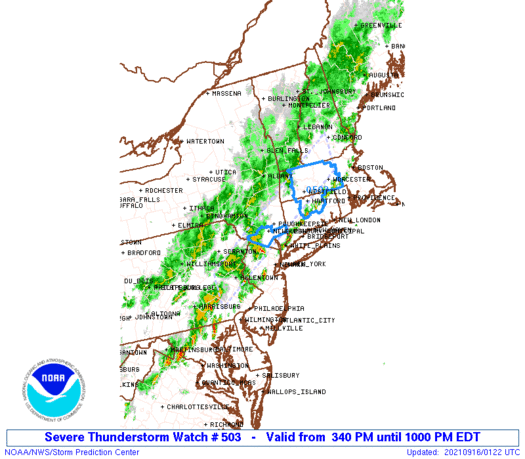
SEVERE THUNDERSTORM WATCH OUTLINE UPDATE FOR WS 503 NWS STORM PREDICTION CENTER NORMAN OK 340 PM EDT WED SEP 15 2021 SEVERE THUNDERSTORM WATCH 503 IS IN EFFECT UNTIL 1000 PM EDT FOR THE FOLLOWING LOCATIONS NYC027-071-079-160200- /O.NEW.KWNS.SV.A.0503.210915T1940Z-210916T0200Z/ NY . NEW YORK COUNTIES INCLUDED ARE DUTCHESS ORANGE PUTNAM
-
SEVERE THUNDERSTORM WATCH OUTLINE UPDATE FOR WS 503 NWS STORM PREDICTION CENTER NORMAN OK 340 PM EDT WED SEP 15 2021 SEVERE THUNDERSTORM WATCH 503 IS IN EFFECT UNTIL 1000 PM EDT FOR THE FOLLOWING LOCATIONS NYC027-071-079-160200- /O.NEW.KWNS.SV.A.0503.210915T1940Z-210916T0200Z/ NY . NEW YORK COUNTIES INCLUDED ARE DUTCHESS ORANGE PUTNAM
-
It is from an unblemished spring, just the bottling process is a little outdated.
-
Low of 53 here.
-
What we did if the ground was damp was to put plastic down under the base first to keep the moisture from coming thru.
-
I only use a mirror from the neck up.
-
How was the camping night? you didn’t bail out I hope.
-
Amazing, plus a wedge tornado.
-
That’s My guess too by looking at the video footage with the extent of home damages there.
-
It will be interesting too see what EF rating will be given after being inspected by NWS.
-
Agree, could you imagine if this hit a few hours earlier around rush hour? Thank God it didn’t.
-
5.87 Total here.
-
5.53 at 11:30pm.


