-
Posts
6,317 -
Joined
-
Last visited
Content Type
Profiles
Blogs
Forums
American Weather
Media Demo
Store
Gallery
Everything posted by FallsLake
-
^^Looking at the NWS map it looks like the dew points will spread a little eastward this afternoon: https://graphical.weather.gov/sectors/midatlantic.php?element=MaxT
-
currently 85 degrees at RDU, but the dew point is 48! Getting some dry desert heat...
-
I sure do. We need rain. I dare say we need a tropical system. Otherwise we might have to wait for the November storms to start.
-
6z GFS is more positive. It now shows a couple of cool downs and then warm ups. Better than all warm; which some earlier runs showed. **Precip is still not good across the SE.
-
^^Yeah, I've seen it hot (90s) into early October (..like last year). I've also seen it get cool (no AC needed again) after the first week of September. The last two Septembers have been warm; and last October was warm into middle of the month, but then the dam broke and fall finally arrived:
-
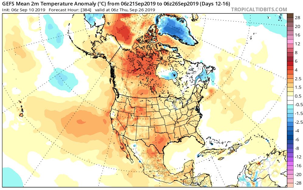
The only good thing I can see (model wise) about the next couple weeks, is that the NW US and SW Canada start to truly cool down after day 10. This will be our source for October cold (..hopefully frost/freezes).
-
Last year was bad as well. Looks like after this brief cool down, it'll stay hot into early October.
-

Looking Ahead to Fall and Winter
FallsLake replied to Iceagewhereartthou's topic in Southeastern States
for many of us Fall will start tonight (weather wise): .SHORT TERM /WEDNESDAY THROUGH WEDNESDAY NIGHT/... As of 128 AM Tuesday... The post-frontal stratocumulus/stratus should be mostly confined to the Piedmont Wednesday morning, then skies are expected to become partly to mostly sunny in all areas in the afternoon. A refreshing NE breeze will advect in much drier and cooler air. Expect highs only in the 70s, except a few lower 80s near the NC/SC border area. Then, mainly clear and cool Wednesday night. The most comfortable night in recent memory. Lows in the 50s, with some upper 40s north- central Piedmont. && -
Fall is normally beautiful here. If we're lucky we can get 4-6 weeks of open window weather.
-
We do get a break this week. from RAH: .LONG TERM /WEDNESDAY THROUGH SUNDAY/... As of 245 AM Monday... Much cooler and drier Wednesday through Friday, followed by a gradual warming trend over the weekend. High pressure is expected to extend into NC/SC from the north Wednesday through Friday. It will be much cooler and drier with very noticeable drops in both temperature and humidity expected. Sunny days and clear nights are forecast Wed-Fri, lows in the 50s. Highs in the mid 70s to around 80. The normally cool spots over the Piedmont will have some mid-upper 40s. The ridge aloft will build back into the region from the west over the weekend. This will allow the surface high to remain nearly stationary over our region Sat-Sun. A gradual warming trend will begin Saturday with highs in the 80s, after lows in the mid 50s to near 60. Highs Sunday should reach the upper 80s to around 90 with dry weather to continue. && **Those cooler spots are places like Sanford and Roxboro.
-
Definitely feel the difference this morning with the frontal passage. Cooler and overcast with a stiff NE wind. Still not the cool crisp dew points we're waiting for but a good break from the last couple of days.
-
Yeah, we're already getting temps in 80s/60s while we're in a bad pattern. In July this would be at least 90s/70s. Last year we started to see some foggy nights in mid/late September. We kept the higher dew point, and with the longer nights allowed the air to saturate. Looks like we might see more foggy nights this year...
-
-

Looking Ahead to Fall and Winter
FallsLake replied to Iceagewhereartthou's topic in Southeastern States
There was a lot of hype about a cold winter. Some of us did get lucky with the December storm, but otherwise it was a bad winter. -

Looking Ahead to Fall and Winter
FallsLake replied to Iceagewhereartthou's topic in Southeastern States
Looks like a pattern. Everybody has heard of the 30s heat (dust bowl), maybe we'll start dropping back in the coming years. **not considering climate change..... -
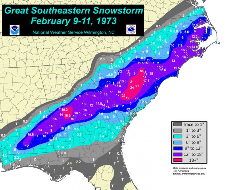
Lol, yeah I was just joking with NRVwxfan. He moved from Columbia to SW Virginia and is rightfully expecting to see more snow. But it would funny to see a couple of southern sliders this year like the one shown. **I've been saying for the last two years we're due to see one of these storms.
-
We also don't know about any feedbacks that may occur with more open water. Siberia (land mass) is still going to get very cold during the fall/winter months. When this air traverses over open water it will pick up moisture and then dump it as snow somewhere else. Most of the Arctic is considered a desert and increasing the winter snow accumulations will have an impact on the spring melt season; which in turn could slow the following years ice melt. **just agreeing with you that we don't know exactly how things will play out....
-
One thing that kills us in the SE during summer is the high humidity. Correlating with the high humidity are the high dew points that keep overnight lows warm. But in the next few days we'll (continue to) see an air mass that still has warm daytime temps in the 80s, but will have lows in the 50s to low 60s. That's bearable. From RAH: Shortwave ridging aloft and Canadian surface high pressure will build east across the cntl Appalachians and middle Atlantic states Thu and Thu night, with associated surface dewpoints and low temperatures in the 50s across the Piedmont, ranging to lwr 60s over the Sandhills and srn Coastal Plain. Highs near to slightly below average in the lwr to mid 80s, with very low/comfortable humidity levels.
-
Yep, we're going to have to wait and see how this evolves. Kind of fun having something to track.....Even if it is just cooler or wetter solutions.
-
RAH from last night: .LONG TERM /SATURDAY THROUGH WEDNESDAY/... As of 245 AM Thursday... An interesting pattern setting up for the long term period, starting with a cold front passage in the pre-dawn hours Saturday. Models generally agree this front will be located along the coast by 18Z Saturday; however, with the upper trough axis still to our west and SW flow aloft, this will promote overrunning of a shallow low level wedge of cooler and stable air that will move in from the north behind the aforementioned front. The end result will be a mostly cloudy, cooler, and potentially damp Saturday, esp east of the Triad, with rainfall amounts of a couple tenths of an inch possible in the post-frontal rain. Cooler too, with ample low cloudiness and rain. Meanwhile, it`s worth noting as mentioned in the latest TWOAT, the trough of low pressure located over the central Bahamas is progged by several models, including the latest ECMWF, to lift north and merge with the aforementioned cold front remnants off the SE coast on Sunday. Fortunately these models keep any low pres development well off the coast, but should this happen, central NC may actually benefit from this pattern by way of increased N/NE flow which would advect drier air into our area from the north. On the other hand, a front that stalls closer to the immediate coast would warrant PoPs across our eastern zones for Sunday. But the trends have tended to favor the drier option. Finally, such vigorous NE flow would keep temps below normal for daytime highs. That system will exit to our NE on Monday, with mainly dry weather continuing for our area. The next short wave will then approach from the west Monday night and Tuesday, with climo or higher PoPs needed for Tuesday and perhaps into Wednesday with the passage of this short wave. So we do want the low to develop and merge with the front; with (even more) cooler and dryer air being advected in.
-
That's how I ended my work down in Raleigh yesterday (...not romantic but dark). It really wasn't a big storm but it knocked out the power around 4pm near the US1/US401 split.
-
-
RAH now a little more optimistic that the front will push through our area this weekend. .LONG TERM /FRIDAY THROUGH WEDNESDAY/... As of 250 PM Wednesday... A cold front associated with an unseasonably strong northern stream trough/upper low passage through the NE US and Mid-Atlantic states will provide the focus for widespread showers and storms at the start of the period. The timing of this front through the area continues to be a source of large model spread and high forecast uncertainty. General timing brings the cold front into the area from the NW late Friday afternoon and will slip slowly south through the overnight, before finally settling south of the area on Saturday. Low-level frontal convergence underneath the right entrance region of a ~90 kt upper jet streak associated with the upper trough moving through the region will result in deep/strong ascent across the area. Precipitable waters of 2.0-2.25", MLCAPE ~2000 J/Kg and a belt of strong westerlies of 30 to 35 kts dropping south into the area will support the threat for organized strong to severe storms, along with the threat of heavy rainfall of 1 to 2 inches with localized flash flooding possible Friday afternoon and evening. If latest model trends verify, a shallow of wedge of cooler and stable air will advect south through the day on Saturday as the cold front progresses south into SC and GA. While convection should follow the front, models suggest a a period of ana-frontal precip lingering across at least southern portions of the forecast area INVOF of the h8 trough axis Saturday afternoon and evening, possibly lingering into Saturday night. As the cooler and drier continues to filter into the area from the north Saturday night and into Sunday, courtesy of a strong ~1030 parent sfc high over New England, rain chances should decrease, leaving behind primarily cloudy and cool conditions Sunday and Monday. Rain chances return as early as Tuesday and Wednesday with the approach of a shortwave trough from the WSW. Finally, the NHC is monitoring an area of disturbed weather located over the central and northwestern Bahamas. Some slow development of this system is possible with a low-20% chance of becoming a tropical cyclone over the next several days. As such, it is incredibly too early to forecast what impacts, if any, are possible across central NC. Make sure you follow a trusted weather source for all of your weather information.
-
-
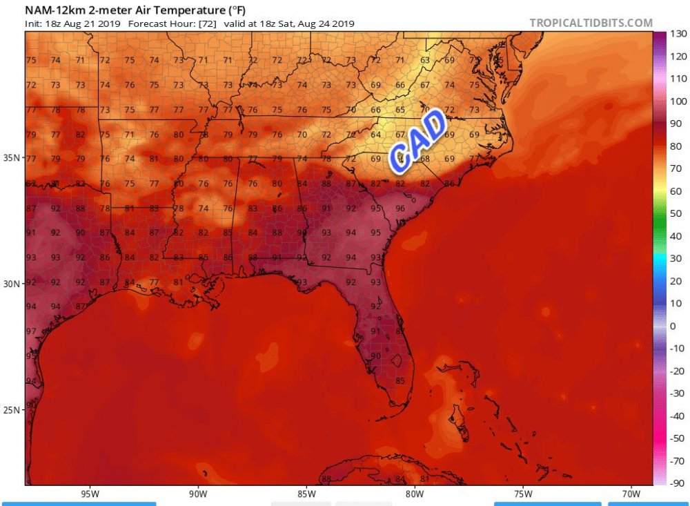
Rah still on board for a weekend cool down, but they are leaning towards the euro for the details. <last two paragraphs of the extended discussion> Thursday night into Friday the upper level low will rotate east towards Quebec with another shortwave diving southeast out of Ontario on the backside. The GFS is slightly more amplified with this secondary wave compared to the ECMWF, while the CMC wraps this secondary energy up and actually holds it back a bit. The GFS solution pushes a cold front into central North Carlina Friday afternoon and has the front clearing North Carolina Saturday. The ECMWF and CMC are not this optimistic. The ECMWF stalls the front over central North Carolina while the CMC washes the front out near the Coastal Plain. Looking at the GEFS also reveals that the deterministic run is optimistic compared to the GEFS mean regarding drying conditions. The overall trend for the forecast was towards the ECMWF/ CMC and GEFS mean. This means widespread coverage is likely starting late Friday evening into Saturday as a cold front oozes south through the area. PWATs ahead of the front are forecast to be around 2.1", or near max values for this time of year. Warm cloud depths are also forecast to be above 12.5 kft at times which will help to maximize warm rain processes. Saturday afternoon the ECMWF, EPS mean, CMC,and GEPS mean show continued widespread coverage. The GFS at this time is dry having the front down towards South Carolina. As mentioned above, have kept towards the CMC and ECMWF here and raised PoPs for Saturday. The other trend for Friday and Saturday has been to nudge temperatures down. Given widespread convection forecast and a cold front oozing south think temperatures will be below normal for this time of year. Sunday the CMC and ECMWF show continued widespread coverage as the front stall across southern North Carolina and multiple mid-level impulses ride east along the baroclinic zone. Temperatures Sunday into Monday will likely remain below normal with a potential weak CAD developing.


