FallsLake
-
Posts
6,318 -
Joined
-
Last visited
Content Type
Profiles
Blogs
Forums
American Weather
Media Demo
Store
Gallery
Everything posted by FallsLake
-
From what all the mets have said and what the LR models show, it does look like most of January is toast. Of course we'll get a few cold fronts to come through and some locations in the mountains may see some light events (like yesterday); but it's going to be a warm pattern for at least a couple of weeks. Now a little positive attitude, I still think we have at least a 50/50 chance of getting into a better (if not great) pattern. Fab February could be coming. Couple of points: 1) All the indices are bad, but as said before what comes up must come down (question is when). 2) We've got locked into a stable pattern. Once we get into February/March (usually) the global stable winter patterns begin to fluctuate with smaller troughs and ridges. No guarantees, but at least we can get (quick) eastern troughs again. 3) The northern hemisphere has had cold. It's been locked up in western Canada. If/when we get a flip, it should not take long (days) to get us very cold. So basically it could end up being the worse winter ever, Or it could end up being a great winter, or something in between.
-
12z GFS is showing a quicker return of cold in the LR. The below image is for the 15th. It shows the cold (2m temps) pouring in; but what I like is it also shows the effects of the mountains (always slows our low level cold).
-
I would put my location (right on the Granville/Wake line) at or greater than 5 feet from 2010 until now. I've been lucky and received big storms whereas folks in south Wake have missed out.
-
Man, January is not looking good. Most LR models / indices give us little hope through mid month. I hate having access to the CFS model on the Pivotal site. It would indicate all of January is toast; and if you extrapolated, at least the first week of February is lost. But I (we) should know it'll show a different solution within the next few runs (hopefully). https://www.pivotalweather.com/model.php?m=cfs&p=prateptype_cat&rh=2020010106&fh=6&r=conus&dpdt=&mc=
-
You really don't want to look at the CFS. But, if you do (day 24 2m temp anomaly): https://www.pivotalweather.com/model.php?m=cfs&p=sfct_anom&rh=2019123112&fh=564&r=na&dpdt=&mc=
-
I keep thinking what goes up must come down (and vice versa). So with all the indices current in an unfavorable state, you would think a strong reversal is in order at the end of this month. Also, I've read that in cold winters there is usually a mid winter thaw (a relaxing of the predominate pattern). This also applies to warm winters where a mid winter cold period usually occurs. If I'm correct, I think 2000 was an overall warm winter and we ended up getting this (at mid winter):
-
Yeah, we've seen many years where our first storm comes at the end of January; and then many more where (Fab)February saves us. I wasn't worried going up to Christmas (December usually doesn't produce anyways), but I would be lying by saying I wasn't worried about losing most of January.
-
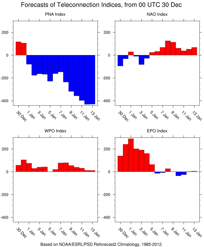
The indices today still look terrible. PNA - Still looks to go negative AO/NAO - Stays strongly positive EPO - Stays positive https://www.cpc.ncep.noaa.gov/products/precip/CWlink/daily_ao_index/teleconnections.shtml Hopefully things turn around at the end of this month.
-
It's good to have you back! You still in Apex?
-
Yep, we had a Halloween storm (..at least I did) and then the cold first 2/3 of November. It flipped warm in December and now is having a hard time flipping back cold. Sometimes Fab February can save us, but no guarantees.....
-
Of course I'm hoping for the 12z model runs to show an epic SE snowstorm. But, I'm actually thinking they'll show warmer solutions in the LR. Looking at the indices, it doesn't look good. PNA looks to go strongly negative **I've always considered this the most crucial EPO looks to get down to neutral **it was showing negative NAO looks to be positive **as always.

-
Merry Christmas everybody!! I hope you all have happiness and good health for the new year. And we all score a big dog storm......
-
Of course I'll always wish for wintery precip over any other weather feature, but I would love to see an old fashion Siberian Express arctic airmass. We had the one a couple of years back but nothing really substantial last year. I love sunny days below freezing and seeing the lake freeze over.
-
Man, the CFS says we could be in for a wild ride the next few weeks. https://www.pivotalweather.com/model.php?m=cfs&p=prateptype_cat&rh=2019120500&fh=12&r=conus&dpdt=&mc= Start from beginning and go to the end. Lots of potential storms (especially for central NC northward).
-
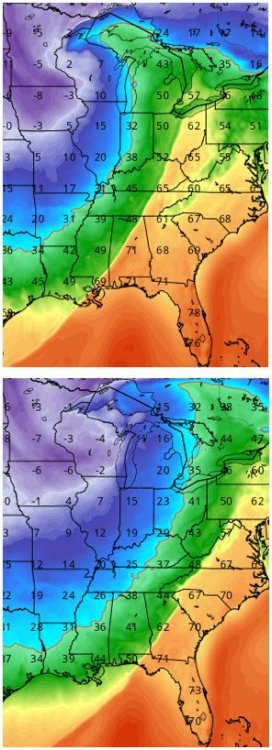
Funny/interesting what RAH said in their Short Term discussion last night: .SHORT TERM /THURSDAY AND THURSDAY NIGHT/... As of 215 AM Wednesday... 1035+ mb surface high pressure is expected to build across the eastern states from Ontario and the Great Lakes states Thursday and Thursday night. CAA will send the temperatures below normal for Thursday and Thursday night. Expect highs 5-10 degrees below normal with highs most likely skewed toward the colder MET/EC statistical guidance. The GFS appears too warm. Expect mostly mid to upper 50s north and lower 60s south with mostly sunny skies. Expect mainly clear and cold conditions Thursday night with lows in the upper 20s to mid 30s. Throw out the GFS MOS! It is too warm, again. &&
-
Just hoping they hold off until after 8pm. WRAL is concerned about pop-up storms before the main band.
-
Unfortunately, somebody is going to get the strong storms during the prime trick or treating time. Being selfish for the RDU area, it looks like we may be good with the main band coming in closer to mid-night (per current models and what B.Panovich stated above). WRAL also seems to think this will be the scenario, but RAH is much more vague and even has "Likely" precip starting at ~6pm for my grid location.
-
That's truly sad. It seems there have been a lot more deaths this year attributed to rip currents.
-
I like seeing that region (and up into SW Canada) get early snow. That's were some of our cold will come from later in the season.
-
Last year was bad as well. Looks like after this brief cool down, it'll stay hot into early October.
-
Lol, yeah I was just joking with NRVwxfan. He moved from Columbia to SW Virginia and is rightfully expecting to see more snow. But it would funny to see a couple of southern sliders this year like the one shown. **I've been saying for the last two years we're due to see one of these storms.
-
We also don't know about any feedbacks that may occur with more open water. Siberia (land mass) is still going to get very cold during the fall/winter months. When this air traverses over open water it will pick up moisture and then dump it as snow somewhere else. Most of the Arctic is considered a desert and increasing the winter snow accumulations will have an impact on the spring melt season; which in turn could slow the following years ice melt. **just agreeing with you that we don't know exactly how things will play out....
-
That's how I ended my work down in Raleigh yesterday (...not romantic but dark). It really wasn't a big storm but it knocked out the power around 4pm near the US1/US401 split.
-
I've heard this winter we're going to get storm after storm that follows this path:
-
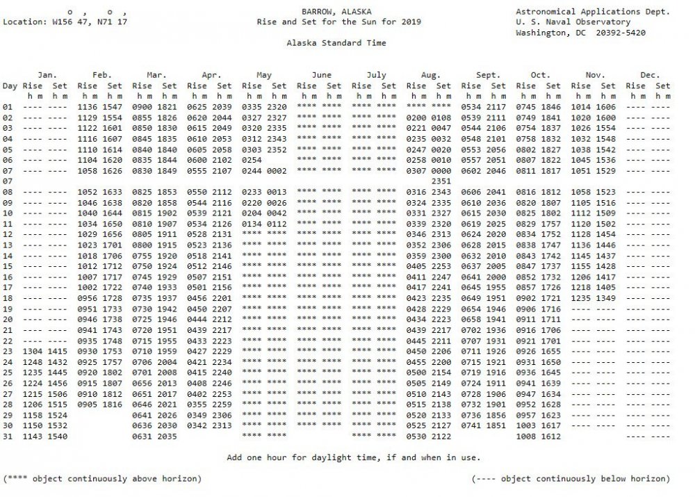
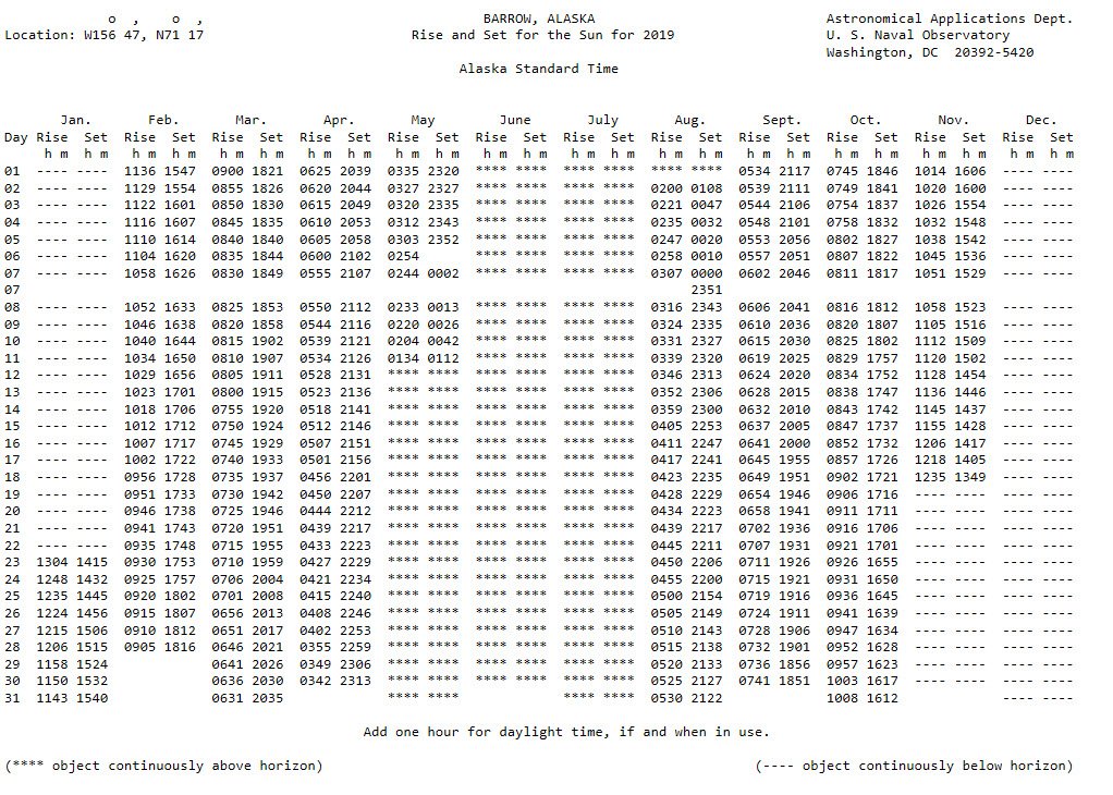
Here's something small to celebrate; the sun sets at Barrow Alaska tonight (first time since spring).