Sydney Claridge
-
Posts
537 -
Joined
-
Last visited
Content Type
Profiles
Blogs
Forums
American Weather
Media Demo
Store
Gallery
Everything posted by Sydney Claridge
-
I’m getting concerned about the path this storm is taking. It’s moving in the direction of the Lansing metro area (especially the SE part). If this storm can hold together, there would be concern for a tornado in a highly-populated area.
-

Severe Weather May 17th 2021
Sydney Claridge replied to weatherextreme's topic in Central/Western States
And just look at how wrapped up that hook echo is. Looks great on radar, but I sure wouldn’t want to be in the path. EDIT: it now has a PDS tornado warning on it. Large and extremely dangerous tornado in progress, fortunately this is happening in an area with very low population.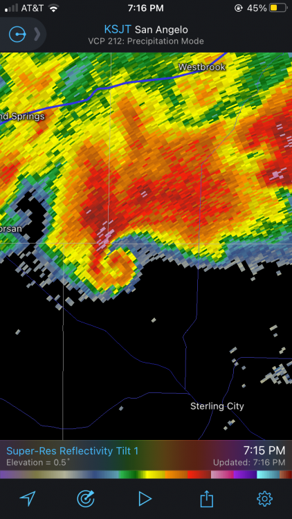
-
Severe Weather May 17th 2021
Sydney Claridge replied to weatherextreme's topic in Central/Western States
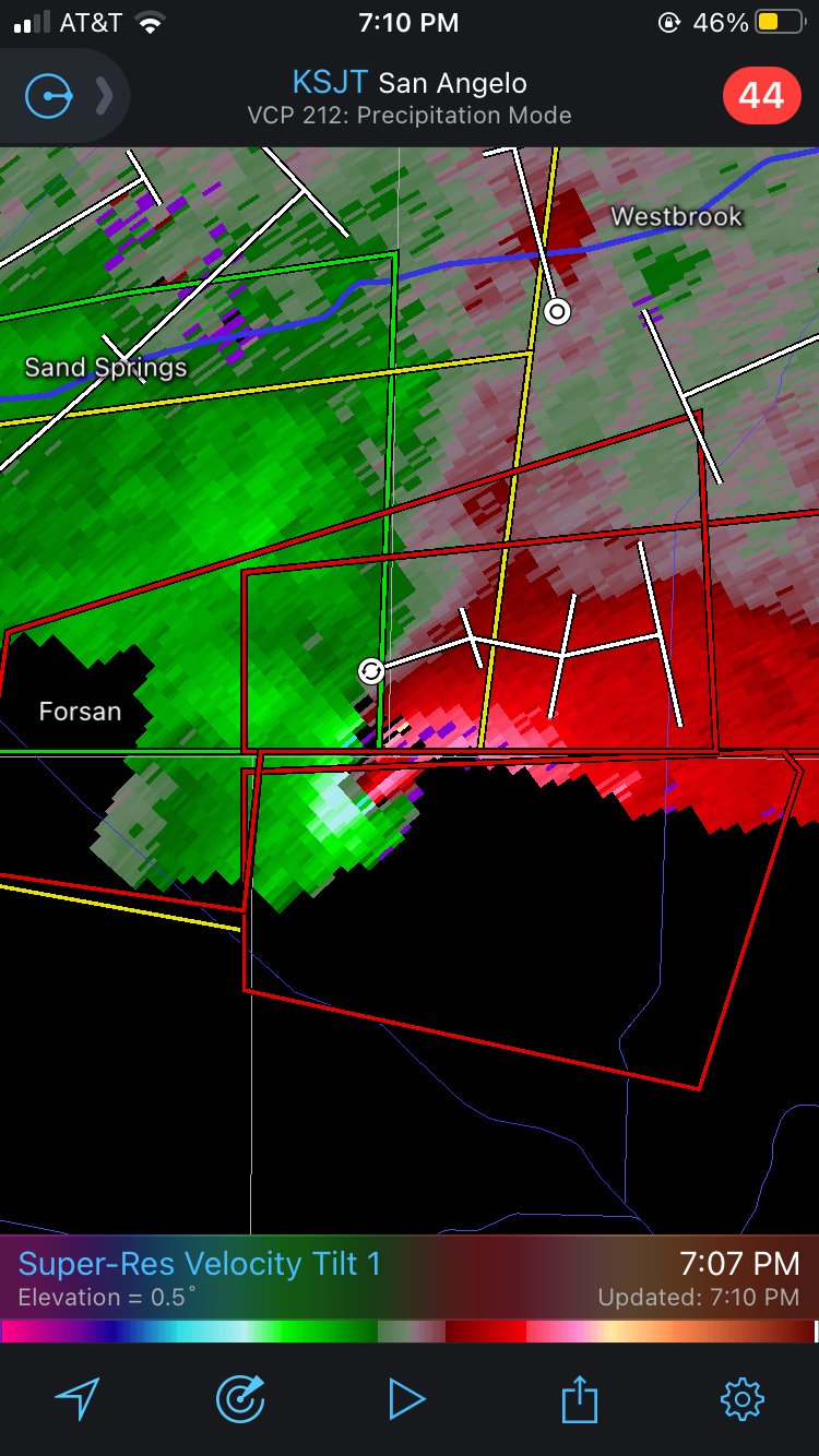
Looked like a pretty well-developed rotational signature in NW Sterling County, TX, SE of Forsan:
-
General severe weather discussion
Sydney Claridge replied to Quincy's topic in Central/Western States
Looks like a hail core has formed with a left-mover SE of Springtown, TX and is moving in the direction of Azle. Tarrant County may need a severe thunderstorm warning soon if so. The main supercell continues to move SSE towards Weatherford. -
General severe weather discussion
Sydney Claridge replied to Quincy's topic in Central/Western States
It looks like some pretty serious damage occurred to a home in the Northhaven area. Some debris was even lodged into the ground, apparently: https://mobile.twitter.com/HowertonNews/status/1394032811875651595?ref_src=twsrc^google|twcamp^serp|twgr^tweet We’ll have to wait for the official survey, but the evidence seems pretty convincing for a brief tornado touchdown. This very spot got hit with the tornado on 10/20/19, so if this were a tornado it would be the second time in less than two years that a tornado hit this spot. -
General severe weather discussion
Sydney Claridge replied to Quincy's topic in Central/Western States
Apparently there was "significant tree damage" at Goar Park in University Park according to NWS storm reports. Also a home got damaged on Northhaven Road across from North Haven Gardens, which was an area hit hard back on October 20, 2019. -
Severe Weather May 3rd 2021
Sydney Claridge replied to weatherextreme's topic in Central/Western States
That now-severe storm northeast of Denton seemed to blow up out of nowhere. Though very minor right now, radar seems to suggest additional attempts at initiation SW of Decatur. -
Severe Weather May 3rd 2021
Sydney Claridge replied to weatherextreme's topic in Central/Western States
Storm northeast of Denton (around Pilot Point) might need a warning soon; it seems hail sizes are coming up. Also there seems to be a notch on that storm over Mesquite. Fortunately it seems there is very little rotation however. -
Severe Weather May 3rd 2021
Sydney Claridge replied to weatherextreme's topic in Central/Western States
Yep, couplet on radar: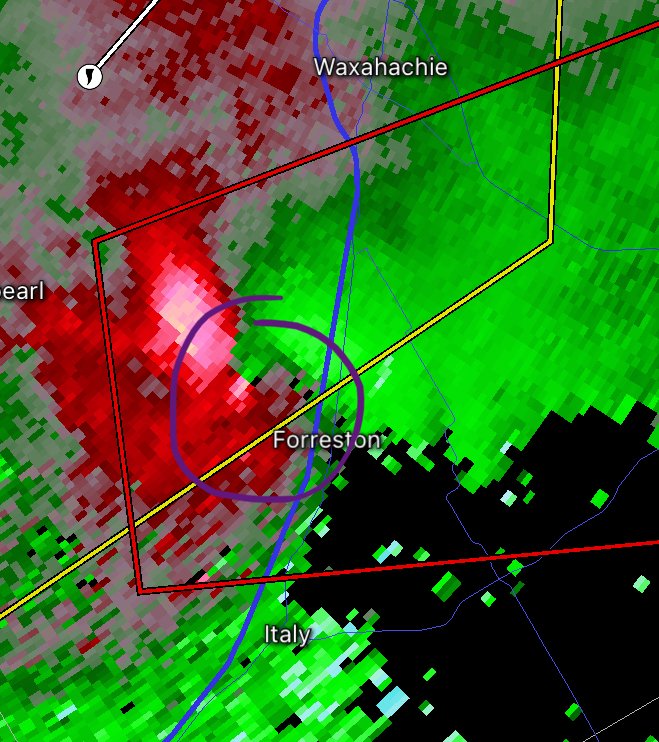
-
Severe Weather April 27-28th 2021
Sydney Claridge replied to cheese007's topic in Central/Western States
New TOR warning includes NE San Antonio metro area and New Braunfels. Seems to be some strong winds in that storm with perhaps some rain-wrapped rotation (though it seems broad). That said, the below screenshot doesn’t really seem to show rotation and seems to be a straight-line wind threat.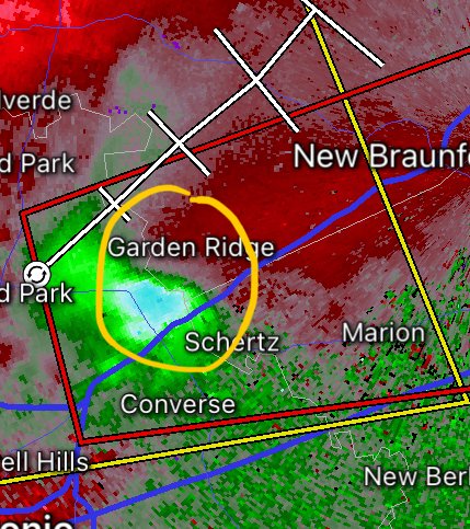
-
Severe Weather April 6th-10th 2021
Sydney Claridge replied to cheese007's topic in Central/Western States
What I saw driving home from work had quite a high base; I wonder if this updraft is rooted above the cap? -
Spring/Summer 2021 Banter/Complaint Thread
Sydney Claridge replied to madwx's topic in Lakes/Ohio Valley
It’s crazy to see such cold temperatures there so late, although definitely not unprecedented as their April record low is -32F. Climatically speaking, Fairbanks has very little seasonal lag. This means that in Fairbanks, June is warmer than August, and December is colder than February. It looks like temperatures return to normal next week, and that streak of below 40F temperatures will come to an end. -
Severe Event March 25th 2021
Sydney Claridge replied to Bob's Burgers's topic in Southeastern States
Speaking of Atlanta, if this storm can hold together that long, it might try to make a run at the southern portion of the Atlanta metro area. That would be very concerning. -
General severe weather discussion
Sydney Claridge replied to Quincy's topic in Central/Western States
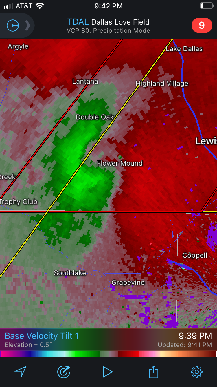
Looks like some rotation is tightening up pretty quickly around Flower Mound.
-
General severe weather discussion
Sydney Claridge replied to Quincy's topic in Central/Western States
I'm going to get more concerned for a severe storm threat here in the Metroplex if the dewpoints can continue to rise into the 60s. The southern and eastern sections have already seen this happen, and there is additional storm activity forming to the west as well (between DFW and Abilene, but those storms appear to be elevated and behind the surface front). -
Severe Event March 25th 2021
Sydney Claridge replied to Bob's Burgers's topic in Southeastern States
Given that several models show intensification of the low pressure over Illinois and Indiana (eg. GFS, Euro, 0z HRRR), I would definitely agree with that sentiment, if primarily out of concern for damaging straight-line winds (and while not related to SPC criteria, perhaps for non-thunderstorm winds too, especially in IN/OH, in the event of a particularly-strong low). Some of these models also have lower-60s dew points getting north of the Ohio River, even as far north as the I-70 corridor (Indianapolis-Dayton-Columbus) in some runs. SPC even hinted at QLCS potential for the Ohio Valley (KY/IN/OH) as well. If more destabilization and warmer temperatures/dews (than what models currently show) can get that far north, I would be concerned for a more widespread severe thunderstorm outbreak than what is currently expected. It appears as if that all comes down to the amount of "junk" precipitation that forms, as less would mean more supercell (and tornado) potential and potentially a greater spatial extent to any potential outbreak. If things stay "junky," then whatever tornado potential remains might appear confined to MS/AL, but less junk would increase potential in MS/AL plus bring more severe storm action into the TN and OH valleys. -
March 17-18 Severe Weather Event
Sydney Claridge replied to DanLarsen34's topic in Southeastern States
There was definitely a lot of tornado potential today that was (fortunately) not realized. Definitely there were a few strong tornadoes, but the ceiling was a lot higher. If today counts as a bust, then it reminds me a little bit (but for different reasons) of May 20, 2019, which also had a 45% hatched tornado risk, but outside of one or two supercells, was a bust. Tornado season is only just starting. I’m still concerned about the potential for one (or more) significant tornado outbreaks later this spring. -
Severe Weather 3/12-3/15
Sydney Claridge replied to Tallis Rockwell's topic in Central/Western States
Interestingly surface temperatures seem a bit cool in that area, but higher elevations don't need the same temperatures and dewpoints as lower elevations to get the same amount of SBCAPE, either. Temperatures on the SE side of that storm are in the mid-to-upper 50s, but it seems like 40s are closer to the storm. -
Severe Weather 3/12-3/15
Sydney Claridge replied to Tallis Rockwell's topic in Central/Western States
We have a MDT for 15% hatched tornado probabilities now. I think this is the first MDT of 2021 so far (I might be mistaken though). Seems like tornado season is starting to ramp up, especially if that MDT verifies. -
Severe Weather 3/12-3/15
Sydney Claridge replied to Tallis Rockwell's topic in Central/Western States
That is exactly what worries me about this tornado season. Once things start to ramp up I am concerned that we will have some dangerous tornado outbreaks. I highly doubt we will have a tornado season as extreme as 2011, given that 2011 was essentially a “worst-case” scenario, but you can never rule that out, either. A more “tame” severe weather event (no severe storm is “tame” though), such as what might happen this upcoming weekend, might help get people into the mindset of severe weather preparedness and away from complacency, before the truly dangerous stuff comes along. -
I agree. The public at large needs straightforward messaging that helps them best understand what the hazard(s) are. The government does not (and should not) expect everyone to understand the technical terminology used in severe weather warnings, watches, or advisories. I'm a weather hobbyist who understands some of this terminology, but my formal college education is in the social sciences. So much focus is on the difference between a watch (be prepared for the hazard) and a warning (take appropriate action). My understanding is that advisories refer to hazards that are below "severe" criteria (eg. winter, thunderstorm, flood, etc.). If there is a more effective way to communicate that to the public, then that is what should be done.
-
On the Day 3 outlook, SPC removed all mention of severe thunderstorm potential for Sunday. Seems like those uncertainties might have won out.
-
Aside from a few warnings here and there, this was a complete bust. There were no severe weather reports at all per SPC (at the time of this post), quite surprising for a day that started out with an Enhanced risk (and a 10% tornado contour), albeit this was later downgraded.
-
Spring 2020 was interesting, with a particularly intense period in April, but tornadic activity dropped off pretty quickly after that, with a quiet autumn to boot. I'm going to assume that 2021 could be an intense season, with a La Niña currently in place. I know that a transitioning La Niña favors an uptick in tornadic activity in the Southern Plains (Texas-Oklahoma), but that Dixie Alley and the Ohio Valley often see increased activity in cases of a resurgent La Niña (see "US regional tornado outbreaks and their links to spring ENSO phases and North Atlantic SST variability" by Lee et al.). Forecast precipitation anomalies seem to show increased precipitation in the Ohio Valley in particular. I'm going to place my bets on an active 2021 season for Dixie Alley and the Ohio Valley.
-
There’s quite the temperature divide across the Houston metro this morning, with 50s in the far west suburbs (Katy), with 40s not too much further west, but generally upper 60s over the rest of the metro. Definitely cannot rule out severe storms in the Houston area until the front passes through (which it should do in the next few hours as the storm system moves NE). The storm coming ashore at Surfside Beach looks slightly isolated and now has a severe thunderstorm warning with “tornado possible” wording indicated.