Sydney Claridge
-
Posts
532 -
Joined
-
Last visited
Content Type
Profiles
Blogs
Forums
American Weather
Media Demo
Store
Gallery
Everything posted by Sydney Claridge
-
I knew southern Tennessee was within the outbreak area on 4/27/2011 (the afternoon and evening storms were especially intense in SE TN), and was aware that the morning convection did result in multiple tornado touchdowns. But notice the relative lack of severe storm reports from western TN up through OH, all areas that were in the Day 2 Moderate risk. It is these areas I was saying had their severe storm potential suppressed (but not completely so, given some wind/isolated tornado reports particularly in KY/OH) by earlier convection. I cited the Day 2 outlook from April 26, 2011 to highlight some of the concerns SPC had then with issuing a Day 2 High Risk.
-

Easter Weekend Severe Thread
Sydney Claridge replied to janetjanet998's topic in Central/Western States
It looks as if there is some convective initiation starting immediately north of Abilene, TX. Some additional areas of potential initiation also seem apparent on radar SE of there and over the Hill Country. I will be closely watching to see how widespread any convection can become. -
The CIPS Analogs now place 4/27/2011 as the 3rd best analog. 3/1/2007 (day of the Enterprise tornado) is the 2nd best analog; previous analog runs have consistently placed the 3/1 outbreak near the top. Even as one of the top analogs, it does not mean this this potential tornado outbreak will be like 4/27/11, but the fact that this is showing up so high in the analog list gives us an idea what the worst-case scenario for tomorrow could be. SPC held off on a Day 2 High Risk for 4/27/11 as well, citing concerns about morning convection, although the Day 2 Moderate went all the way up into Ohio (and as we know, that morning convection, although quite severe itself, did seem to suppress severe storms from western TN northwards and kept those northern areas from suffering an outbreak like 4/3/1974). Just because something is the worst-case scenario does not mean it will actually occur. But emergency management, hospitals, and public health authorities need to be ready for that worst-case scenario, especially when the risks for displaced and/or injured people involve more than just losing a home or having injuries treated at a hospital; the ongoing COVID-19 pandemic means that there is very real risk that any displaced and/or injured individuals could catch and/or spread the virus. And as previously mentioned, even sheltering from a tornado in a public shelter could pose some concerns with respect to viral spread. Even if this winds up not being a widespread tornado outbreak, it takes only one tornado going through a highly-populated area (and I mean anything from a moderately-sized city like Meridian MS all the way up to a major metropolitan area like Birmingham) to make these concerns real. While absolutely devastating to the people living there, a tornado strike on a rural area or smaller town should be much more manageable for emergency management, hospitals, and public health authorities, provided that there is adequate hospital coverage and availability (that said, this can be an issue in parts of the South).
-
Easter Weekend Severe Thread
Sydney Claridge replied to janetjanet998's topic in Central/Western States
The looming question for myself and others in north-central Texas is whether convection will evolve to the west and create a cold pool over the area today. Several models are now suggesting that this will not happen; out of the five CAMs available on the Pivotal Weather website only the NAM3k is going with a cold-pool solution. Those other CAMs get the DFW Metroplex into a moist, unstable atmosphere from about 1pm (18z) onwards. The NAM3k had convection going up around Midland at about this time, but observations show that this has not happened yet. I will definitely be watching how widespread any convection to the west may develop this morning. If a cold pool fails to develop and the afternoon temperatures get well into the 70s, then I would not be surprised if a more substantial severe weather threat evolves in my area later today. -
Easter Weekend Severe Thread
Sydney Claridge replied to janetjanet998's topic in Central/Western States
All I can say is that with the ongoing COVID-19 pandemic, emergency managers, hospitals, and public health authorities need to have a plan for how they are going to deal with the displaced and injured, especially should a strong-to-violent tornado strike a well-populated area in the coming days. That grim outcome is definitely a possibility, though not a certainty by any means. Keep in mind that anyone who is displaced or injured would be at a greater risk for catching (or spreading) COVID-19. I have not heard too much about overburdened hospitals in the South outside of New Orleans (and even they are in the risk area here, though the most severe activity should be to the north of them), but this potential tornado outbreak could not be coming at a worse time. While tracking storms can be exciting, the death, displacement, and destruction they cause are anything but exciting. Honestly I hope this busts completely, but the signals are there for a potential tornado outbreak. -
Easter Weekend Severe Thread
Sydney Claridge replied to janetjanet998's topic in Central/Western States
Long story short, just to rehash that discussion, it basically says that we need to watch the evolution of that storm activity currently out by Midland and Lubbock. If said activity evolves into an MCS and persists as it moves eastwards into north-central Texas and Oklahoma (which seems to be the most likely scenario), then that convective activity will leave behind a cold pool, cutting off severe weather potential and N TX and OK. That HRRR run has the Midland/Lubbock activity fall apart and fail to grow upscale into an MCS. -
Sounds about right. That line near the Mississippi River would probably go linear, but I doubt you could rule out tornadic supercells there either if that 12z NAM run is correct (with higher EHI in that area), and even if linear, QLCS tornadoes and embedded supercells could pose a danger. But the most violent activity would have to be with any supercells ahead of this line.
-
That would be a very scary situation anywhere from Louisiana to Alabama, but particularly across northern Mississippi, if that run verifies. I still have some questions about the extent of precipitation, but with the level of shear and helicity depicted, any area of warm-sector precipitation could be at risk of turning supercellular and tornadic. This NAM run also shows an area of precipitation ahead of the main line (that is at the western edge of the 70F+ dewpoints) in E Mississippi and SE Louisiana, and I have little doubt that those storms could also turn tornadic. Let's just hope that any tornadoes avoid highly-populated areas. Given the COVID-19 pandemic, people that lose homes will need places to stay in the aftermath of a tornado, so they do not risk contracting COVID-19 (or contribute to its spread if they already have the virus); this is much more manageable if the tornadoes can stick to rural areas and avoid population centers, unfortunately the South is more densely populated than the Plains, so the odds are higher that a population center could get hit. Hospitals are already burdened in some places by COVID-19 (particularly around New Orleans, though the worst of the severe weather should stay north of there), and the U.S. South is at particular risk of people developing serious complications, given that more people living there have preexisting medical conditions such as heart disease and diabetes. Having a major tornado outbreak occur amongst this pandemic is one of my worst fears, especially should at least one of those tornadoes strike a major population center. Needless to say I am hoping that this busts completely, but there could be a tornado outbreak this Sunday.
-
Apr. 6-8 Severe Risks
Sydney Claridge replied to Tim from Springfield (IL)'s topic in Lakes/Ohio Valley
Hopefully this storm starts to weaken before it hits Memphis, but it is in a highly unstable environment. SRH is not the highest (but is forecast to increase), but the CAPE more than makes up for that and allows for fairly high EHI values. EDIT: rotation seems to have become less organized but the storm is probably cycling. EDIT 2: the tornado warning has been dropped. If this storm is cycling, however, rotation could easily ramp up again at any time. -
Apr. 6-8 Severe Risks
Sydney Claridge replied to Tim from Springfield (IL)'s topic in Lakes/Ohio Valley
The storm south of Jonesboro has a confirmed tornado on it as well. While forward motion is fairly slow (25mph), the storm may try to move towards the Memphis area if it holds together for that long. -
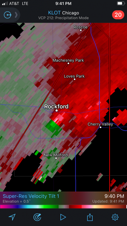
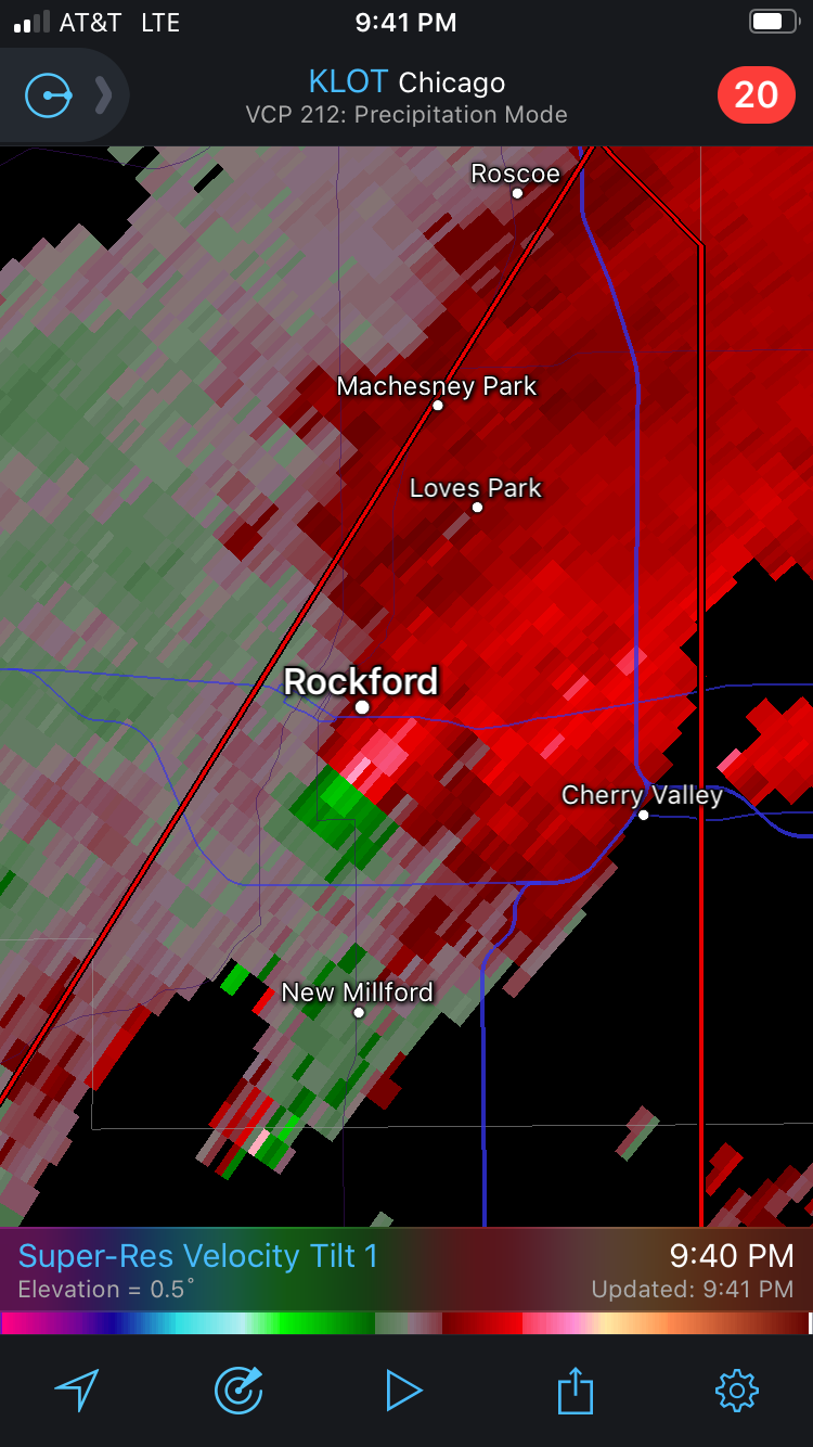
Apr. 6-8 Severe Risks
Sydney Claridge replied to Tim from Springfield (IL)'s topic in Lakes/Ohio Valley
Not necessarily pertinent to this subforum, but this storm over northern West Virginia looks pretty vicious right now. It is not that often that you see a storm like this over this region:
-
Apr. 6-8 Severe Risks
Sydney Claridge replied to Tim from Springfield (IL)'s topic in Lakes/Ohio Valley
West Bend and Port Washington, WI are now under a severe thunderstorm warning. Surface-based activity could be possible I guess, given the proximity of the warm front and plentiful SBCAPE, but it won't be too much longer before this storm goes over Lake Michigan (and becomes elevated as a result). West Bend, WI seems to be reporting 73 degrees as well. Port Washington is at 54 degrees, so the storm will have to become elevated just before it reaches the lakeshore I guess; there may be a lake-breeze boundary near I-43 around Grafton given temperature differentials there. Further south, the warm air is reaching all the way to the lakeshore. EDIT: I'm also watching that hook near Jackson, WI as well. It does not look to be anything too concerning at the moment (it seems to be broad/weak rotation). EDIT 2: another severe thunderstorm warning has gone up in southeastern Ohio as well, with a storm approaching the I-77 corridor. -
Apr. 6-8 Severe Risks
Sydney Claridge replied to Tim from Springfield (IL)'s topic in Lakes/Ohio Valley
And so it looks like things are starting to ramp up. Shouldn't be too long before it goes severe at this rate. Temperatures just to the south are in the mid-70s, although the prior poster said storms are just north of the warm front. -
Apr. 6-8 Severe Risks
Sydney Claridge replied to Tim from Springfield (IL)'s topic in Lakes/Ohio Valley
SPC has now introduced a 5% tornado risk in the vicinity of the tri-point of MI/IN/OH. 15% hatched hail risk now extends northwest to Chicago, although areas further south (like Cincinnati and Indianapolis) have been removed from the hatched risk. -
Apr. 6-8 Severe Risks
Sydney Claridge replied to Tim from Springfield (IL)'s topic in Lakes/Ohio Valley
Completely agreed, those surface winds are pretty weak so even getting a brief spin-up is going to be hard, and any such thing would have to be confined to the boundary itself given that LCL heights are pretty high just to the SW and temps are pretty cool just to the NE. The main action will likely be with any activity that forms further northwest later on, particularly in northern IN and southern lower MI (and maybe northern IL though SPC has backed off on that; likely NW OH too). -
Apr. 6-8 Severe Risks
Sydney Claridge replied to Tim from Springfield (IL)'s topic in Lakes/Ohio Valley
The boundary I mentioned in my prior post is quite evident on the 10z HRRR, extending from near Columbus OH to near Clarksburg WV. The HRRR shows convective initiation in central OH (NW of Columbus) around this same time. The model shows backed winds along this boundary (in some areas they are coming out of the south, although other models back the winds less). There could be a window for a tornado or two if this verifies, provided convective initiation occurs and remains discrete (10z HRRR shows a few likely supercells in SE OH shortly after this), although T/Td spreads are quite large on the SW side of the boundary.
-
Apr. 6-8 Severe Risks
Sydney Claridge replied to Tim from Springfield (IL)'s topic in Lakes/Ohio Valley
Several of the CAMs have been consistently sending up isolated storms (some of which seem to grow into supercells) in the wake of the morning convection over central and southern Ohio in the afternoon hours. The 06z NAM3K has also moved closer to the HRRR and seems to initiate a supercell in southeastern Ohio. Although not a CAM, the RAP has also consistently suggested "popcorn" precipitation (possible storm cells?) developing in Ohio at the same general time. I am wondering if all of those models think that the morning convection will leave some sort of boundary behind? While parameters seem better further northwest, the storms there seem to develop more readily into clusters, so if this verifies, portions of Ohio could become a focal point for significant hail and *possible* tornadic activity (the direction of the surface winds near this boundary will be a factor, if they are coming out of the SW rather than the W then isolated tornadoes could be an issue). The HRRR suggests that the timeframe for this isolated convection to form would be around 18z near the Columbus area, and it is definitely conditional on the amount of subsidence and capping that is in place in the wake of the morning convection. I do think that northern IN/OH and southern lower MI may be biggest risk areas for severe storms, although a diagonal strip from southern WI all the way the Delmarva will need to be watched. -
Apr. 6-8 Severe Risks
Sydney Claridge replied to Tim from Springfield (IL)'s topic in Lakes/Ohio Valley
Yikes, the 21z RAP is putting out high EHI values (and PDS TOR forecast soundings) near Chicago, and then over into northern IN and SW MI, with some precipitation in the area. Probably overdone, but maybe that risk area does need to be shifted NW a little bit, considering that several models are putting northern Illinois in an area of severe storm risk? -
Apr. 6-8 Severe Risks
Sydney Claridge replied to Tim from Springfield (IL)'s topic in Lakes/Ohio Valley
Another point of note: observations of dew points in most of northern Ohio are in the mid-to-upper 20s right now (although dewpoints are about 50 down by Cincinnati). Today's 12z and 18z HRRR runs show northern Ohio to be a possible area for (potential?) surface-based convection tomorrow afternoon, and I am having trouble believing this scenario given how dry the surface airmass currently is. That said, SPC has said this would be an area of subsidence following the morning convection. 18z NAM3K puts 60s dewpoints in place across all of Illinois, Indiana, and most of Ohio (except the NE corner). Both 18z NAM3K and NAM runs would be more favorable for isolated tornadoes given lesser T/Td spreads relative to HRRR runs (although HRRR does show more convective activity, it also shows more mixing and thus larger T/Td spreads). -
Central/Western Medium-Long Range Discussion
Sydney Claridge replied to andyhb's topic in Central/Western States
With the COVID-19 pandemic and all, getting a major tornado outbreak (or just one major tornado striking a populated area) would be horrific, especially once you consider the need for hospital beds for both the injured and COVID-19 patients. It would be much more manageable if the tornadoes stuck to rural areas, but that is never a guarantee; just look at what happened back in 2011. Something like the 2011 Joplin tornado (which destroyed a hospital), if it occurred today, would be a lot worse given the current pandemic. A quiet pattern is a much needed reprieve right now, and hopefully we don't have to worry too much about severe thunderstorms and tornadoes until COVID-19 quiets down somewhat. But you never know, especially considering that we are now in the most active time of year for severe thunderstorms and tornadoes (April/May/June). -
2020 Short/Medium Range Severe Thread
Sydney Claridge replied to Hoosier's topic in Lakes/Ohio Valley
12z HRRR lends some credibility to ILN's discussion from yesterday, as it depicts the initiation of scattered cells in NW Ohio around 18z (with motions to the SE), and some of this activity could move across the northern part of ILN's area of responsibility (Dayton and Columbus areas mainly). If taken verbatim the risk would be higher in Columbus (storms in metro area) than Dayton, but you should never take a model run verbatim. South of I-70 the 12z HRRR seems to depict greater mixing with larger T/Td spreads (upper 70s/lower 80s with mid-to-upper 50s dewpoints). Along and north of I-70 the T/Td spreads (lower 70s with lower-to-mid 60s dewpoints) suggest isolated tornadoes are a possibility with any supercells given lower LCLs and sufficient EHI. As with respect to other models, 12z NAM3k and NAM still struggle to initiate storms, however. 12z HRW WRF-ARW shows cellular activity in NE OH (lower dewpoints however); 12z HRW NMMB has higher dewpoints and cellular activity in N/NE OH (and ramps things up a little in the MO/IL border region later on, though highest EHI values depicted are in OH); 12z HRW WRF-NSSL tries to send up cells in E OH but they struggle to get strong. The new Day 2 SPC convective outlook seems to think that morning convection in Ohio will cause subsidence in its wake, which may cast doubt on cellular storms in the Ohio vicinity starting around 18z as depicted by the HRRR. The Slight risk now extends from the Ohio Valley to the Southeast (Carolinas) and Mid-Atlantic (VA) coast. There is also a broad 2% tornado risk shaded across this area (although it would not surprise me to see upgrades in a few areas, especially if that early-afternoon cellular storm mode in OH verifies, and maybe further west in IL/IN too, since some of the models show higher parameters over there too). -
2020 Short/Medium Range Severe Thread
Sydney Claridge replied to Hoosier's topic in Lakes/Ohio Valley
This isn't my subforum, but I was wondering some things about the severe potential for Tuesday 4/7. The NAM3k runs (12z and 06z) seem to be ramping up parameters for tornadoes in the eastern parts of the Day 3 Slight risk area (Ohio in particular), although they are not initiating convection. Plain NAM (12z run) may be trying to pop something in central Ohio with some good CAPE/helicity overlap; I'm taking this with a grain of salt though. I know tornadoes are less likely in northwest-flow regimes even with favorable parameters, but seeing relatively-high 0-3 km EHI values on model runs (GFS shows somewhat-elevated EHI slightly further west too) does catch my eye. I would post the imagery but my Internet connection has been painfully slow with the COVID-19 situation and all. I also recall back on March 28th, models (NAM-based, RAP, and HRRR mainly) were showing elevated EHI near the OH/PA/WV border region, and some of that verified with severe thunderstorm reports (and a tornado warning) around Pittsburgh that day, well east of what was expected to be the "main" outbreak in IA/IL (which as we know largely busted). I was wondering if this might be a similar situation where much of the main action occurs further west, but with a few storms possibly going severe further east. -
Turns out today will be defined by a southward-surging cold front and then chilly temperatures. Temperatures around Oklahoma City and north-northwestwards are below freezing this morning (and there is even some elevated instability above that cold layer too). Except for southern Texas, forget any potential for severe, aside from perhaps elevated hail producers in some areas of central Texas. Later on, there may possibly be some cells initiating near the Serranias del Burro of northern Mexico and then moving into southern Texas. Should be a quick chilly spell this weekend before warm and humid air begins to surge northwards on Sunday and (especially) Monday. Enjoy it if you like cold weather as this could easily be the last time we see temperatures like these until next fall.
-
I am starting to wonder about this rainy pattern currently present across the north-central Texas region. With all this moisture in place, and with the region being within an active pattern for precipitation, sooner or later I would not be surprised to see a major severe weather event unfold (I'm not saying that will happen, though). At the moment cool temperatures are dominant, but next week looks as if conditions could get quite warm and humid, possibly setting the stage for severe weather. Additionally, late this week, SPC discussion suggests the possibility of some severe weather in TX on Friday (4/3). Longer-range models (GFS and Euro) suggest that there could be a storm system early next week, with possibly another system around the middle of next week. While less pertinent to this region, the early-week system may also get pretty strong as it moves up towards the Great Lakes at mid-week (if GFS/Euro are correct, especially GFS, and that might mean severe storms in the IA/IL region that was largely spared from having a tornado outbreak last week).
-
March 26-28 Severe Threat
Sydney Claridge replied to Tim from Springfield (IL)'s topic in Lakes/Ohio Valley
This is definitely concerning.